Loch Miabhaig

Sea, Estuary, Creek in Ross-shire

Scotland

Loch Miabhaig

Lazy Beds at Tràigh na Beirigh Ridges formed by hand digging of fields.  These one are unusual in that some of the ridges are lined with small stones.
Lazy Beds at Tràigh na Beirigh Credit: Sandy Gerrard

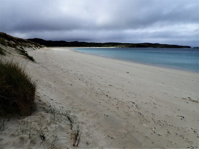
Loch Miabhaig is a picturesque sea loch located in Ross-shire, a county in the Scottish Highlands. Nestled amidst stunning natural surroundings, the loch stretches inland from the coast, forming an estuary that gradually transforms into a narrow creek as it meanders through the landscape.

The loch is characterized by its tranquil waters, which are influenced by tidal movements due to its proximity to the North Atlantic Ocean. At high tide, the sea seamlessly merges with the estuary, creating a seamless transition between the saltwater of the ocean and the freshwater of the loch. This unique blend of habitats supports a diverse range of flora and fauna, making Loch Miabhaig a haven for nature enthusiasts and wildlife photographers.

Surrounded by rolling hills and verdant forests, Loch Miabhaig offers breathtaking views and ample opportunities for outdoor activities. The area is popular with anglers, as the loch is teeming with various fish species, including salmon and trout. It is also a hotspot for birdwatchers, who can observe a plethora of avian species, such as herons, oystercatchers, and terns, among others.

Visitors can explore the loch's shoreline by foot, taking in the picturesque scenery and immersing themselves in the tranquility of the surrounding environment. The nearby village of Ross-shire provides amenities for tourists, including accommodation, dining options, and guided tours of the area.

Overall, Loch Miabhaig, with its stunning natural beauty and diverse ecosystem, offers a delightful experience for anyone seeking to connect with nature and explore the Scottish Highlands.

If you have any feedback on the listing, please let us know in the comments section below.

Loch Miabhaig Images

Images are sourced within 2km of 58.201492/-6.9508304 or Grid Reference NB0934. Thanks to Geograph Open Source API. All images are credited.

Lazy Beds at Tràigh na Beirigh Ridges formed by hand digging of fields.  These one are unusual in that some of the ridges are lined with small stones.
Lazy Beds at Tràigh na Beirigh
Ridges formed by hand digging of fields. These one are unusual in that some of the ridges are lined with small stones.
An Sùileachan Monument A monument to the Lewis land clearances <span class="nowrap"><a title="https://bhaltostrust.co.uk/suileachan-project/" rel="nofollow ugc noopener" href="https://bhaltostrust.co.uk/suileachan-project/">Link</a><img style="margin-left:2px;" alt="External link" title="External link - shift click to open in new window" src="https://s1.geograph.org.uk/img/external.png" width="10" height="10"/></span>
An Sùileachan Monument
A monument to the Lewis land clearances LinkExternal link
A slipway in Loch Miabhaig
Berie Sands Caravan Park Busy site at Traigh na Beirigh with many caravans parked on the machair above the extensive sands.
Berie Sands Caravan Park
Busy site at Traigh na Beirigh with many caravans parked on the machair above the extensive sands.
A' Bheirigh from Suaineabhal
Lochan at Cragavig An old boundary wall snakes across the moorland
Lochan at Cragavig
An old boundary wall snakes across the moorland
Cerishader: postbox № HS2 158 A small postbox on the B8011, with its back to Loch Ròg. It is emptied at 9 o'clock each morning, except Sunday.
Cerishader: postbox № HS2 158
A small postbox on the B8011, with its back to Loch Ròg. It is emptied at 9 o'clock each morning, except Sunday.
A' Bheirigh
A' Bheirigh
Carishader postbox The sea inlet is part of Loch Ròg.
Carishader postbox
The sea inlet is part of Loch Ròg.
Old black house walls, Cairisiadar Looking up An Gleann Ruadh.
Old black house walls, Cairisiadar
Looking up An Gleann Ruadh.
Traigh na Beirigh beach Lewis Looking down the length of the beach towards Kneep.
Traigh na Beirigh beach Lewis
Looking down the length of the beach towards Kneep.
Gleann Bhaltois (Glen Valtos) 6 Gleann Bhaltois is a spectacular example of a glacial meltwater channel. At the end of the last Ice Age, about 10,000 years ago, there is thought to have been a lake where Uig Bay now lies, dammed by ice to the west. The outlet from the lake was at the head of what is now Gleann Bhaltois, and carved a deep steep-sided glen, exploiting a fault line in the rocks. At this point, the glen steps down from its winding upper course through a rock fall to the much straighter lower course.
Gleann Bhaltois (Glen Valtos) 6
Gleann Bhaltois is a spectacular example of a glacial meltwater channel. At the end of the last Ice Age, about 10,000 years ago, there is thought to have been a lake where Uig Bay now lies, dammed by ice to the west. The outlet from the lake was at the head of what is now Gleann Bhaltois, and carved a deep steep-sided glen, exploiting a fault line in the rocks. At this point, the glen steps down from its winding upper course through a rock fall to the much straighter lower course.
Gleann Bhaltois (Glen Valtos) 7 Gleann Bhaltois is a spectacular example of a glacial meltwater channel. At the end of the last Ice Age, about 10,000 years ago, there is thought to have been a lake where Uig Bay now lies, dammed by ice to the west. The outlet from the lake was at the head of what is now Gleann Bhaltois, and carved a deep steep-sided glen, exploiting a fault line in the rocks.
Gleann Bhaltois (Glen Valtos) 7
Gleann Bhaltois is a spectacular example of a glacial meltwater channel. At the end of the last Ice Age, about 10,000 years ago, there is thought to have been a lake where Uig Bay now lies, dammed by ice to the west. The outlet from the lake was at the head of what is now Gleann Bhaltois, and carved a deep steep-sided glen, exploiting a fault line in the rocks.
Name That Tune This cheerful accordionist stands just inside a field by the cattle grid on the B8011 north of Cairisiadar. The label at his feet reads 'Name That Tune'.
Name That Tune
This cheerful accordionist stands just inside a field by the cattle grid on the B8011 north of Cairisiadar. The label at his feet reads 'Name That Tune'.
Cairisiadar (Carishader) Though the B8011 has been much improved, there are still some single-track stretches, notably where it crosses narrow bridges which have not been rebuilt, as here at Cairisiadar.
Cairisiadar (Carishader)
Though the B8011 has been much improved, there are still some single-track stretches, notably where it crosses narrow bridges which have not been rebuilt, as here at Cairisiadar.
Miabhaig harbour pontoon View from RIB afloat to pontoon at Miabhaig, Ceann A Tuath Na Hearadh (North Harris).  Compare to <a href="https://www.geograph.org.uk/photo/575251">NB0934 : Miabhaig Jetty</a> taken by Dave Fergusson on 1 Oct 2007.
Miabhaig harbour pontoon
View from RIB afloat to pontoon at Miabhaig, Ceann A Tuath Na Hearadh (North Harris). Compare to NB0934 : Miabhaig Jetty taken by Dave Fergusson on 1 Oct 2007.
Show me another place!

Loch Miabhaig is located at Grid Ref: NB0934 (Lat: 58.201492, Lng: -6.9508304)

Unitary Authority: Na h-Eileanan an Iar

Police Authority: Highlands and Islands

What 3 Words

///rebel.juicy.woven. Near Carloway, Na h-Eileanan Siar

Related Wikis

Loch na Berie

Loch Na Berie is a broch in the Outer Hebrides of Scotland, located approximately 400 yards from the shore, and is thought to have been located on an island...

Flodaigh, Lewis

Flodaigh is a small island in Loch Roag on the west coast of Lewis in the Outer Hebrides of Scotland. It is about 33 hectares (82 acres) in extent and...

Cliff, Lewis

Cliff (Scottish Gaelic: Cliobh) is a small settlement on the Isle of Lewis, in the Outer Hebrides, Scotland. Cliff is within the parish of Uig. The settlement...

Kneep

Kneep (Scottish Gaelic: Cnìp) is a village on the Isle of Lewis, in the Outer Hebrides, Scotland. Kneep is within the parish of Uig.Various archaeological...

Nearby Amenities

Located within 500m of 58.201492,-6.9508304
Passing Place
Lat/Long: 58.1985659/-6.952369
Passing Place
Lat/Long: 58.2036172/-6.9536011
Barrier: cattle_grid
Lat/Long: 58.2013388/-6.9546299
Leisure: slipway
Lat/Long: 58.2020107/-6.953176
Leisure: slipway
Lat/Long: 58.2034502/-6.9543832
Restaurant
Scallop
Lat/Long: 58.2017993/-6.9530219
Ùigean
Name En: Uigen
Name Gd: Ùigean
Place: hamlet
Lat/Long: 58.2026825/-6.9469578
Passing Place
Lat/Long: 58.1996054/-6.9530129
Passing Place
Lat/Long: 58.2013676/-6.9572234
Barrier: cattle_grid
Lat/Long: 58.2017522/-6.9466971
Power: pole
Lat/Long: 58.197517/-6.9509146
Power: pole
Lat/Long: 58.1981776/-6.9514386
Power: pole
Lat/Long: 58.1986777/-6.9518375
Power: pole
Lat/Long: 58.199407/-6.9524133
Power: pole
Lat/Long: 58.2000418/-6.9531922
Power: pole
Lat/Long: 58.2007166/-6.9539865
Power: pole
Lat/Long: 58.2010722/-6.956996
Power: pole
Lat/Long: 58.2017695/-6.9539218
Power: pole
Lat/Long: 58.2011631/-6.9582835
Power: pole
Lat/Long: 58.2012137/-6.9590604
Power: pole
Lat/Long: 58.2050127/-6.9539989
Power: pole
Lat/Long: 58.2046651/-6.9526775
Power: pole
Lat/Long: 58.2042204/-6.9515696
Power: pole
Lat/Long: 58.2037116/-6.950312
Power: pole
Lat/Long: 58.2036499/-6.9492602
Power: pole
Lat/Long: 58.2035615/-6.9479426
Power: pole
Lat/Long: 58.2037623/-6.9471562
Power: pole
Lat/Long: 58.2038992/-6.9465325
Power: pole
Lat/Long: 58.2040116/-6.9460417
Power: pole
Lat/Long: 58.204331/-6.9446626
Power: pole
Lat/Long: 58.2020319/-6.9472198
Power: pole
Lat/Long: 58.2024506/-6.9467594
Power: pole
Lat/Long: 58.2029037/-6.9467706
Power: pole
Lat/Long: 58.2033384/-6.946844
Power: pole
Lat/Long: 58.2036072/-6.9468157
Power: pole
Lat/Long: 58.2035724/-6.9469987
Power: pole
Lat/Long: 58.203111/-6.950273
Power: pole
Lat/Long: 58.2031656/-6.9494458
Power: pole
Lat/Long: 58.2032185/-6.9487095
Power: pole
Lat/Long: 58.2035026/-6.947377
Generator Method: wind_turbine
Generator Source: wind
Generator Type: horizontal_axis
Power: generator
Lat/Long: 58.2039254/-6.9474938
Passing Place
Lat/Long: 58.2041045/-6.9543398
Passing Place
Lat/Long: 58.2045401/-6.9549891
Barrier: cattle_grid
Lat/Long: 58.2014886/-6.9560943
Power: pole
Lat/Long: 58.2013561/-6.954735
Power: pole
Lat/Long: 58.2009226/-6.9556832
Power: pole
Lat/Long: 58.2012302/-6.9555702
Power: pole
Lat/Long: 58.2011515/-6.9561351
Power: pole
Lat/Long: 58.2011093/-6.9569539
Power: pole
Lat/Long: 58.200842/-6.9550196
Power: pole
Lat/Long: 58.2012624/-6.9576926
Power: pole
Lat/Long: 58.2014127/-6.9583933
Power: pole
Lat/Long: 58.2016481/-6.9586921
The data included in this document is from www.openstreetmap.org. The data is made available under ODbL.

Have you been to Loch Miabhaig?

Leave your review of Loch Miabhaig below (or comments, questions and feedback).