Du Porth

Beach in Cornwall

England

Du Porth

Farmland, St Austell Bay Recently cultivated with the tractor at work in one of the farther fields. A footpath follows the field's edge.
Farmland, St Austell Bay Credit: Andrew Smith

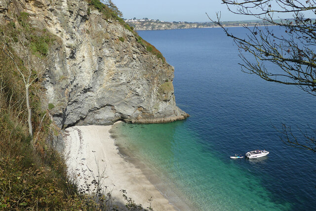
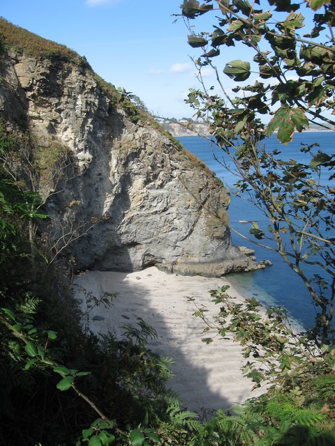
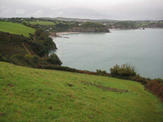
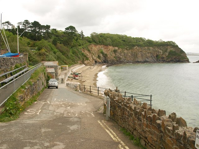
Du Porth is a picturesque beach located on the north coast of Cornwall, England. With its stunning natural beauty, it has become a popular destination for locals and tourists alike. The beach is nestled between towering cliffs, offering breathtaking views of the turquoise waters and golden sands.

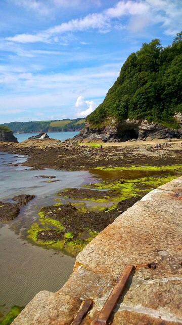
Du Porth beach stretches for approximately half a mile, providing ample space for visitors to relax, sunbathe, and enjoy various beach activities. The sand is soft and fine, making it ideal for building sandcastles or simply strolling along the shoreline. At low tide, a plethora of rock pools are exposed, attracting children and adults alike to explore the fascinating marine life within.

The beach is known for its excellent surfing conditions, attracting surfers of all levels. The waves can vary in size, providing opportunities for beginners to learn and more experienced surfers to challenge themselves. There are several surf schools and rental shops in the area, catering to those looking to ride the waves.

Facilities at Du Porth beach include ample parking, toilets, and a beachside café serving refreshments and snacks. Lifeguards are stationed during peak seasons, ensuring the safety of swimmers and surfers. Dogs are allowed on the beach year-round, making it a popular spot for dog owners to enjoy a walk with their furry companions.

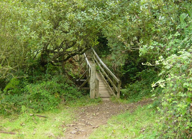
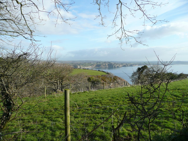
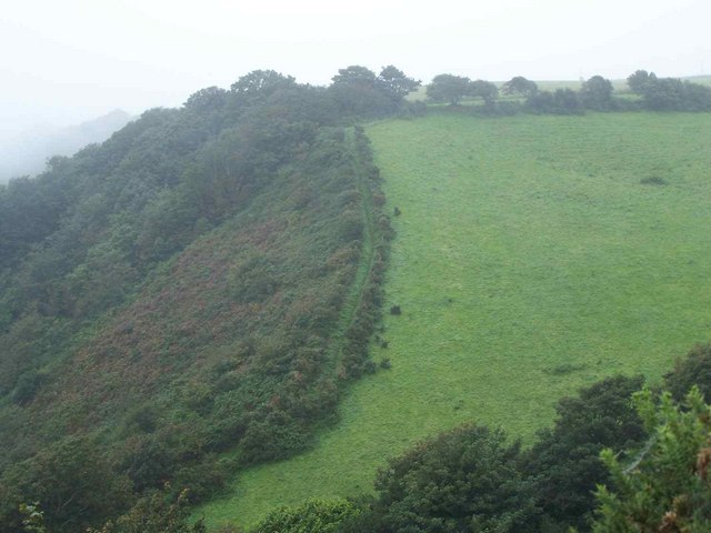
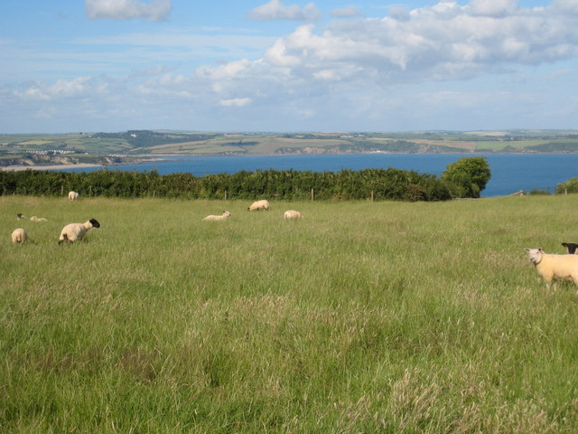
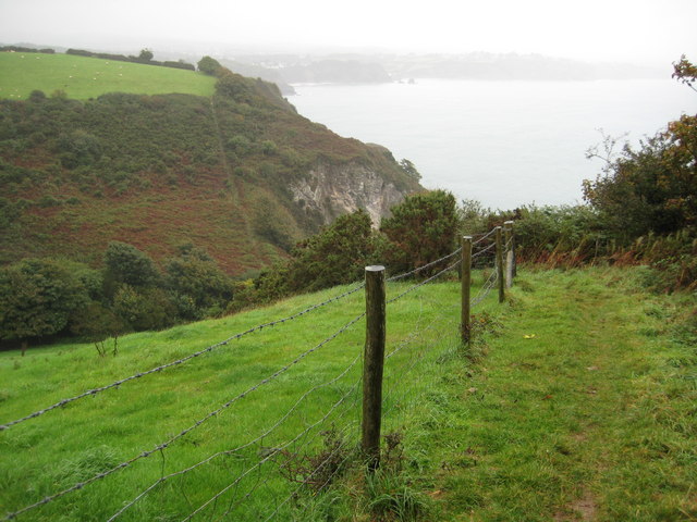
Du Porth beach is surrounded by unspoiled natural beauty, with cliffs providing a habitat for a variety of seabirds, such as gulls and cormorants. The coastal path that runs along the cliffs offers stunning views and is a favorite among hikers and nature enthusiasts.

Overall, Du Porth beach offers a perfect blend of natural beauty, recreational activities, and convenient amenities, making it a must-visit destination for beach lovers visiting Cornwall.

If you have any feedback on the listing, please let us know in the comments section below.

Du Porth Images

Images are sourced within 2km of 50.327465/-4.7613643 or Grid Reference SX0351. Thanks to Geograph Open Source API. All images are credited.

Farmland, St Austell Bay Recently cultivated with the tractor at work in one of the farther fields. A footpath follows the field's edge.
Farmland, St Austell Bay
Recently cultivated with the tractor at work in one of the farther fields. A footpath follows the field's edge.
Coastline, St Austell Bay Silvermine Point viewed from the coast path to its south.
Coastline, St Austell Bay
Silvermine Point viewed from the coast path to its south.
Silvermine Point Silvermine Point (as named on 1:25k map) and small un-named cove, as seen from the South West Coast Path.
Silvermine Point
Silvermine Point (as named on 1:25k map) and small un-named cove, as seen from the South West Coast Path.
Steps on the Coast Path near Silvermine Point The Southwest Coast Path crosses a steep coombe.  You could get this sort of exercise in a gym but it would be much more boring!
Steps on the Coast Path near Silvermine Point
The Southwest Coast Path crosses a steep coombe. You could get this sort of exercise in a gym but it would be much more boring!
Footbridge on the South West Coast Path near Silvermine Point The footbridge crosses a deep but narrow gorge between Phoebe's Point and Gwendra Point. There are 172 steps up both sides of the gorge. Looking south.
Footbridge on the South West Coast Path near Silvermine Point
The footbridge crosses a deep but narrow gorge between Phoebe's Point and Gwendra Point. There are 172 steps up both sides of the gorge. Looking south.
The Ropehaven Cliffsnear to the Blackhead, Cornwall
Lobb's Shop This has been known as Lobb's Shop for at least 70years and is marked on the OS Map, but it has always been housing
Lobb's Shop
This has been known as Lobb's Shop for at least 70years and is marked on the OS Map, but it has always been housing
Footpath and gate The path heads north to Castle Gotha and Higher Porthpean. Lobb's Shop is just beyond the rise of land to the left.
Footpath and gate
The path heads north to Castle Gotha and Higher Porthpean. Lobb's Shop is just beyond the rise of land to the left.
Countryside south of Castle Gotha Looking north with St Austell in the far distance.
Countryside south of Castle Gotha
Looking north with St Austell in the far distance.
A glimpse of the coast Northerly view towards Carrickowel Point and St Austell Bay.
A glimpse of the coast
Northerly view towards Carrickowel Point and St Austell Bay.
Lobb's Shop - from a distance Viewed from the south over pasture land.
Lobb's Shop - from a distance
Viewed from the south over pasture land.
Sheep, Castle Gotha "Maaam, someone's coming". Well, in a minute or two, perhaps. This is where you get to if you follow the footpath described in <a href="https://www.geograph.org.uk/photo/716746">SX0249 : Footpath and gate</a>. On the right is the edge of the bank of the C2 BC settlement described at <span class="nowrap"><a title="http://www.themodernantiquarian.com/site/4911/castle_gotha_settlement.html" rel="nofollow ugc noopener" href="http://www.themodernantiquarian.com/site/4911/castle_gotha_settlement.html">Link</a><img style="margin-left:2px;" alt="External link" title="External link - shift click to open in new window" src="https://s1.geograph.org.uk/img/external.png" width="10" height="10"/></span> , so the encumbrance between me and the lamb is on the line of footpath 413/6/1. A damaged kissing gate, with exposed ends of metal, has been attached to another gate with a chain and twine, and the gate has barbed wire to contend with. This is classified as a "silver" path by Cornwall County Council, which means it calls for "medium term action". Still, it's easier to follow than some of the "bronze" paths in the county.
Sheep, Castle Gotha
"Maaam, someone's coming". Well, in a minute or two, perhaps. This is where you get to if you follow the footpath described in SX0249 : Footpath and gate. On the right is the edge of the bank of the C2 BC settlement described at LinkExternal link , so the encumbrance between me and the lamb is on the line of footpath 413/6/1. A damaged kissing gate, with exposed ends of metal, has been attached to another gate with a chain and twine, and the gate has barbed wire to contend with. This is classified as a "silver" path by Cornwall County Council, which means it calls for "medium term action". Still, it's easier to follow than some of the "bronze" paths in the county.
Cornish Coastal Path, Near Porthpean The path snakes climbs up a steep hill
Cornish Coastal Path, Near Porthpean
The path snakes climbs up a steep hill
Castle Gotha An ancient settlement dating from the C2nd BC. Little evidence remains visible except for the shape of the surrounding hedges, which follow the line of the ramparts <span class="nowrap"><a title="http://www.themodernantiquarian.com/site/4911/castle_gotha_settlement.html" rel="nofollow ugc noopener" href="http://www.themodernantiquarian.com/site/4911/castle_gotha_settlement.html">Link</a><img style="margin-left:2px;" alt="External link" title="External link - shift click to open in new window" src="https://s1.geograph.org.uk/img/external.png" width="10" height="10"/></span>
Castle Gotha
An ancient settlement dating from the C2nd BC. Little evidence remains visible except for the shape of the surrounding hedges, which follow the line of the ramparts LinkExternal link
Field of maize near Castle Gotha Farm Looking across St Austell Bay towards the beach at Carlyon Bay.
Field of maize near Castle Gotha Farm
Looking across St Austell Bay towards the beach at Carlyon Bay.
Coast path near Slivermine Point After a short section of level walking the coast path descends into this valley and climbs steeply out on the north side.
Coast path near Slivermine Point
After a short section of level walking the coast path descends into this valley and climbs steeply out on the north side.
Above Phoebe's Point The coast path above Phoebe's Point with Porth Paen in the background.
Above Phoebe's Point
The coast path above Phoebe's Point with Porth Paen in the background.
Charlestown Beach A view south west along Charlestown beach from the western harbour wall.
Charlestown Beach
A view south west along Charlestown beach from the western harbour wall.
Show me another place!

Du Porth is located at Grid Ref: SX0351 (Lat: 50.327465, Lng: -4.7613643)

Unitary Authority: Cornwall

Police Authority: Devon and Cornwall

What 3 Words

///wimp.status.resold. Near St Austell, Cornwall

Related Wikis

St Austell Bay

St Austell Bay (Cornish: Baya Ti war Dreth) is a bay on Cornwall's south coast which is bounded to the east by Gribbin Head and to the west by Black Head...
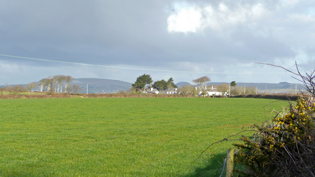
Duporth

Duporth (Cornish: Dewborth; also Duporth Holiday Village) was situated on Porthpean Road, just outside St Austell in south Cornwall, England, UK. For over...

Charlestown, Cornwall

Charlestown (Cornish: Porth Meur, meaning great cove) is a village and port on the south coast of Cornwall, England, in the civil parish of St Austell...

Lower Porthpean

Lower Porthpean is a coastal hamlet in Cornwall, England, UK. It is close to Higher Porthpean and one mile (1.6 km) south of St Austell. == Cornish... ==

Nearby Amenities

Located within 500m of 50.327465,-4.7613643
Source: PGS
Lat/Long: 50.3306429/-4.756774
Source: PGS
Lat/Long: 50.3306122/-4.7565717
WW2 Crinnis Cliff Gun Battery
Alt Name: Charlestown Gun Battery
Building: bunker
Bunker Type: gun_emplacement
Military: bunker
Lat/Long: 50.32944/-4.757552
Old Mine
Historic: ruins
Lat/Long: 50.3302781/-4.7572437
Tourism: viewpoint
Lat/Long: 50.3246961/-4.7627611
Bench
Backrest: yes
Survey Date: 2022-04-09
Lat/Long: 50.3248165/-4.7629832
Tourism: picnic_site
Lat/Long: 50.3247842/-4.7630371
WW2 Quadrant Shelter for Bombing Range
Building: bunker
Bunker Type: personnel_shelter
Military: bunker
Lat/Long: 50.3245204/-4.7649173
Power: substation
Substation: minor_distribution
Lat/Long: 50.3284447/-4.7676925
Bench
Lat/Long: 50.3305073/-4.7572434
Bench
Lat/Long: 50.3295176/-4.7573668
Ele: 63.2m asl
Man Made: flagpole
Lat/Long: 50.3283584/-4.768017
Generator Method: photovoltaic
Generator Output Electricity: yes
Generator Source: solar
Generator Type: solar_photovoltaic_panel
Location: roof
Power: generator
Lat/Long: 50.3280564/-4.7637105
Generator Method: photovoltaic
Generator Output Electricity: yes
Generator Source: solar
Generator Type: solar_photovoltaic_panel
Location: roof
Power: generator
Lat/Long: 50.3283389/-4.7633404
Generator Method: photovoltaic
Generator Output Electricity: yes
Generator Source: solar
Generator Type: solar_photovoltaic_panel
Location: roof
Power: generator
Lat/Long: 50.3281797/-4.7625679
Generator Method: photovoltaic
Generator Output Electricity: yes
Generator Source: solar
Generator Type: solar_photovoltaic_panel
Location: roof
Power: generator
Lat/Long: 50.3288903/-4.7625196
Generator Method: photovoltaic
Generator Output Electricity: yes
Generator Source: solar
Generator Type: solar_photovoltaic_panel
Location: roof
Power: generator
Lat/Long: 50.3289896/-4.7635281
Generator Method: photovoltaic
Generator Output Electricity: yes
Generator Source: solar
Generator Type: solar_photovoltaic_panel
Location: roof
Power: generator
Lat/Long: 50.3286694/-4.7632465
Bench
Lat/Long: 50.3268211/-4.7632955
Generator Method: photovoltaic
Generator Output Electricity: yes
Generator Source: solar
Generator Type: solar_photovoltaic_panel
Location: roof
Power: generator
Lat/Long: 50.3271848/-4.7636649
Generator Method: photovoltaic
Generator Output Electricity: yes
Generator Source: solar
Generator Type: solar_photovoltaic_panel
Location: roof
Power: generator
Lat/Long: 50.3273167/-4.7634637
Generator Method: photovoltaic
Generator Output Electricity: yes
Generator Source: solar
Generator Type: solar_photovoltaic_panel
Location: roof
Power: generator
Lat/Long: 50.3288389/-4.7616506
Generator Method: photovoltaic
Generator Output Electricity: yes
Generator Source: solar
Generator Type: solar_photovoltaic_panel
Location: roof
Power: generator
Lat/Long: 50.3287636/-4.7619858
Generator Method: photovoltaic
Generator Output Electricity: yes
Generator Source: solar
Generator Type: solar_photovoltaic_panel
Location: roof
Power: generator
Lat/Long: 50.3290683/-4.7632492
Generator Method: photovoltaic
Generator Output Electricity: yes
Generator Source: solar
Generator Type: solar_photovoltaic_panel
Location: roof
Power: generator
Lat/Long: 50.3291985/-4.7618195
Generator Method: photovoltaic
Generator Output Electricity: yes
Generator Source: solar
Generator Type: solar_photovoltaic_panel
Location: roof
Power: generator
Lat/Long: 50.329356/-4.7604194
Generator Method: photovoltaic
Generator Output Electricity: yes
Generator Source: solar
Generator Type: solar_photovoltaic_panel
Location: roof
Power: generator
Lat/Long: 50.3298628/-4.7613716
Generator Method: photovoltaic
Generator Output Electricity: yes
Generator Source: solar
Generator Type: solar_photovoltaic_panel
Location: roof
Power: generator
Lat/Long: 50.3298697/-4.7611222
Generator Method: photovoltaic
Generator Output Electricity: yes
Generator Source: solar
Generator Type: solar_photovoltaic_panel
Location: roof
Power: generator
Lat/Long: 50.3293731/-4.7646278
Generator Method: photovoltaic
Generator Output Electricity: yes
Generator Source: solar
Generator Type: solar_photovoltaic_panel
Location: roof
Power: generator
Lat/Long: 50.3295957/-4.7648773
Generator Method: photovoltaic
Generator Output Electricity: yes
Generator Source: solar
Generator Type: solar_photovoltaic_panel
Location: roof
Power: generator
Lat/Long: 50.3264793/-4.7650972
Generator Method: photovoltaic
Generator Output Electricity: yes
Generator Source: solar
Generator Type: solar_photovoltaic_panel
Power: generator
Lat/Long: 50.3263355/-4.7648571
Generator Method: photovoltaic
Generator Output Electricity: yes
Generator Source: solar
Generator Type: solar_photovoltaic_panel
Location: roof
Power: generator
Lat/Long: 50.3268834/-4.767825
Condition: abandoned
Man Made: adit
Lat/Long: 50.3304587/-4.7571372
WW2 Pillbox
Building: bunker
Bunker Type: pillbox
Military: bunker
Lat/Long: 50.329862/-4.7574253
The Wasted Apple Co
Addr City: St Austell
Addr Housename: Southwinds
Addr Postcode: PL26 6AU
Addr Street: Porthpean Beach Road
Craft: brewery
Phone: +447519261717
Product: cider
Website: https://wastedapple.co.uk/
Lat/Long: 50.3264875/-4.7653264
Bench
Backrest: yes
Material: wood
Lat/Long: 50.3308602/-4.7569406
Bench
Backrest: yes
Material: wood
Lat/Long: 50.3308876/-4.7569413
Bench
Backrest: yes
Material: wood
Lat/Long: 50.3309222/-4.7569413
Bus Stop
Manor Farm Road
Bus: yes
Long Name: Duporth Manor Farm Road (S-bound)
Naptan AdministrativeAreaCode: 73
Naptan AtcoCode: 0800COA16232
Naptan Bearing: S
Naptan BusStopType: MKD
Naptan CommonName: Manor Farm Road
Naptan Indicator: S-bound
Naptan LocalityName: Duporth
Naptan ModificationDate: 2023-05-03 14:20
Naptan NptgLocalityCode: N0081085
Naptan RegionCode: corgpawt
Public Transport: platform
Survey Date: 2022-04-09
Lat/Long: 50.330166/-4.766019
Life Ring
Emergency: life_ring
Survey Date: 2022-04-09
Lat/Long: 50.3307778/-4.7568681
Fire Hydrant
Emergency: fire_hydrant
Fire Hydrant Type: underground
Survey Date: 2022-04-09
Lat/Long: 50.330966/-4.7642849
Bus Stop
Manor Farm Road
Bus: yes
Long Name: Duporth Manor Farm Road (N-bound)
Naptan AdministrativeAreaCode: 73
Naptan AtcoCode: 0800COA16231
Naptan Bearing: N
Naptan BusStopType: MKD
Naptan CommonName: Manor Farm Road
Naptan Indicator: N-bound
Naptan LocalityName: Duporth
Naptan ModificationDate: 2020-07-03 09:21
Naptan NptgLocalityCode: N0081085
Naptan RegionCode: corgpawp
Public Transport: platform
Survey Date: 2022-04-09
Lat/Long: 50.3301583/-4.7661986
Post Box
Collection Times: Mo-Fr 09:00; Sa 07:00
Ref: PL26 164D
Royal Cypher: GR
Royal Cypher Wikidata: Q33102273
Survey Date: 2022-04-09
Lat/Long: 50.3260761/-4.7672397
Fire Hydrant
Emergency: fire_hydrant
Fire Hydrant Type: underground
Survey Date: 2022-04-09
Lat/Long: 50.3260229/-4.7670403
Grit Bin
Survey Date: 2022-04-09
Lat/Long: 50.3254522/-4.7649295
Bench
Backrest: yes
Survey Date: 2022-04-09
Lat/Long: 50.325783/-4.7658905
Bench
Backrest: yes
Survey Date: 2022-04-09
Lat/Long: 50.3256265/-4.7653953
Fire Hydrant
Emergency: fire_hydrant
Survey Date: 2022-04-09
Lat/Long: 50.3254844/-4.7649714
Bench
Backrest: yes
Survey Date: 2022-04-09
Lat/Long: 50.3246942/-4.7637178
Bench
Survey Date: 2022-04-09
Lat/Long: 50.32478/-4.7642153
Duporth Beach
Tourism: attraction
Lat/Long: 50.3274954/-4.7614401
Bus Stop
Duporth Pavilion Rise (SE-bound)
Bus: yes
Long Name: Duporth Pavilion Rise (SE-bound)
Naptan AdministrativeAreaCode: 73
Naptan AtcoCode: 0800COA15791
Naptan Bearing: SE
Naptan BusStopType: MKD
Naptan CommonName: Pavilion Rise
Naptan Indicator: SE-bound
Naptan LocalityName: Duporth
Naptan ModificationDate: 2023-05-03 14:36
Naptan NptgLocalityCode: N0081085
Naptan RegionCode: corgjtwp
Public Transport: platform
Lat/Long: 50.32861/-4.7665
Bus Stop
Duporth Rashleigh Road (SW-bound)
Bus: yes
Long Name: Duporth Rashleigh Road (SW-bound)
Naptan AdministrativeAreaCode: 73
Naptan AtcoCode: 0800COA15792
Naptan Bearing: SW
Naptan BusStopType: MKD
Naptan CommonName: Rashleigh Road
Naptan Indicator: SW-bound
Naptan LocalityName: Duporth
Naptan ModificationDate: 2023-05-03 14:38
Naptan NptgLocalityCode: N0081085
Naptan RegionCode: corgjtwt
Public Transport: platform
Lat/Long: 50.32866/-4.76623
Bus Stop
Orchard Way
Bus: yes
Long Name: Duporth, adj Orchard Way
Naptan AdministrativeAreaCode: 73
Naptan AtcoCode: 0800COA16526
Naptan Bearing: S
Naptan BusStopType: CUS
Naptan CommonName: Orchard Way
Naptan Indicator: adj
Naptan LocalityName: Duporth
Naptan ModificationDate: 2023-05-03 15:28
Naptan NptgLocalityCode: N0081085
Naptan RegionCode: corgtadj
Naptan Verified: no
Public Transport: platform
Lat/Long: 50.3285/-4.76792
Bus Stop
Orchard Way
Bus: yes
Long Name: Duporth, opp Orchard Way
Naptan AdministrativeAreaCode: 73
Naptan AtcoCode: 0800COA16527
Naptan Bearing: N
Naptan BusStopType: CUS
Naptan CommonName: Orchard Way
Naptan Indicator: opp
Naptan LocalityName: Duporth
Naptan ModificationDate: 2023-05-03 15:29
Naptan NptgLocalityCode: N0081085
Naptan RegionCode: corgtadm
Naptan Verified: no
Public Transport: platform
Lat/Long: 50.32848/-4.76801
The data included in this document is from www.openstreetmap.org. The data is made available under ODbL.

Have you been to Du Porth?

Leave your review of Du Porth below (or comments, questions and feedback).