Brown's Bay

Bay in Northumberland

England

Brown's Bay

Long Sands, Tynemouth
Long Sands, Tynemouth Credit: habiloid

Brown's Bay is a picturesque coastal area located in Northumberland, England. Situated on the northeastern coast, it is part of the larger Northumberland Coast Area of Outstanding Natural Beauty. The bay stretches approximately 1.5 kilometers and is known for its stunning sandy beach and striking rock formations.

The beach at Brown's Bay offers visitors a tranquil and unspoiled environment. With its golden sand and clear blue waters, it provides the perfect setting for a relaxing day by the sea. The beach is backed by dunes and grassy areas, which provide ample space for picnics and sunbathing.

The bay is also renowned for its remarkable rock formations, which are a result of millions of years of erosion. These unique geological features attract geologists and nature enthusiasts from around the world. The rocks provide a fascinating glimpse into the region's ancient history and are a haven for various marine and bird species.

At low tide, the bay reveals an extensive rock platform, providing an opportunity for exploring rock pools teeming with marine life. It is not uncommon to spot various species of crabs, starfish, and small fish in these pools. The area is also home to a diverse array of birdlife, including oystercatchers, cormorants, and terns, making it a popular spot for birdwatching.

Visitors to Brown's Bay can enjoy a range of activities, including swimming, sunbathing, beachcombing, and wildlife spotting. The bay is easily accessible, with a car park located nearby, and there are facilities such as toilets and a café available for visitors' convenience.

Overall, Brown's Bay offers a beautiful and tranquil coastal experience, making it a must-visit destination for nature lovers and beach enthusiasts alike.

If you have any feedback on the listing, please let us know in the comments section below.

Brown's Bay Images

Images are sourced within 2km of 55.039506/-1.4304097 or Grid Reference NZ3671. Thanks to Geograph Open Source API. All images are credited.

Long Sands, Tynemouth
Grand Parade, Tynemouth St. Georges Church, Cullercoats is in the background.
Grand Parade, Tynemouth
St. Georges Church, Cullercoats is in the background.
Long Sands, Tynemouth
Beverley Terrace, Cullercotes
Northern end of Long Sands
Long Sands, Tynemouth
St. George's Church and The View cafe seen from Long Sands, Tynemouth
Long Sands, Tynemouth
Shelter on the cliffs overlooking Long Sands
Garden between Beverley Terrace and the sea, Cullercoats
Cullercoats Harbour
Cullercoats Harbour
Cullercoats Harbour
Cullercoats Harbour
Cullercoats Harbour
Cullercoats Harbour
Cullercoats Harbour
Cullercoats Harbour
A terrace overlooking Cullercoats Harbour
Steps, Cullercoats Harbour
Cullercoats Harbour
Cullercoats Harbour
Cullercoats Harbour
Cullercoats Harbour
Show me another place!

Brown's Bay is located at Grid Ref: NZ3671 (Lat: 55.039506, Lng: -1.4304097)

Unitary Authority: North Tyneside

Police Authority: Northumbria

What 3 Words

///parts.burst.pocket. Near Whitley Bay, Tyne & Wear

Related Wikis

Dove Marine Laboratory

The Dove Marine Laboratory is a research and teaching laboratory which forms part of the School of Marine Science and Technology within Newcastle University...

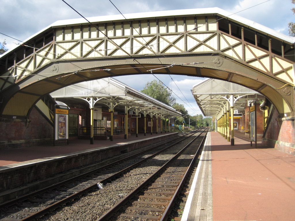
Cullercoats Metro station

Cullercoats is a Tyne and Wear Metro station, serving the suburbs of Cullercoats and Marden, North Tyneside in Tyne and Wear, England. It joined the network...

Cullercoats

Cullercoats is a coastal settlement in the metropolitan borough of North Tyneside, Tyne and Wear, North East England. Historically in Northumberland, it...

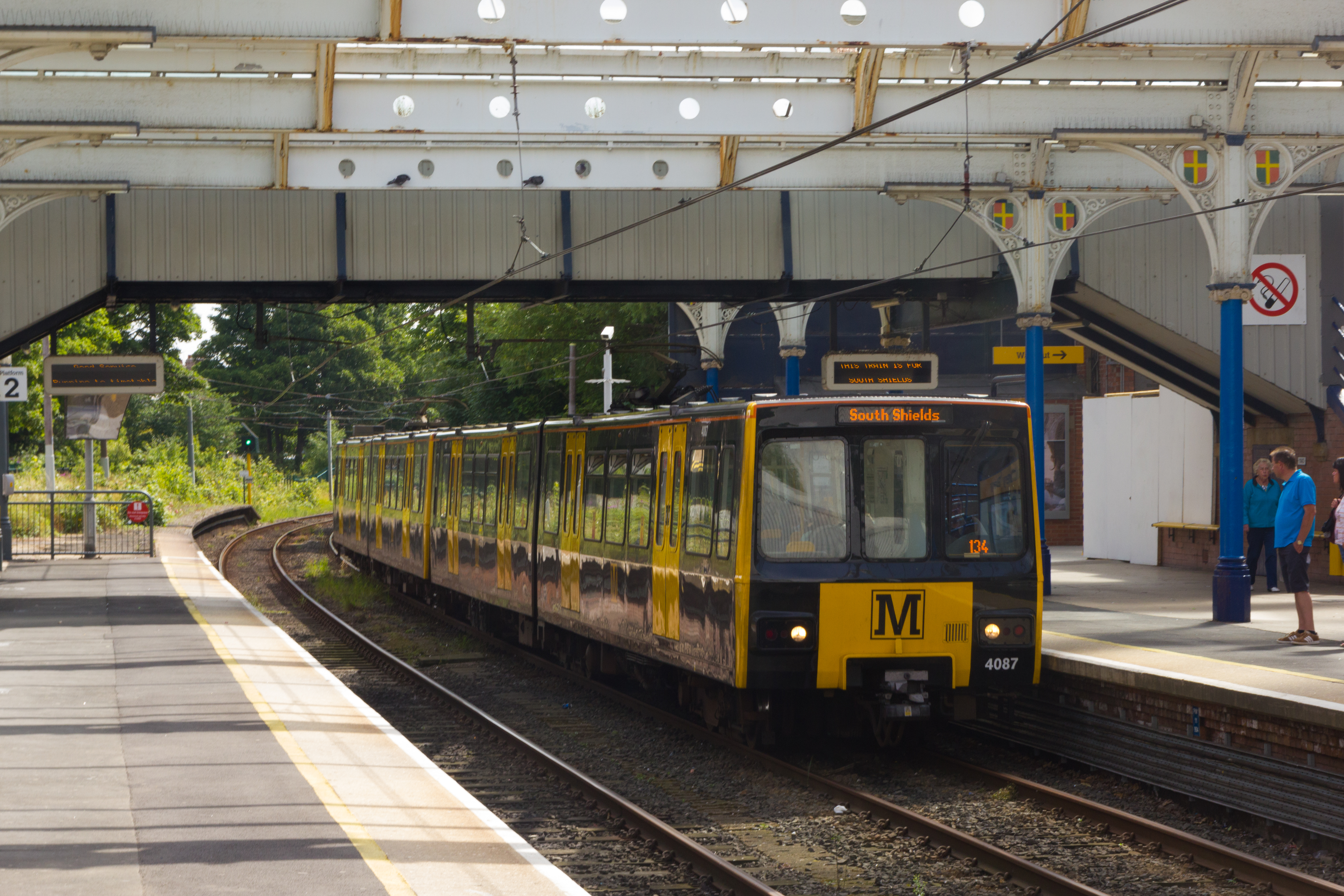
Whitley Bay Metro station

Whitley Bay is a Tyne and Wear Metro station, serving the coastal town of Whitley Bay, North Tyneside in Tyne and Wear, England. It joined the network...

St George's, Cullercoats

St George's Church in Cullercoats, Tyne and Wear, England, is a church built in the 19th-century French Gothic style. It is an active place of worship...

Tynemouth (UK Parliament constituency)

Tynemouth is a constituency in Tyne and Wear represented in the House of Commons of the UK Parliament since 1997 by Sir Alan Campbell, a member of the...
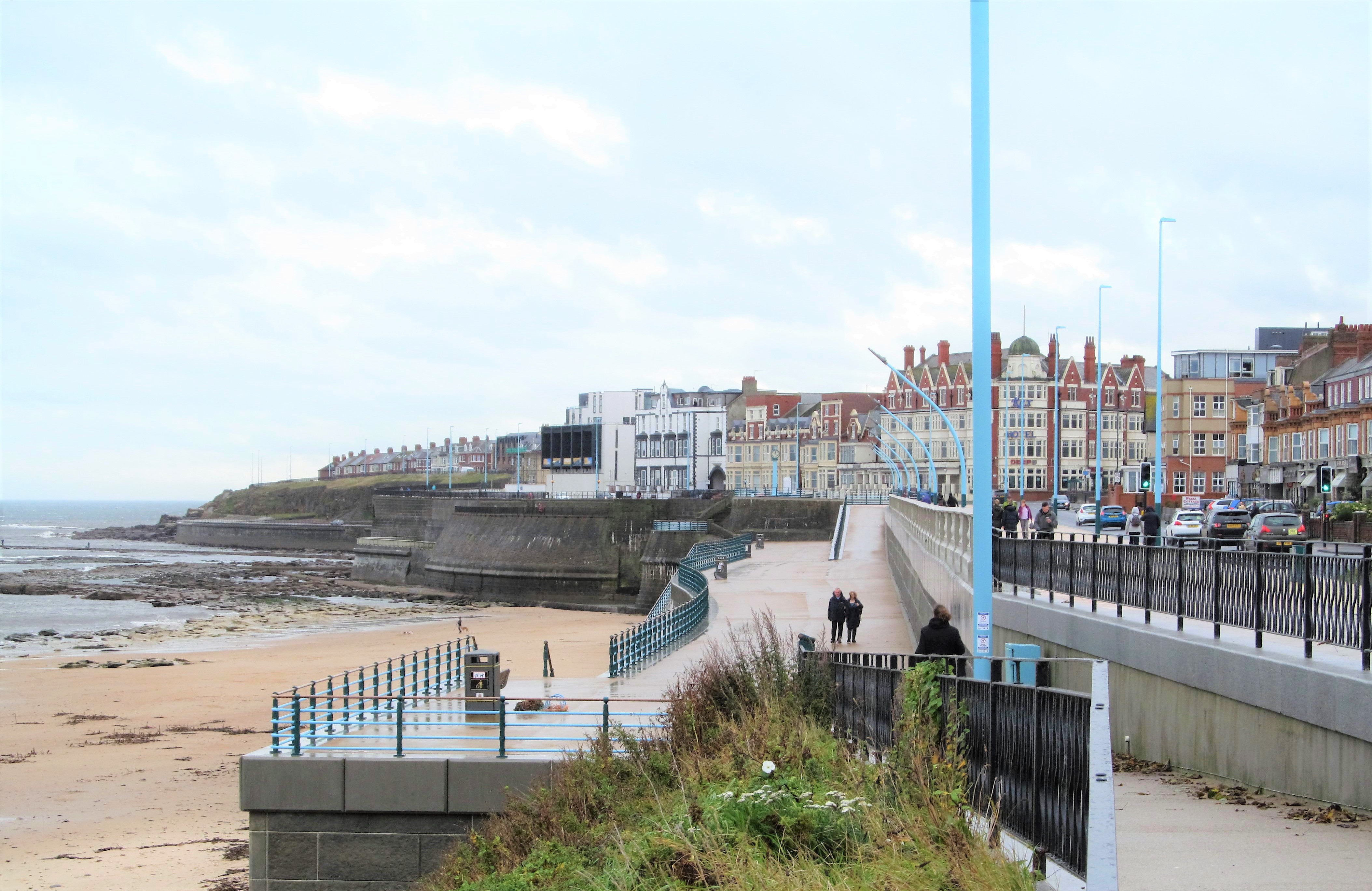
Whitley Bay

Whitley Bay is a seaside town in the North Tyneside borough in Tyne and Wear, England. It formerly governed as part of Northumberland and has been part...

St Paul's Church, Whitley Bay

St Paul's Church is the parish church of Whitley Bay, North Tyneside, United Kingdom.The church was founded in 1864. The church's official title is St...

Nearby Amenities

Located within 500m of 55.039506,-1.4304097
Source: PGS
Lat/Long: 55.0357495/-1.4317791
Crossing
Crossing: uncontrolled
Crossing Island: no
Crossing Ref: zebra
Tactile Paving: yes
Lat/Long: 55.036323/-1.435066
Noexit: yes
Lat/Long: 55.0362411/-1.434017
Crossing
Crossing: unmarked
Crossing Island: yes
Crossing Markings: no
Tactile Paving: no
Lat/Long: 55.0373166/-1.4330425
Bus Stop
CULLERCOATS (M)
Bench: yes
Bus: yes
Departures Board: timetable
Local Ref: N
Naptan AtcoCode: 410000005026
Naptan Bearing: N
Naptan CommonName: CULLERCOATS (M)
Naptan Indicator: N
Naptan Landmark: 37MSOUTH OF NORTH VIEW
Naptan NaptanCode: twragdjm
Naptan Street: JOHN STREET
Naptan Verified: no
Public Transport: platform
Ref: B
Shelter: yes
Source: naptan_import
Lat/Long: 55.0364963/-1.4353244
Bus Stop
WHITLEY ROAD-GRAFTON ROAD-N/B
Bus: yes
Local Ref: NW
Naptan AtcoCode: 410000005027
Naptan Bearing: NW
Naptan CommonName: WHITLEY ROAD-GRAFTON ROAD-N/B
Naptan Indicator: NW
Naptan Landmark: NORTH OF CO-OP
Naptan NaptanCode: twragdjp
Naptan Street: WHITLEY ROAD
Naptan Verified: no
Public Transport: platform
Source: naptan_import
Lat/Long: 55.0384315/-1.4360536
Bus Stop
WHITLEY ROAD-GRAFTON ROAD-S/B
Bench: no
Bus: yes
Departures Board: timetable
Local Ref: SE
Naptan AtcoCode: 410000005038
Naptan Bearing: SE
Naptan CommonName: WHITLEY ROAD-GRAFTON ROAD-S/B
Naptan Indicator: SE
Naptan Landmark: OUTSIDE JUNCTION WITH GRAFTON ROAD/NUMBER 23
Naptan NaptanCode: twragdmj
Naptan Street: WHITLEY ROAD
Naptan Verified: no
Passenger Information Display: no
Public Transport: platform
Shelter: yes
Source: naptan_import
Lat/Long: 55.0390498/-1.436392
Bus Stop
Cullercoats
Bench: yes
Bin: no
Bus: yes
Departures Board: timetable
Local Ref: A
Naptan AtcoCode: 410000005039
Naptan Bearing: S
Naptan CommonName: CULLERCOATS (M)
Naptan Indicator: S
Naptan Landmark: 25M SOUTH OF POST OFFICE
Naptan NaptanCode: twragdmp
Naptan Street: JOHN STREET
Naptan Verified: no
Passenger Information Display: no
Public Transport: platform
Ref: A
Shelter: yes
Source: naptan_import
Lat/Long: 55.0360109/-1.4347319
Bus Stop
FRONT STREET-CLIFF HOUSE-S/B
Bench: no
Bus: yes
Departures Board: timetable
Local Ref: S
Naptan AtcoCode: 410000005950
Naptan Bearing: S
Naptan CommonName: FRONT STREET-CLIFF HOUSE-S/B
Naptan Indicator: S
Naptan Landmark: OUTSIDE CLIFF HOUSE
Naptan NaptanCode: twragjdj
Naptan Street: FRONT STREET
Naptan Verified: no
Public Transport: platform
Shelter: no
Source: naptan_import
Lat/Long: 55.0360179/-1.4320264
Bus Stop
Front Street - Bay Hotel (N/B)
Local Ref: NE
Naptan AtcoCode: 410000005951
Naptan Bearing: NE
Naptan CommonName: FRONT STREET-BAY HOTEL-N/B
Naptan Indicator: NE
Naptan Landmark: OUTSIDE BAY HOTEL
Naptan NaptanCode: twragjdm
Naptan Street: FRONT STREET
Naptan Verified: no
Source: naptan_import
Lat/Long: 55.0357157/-1.4324958
GM Hair And Beauty
Addr Housenumber: 15
Shop: hairdresser
Source: OS OpenData StreetView
Lat/Long: 55.0364049/-1.434864
Brown's Bay
Natural: bay
Source: OS OpenData StreetView
Lat/Long: 55.0393006/-1.4300951
Toilets
Fee: no
Female: yes
Image: https://www.geograph.org.uk/photo/6699388
Level: -1
Male: yes
Source: OS_OpenData_StreetView
Wheelchair: no
Lat/Long: 55.0353609/-1.4327051
Noexit: yes
Lat/Long: 55.0374505/-1.4349237
Barrier: entrance
Lat/Long: 55.0355756/-1.4324489
Cullercoates Boat Yard
Board Type: history
Check Date: 2024-03-31
Information: board
Tourism: information
Lat/Long: 55.0371534/-1.4327958
Board Type: history
Information: board
Tourism: information
Lat/Long: 55.0360395/-1.4321189
Board Type: history
Check Date: 2024-03-31
Information: board
Tourism: information
Lat/Long: 55.036182/-1.4319426
Board Type: history
Information: board
Tourism: information
Lat/Long: 55.0372917/-1.432873
A dip and a dive
Board Type: history
Information: board
Tourism: information
Lat/Long: 55.0404413/-1.4316532
Bench
Backrest: yes
Material: metal
Lat/Long: 55.039537/-1.4321349
Bench
Backrest: yes
Material: metal
Lat/Long: 55.0396118/-1.4321828
Bench
Backrest: yes
Material: metal
Lat/Long: 55.0396914/-1.4321409
Bench
Backrest: yes
Material: metal
Lat/Long: 55.0397676/-1.4320834
Bench
Backrest: yes
Material: metal
Lat/Long: 55.0398088/-1.4319492
Waste Basket
Lat/Long: 55.0352893/-1.4330489
Bench
Backrest: yes
Lat/Long: 55.0360562/-1.4319934
Bench
Backrest: yes
Lat/Long: 55.0360642/-1.4319257
Bench
Backrest: yes
Lat/Long: 55.0361144/-1.4318627
Bench
Backrest: yes
Lat/Long: 55.0361605/-1.4318031
Bench
Backrest: yes
Check Date: 2024-03-31
Lat/Long: 55.0362415/-1.4319712
Elite Barbers
Shop: hairdresser
Lat/Long: 55.0379309/-1.4350647
Fast Food
China Coast Takeaway
Addr City: Whitley Bay
Addr Housenumber: 1
Addr Postcode: NE26 2PJ
Addr Street: Eskdale Terrace
Cuisine: chinese
Delivery: yes
Drive Through: no
Fhrs Id: 72593
Opening Hours: Mo 18:00-23:30; We-Th 18:00-23:30; Fr-Sa 18:00-24:00; Su 18:00-23:00
Outdoor Seating: no
Phone: +44 191 253 1198
Takeaway: only
Lat/Long: 55.0378615/-1.4351055
Clinic
Jennifer Brown Chiropodist
Addr Housenumber: 2A
Healthcare: clinic
Opening Hours: Mo 09:00-17:00; Tu 09:00-13:00; We-Th 09:00-17:00; Fr 14:00-17:00; Sa 09:00-13:00
Phone: +44 191 297 1877
Lat/Long: 55.0375863/-1.4349756
Post Box
Brand: Royal Mail
Brand Wikidata: Q638098
Collection Times: Mo-Fr 17:00; Sa 11:45
Drive Through: no
Operator: Royal Mail
Operator Wikidata: Q638098
Post Box Type: pillar
Ref: NE30 58
Royal Cypher: GR
Royal Cypher Wikidata: Q33102273
Lat/Long: 55.0363426/-1.4350064
Post Box
Brand: Royal Mail
Brand Wikidata: Q638098
Collection Times: Mo-Fr 09:00; Sa 07:00
Drive Through: no
Operator: Royal Mail
Operator Wikidata: Q638098
Post Box Type: pillar
Ref: NE26 119
Royal Cypher: VR
Royal Cypher Wikidata: Q33102356
Lat/Long: 55.0380676/-1.4353033
Olivers Book Shop
Addr City: Whitley Bay
Addr Housenumber: 48A
Addr Street: Whitley Road
Opening Hours: Mo 11:00-16:00; Th-Sa 11:00-16:00
Shop: books
Lat/Long: 55.0394379/-1.4369143
Post Box
Brand: Royal Mail
Brand Wikidata: Q638098
Collection Times: Mo-Fr 09:00; Sa 07:00
Drive Through: no
Operator: Royal Mail
Operator Wikidata: Q638098
Post Box Type: pillar
Ref: NE26 292
Royal Cypher: EVIIR
Royal Cypher Wikidata: Q33102324
Lat/Long: 55.0393844/-1.436996
Clinic
Whitley Bay Osteopathic Centre
Addr City: Whitley Bay
Addr Housenumber: 65
Addr Street: Whitley Road
Lat/Long: 55.0393616/-1.4374444
Splinters
Addr City: Whitley Bay
Addr Housenumber: 62
Addr Street: Whitley Road
Phone: +44 191 251 2882
Shop: hairdresser
Lat/Long: 55.0397322/-1.4374374
WASH-A-RAMA
Addr City: Whitley Bay
Addr Street: Whitley Road
Shop: dry_cleaning
Lat/Long: 55.0397671/-1.4375177
Bayside Stitchers
Addr City: Whitley Bay
Addr Street: Whitley Road
Phone: +44 191 252 0333
Shop: tailor
Lat/Long: 55.0398097/-1.437592
Bluebells
Addr Housenumber: 70
Shop: florist
Lat/Long: 55.039854/-1.4376776
Kork Wine And Deli
Addr City: Whitley Bay
Addr County: Tyne And Wear
Addr Housenumber: 74
Addr Postcode: NE26 2NE
Addr Street: Whitley Road
Fhrs Id: 1367755
Shop: deli
Lat/Long: 55.039886/-1.4377381
Coccolare
Addr City: Whitley Bay
Addr Housenumber: 76
Addr Street: Whitley Road
Phone: +44 191 252 7778
Shop: hairdresser
Lat/Long: 55.0399233/-1.4378119
Sammy Anne's
Addr Housenumber: 80
Addr Street: Whitley Road
Shop: beauty
Lat/Long: 55.0399694/-1.437887
Brooks Hair Design
Addr City: Whitley Bay
Addr Street: Whitley Road
Fixme: resurvey, believed shut
Phone: +44 191 2902002
Shop: hairdresser
Lat/Long: 55.0401108/-1.4381371
Southcliff Holiday Apartments
Addr City: Whitley Bay
Addr Housenumber: 4
Addr Postcode: NE26 2PB
Addr Street: Southcliff
Check Date: 2024-03-31
Phone: +44 191 2513121
Tourism: guest_house
Website: http://www.southcliffapartments.co.uk
Lat/Long: 55.0380721/-1.4322503
Post Box
Brand: Royal Mail
Brand Wikidata: Q638098
Collection Times: Mo-Fr 09:00, Sa 07:00
Operator: Royal Mail
Operator Wikidata: Q638098
Post Box Type: pillar
Ref: NE26 203
Royal Cypher: GR
Royal Cypher Wikidata: Q33102273
Lat/Long: 55.0395399/-1.4329542
Crossing
Crossing Island: yes
Tactile Paving: no
Lat/Long: 55.0377089/-1.4351046
Bus Stop
Bench: no
Bin: no
Bus: yes
Check Date Shelter: 2024-03-31
Public Transport: platform
Shelter: no
Tactile Paving: no
Lat/Long: 55.0367915/-1.4327018
Barrier: bollard
Bollard: fixed
Foot: yes
Lat/Long: 55.0415945/-1.4353325
Barrier: bollard
Bollard: fixed
Foot: yes
Lat/Long: 55.0408331/-1.4327377
The Birdlife of Cullercoats Bay
Board Type: nature
Information: board
Tourism: information
Lat/Long: 55.0365191/-1.4313005
Life Ring
Emergency: life_ring
Lat/Long: 55.0402818/-1.4314158
Crossing
Crossing: zebra;marked
Crossing Ref: zebra
Tactile Paving: yes
Lat/Long: 55.0378948/-1.4355831
Bus Stop
Bench: no
Bus: yes
Naptan AtcoCode: 410000005075
Naptan NaptanCode: twrjdgpm
Public Transport: platform
Shelter: no
Lat/Long: 55.0413207/-1.43408
Azendo Beauty Lounge
Shop: beauty
Lat/Long: 55.036817/-1.4352992
Life Ring
Emergency: life_ring
Lat/Long: 55.0390796/-1.4322379
Bench
Backrest: yes
Lat/Long: 55.0358246/-1.4321675
Bench
Backrest: yes
Lat/Long: 55.0358482/-1.4321183
Barrier: bollard
Bicycle: yes
Foot: yes
Motor Vehicle: no
Lat/Long: 55.0415517/-1.4365629
Social Facility
Falmouth House
Addr City: Whitley Bay
Addr Country: GB
Addr Housenumber: 24
Addr Postcode: NE26 2BJ
Addr Street: Edwards Road
Fhrs Id: 449833
Lat/Long: 55.0409984/-1.4370428
Childcare
Rainbow Childcare
Addr City: Whitley Bay
Addr Country: GB
Addr Housename: Rockcliffe Hall
Addr Postcode: NE26 2NW
Addr Street: Rockcliffe Street
Email: rainbowchildcarewhitleybay@hotmail.com
Fhrs Id: 17958
Max Age: 5
Min Age: 0
Website: http://www.goodtimechildcare.co.uk/index.php/5/
Lat/Long: 55.0407606/-1.4351577
Addr Housenumber: 11
Lat/Long: 55.0405526/-1.4349718
Addr Housenumber: 61
Lat/Long: 55.0394112/-1.4345943
Addr Housenumber: 18
Addr Street: Margaret Road
Lat/Long: 55.0384831/-1.4347301
Addr Housenumber: 57
Lat/Long: 55.0374345/-1.4339801
Addr Housenumber: 74
Lat/Long: 55.037454/-1.4336922
Addr Housenumber: 28
Lat/Long: 55.0364989/-1.4332302
Bus: yes
Public Transport: stop_position
Lat/Long: 55.0384834/-1.4360105
Bus: yes
Public Transport: stop_position
Lat/Long: 55.038989/-1.4364772
Bus: yes
Public Transport: stop_position
Lat/Long: 55.0400011/-1.4382005
Leisure: slipway
Seamark Small Craft Facility Category: slipway
Seamark Type: small_craft_facility
Lat/Long: 55.0350627/-1.431562
Barrier: bollard
Lat/Long: 55.0374911/-1.4338205
Bus: yes
Public Transport: stop_position
Lat/Long: 55.0359453/-1.4347583
Cullercoats RNLI Shop
Shop: gift
Website: https://rnli.org/find-my-nearest/shops/cullercoats-rnli-shop
Lat/Long: 55.035523/-1.4319322
Bench
Backrest: yes
Lat/Long: 55.0354347/-1.4326141
Bench
Backrest: yes
Lat/Long: 55.0353102/-1.4327596
Give Way
Direction: forward
Lat/Long: 55.0375527/-1.4326791
Entrance: yes
Lat/Long: 55.0353237/-1.4326755
Crossing
Crossing Island: no
Crossing Markings: no
Crossing Signals: no
Tactile Paving: no
Lat/Long: 55.0377043/-1.4329443
Crossing
Crossing Island: no
Crossing Markings: no
Crossing Signals: no
Tactile Paving: no
Lat/Long: 55.0364897/-1.4321254
Barrier: lift_gate
Lift Gate Type: single
Locked: yes
Lat/Long: 55.0370768/-1.4327207
The data included in this document is from www.openstreetmap.org. The data is made available under ODbL.

Have you been to Brown's Bay?

Leave your review of Brown's Bay below (or comments, questions and feedback).