Aberdeen Bay

Bay in Aberdeenshire

Scotland

Aberdeen Bay

First Aberdeen bus depot and offices, King Street The building is a nicely restored militia barracks from ca. 1861: <span class="nowrap"><a title="http://data.historic-scotland.gov.uk/pls/htmldb/f?p=2200:15:0::::BUILDING:19998" rel="nofollow ugc noopener" href="http://data.historic-scotland.gov.uk/pls/htmldb/f?p=2200:15:0::::BUILDING:19998">Link</a><img style="margin-left:2px;" alt="External link" title="External link - shift click to open in new window" src="https://s1.geograph.org.uk/img/external.png" width="10" height="10"/></span> .
First Aberdeen bus depot and offices, King Street Credit: Bill Harrison

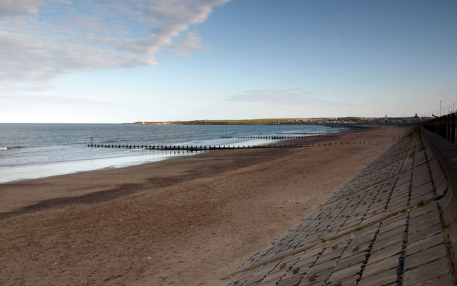
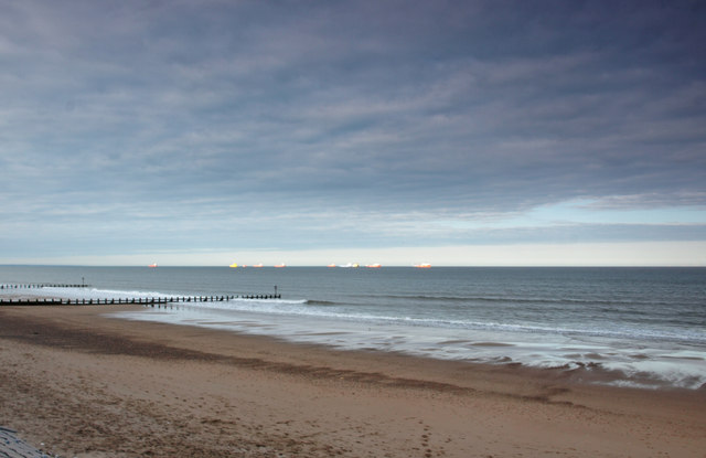
Aberdeen Bay is a picturesque bay located in Aberdeenshire, Scotland. It is situated on the northeastern coast of Scotland, approximately 2 miles north of the city of Aberdeen. The bay is known for its stunning natural beauty, with its sandy beaches, rugged cliffs, and crystal-clear waters.

The bay stretches about 1.5 miles in length and is surrounded by rolling hills and picturesque countryside. It is a popular destination for outdoor enthusiasts and nature lovers, offering a wide range of activities such as swimming, fishing, sailing, and birdwatching.

One of the main attractions of Aberdeen Bay is the famous Aberdeen Beach, which is located at the southern end of the bay. This sandy beach stretches for approximately 2 miles and offers visitors a chance to relax, sunbathe, and enjoy various water sports. The beach is also home to a lively promenade, lined with shops, restaurants, and amusement arcades.

The bay is also known for its rich wildlife, with a variety of bird species, including gulls and terns, making it their home. Additionally, seals can often be spotted lounging on the rocks or swimming in the bay's waters.

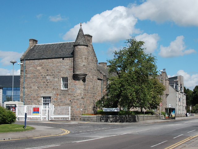
Aberdeen Bay is easily accessible, with a well-connected road network and public transportation options. It is a popular destination for both locals and tourists, providing a perfect blend of natural beauty, recreational activities, and stunning coastal scenery. Whether one seeks a peaceful coastal getaway or an active beach holiday, Aberdeen Bay offers something for everyone.

If you have any feedback on the listing, please let us know in the comments section below.

Aberdeen Bay Images

Images are sourced within 2km of 57.157824/-2.0721244 or Grid Reference NJ9507. Thanks to Geograph Open Source API. All images are credited.

First Aberdeen bus depot and offices, King Street The building is a nicely restored militia barracks from ca. 1861: <span class="nowrap"><a title="http://data.historic-scotland.gov.uk/pls/htmldb/f?p=2200:15:0::::BUILDING:19998" rel="nofollow ugc noopener" href="http://data.historic-scotland.gov.uk/pls/htmldb/f?p=2200:15:0::::BUILDING:19998">Link</a><img style="margin-left:2px;" alt="External link" title="External link - shift click to open in new window" src="https://s1.geograph.org.uk/img/external.png" width="10" height="10"/></span> .
First Aberdeen bus depot and offices, King Street
The building is a nicely restored militia barracks from ca. 1861: LinkExternal link .
War memorial, St Peter's Cemetery, King Street
Cemetery lodges, St Peter's Cemetery, King Street Thought to date from about 1824 and B-listed: <span class="nowrap"><a title="http://data.historic-scotland.gov.uk/pls/htmldb/f?p=2200:15:0::::BUILDING:20060" rel="nofollow ugc noopener" href="http://data.historic-scotland.gov.uk/pls/htmldb/f?p=2200:15:0::::BUILDING:20060">Link</a><img style="margin-left:2px;" alt="External link" title="External link - shift click to open in new window" src="https://s1.geograph.org.uk/img/external.png" width="10" height="10"/></span> , when the commercial cemetery was set up by the Moir of Scotstoun family: their rather ominous skull and cross bones crest still adorns the iron gates.  The round nodule things on the corners of the roof are called acroters.
Cemetery lodges, St Peter's Cemetery, King Street
Thought to date from about 1824 and B-listed: LinkExternal link , when the commercial cemetery was set up by the Moir of Scotstoun family: their rather ominous skull and cross bones crest still adorns the iron gates. The round nodule things on the corners of the roof are called acroters.
Moir of Scotstoun crest, St Peter's Cemetery, King Street The ominous crest of Moir of Scotstoun (who once owned the land) on the gates of St Peter's Cemetery on King Street; compare: <a title="https://www.geograph.org.uk/photo/4363024" href="https://www.geograph.org.uk/photo/4363024">Link</a> .  The motto means "not for self but for all".
Moir of Scotstoun crest, St Peter's Cemetery, King Street
The ominous crest of Moir of Scotstoun (who once owned the land) on the gates of St Peter's Cemetery on King Street; compare: Link . The motto means "not for self but for all".
High Street, Old Aberdeen The building in the centre is the "Confucius Institute" set up to facilitate cooperation between the University of Aberdeen and China.  Could the yellow "88" on the left-hand building be a fire insurance mark?
High Street, Old Aberdeen
The building in the centre is the "Confucius Institute" set up to facilitate cooperation between the University of Aberdeen and China. Could the yellow "88" on the left-hand building be a fire insurance mark?
Crown tower, King's College Chapel Dating from around 1500 and A-listed: <span class="nowrap"><a title="http://www.britishlistedbuildings.co.uk/sc-19943-kings-college-chapel-college-bounds-#.Vc5STaSFOmQhttp://www.britishlistedbuildings.co.uk/sc-19943-kings-college-chapel-college-bounds-#.Vc5STaSFOmQ" rel="nofollow ugc noopener" href="http://www.britishlistedbuildings.co.uk/sc-19943-kings-college-chapel-college-bounds-#.Vc5STaSFOmQhttp://www.britishlistedbuildings.co.uk/sc-19943-kings-college-chapel-college-bounds-#.Vc5STaSFOmQ">Link</a><img style="margin-left:2px;" alt="External link" title="External link - shift click to open in new window" src="https://s1.geograph.org.uk/img/external.png" width="10" height="10"/></span> .
Crown tower, King's College Chapel
Dating from around 1500 and A-listed: LinkExternal link .
King's College Chapel, Old Aberdeen
Beach at Aberdeen Viewed from below the Esplanade. There are groynes spread along the beach. View towards the lighthouses at the entrance to the harbour.
Beach at Aberdeen
Viewed from below the Esplanade. There are groynes spread along the beach. View towards the lighthouses at the entrance to the harbour.
Beach at Aberdeen Looking northwards.
Beach at Aberdeen
Looking northwards.
Provost Skene's House Aberdeen's second oldest house, dating from 1545.
Provost Skene's House
Aberdeen's second oldest house, dating from 1545.
Marischal College, Aberdeen This fine granite building was appropriately still home to Aberdeen University's Geology Department when this photograph was taken in 1979.
Marischal College, Aberdeen
This fine granite building was appropriately still home to Aberdeen University's Geology Department when this photograph was taken in 1979.
Dining Room, Provost Skene's House The dining room as arranged in 1979.
Dining Room, Provost Skene's House
The dining room as arranged in 1979.
Bedroom, Provost Skene's House One of the period bedrooms, as arranged in 1979.
Bedroom, Provost Skene's House
One of the period bedrooms, as arranged in 1979.
Victorian parlour, Provost Skene's House Complete with Aspidistra, as seen in 1979.
Victorian parlour, Provost Skene's House
Complete with Aspidistra, as seen in 1979.
Interior, Provost Skene's House Period setting, as seen in 1979.
Interior, Provost Skene's House
Period setting, as seen in 1979.
Rebranding exercise North East Scotland College (see: <span class="nowrap"><a title="https://en.wikipedia.org/wiki/North_East_Scotland_College" rel="nofollow ugc noopener" href="https://en.wikipedia.org/wiki/North_East_Scotland_College">Link</a><img style="margin-left:2px;" alt="External link" title="External link - shift click to open in new window" src="https://s1.geograph.org.uk/img/external.png" width="10" height="10"/></span> ) arose from the shotgun marriage between Aberdeen College and Banff and Buchan College in November 2013.  As well as a new logo, the main building in Aberdeen was re-clad in contemporary greys...  It formerly looked like... <a title="https://www.geograph.org.uk/photo/852689" href="https://www.geograph.org.uk/photo/852689">Link</a> .
Rebranding exercise
North East Scotland College (see: LinkExternal link ) arose from the shotgun marriage between Aberdeen College and Banff and Buchan College in November 2013. As well as a new logo, the main building in Aberdeen was re-clad in contemporary greys... It formerly looked like... Link .
Mortification boards, Town House, Aberdeen There are almost 100 of these intriguing Seventeenth Century mortification boards in the entrance hall of the Town House.  They commemorate bequests made by wealthy and leading citizens.  The nearest one commemorates Katherine Gordon, Lady Rothiemay (née Forbes), who seemed to have a colourful life: <span class="nowrap"><a title="http://womenofscotland.org.uk/women/katherine-forbes-lady-rothiemay" rel="nofollow ugc noopener" href="http://womenofscotland.org.uk/women/katherine-forbes-lady-rothiemay">Link</a><img style="margin-left:2px;" alt="External link" title="External link - shift click to open in new window" src="https://s1.geograph.org.uk/img/external.png" width="10" height="10"/></span> .  The crest shows Azure a saltire argent between three boars' heads couped or (for Gordon) impaling Azure three bears' heads couped argent muzzled gules (for Forbes).
Mortification boards, Town House, Aberdeen
There are almost 100 of these intriguing Seventeenth Century mortification boards in the entrance hall of the Town House. They commemorate bequests made by wealthy and leading citizens. The nearest one commemorates Katherine Gordon, Lady Rothiemay (née Forbes), who seemed to have a colourful life: LinkExternal link . The crest shows Azure a saltire argent between three boars' heads couped or (for Gordon) impaling Azure three bears' heads couped argent muzzled gules (for Forbes).
Shopping centre The upper level of the Bon Accord shopping centre.
Shopping centre
The upper level of the Bon Accord shopping centre.
Show me another place!

Aberdeen Bay is located at Grid Ref: NJ9507 (Lat: 57.157824, Lng: -2.0721244)

Unitary Authority: City of Aberdeen

Police Authority: North East

What 3 Words

///slimy.mild.once. Near Aberdeen

Nearby Locations

Aberdeen Bay Broad Hill

Related Wikis

Nearby Amenities

Located within 500m of 57.157824,-2.0721244
Source: PGS
Lat/Long: 57.1550661/-2.0774603
Source: PGS
Lat/Long: 57.1560194/-2.0777251
Source: PGS
Lat/Long: 57.1569872/-2.0779227
Source: PGS
Lat/Long: 57.1579681/-2.0780456
Source: PGS
Lat/Long: 57.158928/-2.0781366
Source: PGS
Lat/Long: 57.159893/-2.078209
Crossing
Crossing: uncontrolled
Crossing Island: no
Crossing Markings: zebra
Crossing Ref: zebra
Flashing Lights: yes
Tactile Paving: yes
Lat/Long: 57.1558389/-2.0791771
Life Ring
Emergency: life_ring
Lat/Long: 57.1597106/-2.079294
Life Ring
Emergency: life_ring
Lat/Long: 57.1579178/-2.0791666
Life Ring
Emergency: life_ring
Lat/Long: 57.1569061/-2.0789809
Life Ring
Emergency: life_ring
Lat/Long: 57.1559562/-2.0787629
Life Ring
Emergency: life_ring
Lat/Long: 57.1550299/-2.0786034
Life Ring
Emergency: life_ring
Lat/Long: 57.1586913/-2.0791277
Bench
Source: survey
Lat/Long: 57.1567698/-2.0790352
Bench
Source: survey
Lat/Long: 57.1573247/-2.0791599
Bench
Source: survey
Lat/Long: 57.157124/-2.0791183
Bench
Source: survey
Lat/Long: 57.1557867/-2.0788092
Bench
Source: survey
Lat/Long: 57.1556144/-2.078769
Bench
Source: survey
Lat/Long: 57.1559908/-2.0788568
Bench
Source: survey
Lat/Long: 57.1561184/-2.0788907
Bench
Source: survey
Lat/Long: 57.1554005/-2.0787294
Bench
Source: survey
Lat/Long: 57.1552878/-2.0787194
Bench
Source: survey
Lat/Long: 57.1551652/-2.07871
The data included in this document is from www.openstreetmap.org. The data is made available under ODbL.

Have you been to Aberdeen Bay?

Leave your review of Aberdeen Bay below (or comments, questions and feedback).