Boak Port

Bay in Wigtownshire

Scotland

Boak Port

Balscalloch Radio Mast Located on Craignawachel at the northern tip of the North Rhins.
Balscalloch Radio Mast Credit: Jon Alexander

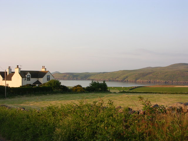
Boak Port is a picturesque bay located in Wigtownshire, which is situated in the southwestern part of Scotland. It is nestled along the scenic coast of the Solway Firth, about 4 miles northwest of the town of Whithorn. This charming coastal area is renowned for its natural beauty, tranquility, and rich maritime history.

Boak Port boasts a stunning sandy beach that stretches for approximately half a mile, providing visitors with an ideal spot for relaxation and leisurely walks. The bay is surrounded by rolling hills and lush greenery, creating a breathtaking backdrop that attracts nature enthusiasts and photographers alike.

The bay is also known for its thriving birdlife, making it a popular destination for birdwatchers. Various species of seabirds, including gannets, cormorants, and oystercatchers, can often be spotted in the area, making it a haven for wildlife enthusiasts.

In addition to its natural charm, Boak Port has a rich history as a former fishing port. It was once a bustling hub for fishing vessels, and remnants of the old port can still be seen today. The bay's maritime heritage is celebrated through local events and festivals, which attract both locals and tourists.

Boak Port is a hidden gem that offers a peaceful retreat for those seeking a break from the hustle and bustle of city life. Its stunning coastline, diverse wildlife, and fascinating history make it a must-visit destination for anyone exploring the beautiful region of Wigtownshire.

If you have any feedback on the listing, please let us know in the comments section below.

Boak Port Images

Images are sourced within 2km of 55.018101/-5.1038199 or Grid Reference NX0173. Thanks to Geograph Open Source API. All images are credited.

Balscalloch Radio Mast Located on Craignawachel at the northern tip of the North Rhins.
Balscalloch Radio Mast
Located on Craignawachel at the northern tip of the North Rhins.
Milleur Point With navigation buoy and Craignawachel communications mast.
Milleur Point
With navigation buoy and Craignawachel communications mast.
 Stena Line Ferry passing Milleur Point Heading into Loch Ryan.
Stena Line Ferry passing Milleur Point
Heading into Loch Ryan.
Dundream View along the north coast of the Rhinns towards the head of Loch Ryan.
Dundream
View along the north coast of the Rhinns towards the head of Loch Ryan.
All Blue at Dundream Calm blue sea and blue sky when I visited this part of the North Rhinns.
All Blue at Dundream
Calm blue sea and blue sky when I visited this part of the North Rhinns.
East Balscalloch Farm This picture looks North East from my office window in East Balscalloch Farm. Across the mouth of Loch Ryan towards Ballantrae.
East Balscalloch Farm
This picture looks North East from my office window in East Balscalloch Farm. Across the mouth of Loch Ryan towards Ballantrae.
Milleur Point This is taken from Milleur Point - the most Northern tip of the Rhins looking North East. A buoy in the foreground directs the ferries around the shallower waters near the shore.
Milleur Point
This is taken from Milleur Point - the most Northern tip of the Rhins looking North East. A buoy in the foreground directs the ferries around the shallower waters near the shore.
North Rhins across the mouth of Loch Ryan Taken from the lane Approaching East Balscalloch Farm
North Rhins across the mouth of Loch Ryan
Taken from the lane Approaching East Balscalloch Farm
Stena Voyager At Milleur Point Viewed as the ferry returned from Belfast, entering Loch Ryan on its way to Stranraer.  The coast of Northern Ireland is just visible through the haze.
Stena Voyager At Milleur Point
Viewed as the ferry returned from Belfast, entering Loch Ryan on its way to Stranraer. The coast of Northern Ireland is just visible through the haze.
Mast, The Rhins Dumfries and Galloway
Mast, The Rhins
Dumfries and Galloway
Ballscalloch Cottage, The Rhins You can just pick out Aisla Craig between two poles near the right of frame.
Ballscalloch Cottage, The Rhins
You can just pick out Aisla Craig between two poles near the right of frame.
West Ballscalloch Farm, The Rhins
Harvested Fields, The Rhins The farm in the distance is Heighton Farm.
Harvested Fields, The Rhins
The farm in the distance is Heighton Farm.
Portencalzie, The Rhins
Coastal Path from Lady Bay The signpost says 'Footpath 1400m' but the other signs say 'Electric Fence' in 7 languages, and 'Bull Keep Out'.  
The path over the walls is obscured by bracken, leads to a steep slope with a very long drop to Loch Ryan.
Coastal Path from Lady Bay
The signpost says 'Footpath 1400m' but the other signs say 'Electric Fence' in 7 languages, and 'Bull Keep Out'. The path over the walls is obscured by bracken, leads to a steep slope with a very long drop to Loch Ryan.
Sea Loch - Loch Ryan This is the sea loch, Loch Ryan.  The entrance to the loch can be seen together with  a high-speed ferry.  The ferry has just rounded Corsewall Point on its way from Northern Ireland.
Sea Loch - Loch Ryan
This is the sea loch, Loch Ryan. The entrance to the loch can be seen together with a high-speed ferry. The ferry has just rounded Corsewall Point on its way from Northern Ireland.
Wave breaking near Marsh Slung The wash from  a ferry, now well out of sight. Small craft are advised to beware of such waves, some casualties have resulted.
Wave breaking near Marsh Slung
The wash from a ferry, now well out of sight. Small craft are advised to beware of such waves, some casualties have resulted.
Wheat field above Loch Ryan The yacht is anchored in Lady Bay.
Wheat field above Loch Ryan
The yacht is anchored in Lady Bay.
Show me another place!

Boak Port is located at Grid Ref: NX0173 (Lat: 55.018101, Lng: -5.1038199)

Unitary Authority: Dumfries and Galloway

Police Authority: Dumfries and Galloway

What 3 Words

///fatherly.preheated.simulator. Near Cairnryan, Dumfries & Galloway

Related Wikis

Corsewall Point

Corsewall Point, or Corsill Point, is a headland at the northern end of the Rhins of Galloway in Scotland. A lighthouse, Corsewall Lighthouse, was placed...

Kirkcolm

Kirkcolm (Scots: Kirkcoam) is a village and civil parish on the northern tip of the Rhinns of Galloway peninsula, south-west Scotland. It is in Dumfries...

RAF Wig Bay

Royal Air Force Wig Bay, or more simply RAF Wig Bay, is a former Royal Air Force station near Stranraer, Dumfries and Galloway, Scotland The following...

Ervie

Ervie is a small village in Dumfries and Galloway, Scotland, in the Rhins of Galloway, just outside Stranraer.

Loch Ryan

Loch Ryan (Scottish Gaelic: Loch Rìoghaine, pronounced [l̪ˠɔx ˈrˠiː.ɛɲə]) is a Scottish sea loch that acts as an important natural harbour for shipping...

Cairnryan Harbour

Cairnryan Harbour is a roll-on ferry terminal on Loch Ryan in south west Scotland north of Stranraer. In World War II it was developed as an emergency...

Cairnryan

Cairnryan (Scots: The Cairn; Scottish Gaelic: Càrn Rìoghain or Machair an Sgithich) is a village in the historical county of Wigtownshire, Dumfries and...

Leswalt

Leswalt (Scottish Gaelic: Lios Uillt) is a village and civil parish in Dumfries and Galloway, south-west Scotland. It lies between Portpatrick and Stranraer...

Nearby Amenities

Located within 500m of 55.018101,-5.1038199
Created By: dmgroom_coastlines
Source: PGS
Lat/Long: 55.016943/-5.096538
Created By: dmgroom_coastlines
Source: PGS
Lat/Long: 55.0168/-5.097422
Created By: dmgroom_coastlines
Source: PGS
Lat/Long: 55.017564/-5.097686
Created By: dmgroom_coastlines
Source: PGS
Lat/Long: 55.017816/-5.097921
Created By: dmgroom_coastlines
Source: PGS
Lat/Long: 55.017897/-5.1006
Created By: dmgroom_coastlines
Source: PGS
Lat/Long: 55.017889/-5.101046
Created By: dmgroom_coastlines
Source: PGS
Lat/Long: 55.017626/-5.101478
Created By: dmgroom_coastlines
Source: PGS
Lat/Long: 55.017347/-5.102801
Created By: dmgroom_coastlines
Source: PGS
Lat/Long: 55.017331/-5.103691
Created By: dmgroom_coastlines
Source: PGS
Lat/Long: 55.017564/-5.105041
Created By: dmgroom_coastlines
Source: PGS
Lat/Long: 55.017789/-5.106836
Created By: dmgroom_coastlines
Source: PGS
Lat/Long: 55.017781/-5.107282
Created By: dmgroom_coastlines
Source: PGS
Lat/Long: 55.017646/-5.10772
Created By: dmgroom_coastlines
Source: PGS
Lat/Long: 55.017134/-5.107693
Created By: dmgroom_coastlines
Source: PGS
Lat/Long: 55.017127/-5.108139
Created By: dmgroom_coastlines
Source: PGS
Lat/Long: 55.017635/-5.108389
Created By: dmgroom_coastlines
Source: PGS
Lat/Long: 55.017887/-5.108625
Created By: dmgroom_coastlines
Source: PGS
Lat/Long: 55.017751/-5.109063
Created By: dmgroom_coastlines
Source: PGS
Lat/Long: 55.017615/-5.109502
Created By: dmgroom_coastlines
Source: PGS
Lat/Long: 55.017104/-5.109475
Created By: dmgroom_coastlines
Source: PGS
Lat/Long: 55.017096/-5.109921
Created By: dmgroom_coastlines
Source: PGS
Lat/Long: 55.017608/-5.109947
Created By: dmgroom_coastlines
Source: PGS
Lat/Long: 55.017472/-5.110386
Created By: dmgroom_coastlines
Source: PGS
Lat/Long: 55.017208/-5.110818
The data included in this document is from www.openstreetmap.org. The data is made available under ODbL.

Have you been to Boak Port?

Leave your review of Boak Port below (or comments, questions and feedback).