Bradock

Island in Wigtownshire

Scotland

Bradock

Balscalloch Radio Mast Located on Craignawachel at the northern tip of the North Rhins.
Balscalloch Radio Mast Credit: Jon Alexander

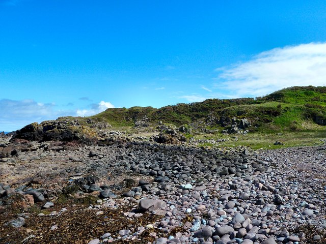
Bradock is a small island located off the coast of Wigtownshire in southwestern Scotland. It covers an area of approximately 2 square miles and is situated within the Irish Sea. The island is largely uninhabited, with only a few scattered cottages and a lighthouse located on its rugged coastline.

The landscape of Bradock is characterized by rocky cliffs, sandy beaches, and rolling hills, providing a diverse and picturesque environment. The island is home to a variety of wildlife, including seabirds, seals, and occasional sightings of dolphins and porpoises in the surrounding waters.

Access to Bradock is mainly by boat, with no regular ferry service available. Visitors can reach the island by private boat or by arranging transportation with local boat operators. The lack of amenities and infrastructure on Bradock makes it a destination suited for those seeking solitude and a remote natural setting.

The island offers opportunities for outdoor activities such as hiking, birdwatching, and photography. The cliffs provide stunning views of the surrounding sea and mainland, while the beaches offer a serene escape for relaxation or exploration. The lighthouse, known as Bradock Point Lighthouse, stands as a historic landmark and can be visited by those interested in its maritime history.

In summary, Bradock is a small, uninhabited island off the coast of Wigtownshire, Scotland. Its rugged coastline, diverse wildlife, and remote setting make it an appealing destination for nature enthusiasts seeking a tranquil escape.

If you have any feedback on the listing, please let us know in the comments section below.

Bradock Images

Images are sourced within 2km of 55.017202/-5.1126064 or Grid Reference NX0173. Thanks to Geograph Open Source API. All images are credited.

Balscalloch Radio Mast Located on Craignawachel at the northern tip of the North Rhins.
Balscalloch Radio Mast
Located on Craignawachel at the northern tip of the North Rhins.
Milleur Point With navigation buoy and Craignawachel communications mast.
Milleur Point
With navigation buoy and Craignawachel communications mast.
 Stena Line Ferry passing Milleur Point Heading into Loch Ryan.
Stena Line Ferry passing Milleur Point
Heading into Loch Ryan.
Port Leen Looking over the bay at Port Lean, glad now I didn't have room for my bucket and spade in my rucksack, although it was suggested that harvesting the seaweed would be a good idea.
Port Leen
Looking over the bay at Port Lean, glad now I didn't have room for my bucket and spade in my rucksack, although it was suggested that harvesting the seaweed would be a good idea.
What comes down, must go up Looking up from Port Leen and the way ahead which will be an uphill climb to get out of the bay and back to the cliff top path to Milleur Point.
What comes down, must go up
Looking up from Port Leen and the way ahead which will be an uphill climb to get out of the bay and back to the cliff top path to Milleur Point.
Port Leen Burn Picture of the burn taken from the nearby cliffs above the bay.
Port Leen Burn
Picture of the burn taken from the nearby cliffs above the bay.
Burn to Sea Watching the Port Leen Burn as it runs into the North Channel near the bay.
Burn to Sea
Watching the Port Leen Burn as it runs into the North Channel near the bay.
Port Leen Burn Waterfall As the burn drops down to the North Channel a waterfall in the foreground runs through the cliffs near the bay.
Port Leen Burn Waterfall
As the burn drops down to the North Channel a waterfall in the foreground runs through the cliffs near the bay.
Burn at Port Leen Looking inland as the burn carves a path through the cliffs down to the bay and North Channel, with Damhouse Hill on the horizon.
Burn at Port Leen
Looking inland as the burn carves a path through the cliffs down to the bay and North Channel, with Damhouse Hill on the horizon.
Waterfall Picture of the Port Leen waterfall marked up on OS Mapping.
Waterfall
Picture of the Port Leen waterfall marked up on OS Mapping.
View to Port Leen Looking west towards Corsewall Point.
View to Port Leen
Looking west towards Corsewall Point.
North Rhinns Coast Looking over the cliffs to the North Channel.
North Rhinns Coast
Looking over the cliffs to the North Channel.
Walking the Cliffs Progress along the cliff tops south of Dundream was slow and challenging with steep drops down to the shore.
Walking the Cliffs
Progress along the cliff tops south of Dundream was slow and challenging with steep drops down to the shore.
Wall to Dundream This stane wall drops down to Dundream from a sheepfold behind the camera.
Wall to Dundream
This stane wall drops down to Dundream from a sheepfold behind the camera.
Derelict Sheepfold Marked on OS Mapping above Dundream this is all the remains of the sheepfold.
Derelict Sheepfold
Marked on OS Mapping above Dundream this is all the remains of the sheepfold.
Red Deer Just visible to the far left of picture is a red deer stag we surprised when walking past this stane wall above Dundream.
Red Deer
Just visible to the far left of picture is a red deer stag we surprised when walking past this stane wall above Dundream.
Dundream View along the north coast of the Rhinns towards the head of Loch Ryan.
Dundream
View along the north coast of the Rhinns towards the head of Loch Ryan.
Show me another place!

Bradock is located at Grid Ref: NX0173 (Lat: 55.017202, Lng: -5.1126064)

Unitary Authority: Dumfries and Galloway

Police Authority: Dumfries and Galloway

What 3 Words

///joystick.sweeper.encourage. Near Cairnryan, Dumfries & Galloway

Related Wikis

Corsewall Point

Corsewall Point, or Corsill Point, is a headland at the northern end of the Rhins of Galloway in Scotland. A lighthouse, Corsewall Lighthouse, was placed...

Kirkcolm

Kirkcolm (Scots: Kirkcoam) is a village and civil parish on the northern tip of the Rhinns of Galloway peninsula, south-west Scotland. It is in Dumfries...

Ervie

Ervie is a small village in Dumfries and Galloway, Scotland, in the Rhins of Galloway, just outside Stranraer.

RAF Wig Bay

Royal Air Force Wig Bay, or more simply RAF Wig Bay, is a former Royal Air Force station near Stranraer, Dumfries and Galloway, Scotland The following...

Nearby Amenities

Located within 500m of 55.017202,-5.1126064
Created By: dmgroom_coastlines
Source: PGS
Lat/Long: 55.017564/-5.105041
Created By: dmgroom_coastlines
Source: PGS
Lat/Long: 55.017789/-5.106836
Created By: dmgroom_coastlines
Source: PGS
Lat/Long: 55.017781/-5.107282
Created By: dmgroom_coastlines
Source: PGS
Lat/Long: 55.017646/-5.10772
Created By: dmgroom_coastlines
Source: PGS
Lat/Long: 55.017134/-5.107693
Created By: dmgroom_coastlines
Source: PGS
Lat/Long: 55.017127/-5.108139
Created By: dmgroom_coastlines
Source: PGS
Lat/Long: 55.017635/-5.108389
Created By: dmgroom_coastlines
Source: PGS
Lat/Long: 55.017887/-5.108625
Created By: dmgroom_coastlines
Source: PGS
Lat/Long: 55.017751/-5.109063
Created By: dmgroom_coastlines
Source: PGS
Lat/Long: 55.017615/-5.109502
Created By: dmgroom_coastlines
Source: PGS
Lat/Long: 55.017104/-5.109475
Created By: dmgroom_coastlines
Source: PGS
Lat/Long: 55.017096/-5.109921
Created By: dmgroom_coastlines
Source: PGS
Lat/Long: 55.017608/-5.109947
Created By: dmgroom_coastlines
Source: PGS
Lat/Long: 55.017472/-5.110386
Created By: dmgroom_coastlines
Source: PGS
Lat/Long: 55.017208/-5.110818
Created By: dmgroom_coastlines
Source: PGS
Lat/Long: 55.016929/-5.112141
Created By: dmgroom_coastlines
Source: PGS
Lat/Long: 55.016665/-5.112573
Created By: dmgroom_coastlines
Source: PGS
Lat/Long: 55.016401/-5.113005
Created By: dmgroom_coastlines
Source: PGS
Lat/Long: 55.016394/-5.11345
Created By: dmgroom_coastlines
Source: PGS
Lat/Long: 55.016386/-5.113896
Created By: dmgroom_coastlines
Source: PGS
Lat/Long: 55.016251/-5.114334
Created By: dmgroom_coastlines
Source: PGS
Lat/Long: 55.015739/-5.114307
Created By: dmgroom_coastlines
Source: PGS
Lat/Long: 55.015851/-5.115205
Created By: dmgroom_coastlines
Source: PGS
Lat/Long: 55.015843/-5.11565
Created By: dmgroom_coastlines
Source: PGS
Lat/Long: 55.015708/-5.116089
Created By: dmgroom_coastlines
Source: PGS
Lat/Long: 55.015192/-5.116286
Created By: dmgroom_coastlines
Source: PGS
Lat/Long: 55.014932/-5.116494
Created By: dmgroom_coastlines
Source: PGS
Lat/Long: 55.014788/-5.117378
Created By: dmgroom_coastlines
Source: PGS
Lat/Long: 55.014645/-5.118262
Created By: dmgroom_coastlines
Source: PGS
Lat/Long: 55.014133/-5.118235
The data included in this document is from www.openstreetmap.org. The data is made available under ODbL.

Have you been to Bradock?

Leave your review of Bradock below (or comments, questions and feedback).