Aber Ceffyl

Bay in Pembrokeshire

Wales

Aber Ceffyl

Make Hay. Pwll-caerog, looking across the fields from the Pembrokeshire Coast Path.
Make Hay. Credit: Chris McAuley

Aber Ceffyl, located in Pembrokeshire, is a small bay situated on the west coast of Wales, known for its stunning natural beauty and rich historical significance. The name Aber Ceffyl translates to "horse estuary" in Welsh, highlighting its connection to the equestrian heritage of the area.

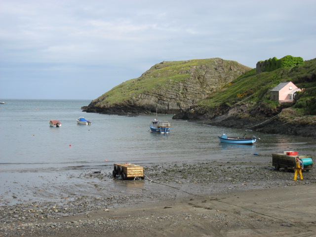
The bay is characterized by its picturesque sandy beach, which stretches for approximately 1.5 kilometers and is backed by towering cliffs. The beach is a popular destination for locals and tourists alike, offering opportunities for sunbathing, picnicking, and leisurely walks along the shoreline. The crystal-clear waters of Aber Ceffyl are ideal for swimming, and the bay attracts water sports enthusiasts who enjoy activities such as surfing, kayaking, and paddleboarding.

Aber Ceffyl is also renowned for its diverse wildlife. The bay is a designated Special Area of Conservation due to its importance as a habitat for various marine species, including seals and dolphins. Birdwatchers flock to the area to catch a glimpse of the numerous seabirds that inhabit the cliffs surrounding the bay.

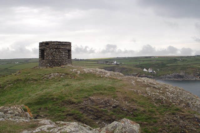
From a historical perspective, Aber Ceffyl has played a significant role in Welsh maritime heritage. The bay was once a bustling fishing port, and remnants of its industrial past can still be seen in the form of old stone quays and fisherman's cottages. Today, the bay offers a glimpse into its history through the Aber Ceffyl Heritage Trail, which guides visitors through the area's past.

Overall, Aber Ceffyl is a captivating destination that combines natural beauty, outdoor activities, and a rich historical legacy, making it an appealing location for those seeking a coastal retreat in Pembrokeshire.

If you have any feedback on the listing, please let us know in the comments section below.

Aber Ceffyl Images

Images are sourced within 2km of 51.928998/-5.2355211 or Grid Reference SM7730. Thanks to Geograph Open Source API. All images are credited.

Make Hay. Pwll-caerog, looking across the fields from the Pembrokeshire Coast Path.
Make Hay.
Pwll-caerog, looking across the fields from the Pembrokeshire Coast Path.
Aber Pwll
Aber Pwll
Porth Tre-wen
Porth Tre-wen
Abereiddy Tower Situated on the Trwyncastell headland to the north of Abereiddi Bay. This tower, of uncertain usage (local information board suggests possibility of it being a meeting place for directors of the now defunct Abereiddy Slate Mine, or their ladies), lies just off the Pembrokeshire Coastal Path and gets comparatively few visitors. This is possibly because a "scramble" is required to access the headland, as coastal erosion is steadily severing the headland's link with the main peninsula.
Abereiddy Tower
Situated on the Trwyncastell headland to the north of Abereiddi Bay. This tower, of uncertain usage (local information board suggests possibility of it being a meeting place for directors of the now defunct Abereiddy Slate Mine, or their ladies), lies just off the Pembrokeshire Coastal Path and gets comparatively few visitors. This is possibly because a "scramble" is required to access the headland, as coastal erosion is steadily severing the headland's link with the main peninsula.
Abereiddi Bay
Abereiddi Bay
Stonechat The European Stonechat (Saxicola rubicola) breed in heathland, coastal dunes and rough grassland with scattered small shrubs and bramble, open gorse, tussocks or heather. The male's song is high and twittering like a Dunnock. Both sexes have a clicking call like stones knocking together.
Stonechat
The European Stonechat (Saxicola rubicola) breed in heathland, coastal dunes and rough grassland with scattered small shrubs and bramble, open gorse, tussocks or heather. The male's song is high and twittering like a Dunnock. Both sexes have a clicking call like stones knocking together.
Porth Tre-wen Taken from the coastal path
Porth Tre-wen
Taken from the coastal path
Castell Coch Fort
Castell Coch Fort
Ynys Gwair
Ynys Gwair
Bluebell Covered Clifftops
Aber-pwll
Aber-pwll
Caer Aber Pwll (Caerau) Iron Age Fort The complex defences at Caer Aber Pwll (Caerau) define a simple promontory fort to the east and a more heavily defended promontory fort on the west, both utilising the defensive potentials of the steep coastal cliffs. The western fort contains at least one building platform and is enclosed by a complex of up to four banks and ditches thought to represent at least two periods of construction, of uncertain relation, extending over a roughly 172m front. The main, inturned, gateway can be made out on the far side of the earthworks.

A second enclosure on the east, about 48m by 34m, may be a fragment of an early enclosure, isolated by redevelopment, an annex, or a separate and later enclosure butting onto the primary work.
Caer Aber Pwll (Caerau) Iron Age Fort
The complex defences at Caer Aber Pwll (Caerau) define a simple promontory fort to the east and a more heavily defended promontory fort on the west, both utilising the defensive potentials of the steep coastal cliffs. The western fort contains at least one building platform and is enclosed by a complex of up to four banks and ditches thought to represent at least two periods of construction, of uncertain relation, extending over a roughly 172m front. The main, inturned, gateway can be made out on the far side of the earthworks. A second enclosure on the east, about 48m by 34m, may be a fragment of an early enclosure, isolated by redevelopment, an annex, or a separate and later enclosure butting onto the primary work.
Pembrokeshire Coastal Path
Cliffs from the Coast Path Jagged steep cliffs and calm seas near Abereiddi.
Cliffs from the Coast Path
Jagged steep cliffs and calm seas near Abereiddi.
Aber-pwll A view over this rocky coastal inlet.
Aber-pwll
A view over this rocky coastal inlet.
Aber-pwll View out to Sea
Thrift on a clifftop wall Clifftop field walls such as this are the classic place to find the coastal plant known as Thrift or Sea Pink.
Thrift on a clifftop wall
Clifftop field walls such as this are the classic place to find the coastal plant known as Thrift or Sea Pink.
Ynys Gwair and the Clifftop at Castell Coch Ynys Gwair is the offshore island with the much smaller Carreg-gwylan-fach just beyond.
Ynys Gwair and the Clifftop at Castell Coch
Ynys Gwair is the offshore island with the much smaller Carreg-gwylan-fach just beyond.
Show me another place!

Aber Ceffyl is located at Grid Ref: SM7730 (Lat: 51.928998, Lng: -5.2355211)

Unitary Authority: Pembrokeshire

Police Authority: Dyfed Powys

What 3 Words

///scrolled.welcome.wand. Near Llanrhian, Pembrokeshire

Related Wikis

Arfordir Abereiddi

Arfordir Abereiddi is a Site of Special Scientific Interest (SSSI) in Pembrokeshire, South Wales. It has been designated as a Site of Special Scientific...

Abereiddy

Abereiddy (Welsh: Abereddi) is a hamlet in the county of Pembrokeshire, in west Wales.It has a small beach which was awarded the Blue flag rural beach...

Portheiddy Moor

Portheiddy Moor is a Site of Special Scientific Interest (or SSSI) a little to the east of Abereiddy in Pembrokeshire, South Wales. It has been designated...

Dowrog Common

Dowrog Common (Welsh: Comin Dowrog) is a Site of Special Scientific Interest (or SSSI) in Pembrokeshire, South Wales. It has been designated as a Site...

Have you been to Aber Ceffyl?

Leave your review of Aber Ceffyl below (or comments, questions and feedback).