Aberdinas

Bay in Pembrokeshire

Wales

Aberdinas

Make Hay. Pwll-caerog, looking across the fields from the Pembrokeshire Coast Path.
Make Hay. Credit: Chris McAuley

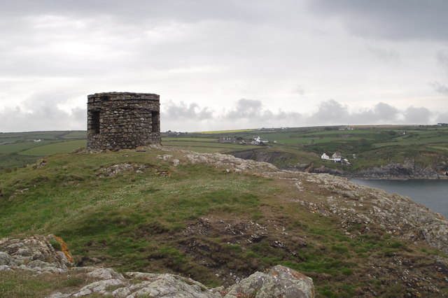
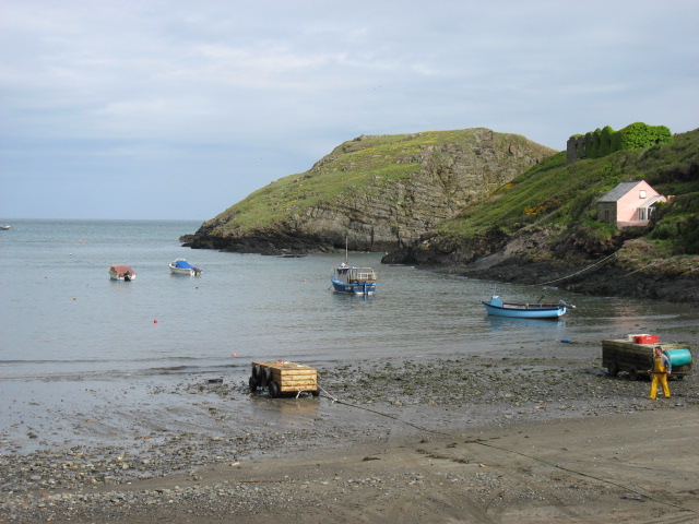
Aberdinas is a picturesque bay located in the county of Pembrokeshire, Wales. Situated on the western coast of the country, it offers stunning natural beauty and a peaceful retreat for visitors. The bay is nestled between towering cliffs and rolling hills, providing a dramatic backdrop to its pristine sandy beach.

The bay is known for its crystal-clear waters and is a popular spot for various water activities such as swimming, snorkeling, and kayaking. The beach is also perfect for sunbathing and picnicking, with ample space for families and friends to relax and enjoy the surroundings.

Aberdinas is home to a rich array of wildlife, making it an ideal destination for nature enthusiasts. Birdwatchers can spot a variety of seabirds, including gulls, cormorants, and even the occasional puffin. The bay is also frequented by seals and dolphins, adding to its charm and appeal.

For those who enjoy hiking and exploring, Aberdinas offers several coastal walking paths that provide breathtaking views of the bay and its surroundings. The nearby cliffs provide opportunities for rock climbing and offer panoramic vistas of the rugged coastline.

Although relatively secluded, Aberdinas is not far from the town of Fishguard, where visitors can find amenities such as shops, restaurants, and accommodations. The bay's tranquil atmosphere and natural beauty make it a hidden gem for those seeking a peaceful getaway in Pembrokeshire.

If you have any feedback on the listing, please let us know in the comments section below.

Aberdinas Images

Images are sourced within 2km of 51.92839/-5.2363648 or Grid Reference SM7730. Thanks to Geograph Open Source API. All images are credited.

Make Hay. Pwll-caerog, looking across the fields from the Pembrokeshire Coast Path.
Make Hay.
Pwll-caerog, looking across the fields from the Pembrokeshire Coast Path.
Aber Pwll
Aber Pwll
Porth Tre-wen
Porth Tre-wen
Abereiddy Tower Situated on the Trwyncastell headland to the north of Abereiddi Bay. This tower, of uncertain usage (local information board suggests possibility of it being a meeting place for directors of the now defunct Abereiddy Slate Mine, or their ladies), lies just off the Pembrokeshire Coastal Path and gets comparatively few visitors. This is possibly because a "scramble" is required to access the headland, as coastal erosion is steadily severing the headland's link with the main peninsula.
Abereiddy Tower
Situated on the Trwyncastell headland to the north of Abereiddi Bay. This tower, of uncertain usage (local information board suggests possibility of it being a meeting place for directors of the now defunct Abereiddy Slate Mine, or their ladies), lies just off the Pembrokeshire Coastal Path and gets comparatively few visitors. This is possibly because a "scramble" is required to access the headland, as coastal erosion is steadily severing the headland's link with the main peninsula.
Abereiddi Bay
Abereiddi Bay
Stonechat The European Stonechat (Saxicola rubicola) breed in heathland, coastal dunes and rough grassland with scattered small shrubs and bramble, open gorse, tussocks or heather. The male's song is high and twittering like a Dunnock. Both sexes have a clicking call like stones knocking together.
Stonechat
The European Stonechat (Saxicola rubicola) breed in heathland, coastal dunes and rough grassland with scattered small shrubs and bramble, open gorse, tussocks or heather. The male's song is high and twittering like a Dunnock. Both sexes have a clicking call like stones knocking together.
Porth Tre-wen Taken from the coastal path
Porth Tre-wen
Taken from the coastal path
Castell Coch Fort
Castell Coch Fort
Ynys Gwair
Ynys Gwair
Bluebell Covered Clifftops
Aber-pwll
Aber-pwll
Caer Aber Pwll (Caerau) Iron Age Fort The complex defences at Caer Aber Pwll (Caerau) define a simple promontory fort to the east and a more heavily defended promontory fort on the west, both utilising the defensive potentials of the steep coastal cliffs. The western fort contains at least one building platform and is enclosed by a complex of up to four banks and ditches thought to represent at least two periods of construction, of uncertain relation, extending over a roughly 172m front. The main, inturned, gateway can be made out on the far side of the earthworks.

A second enclosure on the east, about 48m by 34m, may be a fragment of an early enclosure, isolated by redevelopment, an annex, or a separate and later enclosure butting onto the primary work.
Caer Aber Pwll (Caerau) Iron Age Fort
The complex defences at Caer Aber Pwll (Caerau) define a simple promontory fort to the east and a more heavily defended promontory fort on the west, both utilising the defensive potentials of the steep coastal cliffs. The western fort contains at least one building platform and is enclosed by a complex of up to four banks and ditches thought to represent at least two periods of construction, of uncertain relation, extending over a roughly 172m front. The main, inturned, gateway can be made out on the far side of the earthworks. A second enclosure on the east, about 48m by 34m, may be a fragment of an early enclosure, isolated by redevelopment, an annex, or a separate and later enclosure butting onto the primary work.
Pembrokeshire Coastal Path
Cliffs from the Coast Path Jagged steep cliffs and calm seas near Abereiddi.
Cliffs from the Coast Path
Jagged steep cliffs and calm seas near Abereiddi.
Aber-pwll A view over this rocky coastal inlet.
Aber-pwll
A view over this rocky coastal inlet.
Aber-pwll View out to Sea
Thrift on a clifftop wall Clifftop field walls such as this are the classic place to find the coastal plant known as Thrift or Sea Pink.
Thrift on a clifftop wall
Clifftop field walls such as this are the classic place to find the coastal plant known as Thrift or Sea Pink.
Ynys Gwair and the Clifftop at Castell Coch Ynys Gwair is the offshore island with the much smaller Carreg-gwylan-fach just beyond.
Ynys Gwair and the Clifftop at Castell Coch
Ynys Gwair is the offshore island with the much smaller Carreg-gwylan-fach just beyond.
Show me another place!

Aberdinas is located at Grid Ref: SM7730 (Lat: 51.92839, Lng: -5.2363648)

Unitary Authority: Pembrokeshire

Police Authority: Dyfed Powys

What 3 Words

///polar.decking.talkers. Near Llanrhian, Pembrokeshire

Related Wikis

Arfordir Abereiddi

Arfordir Abereiddi is a Site of Special Scientific Interest (SSSI) in Pembrokeshire, South Wales. It has been designated as a Site of Special Scientific...

Abereiddy

Abereiddy (Welsh: Abereddi) is a hamlet in the county of Pembrokeshire, in west Wales.It has a small beach which was awarded the Blue flag rural beach...

Portheiddy Moor

Portheiddy Moor is a Site of Special Scientific Interest (or SSSI) a little to the east of Abereiddy in Pembrokeshire, South Wales. It has been designated...

Dowrog Common

Dowrog Common (Welsh: Comin Dowrog) is a Site of Special Scientific Interest (or SSSI) in Pembrokeshire, South Wales. It has been designated as a Site...

Have you been to Aberdinas?

Leave your review of Aberdinas below (or comments, questions and feedback).