Barton-under-Needwood

Settlement in Staffordshire East Staffordshire

England

Barton-under-Needwood

The Barton Turns Inn This public house lies on the Barton Turn road, between the A38 and the Trent and Mersey canal. The Way for the Millennium passes in front of this Inn.
The Barton Turns Inn Credit: Mick Malpass

Barton-under-Needwood is a picturesque village located in the county of Staffordshire, England. Situated on the eastern bank of the River Trent, it lies approximately 7 miles southwest of Burton upon Trent and 7 miles northeast of Rugeley. The village is nestled in the heart of the National Forest, a designated area of outstanding natural beauty.

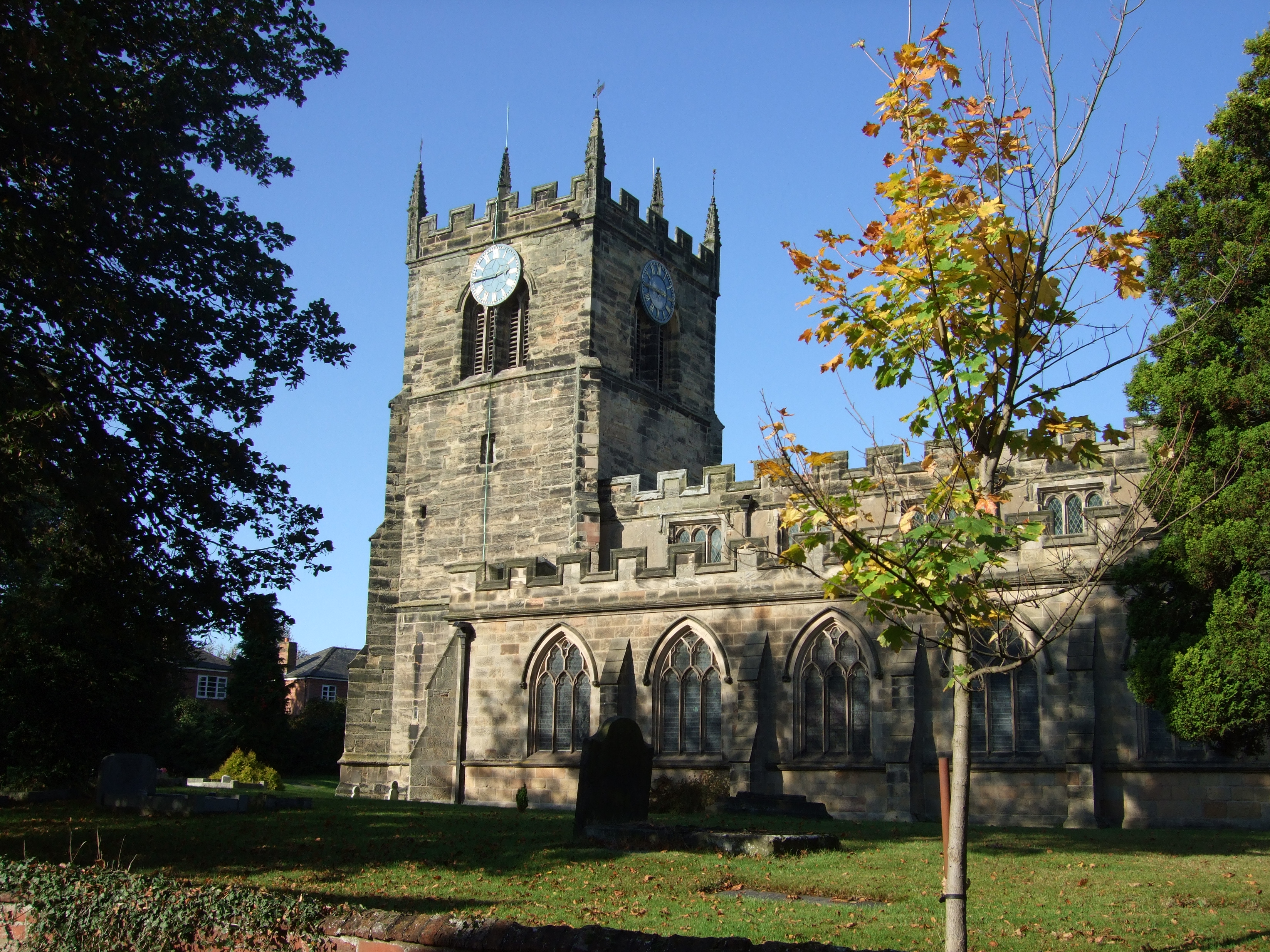
With a population of around 2,000 residents, Barton-under-Needwood is known for its charming and traditional English village atmosphere. The village center features a mix of historic buildings, including the Grade II listed St. James' Church, which dates back to the 13th century. The local primary school, Barton-under-Needwood CofE, is highly regarded for its academic standards and strong sense of community.

The village offers a range of amenities, including several pubs, restaurants, and small shops, catering to both locals and visitors. Barton Marina, located on the outskirts of the village, is a popular attraction, offering a variety of leisure activities such as boating and fishing. The marina also boasts a selection of shops, cafes, and a cinema, adding to the village's appeal.

Surrounded by beautiful countryside, Barton-under-Needwood offers ample opportunities for outdoor pursuits. The National Forest provides scenic walking and cycling trails, while the nearby Cannock Chase Area of Outstanding Natural Beauty offers further opportunities for exploration.

Overall, Barton-under-Needwood is a charming village, combining a rich history, natural beauty, and a strong community spirit, making it an idyllic place to live or visit in Staffordshire.

If you have any feedback on the listing, please let us know in the comments section below.

Barton-under-Needwood Images

Images are sourced within 2km of 52.765208/-1.72573 or Grid Reference SK1818. Thanks to Geograph Open Source API. All images are credited.

The Barton Turns Inn This public house lies on the Barton Turn road, between the A38 and the Trent and Mersey canal. The Way for the Millennium passes in front of this Inn.
The Barton Turns Inn
This public house lies on the Barton Turn road, between the A38 and the Trent and Mersey canal. The Way for the Millennium passes in front of this Inn.
The Wharf House, Barton Turn
Wharf House chimney stack at Barton Turn, Staffordshire Two types of chimney pot are shown on this large 18th century Grade II listed house by the Trent and Mersey Canal.
Wharf House chimney stack at Barton Turn, Staffordshire
Two types of chimney pot are shown on this large 18th century Grade II listed house by the Trent and Mersey Canal.
Central Rivers railway depot Showing part of the locomotive maintenance depot completed in 2001. "Purposefully located near a number of major cross-country train routes, the depots facilities of inspection and working pits, hoisting facilities, train washing and refuelling is designed for a planned turnaround of up to twenty serviced trains per night" <span class="nowrap"><a title="http://en.wikipedia.org/wiki/Central_Rivers_TMD" rel="nofollow ugc noopener" href="http://en.wikipedia.org/wiki/Central_Rivers_TMD">Link</a><img style="margin-left:2px;" alt="External link" title="External link - shift click to open in new window" src="https://s1.geograph.org.uk/img/external.png" width="10" height="10"/></span> . View from a train travelling between Burton and Lichfield.
Central Rivers railway depot
Showing part of the locomotive maintenance depot completed in 2001. "Purposefully located near a number of major cross-country train routes, the depots facilities of inspection and working pits, hoisting facilities, train washing and refuelling is designed for a planned turnaround of up to twenty serviced trains per night" LinkExternal link . View from a train travelling between Burton and Lichfield.
Industrial building, Barton Turn
The Barton Parish milepost in its setting The southbound carriageway of the A38 at Barton Turn, where the Barton Parish milepost survives , somehow, with traffic tearing past it at 70mph and more. A rather alarming place to sit in the central reservation and take a photo too, to be frank. Detail of the milepost at <a href="https://www.geograph.org.uk/photo/3658736">SK2018 : The Barton Parish milepost - detail</a>
The Barton Parish milepost in its setting
The southbound carriageway of the A38 at Barton Turn, where the Barton Parish milepost survives , somehow, with traffic tearing past it at 70mph and more. A rather alarming place to sit in the central reservation and take a photo too, to be frank. Detail of the milepost at SK2018 : The Barton Parish milepost - detail
The Barton Parish milepost - detail A cast-iron milepost which presumably once sat beside the old road, and has been relocated to the verge of the dual carriageway. It scared me silly to stand in the southbound road, even for 10 seconds, to take this photo; shan't be doing that too often.
The Barton Parish milepost - detail
A cast-iron milepost which presumably once sat beside the old road, and has been relocated to the verge of the dual carriageway. It scared me silly to stand in the southbound road, even for 10 seconds, to take this photo; shan't be doing that too often.
Wharfe House, Barton Turn by Barton Turn Lock, Trent and Mersey Canal Grade II 18th century House.
Wharfe House, Barton Turn by Barton Turn Lock, Trent and Mersey Canal
Grade II 18th century House.
Approaching Barton & Walton An unidentified class 47 locomotive brings a freight northeast along the Birmingham to Derby main line which neatly bisects the towns of Barton-under-Needwood and Walton-upon-Trent at this point.   The view is taken from the B5016, Station Lane and shows the open farmland before the construction of Barton Business Park and the Bombardier Transportation Depot.
Approaching Barton & Walton
An unidentified class 47 locomotive brings a freight northeast along the Birmingham to Derby main line which neatly bisects the towns of Barton-under-Needwood and Walton-upon-Trent at this point. The view is taken from the B5016, Station Lane and shows the open farmland before the construction of Barton Business Park and the Bombardier Transportation Depot.
Site of Ryknild Street Roman road at Barton Turns Former A38 north of junction, now bypassed. Modern tarmac above the roman remains.
Site of Ryknild Street Roman road at Barton Turns
Former A38 north of junction, now bypassed. Modern tarmac above the roman remains.
Barton Turn Bridge No 37A Carrying an access road to and from the A38 across the Trent & Mersey Canal. On the right is one of the Trent & Mersey Canal Mileposts.
<a href="https://www.geograph.org.uk/photo/4544539">SK2019 : Trent & Mersey Canal Milepost</a>, for the previous milepost.
<a href="https://www.geograph.org.uk/photo/4546039">SK1917 : Trent & Mersey Canal Milepost</a>, for the next milepost along the canal.
Barton Turn Bridge No 37A
Carrying an access road to and from the A38 across the Trent & Mersey Canal. On the right is one of the Trent & Mersey Canal Mileposts. SK2019 : Trent & Mersey Canal Milepost, for the previous milepost. SK1917 : Trent & Mersey Canal Milepost, for the next milepost along the canal.
Station Road Bridge No 37B Crossing the Trent & Mersey Canal at Barton Turn.
Station Road Bridge No 37B
Crossing the Trent & Mersey Canal at Barton Turn.
Wharf House at Barton Turn Next to Barton Turn Bridge and Lock along the Trent & Mersey Canal.
Wharf House at Barton Turn
Next to Barton Turn Bridge and Lock along the Trent & Mersey Canal.
Barton Turn next to the Trent & Mersey Canal Looking towards the Barton Turns Inn.
Barton Turn next to the Trent & Mersey Canal
Looking towards the Barton Turns Inn.
Postbox and Wharf House at Barton Turn Next to Barton Turn Bridge No 38 along the Trent & Mersey Canal.
Postbox and Wharf House at Barton Turn
Next to Barton Turn Bridge No 38 along the Trent & Mersey Canal.
Barton Turn Lock No 10 Next to Barton Turn Bridge No 38 along the Trent & Mersey Canal.
Barton Turn Lock No 10
Next to Barton Turn Bridge No 38 along the Trent & Mersey Canal.
Trent & Mersey Canal at Barton Turn Looking towards Barton Turn Lock No 10 and Wharf House.
Trent & Mersey Canal at Barton Turn
Looking towards Barton Turn Lock No 10 and Wharf House.
Barton junction from A38
Show me another place!

Barton-under-Needwood is located at Grid Ref: SK1818 (Lat: 52.765208, Lng: -1.72573)

Administrative County: Staffordshire

District: East Staffordshire

Police Authority: Staffordshire

What 3 Words

///grips.bridge.email. Near Barton under Needwood, Staffordshire

Related Wikis

Barton-under-Needwood

Barton-under-Needwood is a large village in the East Staffordshire district of Staffordshire, England. Situated a mile from the A38, and located between...

John Taylor High School

John Taylor High School is a specialist science and leadership academy located in the East Staffordshire village of Barton-under-Needwood, near Burton...

Barton Gate

Barton Gate is a village in Staffordshire, England.For population details at the 2011 census see Barton-under-Needwood.
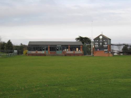
Deer Park, Dunstall

Deer Park is a cricket ground within the grounds of Dunstall Hall, Dunstall, Staffordshire. The first recorded match on the ground was in 1997, when the...

Barton Green

Barton Green is a village in Staffordshire, England. For population details taken at the 2011 census see Barton-under-Needwood

Dunstall

Dunstall is a small village and civil parish in the borough of East Staffordshire, Staffordshire, England. It lies between Burton upon Trent and Barton...

Central Rivers TMD

Central Rivers TMD (also known as Barton-under-Needwood CMD) is a railway maintenance depot, located in Barton-under-Needwood, 4 miles (6 km) south-west...
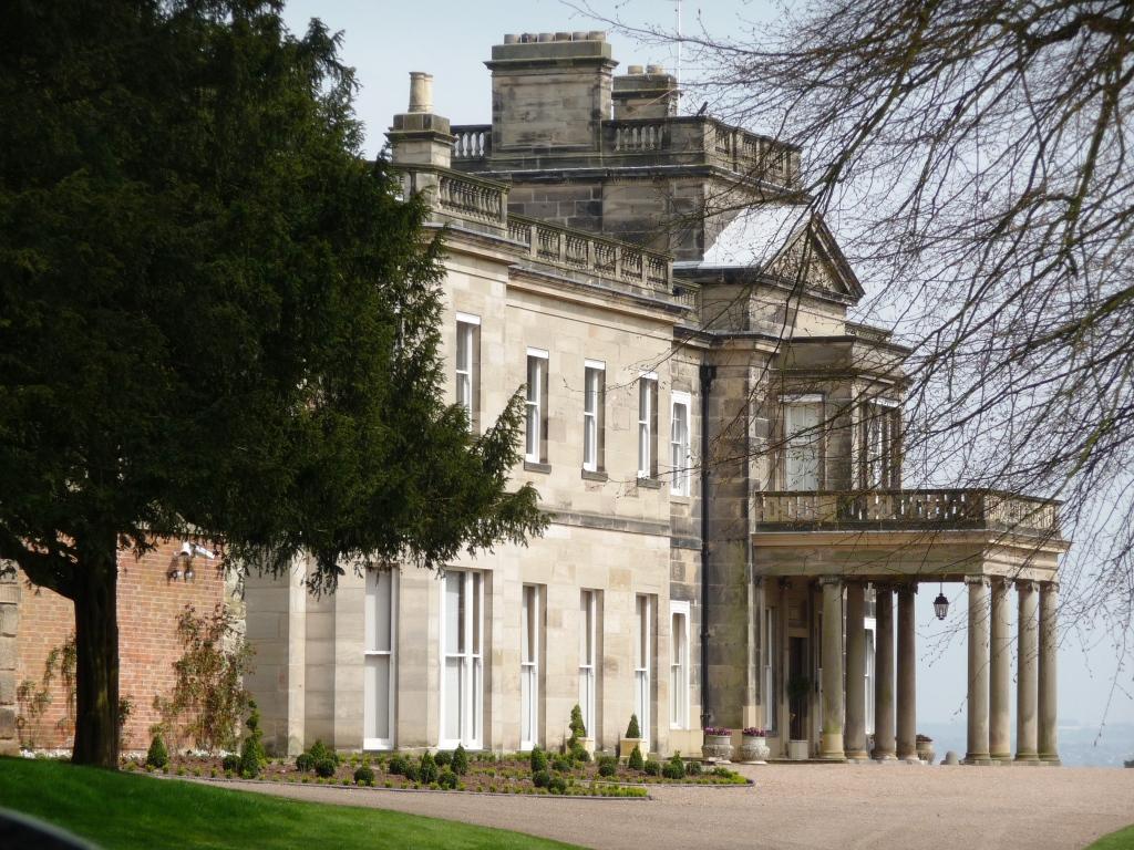
Dunstall Hall

Dunstall Hall is a privately owned 18th century mansion house near Tatenhill, Burton upon Trent, Staffordshire. It is a Grade II* listed building. �...

Related Videos

Barton marina visit

We travelled to Barton Marina which is a genuinely nice area in the village Barton-under-Needwood, in Staffordshire, in the heart ...

Barton marina hidden gem 🚤❤️

Great little marina relaxed atmosphere Good amenities. All you need for a relaxing morning or afternoon out # Bartonmarina ...

National Forest Way Escapades: The Adventure Continues

For lovers of English forests and woodlands, the the National Forest Way is a must to experience. It's a long distance path first ...

Nearby Amenities

Located within 500m of 52.765208,-1.72573
Note: Road name changes
Lat/Long: 52.761493/-1.7270959
Mini Roundabout
Direction: clockwise
Lat/Long: 52.7635114/-1.7207911
Crossing
Crossing: unmarked
Crossing Island: no
Tactile Paving: no
Lat/Long: 52.7616046/-1.7286011
Turning Circle
Lat/Long: 52.7613387/-1.7291356
St James Hall
Building: public
Lat/Long: 52.7633186/-1.7220253
Barrier: cycle_barrier
Bicycle: dismount
Cycle Barrier: double
Cycle Barrier Installation: fixed
Wheelchair: yes
Lat/Long: 52.7635739/-1.7238673
Access: yes
Barrier: bollard
Bicycle: yes
Bollard: removable
Foot: yes
Horse: yes
Material: wood
Vehicle: private
Lat/Long: 52.7646189/-1.7230973
Traffic Calming: chicane
Lat/Long: 52.7625723/-1.7247305
Turning Circle
Lat/Long: 52.7624549/-1.7218644
Power: substation
Source: approx
Lat/Long: 52.7618977/-1.7225603
Disused Amenity: post_box
Post Box Type: wall
Postal Code: DE13
Ref: DE13 1078
Royal Cypher: GR
Lat/Long: 52.7614733/-1.7272162
Toilets
Check Date: 2022-08-29
Fee: no
Source: approx
Lat/Long: 52.7655925/-1.7245554
Post Box
Collection Times: Mo-Fr 17:00; Sa 10:30
Postal Code: DE13
Ref: DE13 1125
Lat/Long: 52.765167/-1.724627
Radhurst Farm
Note: road leads to
Lat/Long: 52.7664545/-1.724004
Pub
Red Lion
Addr City: Burton-on-Trent
Addr Housenumber: 47
Addr Postcode: DE13 8AA
Addr Street: Main Street
Addr Village: Barton-under-Needwood
Fhrs Id: 1683912
Source: approx
Lat/Long: 52.7651006/-1.7255337
Barton-under-Needwood
Is In Country: UK
Place: village
Lat/Long: 52.7641837/-1.7226049
Grit Bin
Lat/Long: 52.7646028/-1.7193999
Barrier: bollard
Bollard: fixed
Lat/Long: 52.7635832/-1.7254345
Tourism: picnic_site
Lat/Long: 52.7641947/-1.7219233
Historic: monument
Lat/Long: 52.7639857/-1.7220575
Historic: memorial
Lat/Long: 52.7657646/-1.7202912
Crossing
Crossing: uncontrolled
Crossing Island: no
Crossing Markings: zebra
Tactile Paving: yes
Lat/Long: 52.765075/-1.7245154
Dunstall Estate
Information: map
Tourism: information
Lat/Long: 52.7675342/-1.7239194
Dunstall Estate
Tourism: information
Lat/Long: 52.767908/-1.7208884
Post Office
Barton-under-Needwood Post Office
Addr City: Burton-on-Trent
Addr Housenumber: 60
Addr Postcode: DE13 8AA
Addr Street: Main Street
Addr Village: Barton-under-Needwood
Brand: Post Office
Brand Wikidata: Q1783168
Ref Pol Id: 13742
Website: https://www.postoffice.co.uk/branch-finder/3592073/barton-under-needwood
Lat/Long: 52.7651911/-1.7245521
Bus Stop
No. 17
Naptan AtcoCode: 3800C344601
Naptan NaptanCode: stadjadg
Public Transport: platform
Lat/Long: 52.7646121/-1.7261007
Bus Stop
No. 17
Public Transport: platform
Lat/Long: 52.7650179/-1.7259049
Bus Stop
Brookside Road
Bench: no
Bin: yes
Naptan AtcoCode: 3800C344502
Naptan NaptanCode: stadjada
Public Transport: platform
Shelter: no
Tactile Paving: no
Lat/Long: 52.7635255/-1.726715
Bus Stop
Brookside Road
Bench: no
Bin: no
Lit: yes
Naptan AtcoCode: 3800C344501
Naptan NaptanCode: stadgwtw
Public Transport: platform
Shelter: no
Tactile Paving: no
Lat/Long: 52.7631027/-1.72666
Bus Stop
Short Lane
Bench: no
Bin: no
Bus: yes
Naptan AtcoCode: 3800C324601
Naptan NaptanCode: stadgdtm
Public Transport: platform
Shelter: no
Tactile Paving: no
Lat/Long: 52.7618205/-1.727057
Bus Stop
Short Lane
Bus: yes
Public Transport: platform
Lat/Long: 52.7610796/-1.7274955
Bus Stop
Park Road
Naptan AtcoCode: 3800C344302
Naptan NaptanCode: stadgwtj
Public Transport: platform
Lat/Long: 52.7659259/-1.7286783
Bus Stop
Park Road
Naptan AtcoCode: 3800C344301
Naptan NaptanCode: stadgwtg
Public Transport: platform
Lat/Long: 52.7659259/-1.7292134
Bus Stop
St James' Church
Naptan AtcoCode: 3800C335802
Naptan NaptanCode: stadgpwa
Public Transport: platform
Lat/Long: 52.7644498/-1.7226326
Bus Stop
St James' Church
Naptan AtcoCode: 3800C335801
Naptan NaptanCode: stadgptw
Public Transport: platform
Lat/Long: 52.7644969/-1.722583
Bus Stop
John Taylor High School
Naptan AtcoCode: 3800C311900
Public Transport: platform
Lat/Long: 52.7648511/-1.7210475
Bus Stop
Barton Lodge
Naptan AtcoCode: 3800C344701
Naptan NaptanCode: stadjadm
Public Transport: platform
Lat/Long: 52.7633997/-1.7200457
Bus Stop
Barton Lodge
Naptan AtcoCode: 3800C344702
Naptan NaptanCode: stadjadp
Public Transport: platform
Lat/Long: 52.7633072/-1.7197292
Direction: 195
Generator Method: photovoltaic
Generator Output Electricity: yes
Generator Solar Modules: 7
Generator Source: solar
Generator Type: solar_photovoltaic_panel
Location: roof
Power: generator
Lat/Long: 52.7644278/-1.7291341
Direction: 195
Generator Method: photovoltaic
Generator Output Electricity: yes
Generator Solar Modules: 3
Generator Source: solar
Generator Type: solar_photovoltaic_panel
Location: roof
Power: generator
Lat/Long: 52.7644192/-1.7290516
Direction: 195
Generator Method: photovoltaic
Generator Output Electricity: yes
Generator Solar Modules: 5
Generator Source: solar
Generator Type: solar_photovoltaic_panel
Location: roof
Power: generator
Lat/Long: 52.7643095/-1.7286768
Direction: 195
Generator Method: photovoltaic
Generator Output Electricity: yes
Generator Solar Modules: 3
Generator Source: solar
Generator Type: solar_photovoltaic_panel
Location: roof
Power: generator
Lat/Long: 52.7642913/-1.728595
Direction: 105
Generator Method: photovoltaic
Generator Output Electricity: yes
Generator Solar Modules: 4
Generator Source: solar
Generator Type: solar_photovoltaic_panel
Location: roof
Power: generator
Lat/Long: 52.7642604/-1.7286258
Direction: 285
Generator Method: photovoltaic
Generator Output Electricity: yes
Generator Solar Modules: 4
Generator Source: solar
Generator Type: solar_photovoltaic_panel
Location: roof
Power: generator
Lat/Long: 52.7642685/-1.7286741
Direction: 105
Generator Method: photovoltaic
Generator Output Electricity: yes
Generator Solar Modules: 4
Generator Source: solar
Generator Type: solar_photovoltaic_panel
Location: roof
Power: generator
Lat/Long: 52.7641852/-1.7282041
Kerb: raised
Lat/Long: 52.7634694/-1.7292548
Direction: 190
Generator Method: photovoltaic
Generator Output Electricity: yes
Generator Solar Modules: 12
Generator Source: solar
Generator Type: solar_photovoltaic_panel
Location: roof
Power: generator
Lat/Long: 52.7616981/-1.7284374
Kerb: raised
Lat/Long: 52.7618999/-1.7301442
Direction: SE
Generator Method: photovoltaic
Generator Output Electricity: yes
Generator Solar Modules: 7
Generator Source: solar
Generator Type: solar_photovoltaic_panel
Location: roof
Power: generator
Lat/Long: 52.7653705/-1.7316059
Direction: SE
Generator Method: photovoltaic
Generator Output Electricity: yes
Generator Solar Modules: 7
Generator Source: solar
Generator Type: solar_photovoltaic_panel
Location: roof
Power: generator
Lat/Long: 52.7654058/-1.7315438
Direction: S
Generator Method: photovoltaic
Generator Output Electricity: yes
Generator Solar Modules: 12
Generator Source: solar
Generator Type: solar_photovoltaic_panel
Location: roof
Power: generator
Lat/Long: 52.7658297/-1.7291992
Direction: 195
Generator Method: photovoltaic
Generator Output Electricity: yes
Generator Solar Modules: 12
Generator Source: solar
Generator Type: solar_photovoltaic_panel
Location: roof
Power: generator
Lat/Long: 52.7630829/-1.7269901
Direction: SSW
Generator Method: photovoltaic
Generator Output Electricity: yes
Generator Solar Modules: 16
Generator Source: solar
Generator Type: solar_photovoltaic_panel
Location: roof
Power: generator
Lat/Long: 52.7607218/-1.725808
Barrier: entrance
Lat/Long: 52.7691038/-1.7273094
Turning Circle
Lat/Long: 52.7642137/-1.7232512
Waste Basket
Waste: trash
Lat/Long: 52.7678576/-1.7208666
Barrier: kissing_gate
Wheelchair: no
Lat/Long: 52.7639037/-1.7223698
Fat Cat
Shop: gift
Lat/Long: 52.7648146/-1.7237053
Skinny Kitten
Shop: coffee
Lat/Long: 52.7647979/-1.7236262
Bench
Access: customers
Backrest: yes
Operator: Skinny Kitten
Lat/Long: 52.7647805/-1.7238725
Barrier: cycle_barrier
Bicycle: no
Cycle Barrier: double
Cycle Barrier Installation: fixed
Foot: yes
Wheelchair: no
Lat/Long: 52.7639961/-1.7265305
Barrier: kissing_gate
Wheelchair: no
Lat/Long: 52.7642958/-1.7224003
Traffic Calming: bump
Lat/Long: 52.7652409/-1.7251416
Waste Basket
Waste: dog_excrement;trash
Lat/Long: 52.7640005/-1.7285737
Waste Basket
Waste: dog_excrement;trash
Lat/Long: 52.7640583/-1.7322077
Waste Basket
Waste: dog_excrement;trash
Lat/Long: 52.763894/-1.7294337
Waste Basket
Waste: dog_excrement;trash
Lat/Long: 52.7656371/-1.7266627
Leisure: fitness_station
Lat/Long: 52.763539/-1.7247184
Barrier: entrance
Lat/Long: 52.7642356/-1.7241127
Barrier: entrance
Lat/Long: 52.7640296/-1.7241966
Bicycle Parking
Access: customers
Bicycle Parking: wall_loops
Operator: Skinny Kitten
Lat/Long: 52.7647731/-1.7238206
Bottle: yes
Man Made: water_tap
Lat/Long: 52.7642415/-1.7247215
Barrier: bollard
Bollard: fixed
Lat/Long: 52.7615981/-1.7285115
Barrier: bollard
Bollard: fixed
Lat/Long: 52.7616115/-1.7286732
Board Type: welcome_sign
Information: board
Tourism: information
Lat/Long: 52.763605/-1.7245344
Waste Basket
Lat/Long: 52.7636104/-1.7252719
Bench
Backrest: no
Lat/Long: 52.7636623/-1.7247559
Bench
Backrest: yes
Lat/Long: 52.7637111/-1.7251874
Bench
Backrest: yes
Lat/Long: 52.7637026/-1.7252478
Bicycle Repair Station
Lat/Long: 52.7652021/-1.7250088
Defibrillator
Defibrillator Location: On outside wall of Co-op store, at the junction of Crowberry Lane and Main Street.
Emergency: defibrillator
Ref GB The Circuit: AEFCED64-C651-42BD-BCCD-AB0200F86884
Lat/Long: 52.765189/-1.7248447
The data included in this document is from www.openstreetmap.org. The data is made available under ODbL.

Have you been to Barton-under-Needwood?

Leave your review of Barton-under-Needwood below (or comments, questions and feedback).