Barton-Upon-Humber

Settlement in Lincolnshire

England

Barton-Upon-Humber

Bridge bovines, near Barton Some of the herd of cattle grazing on land between Far Ings Road and the Humber estuary, with the Humber Bridge visible in the background.
Bridge bovines, near Barton Credit: Paul Harrop

Barton-upon-Humber is a charming town located in the North Lincolnshire district of Lincolnshire, England. Situated on the southern bank of the Humber Estuary, it is known for its rich history, picturesque landscapes, and vibrant community.

Dating back to Roman times, Barton-upon-Humber boasts a wealth of historical landmarks and architectural treasures. The most prominent of these is St. Peter's Church, an impressive 12th-century structure with a towering spire that dominates the skyline. The town's medieval roots are also evident in its narrow streets and timber-framed buildings, which add to its unique character.

The town's position near the Humber Estuary has historically made it a hub for trade and transportation. Today, it continues to be an important center for the maritime industry, with a bustling port that handles cargo and passenger ferries. This connection to the water also offers opportunities for recreational activities such as boating, fishing, and birdwatching.

Barton-upon-Humber is home to a close-knit community that takes great pride in its local heritage. The town hosts various cultural events throughout the year, including the popular Barton Bike Night and the Barton Christmas Festival, which attract visitors from far and wide.

With its convenient location near major road and rail links, Barton-upon-Humber provides easy access to neighboring towns and cities. It also benefits from being surrounded by beautiful countryside, including the nearby Lincolnshire Wolds, an Area of Outstanding Natural Beauty.

In conclusion, Barton-upon-Humber is a historic and picturesque town that offers a blend of rich heritage, stunning landscapes, and a lively community. Whether exploring its historic sites, enjoying outdoor activities, or immersing oneself in local events, visitors to Barton-upon-Humber are sure to find something to captivate and delight them.

If you have any feedback on the listing, please let us know in the comments section below.

Barton-Upon-Humber Images

Images are sourced within 2km of 53.68466/-0.438811 or Grid Reference TA0322. Thanks to Geograph Open Source API. All images are credited.

Bridge bovines, near Barton Some of the herd of cattle grazing on land between Far Ings Road and the Humber estuary, with the Humber Bridge visible in the background.
Bridge bovines, near Barton
Some of the herd of cattle grazing on land between Far Ings Road and the Humber estuary, with the Humber Bridge visible in the background.
Cattle by the Humber Bridge Grazing land with the bridge as backdrop, with the buildings of the Old Tile Works <span class="nowrap"><a title="https://www.theoldtileworks.com/" rel="nofollow ugc noopener" href="https://www.theoldtileworks.com/">Link</a><img style="margin-left:2px;" alt="External link" title="External link - shift click to open in new window" src="https://s1.geograph.org.uk/img/external.png" width="10" height="10"/></span> to the far left.
Cattle by the Humber Bridge
Grazing land with the bridge as backdrop, with the buildings of the Old Tile Works LinkExternal link to the far left.
War Memorial at Barton Cemetery
Cornhill Drive, Barton-Upon-Humber
Caistor Road
Caistor Road
A15 cutting near Barton Hill Farm
A15 exit slip for Barton-upon-Humber
Barton-on-Humber railway station
Waters Edge Visitors Centre, Barton-upon-Humber
Plaque at Tyrwhitt Hall On outbuilding by entrance to Hall formerly home of Philip Pape, sculptor and musician.
Plaque at Tyrwhitt Hall
On outbuilding by entrance to Hall formerly home of Philip Pape, sculptor and musician.
Entrance to Tyrwhitt Hall, Barton's Oldest House Junction of Pasture Road and East Acridge showing location of <a href="https://www.geograph.org.uk/photo/7005367">TA0321 : Plaque at Tyrwhitt Hall</a>
Entrance to Tyrwhitt Hall, Barton's Oldest House
Junction of Pasture Road and East Acridge showing location of TA0321 : Plaque at Tyrwhitt Hall
Plaque to Henry Treece On gatepost of East Acridge House
Plaque to Henry Treece
On gatepost of East Acridge House
East Acridge House Showing location of <a href="https://www.geograph.org.uk/photo/7005397">TA0322 : Plaque to Henry Treece</a>
East Acridge House
Showing location of TA0322 : Plaque to Henry Treece
Plaque to Chad Varah On left of gateway of Old Vicarage
Plaque to Chad Varah
On left of gateway of Old Vicarage
Plaque to David George Hogarth On wall corner post of Old Vicarage
Plaque to David George Hogarth
On wall corner post of Old Vicarage
Old Vicarage, Barton-upon-Humber Showing location of <a href="https://www.geograph.org.uk/photo/7005431">TA0321 : Plaque to David George Hogarth</a> and <a href="https://www.geograph.org.uk/photo/7005418">TA0321 : Plaque to Chad Varah</a>
Old Vicarage, Barton-upon-Humber
Plaque to Rex C Russell On right hand side of doorway of 11 Priestgate, Barton-upon-Humber
Plaque to Rex C Russell
On right hand side of doorway of 11 Priestgate, Barton-upon-Humber
11 Priestgate, Barton-upon-Humber Showing position of <a href="https://www.geograph.org.uk/photo/7005455">TA0321 : Plaque to Rex C Russell</a>
11 Priestgate, Barton-upon-Humber
Showing position of TA0321 : Plaque to Rex C Russell
Show me another place!

Barton-Upon-Humber is located at Grid Ref: TA0322 (Lat: 53.68466, Lng: -0.438811)

Division: Parts of Lindsey

Unitary Authority: North Lincolnshire

Police Authority: Humberside

What 3 Words

///pulse.outbound.clashing. Near Barton upon Humber, Lincolnshire

Nearby Locations

Barton-Upon-Humber

Related Wikis

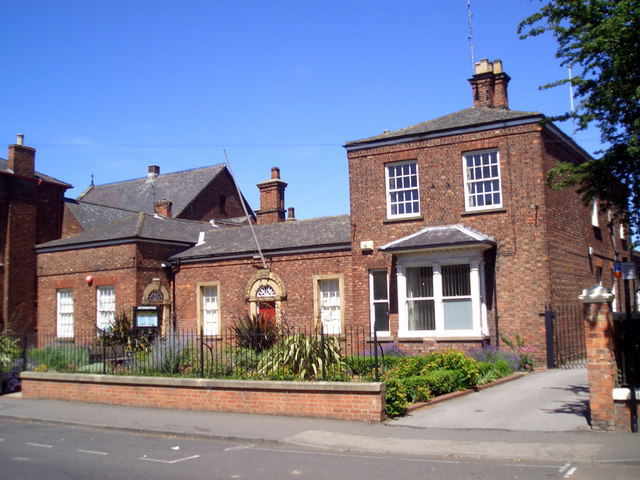
Barton-upon-Humber Police Station

The Former Police Station, Barton-upon-Humber is a Grade II Listed building in Barton-upon-Humber, North Lincolnshire, England. == History == The building...

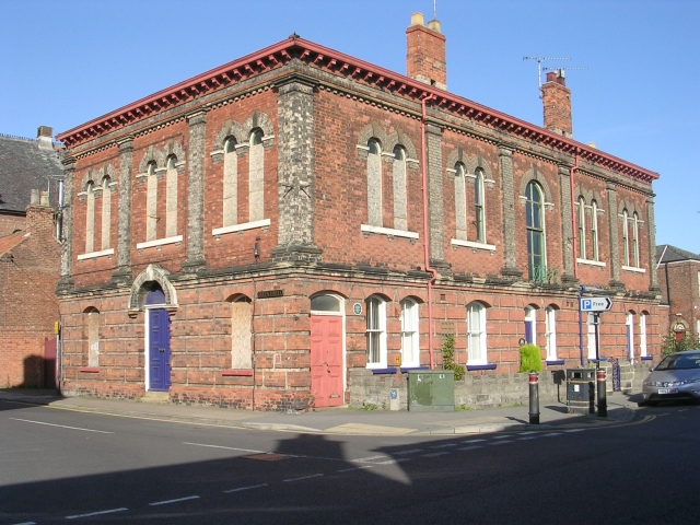
Oddfellows' Hall, Barton-upon-Humber

The former Oddfellows' Hall in Barton-upon-Humber is a Grade II Listed building constructed in 1864 by the Barton Lodge of the Odd Fellows Society. As...

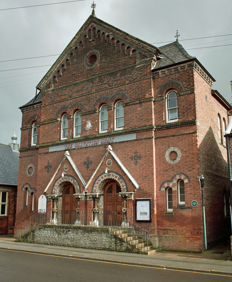
Salvation Army Citadel, Barton-upon-Humber

The Salvation Army Citadel is a Grade II Listed building in Barton-upon-Humber, North Lincolnshire, England. It was founded in 1867 by Joseph Wright as...

Wilderspin National School

The Wilderspin National School is a former national school and Grade II listed building in Barton-upon-Humber, North Lincolnshire, and a museum focussing...

Nearby Amenities

Located within 500m of 53.68466,-0.438811
Barton-upon-Humber
Place: town
Source: npe
Lat/Long: 53.6858065/-0.4395216
Mini Roundabout
Direction: clockwise
Lat/Long: 53.6862079/-0.4447456
Source: www.npemap.org.uk
Uk Postcode Centroid: DN18
Lat/Long: 53.6873603/-0.4435613
Mini Roundabout
Direction: clockwise
Lat/Long: 53.6837057/-0.4364172
Bus Stop
Baysgarth School
Alt Name: Green Lane
Bus: yes
Naptan AltCommonName: Green Lane
Naptan AltIndicator: adj
Naptan AltStreet: Barrow Road
Naptan AtcoCode: 227000010048
Naptan Bearing: E
Naptan CommonName: Baysgarth School
Naptan Indicator: opp
Naptan NaptanCode: scumgjg
Naptan Street: Barrow Road
Naptan Verified: no
Public Transport: platform
Source: naptan_import
Lat/Long: 53.6820367/-0.434432
Bus Stop
Baysgarth School
Bus: yes
Naptan AtcoCode: 227000010049
Naptan Bearing: W
Naptan CommonName: Baysgarth School
Naptan Indicator: o/s
Naptan Landmark: School
Naptan NaptanCode: scumpjg
Naptan Street: Barrow Road
Naptan Verified: no
Public Transport: platform
Source: naptan_import
Lat/Long: 53.6819221/-0.4339214
Bus Stop
Butts Road
Alt Name: Marsh Lane
Naptan AltCommonName: Marsh Lane
Naptan AltIndicator: adj
Naptan AltStreet: Butts Road
Naptan AtcoCode: 227000010050
Naptan Bearing: E
Naptan CommonName: Butts Road
Naptan Indicator: o/s 73
Naptan NaptanCode: scumtjg
Naptan Street: Butts Road
Naptan Verified: no
Source: naptan_import
Lat/Long: 53.6881493/-0.4371735
Bus Stop
Butts Road
Alt Name: Queens Avenue
Naptan AltCommonName: Queens Avenue
Naptan AltIndicator: adj
Naptan AltStreet: Butts Road
Naptan AtcoCode: 227000010051
Naptan Bearing: W
Naptan CommonName: Butts Road
Naptan Indicator: o/s 108
Naptan NaptanCode: scuajad
Naptan Street: Butts Road
Naptan Verified: no
Source: naptan_import
Lat/Long: 53.6880548/-0.4375102
Bus Stop
Holydyke
Bench: yes
Bus: yes
Naptan AtcoCode: 227000010055
Naptan Bearing: NE
Naptan CommonName: Holydyke
Naptan Indicator: adj
Naptan NaptanCode: scuawad
Naptan Street: Ferriby Road
Naptan Verified: no
Public Transport: platform
Shelter: yes
Source: naptan_import
Wheelchair: yes
Lat/Long: 53.6845159/-0.4453339
Bus Stop
Holydyke
Bus: yes
Naptan AtcoCode: 227000010056
Naptan Bearing: SW
Naptan CommonName: Holydyke
Naptan Indicator: o/s 17
Naptan NaptanCode: scudgad
Naptan Street: Ferriby Road
Naptan Verified: no
Public Transport: platform
Source: naptan_import
Lat/Long: 53.6844429/-0.4452457
Bus Stop
Fire Station
Alt Name: Library;Library;Police Station
Bench: yes
Bus: yes
Naptan AltCommonName: Library;Police Station
Naptan AltIndicator: adj;o/s
Naptan AltStreet: Hoydyke;Holydyke
Naptan AtcoCode: 227000010059
Naptan Bearing: E
Naptan CommonName: Fire Station
Naptan Indicator: opp
Naptan NaptanCode: scudpad
Naptan Street: Holydyke
Naptan Verified: no
Public Transport: platform
Shelter: yes
Source: naptan_import
Wheelchair: yes
Lat/Long: 53.6842851/-0.4431571
Bus Stop
Market Place
Alt Name: Somerfields
Bus: yes
Naptan AltCommonName: Somerfields
Naptan AltIndicator: adj
Naptan AltStreet: Market Lane
Naptan AtcoCode: 227000010061
Naptan Bearing: E
Naptan CommonName: Market Place
Naptan Indicator: adj
Naptan NaptanCode: scudwad
Naptan Street: Market Lane
Naptan Verified: no
Public Transport: platform
Shelter: yes
Source: naptan_import
Lat/Long: 53.6825505/-0.4379865
Bus Stop
Market Place
Alt Name: Somerfields
Bench: yes
Bus: yes
Naptan AltCommonName: Somerfields
Naptan AltIndicator: opp
Naptan AltStreet: Market Lane
Naptan AtcoCode: 227000010062
Naptan Bearing: W
Naptan CommonName: Market Place
Naptan Indicator: opp
Naptan NaptanCode: scugdad
Naptan Street: Market Lane
Naptan Verified: no
Public Transport: platform
Shelter: yes
Source: naptan_import
Wheelchair: yes
Lat/Long: 53.6827155/-0.4389192
Bus Stop
East Grove
Bus: yes
Naptan AtcoCode: 227000010063
Naptan Bearing: S
Naptan CommonName: East Grove
Naptan Indicator: adj
Naptan NaptanCode: scugjad
Naptan Street: Pasture Road
Naptan Verified: no
Public Transport: platform
Source: naptan_import
Lat/Long: 53.6856323/-0.4337383
Bus Stop
East Grove
Alt Name: Greenway
Bus: yes
Naptan AltCommonName: Greenway
Naptan AltIndicator: opp
Naptan AltStreet: Pasture Road
Naptan AtcoCode: 227000010064
Naptan Bearing: N
Naptan CommonName: East Grove
Naptan Indicator: opp
Naptan NaptanCode: scugmad
Naptan Street: Pasture Road
Naptan Verified: no
Public Transport: platform
Source: naptan_import
Lat/Long: 53.6865187/-0.4334631
Bus Stop
Bowmandale House
Bus: yes
Naptan AtcoCode: 227000010937
Naptan Bearing: S
Naptan CommonName: Bowmandale House
Naptan Indicator: o/s
Naptan NaptanCode: scumdgw
Naptan Street: Bowmandale
Naptan Verified: no
Public Transport: platform
Source: naptan_import
Lat/Long: 53.6836515/-0.442624
Bus Stop
Queen Street
Alt Name: High Street;High Street;Salvation Army
Bus: yes
Naptan AltCommonName: High Street;Salvation Army
Naptan AltIndicator: o/s 25;opp
Naptan AltStreet: High Street;High Street
Naptan AtcoCode: 227000010939
Naptan Bearing: W
Naptan CommonName: Queen Street
Naptan Indicator: opp
Naptan NaptanCode: scumpgw
Naptan Street: High Street
Naptan Verified: no
Public Transport: platform
Source: naptan_import
Lat/Long: 53.6848809/-0.4402172
Bus Stop
Queen Street
Alt Name: High Street
Bus: yes
Naptan AltCommonName: High Street
Naptan AltIndicator: o/s 16
Naptan AltStreet: High Street
Naptan AtcoCode: 227000010940
Naptan Bearing: E
Naptan CommonName: Queen Street
Naptan Indicator: adj
Naptan NaptanCode: scumtgw
Naptan Street: High Street
Naptan Verified: no
Public Transport: platform
Source: naptan_import
Lat/Long: 53.6849633/-0.4403353
Pub
Volunteer Arms
Addr City: Barton-upon-Humber
Addr Housenumber: 13
Addr Postcode: DN18 5DF
Addr Street: Whitecross Street
Fhrs Id: 214374
Source Addr: FHRS Open Data
Wikidata: Q26363514
Wikipedia: en:The Volunteer Arms, Barton-upon-Humber
Lat/Long: 53.6820996/-0.4377656
Crossing
Crossing: traffic_signals
Crossing Ref: toucan
Kerb: lowered
Source: survey
Tactile Paving: yes
Wheelchair: yes
Lat/Long: 53.6821792/-0.4369313
The Blue Bell (Closed)
Disused Amenity: pub
Lat/Long: 53.68237/-0.4371289
Pub
The George Hotel
Wikidata: Q26630307
Lat/Long: 53.683113/-0.4397265
Pub
The Red Lion
Addr City: Barton-upon-Humber
Addr Housenumber: 72-74
Addr Postcode: DN18 5PG
Addr Street: High Street
Fhrs Id: 213731
Source Addr: FHRS Open Data
Lat/Long: 53.6852957/-0.4422717
Pub
The Coach & Horses
Wikidata: Q26363703
Lat/Long: 53.6857659/-0.4434089
Pub
Lat/Long: 53.6878825/-0.4440505
Pub
The Mill
Lat/Long: 53.6823387/-0.4385627
Pub
The Wheat Sheaf
Wikidata: Q26363561
Lat/Long: 53.6830258/-0.4403469
Turning Circle
Lat/Long: 53.6825182/-0.4450321
Turning Circle
Lat/Long: 53.6835534/-0.4330913
Mini Roundabout
Direction: clockwise
Lat/Long: 53.6848296/-0.444219
Crossing
Crossing: zebra
Tactile Paving: yes
Lat/Long: 53.6829212/-0.4393072
Baysgarth House Museum
Addr City: Barton-upon-Humber
Addr Postcode: DN18 6AH
Addr Street: Caistor Road
Contact Facebook: https://www.facebook.com/Barton-Museum-at-Baysgarth-House-108000361427526
Museum: history
Tourism: museum
Website: https://www.visitnorthlincolnshire.com/item/baysgarth-house-museum/
Wikidata: Q4874791
Wikipedia: en:Baysgarth House Museum
Lat/Long: 53.6804762/-0.43874
Cafe
Partners Cafe
Cuisine: coffee_shop
Smoking: no
Lat/Long: 53.6852932/-0.443062
Cafe
Wilderspin National School
Cuisine: coffee_shop
Lat/Long: 53.6855115/-0.4392108
Bar
Victory Club
Addr City: Barton-upon-Humber
Addr Postcode: DN18 5PW
Addr Street: Hungate
Brewery: various
Contact Facebook: https://www.facebook.com/victoryclub17/
Fhrs Id: 214288
Opening Hours: Mo-Th, Su 12:00-23:00; Fr-Sa 12:00-00:00
Real Ale: yes
Source Addr: FHRS Open Data
Lat/Long: 53.685293/-0.4435152
SJD Computers Limited
Addr City: Barton-upon-Humber
Addr Housenumber: 31
Addr Postcode: DN18 5QN
Addr Street: Queens Avenue
Email: Info@tachograph.co.uk
Opening Hours: Mo-Fr 09:00-18:00
Operator: SJD Computers Limited
Phone: +44 1724 854424
Shop: Tachograph_Analysis_&_Vehicle_Telematics
Website: https://tachograph.co.uk/
Lat/Long: 53.6875707/-0.4392411
Restaurant
The Huntsman
Addr City: Barton-upon-Humber
Addr Housenumber: 6a
Addr Postcode: DN18 5PS
Addr Street: Holydyke
Fhrs Id: 767697
Opening Hours: Mo-Su 12:00-21:00
Phone: +44 1652660789
Source Addr: FHRS Open Data
Website: http://www.thehuntsmanbarton.co.uk/
Lat/Long: 53.6832228/-0.4402892
Toilets
Access: yes
Drinking Water: no
Fee: no
Female: yes
Male: yes
Operator: Council
Toilets Wheelchair: yes
Wheelchair: yes
Lat/Long: 53.6826611/-0.4388857
Bench
Lat/Long: 53.6840957/-0.4351676
Generator Method: photovoltaic
Generator Output Electricity: yes
Generator Source: solar
Generator Type: solar_photovoltaic_panel
Location: roof
Power: generator
Lat/Long: 53.6805118/-0.4378733
Generator Method: photovoltaic
Generator Output Electricity: yes
Generator Source: solar
Generator Type: solar_photovoltaic_panel
Location: roof
Power: generator
Lat/Long: 53.6888101/-0.4361701
Generator Method: photovoltaic
Generator Output Electricity: yes
Generator Source: solar
Generator Type: solar_photovoltaic_panel
Location: roof
Power: generator
Lat/Long: 53.6882097/-0.4370794
Generator Method: photovoltaic
Generator Output Electricity: yes
Generator Source: solar
Generator Type: solar_photovoltaic_panel
Location: roof
Power: generator
Lat/Long: 53.6845976/-0.4358187
Generator Method: photovoltaic
Generator Output Electricity: yes
Generator Source: solar
Generator Type: solar_photovoltaic_panel
Location: roof
Power: generator
Lat/Long: 53.6865387/-0.4323801
Generator Method: photovoltaic
Generator Output Electricity: yes
Generator Source: solar
Generator Type: solar_photovoltaic_panel
Location: roof
Power: generator
Lat/Long: 53.6842561/-0.4321575
Generator Method: photovoltaic
Generator Output Electricity: yes
Generator Source: solar
Generator Type: solar_photovoltaic_panel
Location: roof
Power: generator
Lat/Long: 53.6841147/-0.4319724
W.A. Clarke Footwear
Addr City: Barton-upon-Humber
Addr Housenumber: 106-108
Addr Postcode: DN18 5PU
Addr Street: High Street
Operator: W.A. Clarke
Payment Cash: yes
Payment Credit Cards: yes
Payment Debit Cards: yes
Payment Telephone Cards: yes
Shop: shoes
Lat/Long: 53.6863012/-0.4445407
Boyes
Brand: Boyes
Brand Wikidata: Q7958471
Brand Wikipedia: en:Boyes (retailer)
Shop: department_store
Lat/Long: 53.6857232/-0.4438539
Heron Foods
Addr City: Barton-upon-Humber
Addr Postcode: DN18 5PU
Addr Street: High Street
Brand: Heron Foods
Brand Wikidata: Q5743472
Brand Wikipedia: en:Heron Foods
Contact Website: https://heronfoods.com/store/barton-high-street/
Fhrs Id: 1197847
Old Name: Lidl
Shop: supermarket
Lat/Long: 53.6856405/-0.4439864
Crossing
Crossing: zebra
Crossing Island: no
Tactile Paving: yes
Lat/Long: 53.6841371/-0.4426221
Noexit: yes
Lat/Long: 53.6843767/-0.4400238
Generator Method: photovoltaic
Generator Output Electricity: yes
Generator Source: solar
Generator Type: solar_photovoltaic_panel
Location: roof
Power: generator
Lat/Long: 53.6873107/-0.4354271
Generator Method: photovoltaic
Generator Output Electricity: yes
Generator Source: solar
Generator Type: solar_photovoltaic_panel
Location: roof
Power: generator
Lat/Long: 53.6869993/-0.4348773
Generator Method: photovoltaic
Generator Output Electricity: yes
Generator Source: solar
Generator Type: solar_photovoltaic_panel
Location: roof
Power: generator
Lat/Long: 53.6882541/-0.437074
Generator Method: photovoltaic
Generator Output Electricity: yes
Generator Source: solar
Generator Type: solar_photovoltaic_panel
Location: roof
Power: generator
Lat/Long: 53.6882303/-0.4375622
Generator Method: photovoltaic
Generator Output Electricity: yes
Generator Source: solar
Generator Type: solar_photovoltaic_panel
Location: roof
Power: generator
Lat/Long: 53.6873218/-0.4376346
Generator Method: photovoltaic
Generator Output Electricity: yes
Generator Source: solar
Generator Type: solar_photovoltaic_panel
Location: roof
Power: generator
Lat/Long: 53.6884003/-0.4409954
Generator Method: photovoltaic
Generator Output Electricity: yes
Generator Source: solar
Generator Type: solar_photovoltaic_panel
Location: roof
Power: generator
Lat/Long: 53.6859144/-0.4451448
Generator Method: photovoltaic
Generator Output Electricity: yes
Generator Source: solar
Generator Type: solar_photovoltaic_panel
Location: roof
Power: generator
Lat/Long: 53.6850503/-0.4430392
Generator Method: photovoltaic
Generator Output Electricity: yes
Generator Source: solar
Generator Type: solar_photovoltaic_panel
Location: roof
Power: generator
Lat/Long: 53.685009/-0.4431653
Generator Method: photovoltaic
Generator Output Electricity: yes
Generator Source: solar
Generator Type: solar_photovoltaic_panel
Location: roof
Power: generator
Lat/Long: 53.6856103/-0.4359314
Generator Method: photovoltaic
Generator Output Electricity: yes
Generator Source: solar
Generator Type: solar_photovoltaic_panel
Location: roof
Power: generator
Lat/Long: 53.6856238/-0.435977
Generator Method: photovoltaic
Generator Output Electricity: yes
Generator Source: solar
Generator Type: solar_photovoltaic_panel
Location: roof
Power: generator
Lat/Long: 53.6850551/-0.4349256
Generator Method: photovoltaic
Generator Output Electricity: yes
Generator Source: solar
Generator Type: solar_photovoltaic_panel
Location: roof
Power: generator
Lat/Long: 53.6847469/-0.4357812
Generator Method: photovoltaic
Generator Output Electricity: yes
Generator Source: solar
Generator Type: solar_photovoltaic_panel
Location: roof
Power: generator
Lat/Long: 53.6848375/-0.4357262
Generator Method: photovoltaic
Generator Output Electricity: yes
Generator Source: solar
Generator Type: solar_photovoltaic_panel
Location: roof
Power: generator
Lat/Long: 53.6849368/-0.4356672
Generator Method: photovoltaic
Generator Output Electricity: yes
Generator Source: solar
Generator Type: solar_photovoltaic_panel
Location: roof
Power: generator
Lat/Long: 53.6849129/-0.4355975
Generator Method: photovoltaic
Generator Output Electricity: yes
Generator Source: solar
Generator Type: solar_photovoltaic_panel
Location: roof
Power: generator
Lat/Long: 53.6848256/-0.4356511
Generator Method: photovoltaic
Generator Output Electricity: yes
Generator Source: solar
Generator Type: solar_photovoltaic_panel
Location: roof
Power: generator
Lat/Long: 53.684731/-0.4357074
Generator Method: photovoltaic
Generator Output Electricity: yes
Generator Source: solar
Generator Type: solar_photovoltaic_panel
Location: roof
Power: generator
Lat/Long: 53.684654/-0.4358456
Generator Method: photovoltaic
Generator Output Electricity: yes
Generator Source: solar
Generator Type: solar_photovoltaic_panel
Location: roof
Power: generator
Lat/Long: 53.6847422/-0.4320301
Generator Method: photovoltaic
Generator Output Electricity: yes
Generator Source: solar
Generator Type: solar_photovoltaic_panel
Location: roof
Power: generator
Lat/Long: 53.6847382/-0.432061
Generator Method: photovoltaic
Generator Output Electricity: yes
Generator Source: solar
Generator Type: solar_photovoltaic_panel
Location: roof
Power: generator
Lat/Long: 53.6816969/-0.4344501
Generator Method: photovoltaic
Generator Output Electricity: yes
Generator Source: solar
Generator Type: solar_photovoltaic_panel
Location: roof
Power: generator
Lat/Long: 53.6810154/-0.436779
Generator Method: photovoltaic
Generator Output Electricity: yes
Generator Source: solar
Generator Type: solar_photovoltaic_panel
Location: roof
Power: generator
Lat/Long: 53.681025/-0.4368272
Generator Method: photovoltaic
Generator Output Electricity: yes
Generator Source: solar
Generator Type: solar_photovoltaic_panel
Location: roof
Power: generator
Lat/Long: 53.6826136/-0.4424572
Generator Method: photovoltaic
Generator Output Electricity: yes
Generator Source: solar
Generator Type: solar_photovoltaic_panel
Location: roof
Power: generator
Lat/Long: 53.6829344/-0.4416177
Generator Method: photovoltaic
Generator Output Electricity: yes
Generator Source: solar
Generator Type: solar_photovoltaic_panel
Location: roof
Power: generator
Lat/Long: 53.6839749/-0.4442409
Generator Method: photovoltaic
Generator Output Electricity: yes
Generator Source: solar
Generator Type: solar_photovoltaic_panel
Location: roof
Power: generator
Lat/Long: 53.6835905/-0.4454532
Generator Method: photovoltaic
Generator Output Electricity: yes
Generator Source: solar
Generator Type: solar_photovoltaic_panel
Location: roof
Power: generator
Lat/Long: 53.6835826/-0.4452333
Generator Method: photovoltaic
Generator Output Electricity: yes
Generator Source: solar
Generator Type: solar_photovoltaic_panel
Location: roof
Power: generator
Lat/Long: 53.6835428/-0.4450777
Generator Method: photovoltaic
Generator Output Electricity: yes
Generator Source: solar
Generator Type: solar_photovoltaic_panel
Location: roof
Power: generator
Lat/Long: 53.6837954/-0.4451609
Generator Method: photovoltaic
Generator Output Electricity: yes
Generator Source: solar
Generator Type: solar_photovoltaic_panel
Location: roof
Power: generator
Lat/Long: 53.6838018/-0.4452467
Generator Method: photovoltaic
Generator Output Electricity: yes
Generator Source: solar
Generator Type: solar_photovoltaic_panel
Location: roof
Power: generator
Lat/Long: 53.6830329/-0.4438868
Generator Method: photovoltaic
Generator Output Electricity: yes
Generator Source: solar
Generator Type: solar_photovoltaic_panel
Location: roof
Power: generator
Lat/Long: 53.6825707/-0.4444662
Generator Method: photovoltaic
Generator Output Electricity: yes
Generator Source: solar
Generator Type: solar_photovoltaic_panel
Location: roof
Power: generator
Lat/Long: 53.6825611/-0.4446378
Generator Method: photovoltaic
Generator Output Electricity: yes
Generator Source: solar
Generator Type: solar_photovoltaic_panel
Location: roof
Power: generator
Lat/Long: 53.6825865/-0.4448095
Generator Method: photovoltaic
Generator Output Electricity: yes
Generator Source: solar
Generator Type: solar_photovoltaic_panel
Location: roof
Power: generator
Lat/Long: 53.6813935/-0.4439271
Generator Method: photovoltaic
Generator Output Electricity: yes
Generator Source: solar
Generator Type: solar_photovoltaic_panel
Location: roof
Power: generator
Lat/Long: 53.6813983/-0.4439834
Generator Method: photovoltaic
Generator Output Electricity: yes
Generator Source: solar
Generator Type: solar_photovoltaic_panel
Location: roof
Power: generator
Lat/Long: 53.6816016/-0.4442489
Generator Method: photovoltaic
Generator Output Electricity: yes
Generator Source: solar
Generator Type: solar_photovoltaic_panel
Location: roof
Power: generator
Lat/Long: 53.6816239/-0.4443616
Generator Method: photovoltaic
Generator Output Electricity: yes
Generator Source: solar
Generator Type: solar_photovoltaic_panel
Location: roof
Power: generator
Lat/Long: 53.6809892/-0.4431492
Generator Method: photovoltaic
Generator Output Electricity: yes
Generator Source: solar
Generator Type: solar_photovoltaic_panel
Location: roof
Power: generator
Lat/Long: 53.6822974/-0.439547
Generator Method: photovoltaic
Generator Output Electricity: yes
Generator Source: solar
Generator Type: solar_photovoltaic_panel
Location: roof
Power: generator
Lat/Long: 53.6823085/-0.4396275
Generator Method: photovoltaic
Generator Output Electricity: yes
Generator Source: solar
Generator Type: solar_photovoltaic_panel
Location: roof
Power: generator
Lat/Long: 53.6812168/-0.4416975
Generator Method: photovoltaic
Generator Output Electricity: yes
Generator Source: solar
Generator Type: solar_photovoltaic_panel
Location: roof
Power: generator
Lat/Long: 53.6806445/-0.4415225
Post Office
Barton on Humber Post Office
Addr City: Barton-upon-Humber
Addr Housenumber: 32
Addr Postcode: DN18 5HA
Addr Street: Burgate
Brand: Post Office
Brand Wikidata: Q1783168
Check Date: 2022-05-27
Check Date Opening Hours: 2022-05-27
Contact Website: https://www.postoffice.co.uk/branch-finder/3783111/barton-on-humber
Opening Hours: Mo-Fr 08:45-17:30; Sa 08:45-13:00
Ref Pol Id: 14107
Lat/Long: 53.68469/-0.43834
Recycling
Description: only for small quantities like litter
Recycling Cans: yes
Recycling Glass Bottles: yes
Recycling Paper: yes
Recycling Plastic Bottles: yes
Lat/Long: 53.6827203/-0.4389525
Waste Basket
Ashtray: yes
Lat/Long: 53.6827201/-0.4389591
Charging Station
Cottage Lane Carpark
Network: Swaco E.Connect
Opening Hours: Mo-Su 09:00-17:00
Socket Type2: 2
Socket Type2 Output: 22kW
Lat/Long: 53.684596/-0.4403289
Charging Station
The George Inn
Operator: Tesla Type 2
Socket Type2 Cable: 1
Socket Type2 Cable Output: 11kW
Lat/Long: 53.6832045/-0.4399332
The data included in this document is from www.openstreetmap.org. The data is made available under ODbL.

Have you been to Barton-Upon-Humber?

Leave your review of Barton-Upon-Humber below (or comments, questions and feedback).