Eilean a' Chail

Island in Ross-shire

Scotland

Eilean a' Chail

West coast of Great Bernera This is the west side of a spit of land extending south of Tobson. The ground is rocky with a thin covering of grass.

In the distance, on the left is the tip of the island of Pabaigh Mor .. and on the right Geodha Mor (west of Tobson).
West coast of Great Bernera Credit: Rob Burke

Eilean a' Chail is a small island located off the coast of Ross-shire, Scotland. Also known as The Island of the Old Woman, it sits in the Inner Sound, which separates the mainland from the Isle of Skye. The island covers an area of approximately 10 acres and is uninhabited.

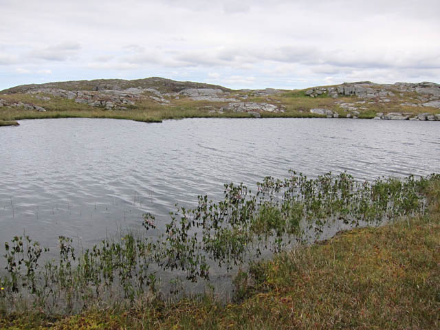
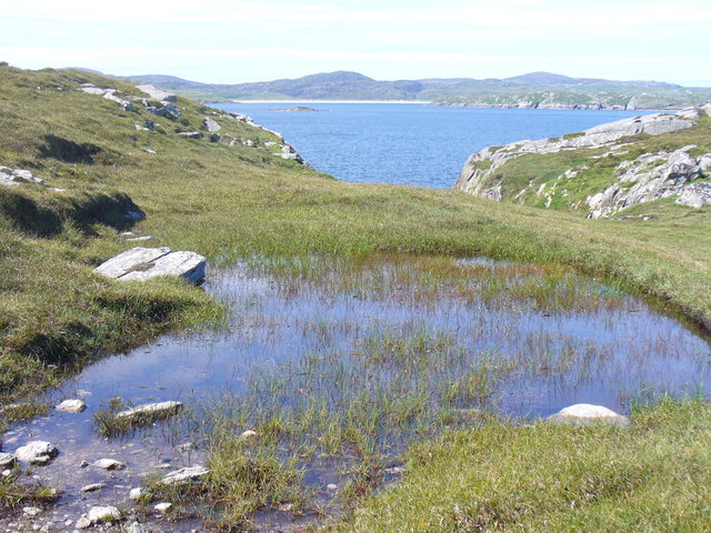
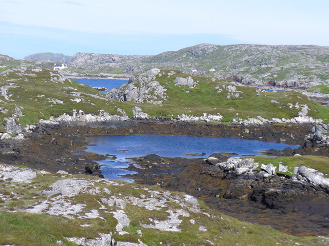
Eilean a' Chail is characterized by its rugged and rocky terrain, with steep cliffs and a rugged shoreline. The island is surrounded by the clear waters of the Inner Sound, making it a popular spot for boating and fishing enthusiasts. The island is also home to a variety of seabirds, including puffins, guillemots, and razorbills, making it a haven for birdwatchers.

The island is accessible by boat, and there are regular ferry services from nearby ports, such as Kyle of Lochalsh. Visitors to Eilean a' Chail can explore the island's natural beauty and enjoy the peaceful and tranquil atmosphere. The cliffs offer stunning panoramic views of the surrounding area, including the nearby Skye Bridge and the Cuillin Mountains.

Eilean a' Chail is a place of natural beauty and solitude, offering a unique escape from the hustle and bustle of modern life. It is a must-visit destination for nature lovers, photographers, and those seeking a peaceful retreat in the heart of the Scottish Highlands.

If you have any feedback on the listing, please let us know in the comments section below.

Eilean a' Chail Images

Images are sourced within 2km of 58.238699/-6.8682241 or Grid Reference NB1438. Thanks to Geograph Open Source API. All images are credited.

West coast of Great Bernera This is the west side of a spit of land extending south of Tobson. The ground is rocky with a thin covering of grass.

In the distance, on the left is the tip of the island of Pabaigh Mor .. and on the right Geodha Mor (west of Tobson).
West coast of Great Bernera
This is the west side of a spit of land extending south of Tobson. The ground is rocky with a thin covering of grass. In the distance, on the left is the tip of the island of Pabaigh Mor .. and on the right Geodha Mor (west of Tobson).
Camas Sanndaig Looking across the bay. In the distance is the low island of Pabaigh Mor with the headland of Bhaltos beyond.

A bundle of fencing wire is abandoned in the rocky gully above the sea.
Camas Sanndaig
Looking across the bay. In the distance is the low island of Pabaigh Mor with the headland of Bhaltos beyond. A bundle of fencing wire is abandoned in the rocky gully above the sea.
Beach north of Bhalasaigh
Sea loch west of Loch Veiravat Although it isn't obvious from here, this is the start of a long channel that leads out to the sea.
Sea loch west of Loch Veiravat
Although it isn't obvious from here, this is the start of a long channel that leads out to the sea.
Moorland and loch on Great Bernera The loch is unnamed on the map, but the Allt Loch an Fheoir flows into it, so this must be Loch an Fheoir.

The houses in the distance are on the road south of Bhalasaigh.
Moorland and loch on Great Bernera
The loch is unnamed on the map, but the Allt Loch an Fheoir flows into it, so this must be Loch an Fheoir. The houses in the distance are on the road south of Bhalasaigh.
Waymarked coastal walk There are clear waymarks on the route from the community centre to Bosta on Great Bernera. Return by the same route or on the road.
Waymarked coastal walk
There are clear waymarks on the route from the community centre to Bosta on Great Bernera. Return by the same route or on the road.
Small loch on Great Bernera The waymarked path to Bosta passes right by this loch.
Small loch on Great Bernera
The waymarked path to Bosta passes right by this loch.
Bridge at Bhalasaigh Looking back to the road end on the main island of Great Bernera.
Bridge at Bhalasaigh
Looking back to the road end on the main island of Great Bernera.
West coast of Great Bernera A complicated coastline with many interesting features.
West coast of Great Bernera
A complicated coastline with many interesting features.
Tob Bhalasaigh Tidal lagoon with a mix of rare seaweeds on Great Bernera / Bearnaraigh.
<span class="nowrap"><a title="http://www.uigandbernera.com/" rel="nofollow ugc noopener" href="http://www.uigandbernera.com/">Link</a><img style="margin-left:2px;" alt="External link" title="External link - shift click to open in new window" src="https://s1.geograph.org.uk/img/external.png" width="10" height="10"/></span>
Tob Bhalasaigh
Tidal lagoon with a mix of rare seaweeds on Great Bernera / Bearnaraigh. LinkExternal link
Valasay Bridge Carrying the single track road across an outlet of the tidal lagoon, Tob Bhalasaigh on Great Bernera / Bearnaraigh.
<span class="nowrap"><a title="http://www.uigandbernera.com/" rel="nofollow ugc noopener" href="http://www.uigandbernera.com/">Link</a><img style="margin-left:2px;" alt="External link" title="External link - shift click to open in new window" src="https://s1.geograph.org.uk/img/external.png" width="10" height="10"/></span>
Valasay Bridge
Carrying the single track road across an outlet of the tidal lagoon, Tob Bhalasaigh on Great Bernera / Bearnaraigh. LinkExternal link
Shoreline at Tob Bhalasaigh Rocks and heather at the edge of the tidal lagoon in Valasay.
<span class="nowrap"><a title="http://www.uigandbernera.com/" rel="nofollow ugc noopener" href="http://www.uigandbernera.com/">Link</a><img style="margin-left:2px;" alt="External link" title="External link - shift click to open in new window" src="https://s1.geograph.org.uk/img/external.png" width="10" height="10"/></span>
Shoreline at Tob Bhalasaigh
Rocks and heather at the edge of the tidal lagoon in Valasay. LinkExternal link
Valasay Footbridge The bridge across the tidal Tob Bhalasaigh was built in 1898.
<span class="nowrap"><a title="http://www.uigandbernera.com/" rel="nofollow ugc noopener" href="http://www.uigandbernera.com/">Link</a><img style="margin-left:2px;" alt="External link" title="External link - shift click to open in new window" src="https://s1.geograph.org.uk/img/external.png" width="10" height="10"/></span>
Valasay Footbridge
The bridge across the tidal Tob Bhalasaigh was built in 1898. LinkExternal link
Tidal Lagoon, Valasay Tob Bhalasaigh, on the island of Great Bernera / Bearnaraigh.
<span class="nowrap"><a title="http://www.uigandbernera.com/" rel="nofollow ugc noopener" href="http://www.uigandbernera.com/">Link</a><img style="margin-left:2px;" alt="External link" title="External link - shift click to open in new window" src="https://s1.geograph.org.uk/img/external.png" width="10" height="10"/></span>
Tidal Lagoon, Valasay
Tob Bhalasaigh, on the island of Great Bernera / Bearnaraigh. LinkExternal link
Tob Bhalasaigh from the Footbridge View northwards, along the narrow tidal lagoon, to Tobson 2 kilometres away in the distance.
Tob Bhalasaigh from the Footbridge
View northwards, along the narrow tidal lagoon, to Tobson 2 kilometres away in the distance.
Poll Ula On the indistinct coastal path along the west coast of great Bernera / Bearnaraigh. Well placed wooden marker posts are easy to follow.
<span class="nowrap"><a title="http://www.uigandbernera.com/" rel="nofollow ugc noopener" href="http://www.uigandbernera.com/">Link</a><img style="margin-left:2px;" alt="External link" title="External link - shift click to open in new window" src="https://s1.geograph.org.uk/img/external.png" width="10" height="10"/></span>
Poll Ula
On the indistinct coastal path along the west coast of great Bernera / Bearnaraigh. Well placed wooden marker posts are easy to follow. LinkExternal link
Above Geodha nan Uan On the Bernera coastal path with view across the sound to Traigh na Beirigh at Valtos.
<span class="nowrap"><a title="http://www.uigandbernera.com/" rel="nofollow ugc noopener" href="http://www.uigandbernera.com/">Link</a><img style="margin-left:2px;" alt="External link" title="External link - shift click to open in new window" src="https://s1.geograph.org.uk/img/external.png" width="10" height="10"/></span>
Above Geodha nan Uan
On the Bernera coastal path with view across the sound to Traigh na Beirigh at Valtos. LinkExternal link
Tob Lathach Small tidal lagoon on the west coast of Great Bernera / Bearnaraigh.
<span class="nowrap"><a title="http://www.uigandbernera.com/" rel="nofollow ugc noopener" href="http://www.uigandbernera.com/">Link</a><img style="margin-left:2px;" alt="External link" title="External link - shift click to open in new window" src="https://s1.geograph.org.uk/img/external.png" width="10" height="10"/></span>
Tob Lathach
Small tidal lagoon on the west coast of Great Bernera / Bearnaraigh. LinkExternal link
Show me another place!

Eilean a' Chail is located at Grid Ref: NB1438 (Lat: 58.238699, Lng: -6.8682241)

Unitary Authority: Na h-Eileanan an Iar

Police Authority: Highlands and Islands

What 3 Words

///deeply.pave.amending. Near Carloway, Na h-Eileanan Siar

Related Wikis

Bernera Riot

The Bernera Riot occurred in 1874, on the island of Great Bernera, in Scotland in response to the Highland Clearances. The use of the term 'Bernera Riot...

Great Bernera

Great Bernera (; Scottish Gaelic: Beàrnaraigh Mòr), often known just as Bernera (Scottish Gaelic: Beàrnaraigh), is an island and community in the Outer...

Breaclete

Breacleit (or Roulanish; Scottish Gaelic: Breacleit; Old Norse: Breiðiklettr) is the central village on Great Bernera in the Outer Hebrides, Scotland....

Dun Bharabhat, Great Bernera

Dun Bharabhat (or Dun Baravat) is an Iron Age galleried dun or "semi-broch" situated on the island of Great Bernera near Lewis in Scotland (grid reference...

Nearby Amenities

Located within 500m of 58.238699,-6.8682241
Passing Place
Lat/Long: 58.240021/-6.8733152
Passing Place
Lat/Long: 58.2381263/-6.8609663
Passing Place
Lat/Long: 58.2425452/-6.8671837
Passing Place
Lat/Long: 58.242085/-6.8643244
Passing Place
Lat/Long: 58.2388294/-6.8629512
Passing Place
Lat/Long: 58.2382731/-6.8620338
Turning Circle
Lat/Long: 58.2408917/-6.8725834
Power: pole
Lat/Long: 58.2425737/-6.8709253
Power: pole
Lat/Long: 58.2424335/-6.8699592
Power: pole
Lat/Long: 58.2423242/-6.8690948
Power: pole
Lat/Long: 58.2421638/-6.867964
Power: pole
Lat/Long: 58.2419537/-6.8666881
Power: pole
Lat/Long: 58.2413811/-6.865963
Power: pole
Lat/Long: 58.24068/-6.8656595
Power: pole
Lat/Long: 58.2404163/-6.8651359
Power: pole
Lat/Long: 58.2400302/-6.8642737
Power: pole
Lat/Long: 58.2394718/-6.8635085
Power: pole
Lat/Long: 58.2390619/-6.862863
Power: pole
Lat/Long: 58.2386413/-6.8621227
Power: pole
Lat/Long: 58.2382505/-6.8615945
Power: pole
Lat/Long: 58.2377396/-6.8608903
Power: pole
Lat/Long: 58.2417385/-6.8737251
Power: pole
Lat/Long: 58.2413287/-6.8734994
Power: pole
Lat/Long: 58.2408772/-6.8731744
Power: pole
Lat/Long: 58.2404484/-6.8732737
Power: pole
Lat/Long: 58.2398965/-6.873183
Power: pole
Lat/Long: 58.2394641/-6.8732196
Power: pole
Lat/Long: 58.2389651/-6.8728065
Power: pole
Lat/Long: 58.242234/-6.8661187
Power: pole
Lat/Long: 58.2428352/-6.866859
Power: pole
Lat/Long: 58.2431446/-6.8672539
Power: pole
Lat/Long: 58.2431292/-6.8681847
Power: pole
Lat/Long: 58.2431183/-6.869105
Power: pole
Lat/Long: 58.2430995/-6.8698389
Generator Method: photovoltaic
Generator Output Electricity: small_installation
Generator Source: solar
Generator Type: solar_photovoltaic_panel
Power: generator
Lat/Long: 58.2399317/-6.8646669
Barrier: cattle_grid
Lat/Long: 58.242499/-6.8671949
Passing Place
Lat/Long: 58.2424042/-6.8653561
Barrier: cattle_grid
Lat/Long: 58.2424404/-6.8664117
Passing Place
Lat/Long: 58.2430038/-6.8704274
Barrier: cattle_grid
Lat/Long: 58.2427758/-6.8686009
Generator Method: photovoltaic
Generator Output Electricity: small_installation
Generator Source: solar
Generator Type: solar_photovoltaic_panel
Power: generator
Lat/Long: 58.2387265/-6.8721918
Tob Mor Glas
Natural: bay
Lat/Long: 58.2359514/-6.8627048
Rubha Beag Glas
Natural: cape
Lat/Long: 58.2357791/-6.8657357
Rubha Mor Glas
Natural: cape
Lat/Long: 58.2361857/-6.8649847
Tob Buaile nan Gobhar
Natural: bay
Lat/Long: 58.2374932/-6.8620771
Passing Place
Lat/Long: 58.2399208/-6.863548
Passing Place
Lat/Long: 58.2412724/-6.8642375
Great Bernera Walk
Hiking: yes
Information: guidepost
Tourism: information
Lat/Long: 58.2347446/-6.8712024
Great Bernera Walk
Hiking: yes
Information: guidepost
Tourism: information
Lat/Long: 58.2362211/-6.8718999
Great Bernera Walk
Hiking: yes
Information: guidepost
Tourism: information
Lat/Long: 58.2381731/-6.8743635
Great Bernera Walk
Hiking: yes
Information: guidepost
Tourism: information
Lat/Long: 58.2353847/-6.8712604
Great Bernera Walk
Hiking: yes
Information: guidepost
Tourism: information
Lat/Long: 58.2375798/-6.873574
Great Bernera Walk
Hiking: yes
Information: guidepost
Tourism: information
Lat/Long: 58.2369888/-6.8727561
The data included in this document is from www.openstreetmap.org. The data is made available under ODbL.

Have you been to Eilean a' Chail?

Leave your review of Eilean a' Chail below (or comments, questions and feedback).