Sgeir Lag Isgamor

Island in Ross-shire

Scotland

Sgeir Lag Isgamor

The cemetery at Bostadh Perhaps not a surprising number of burials for such a remote location, as it is a very desirable place to be laid to rest.
The cemetery at Bostadh Credit: John Lucas

Sgeir Lag Isgamor is a small island located off the coast of Ross-shire, Scotland. It is situated in the Inner Hebrides, specifically in the Sound of Islay. The island is quite secluded, with no permanent human population and limited accessibility.

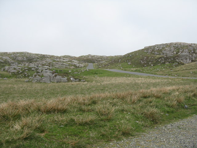
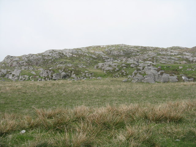
Sgeir Lag Isgamor is known for its rugged and rocky terrain, with steep cliffs and rocky outcrops dotting the landscape. The island is relatively small, measuring only a few acres in size. It is primarily composed of granite and has very little vegetation, making it appear barren and desolate.

Despite its lack of vegetation, Sgeir Lag Isgamor is a haven for various bird species. The island serves as an important breeding ground and roosting site for seabirds such as puffins, guillemots, and razorbills. These birds are attracted to the island's rocky cliffs, which provide nesting sites and protection from predators.

Due to its remote location and limited accessibility, Sgeir Lag Isgamor is mainly visited by birdwatchers and wildlife enthusiasts. The island offers a unique opportunity to observe and study seabirds in their natural habitat. It is important, however, to respect the fragile ecosystem and not disturb the nesting sites or wildlife.

Overall, Sgeir Lag Isgamor is a picturesque and untouched island, offering a glimpse into the diverse birdlife of the Inner Hebrides.

If you have any feedback on the listing, please let us know in the comments section below.

Sgeir Lag Isgamor Images

Images are sourced within 2km of 58.239305/-6.8709684 or Grid Reference NB1438. Thanks to Geograph Open Source API. All images are credited.

The cemetery at Bostadh Perhaps not a surprising number of burials for such a remote location, as it is a very desirable place to be laid to rest.
The cemetery at Bostadh
Perhaps not a surprising number of burials for such a remote location, as it is a very desirable place to be laid to rest.
The road to Bostadh With Siaram Bostadh in mid view on the left side.
The road to Bostadh
With Siaram Bostadh in mid view on the left side.
Bostadh Iron Age House The reconstructed house, viewed looking south.
Bostadh Iron Age House
The reconstructed house, viewed looking south.
Information about Bostadh Iron Age Village The Gaelic version.
Information about Bostadh Iron Age Village
The Gaelic version.
Information about Bostadh Iron Age Village The English version.
Information about Bostadh Iron Age Village
The English version.
Public convenience at Bostadh Near the end of the road at the cemetery and Iron Age Village.
Public convenience at Bostadh
Near the end of the road at the cemetery and Iron Age Village.
Iron Age Village at Bostadh A reconstructed house and, farther up the valley, traces of other houses.
Iron Age Village at Bostadh
A reconstructed house and, farther up the valley, traces of other houses.
Garden Tiger Moth larva A larva of Arctia caja on the path close to the Iron Age house at Bostadh. Thin plant growth on sand, with clear signs of rabbit grazing.
Garden Tiger Moth larva
A larva of Arctia caja on the path close to the Iron Age house at Bostadh. Thin plant growth on sand, with clear signs of rabbit grazing.
Iron Age House at Bostadh The inland end. Beyond is the path down from the car park.
Iron Age House at Bostadh
The inland end. Beyond is the path down from the car park.
Entrance to the Iron Age House A gap in the surrounding wall leads to the top of steps leading down to an underground entrance.
Entrance to the Iron Age House
A gap in the surrounding wall leads to the top of steps leading down to an underground entrance.
Iron Age House Underground doorway at the foot of the entrance steps. It is possible to go inside when the site is open.
Iron Age House
Underground doorway at the foot of the entrance steps. It is possible to go inside when the site is open.
Steps at the Iron Age House Leading up from the underground entrance.
Steps at the Iron Age House
Leading up from the underground entrance.
The road from Bostadh Near the cul-de-sac by the cemetery and Iron Age Village, at the northern end of Great Bernera/Beàrnaraigh.
The road from Bostadh
Near the cul-de-sac by the cemetery and Iron Age Village, at the northern end of Great Bernera/Beàrnaraigh.
Cnoc Ruinagaidh A rocky out crop near the roadend at Bostadh.
Cnoc Ruinagaidh
A rocky out crop near the roadend at Bostadh.
Replica Iron Age house at Bostadh Replica house built in 1999. <span class="nowrap"><a title="https://canmore.org.uk/site/268694/lewis-great-bernera-bosta" rel="nofollow ugc noopener" href="https://canmore.org.uk/site/268694/lewis-great-bernera-bosta">Link</a><img style="margin-left:2px;" alt="External link" title="External link - shift click to open in new window" src="https://s1.geograph.org.uk/img/external.png" width="10" height="10"/></span>
Replica Iron Age house at Bostadh
Replica house built in 1999. LinkExternal link
West coast of Great Bernera This is the west side of a spit of land extending south of Tobson. The ground is rocky with a thin covering of grass.

In the distance, on the left is the tip of the island of Pabaigh Mor .. and on the right Geodha Mor (west of Tobson).
West coast of Great Bernera
This is the west side of a spit of land extending south of Tobson. The ground is rocky with a thin covering of grass. In the distance, on the left is the tip of the island of Pabaigh Mor .. and on the right Geodha Mor (west of Tobson).
Camas Sanndaig Looking across the bay. In the distance is the low island of Pabaigh Mor with the headland of Bhaltos beyond.

A bundle of fencing wire is abandoned in the rocky gully above the sea.
Camas Sanndaig
Looking across the bay. In the distance is the low island of Pabaigh Mor with the headland of Bhaltos beyond. A bundle of fencing wire is abandoned in the rocky gully above the sea.
Beach north of Bhalasaigh
Show me another place!

Sgeir Lag Isgamor is located at Grid Ref: NB1438 (Lat: 58.239305, Lng: -6.8709684)

Unitary Authority: Na h-Eileanan an Iar

Police Authority: Highlands and Islands

What 3 Words

///overlook.spurned.hammocks. Near Carloway, Na h-Eileanan Siar

Related Wikis

Bernera Riot

The Bernera Riot occurred in 1874, on the island of Great Bernera, in Scotland in response to the Highland Clearances. The use of the term 'Bernera Riot...

Great Bernera

Great Bernera (; Scottish Gaelic: Beàrnaraigh Mòr), often known just as Bernera (Scottish Gaelic: Beàrnaraigh), is an island and community in the Outer...

Breaclete

Breacleit (or Roulanish; Scottish Gaelic: Breacleit; Old Norse: Breiðiklettr) is the central village on Great Bernera in the Outer Hebrides, Scotland....

Little Bernera

Little Bernera (Scottish Gaelic: Beàrnaraigh Beag) is a small island situated off the west coast of the Isle of Lewis in the Outer Hebrides.Little Bernera...

Related Videos

Outer Hebrides, Bostadh Beach

Bostadh Beach, Isle of Lewis, June 19th 2021.

The Isle of Great Bernera

Great Bernera is a small island off the coast of a bigger island, the isle of Lewis. Recently, I've been staying on the isle of Lewis ...

Great Bernera, Iron Age House

Great Bernera, Iron Age House, Bosta Beach. Outer Hebrides, Scotland.

Island Of Great Bernera On History Visit To The Outer Hebrides Of Scotland

Tour Scotland short travel video clip, with Scottish music, of the Island Of Great Bernera on ancestry, genealogy, history visit to the ...

Nearby Amenities

Located within 500m of 58.239305,-6.8709684
Passing Place
Lat/Long: 58.240021/-6.8733152
Passing Place
Lat/Long: 58.2425452/-6.8671837
Passing Place
Lat/Long: 58.2420525/-6.8776175
Passing Place
Lat/Long: 58.242085/-6.8643244
Passing Place
Lat/Long: 58.2388294/-6.8629512
Tòpsann
Alt Name Gd: Tòbsun;Tobsunn
Name En: Tobson
Name Gd: Tòpsann
Place: village
Lat/Long: 58.2428063/-6.8736748
Turning Circle
Lat/Long: 58.2408917/-6.8725834
Power: pole
Lat/Long: 58.2424157/-6.8764105
Power: pole
Lat/Long: 58.2426602/-6.8761069
Power: pole
Lat/Long: 58.2429565/-6.8754531
Power: pole
Lat/Long: 58.2432793/-6.8748176
Power: pole
Lat/Long: 58.2433221/-6.8740727
Power: pole
Lat/Long: 58.2431095/-6.8733077
Power: pole
Lat/Long: 58.2428707/-6.8721926
Power: pole
Lat/Long: 58.2425737/-6.8709253
Power: pole
Lat/Long: 58.2424335/-6.8699592
Power: pole
Lat/Long: 58.2423242/-6.8690948
Power: pole
Lat/Long: 58.2421638/-6.867964
Power: pole
Lat/Long: 58.2419537/-6.8666881
Power: pole
Lat/Long: 58.2413811/-6.865963
Power: pole
Lat/Long: 58.24068/-6.8656595
Power: pole
Lat/Long: 58.2404163/-6.8651359
Power: pole
Lat/Long: 58.2400302/-6.8642737
Power: pole
Lat/Long: 58.2394718/-6.8635085
Power: pole
Lat/Long: 58.2390619/-6.862863
Power: pole
Lat/Long: 58.2436152/-6.8730804
Power: pole
Lat/Long: 58.2427989/-6.8749275
Power: pole
Lat/Long: 58.2425452/-6.874154
Power: pole
Lat/Long: 58.242171/-6.873987
Power: pole
Lat/Long: 58.2417385/-6.8737251
Power: pole
Lat/Long: 58.2413287/-6.8734994
Power: pole
Lat/Long: 58.2408772/-6.8731744
Power: pole
Lat/Long: 58.2404484/-6.8732737
Power: pole
Lat/Long: 58.2398965/-6.873183
Power: pole
Lat/Long: 58.2394641/-6.8732196
Power: pole
Lat/Long: 58.2389651/-6.8728065
Power: pole
Lat/Long: 58.242234/-6.8661187
Power: pole
Lat/Long: 58.2428352/-6.866859
Power: pole
Lat/Long: 58.2431446/-6.8672539
Power: pole
Lat/Long: 58.2431292/-6.8681847
Power: pole
Lat/Long: 58.2431183/-6.869105
Power: pole
Lat/Long: 58.2430995/-6.8698389
Generator Method: photovoltaic
Generator Output Electricity: small_installation
Generator Source: solar
Generator Type: solar_photovoltaic_panel
Power: generator
Lat/Long: 58.2399317/-6.8646669
Barrier: cattle_grid
Lat/Long: 58.242499/-6.8671949
Passing Place
Lat/Long: 58.2424042/-6.8653561
Barrier: cattle_grid
Lat/Long: 58.2424404/-6.8664117
Barrier: cattle_grid
Lat/Long: 58.2434611/-6.8731038
Passing Place
Lat/Long: 58.2430038/-6.8704274
Barrier: cattle_grid
Lat/Long: 58.2430898/-6.8703707
Barrier: cattle_grid
Lat/Long: 58.2427758/-6.8686009
Passing Place
Lat/Long: 58.2424893/-6.8746869
Barrier: cattle_grid
Lat/Long: 58.2424233/-6.8746393
Generator Method: photovoltaic
Generator Output Electricity: small_installation
Generator Source: solar
Generator Type: solar_photovoltaic_panel
Power: generator
Lat/Long: 58.2387265/-6.8721918
Rubha Beag Glas
Natural: cape
Lat/Long: 58.2357791/-6.8657357
Rubha Mor Glas
Natural: cape
Lat/Long: 58.2361857/-6.8649847
Power: pole
Lat/Long: 58.2421901/-6.8763299
Power: pole
Lat/Long: 58.2420059/-6.8769884
Passing Place
Lat/Long: 58.2399208/-6.863548
Passing Place
Lat/Long: 58.2412724/-6.8642375
Great Bernera Walk
Hiking: yes
Information: guidepost
Tourism: information
Lat/Long: 58.2362211/-6.8718999
Great Bernera Walk
Hiking: yes
Information: guidepost
Tourism: information
Lat/Long: 58.2381731/-6.8743635
Great Bernera Walk
Hiking: yes
Information: guidepost
Tourism: information
Lat/Long: 58.2353847/-6.8712604
Great Bernera Walk
Hiking: yes
Information: guidepost
Tourism: information
Lat/Long: 58.2375798/-6.873574
Great Bernera Walk
Hiking: yes
Information: guidepost
Tourism: information
Lat/Long: 58.2369888/-6.8727561
The data included in this document is from www.openstreetmap.org. The data is made available under ODbL.

Have you been to Sgeir Lag Isgamor?

Leave your review of Sgeir Lag Isgamor below (or comments, questions and feedback).