Sgeir a' Chota Mhòir

Island in Ross-shire

Scotland

Sgeir a' Chota Mhòir

Road, Peat Cuttings and Moorland
Road, Peat Cuttings and Moorland Credit: Sandy Gerrard

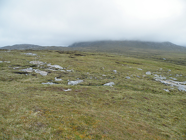
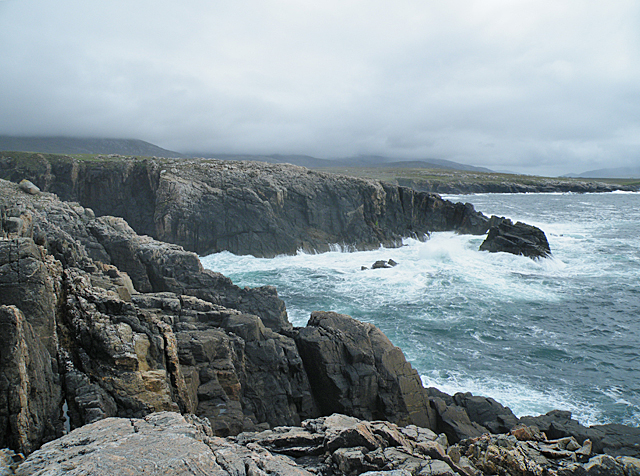
Sgeir a' Chota Mhòir is a small uninhabited island located off the coast of Ross-shire, Scotland. Also known as Little Coat Island, it is situated in the Inner Sound, between the mainland and the Isle of Skye. The island is roughly 1.5 acres in size and has an irregular shape.

Sgeir a' Chota Mhòir is characterized by its rugged and rocky terrain, with steep cliffs rising from the surrounding waters. The island is home to a variety of seabirds, including fulmars, kittiwakes, and guillemots, making it a popular spot for birdwatching enthusiasts. Its isolated location also provides a peaceful environment for these birds to nest undisturbed.

Access to Sgeir a' Chota Mhòir is primarily by boat, and there are no facilities or amenities available on the island. However, it is a frequent destination for boat trips and excursions, allowing visitors to appreciate its natural beauty and observe the abundance of wildlife.

The island's name, Sgeir a' Chota Mhòir, translates to "rock of the big coat" in English, although the origin and meaning of this name remain unclear. Despite its lack of human habitation, the island holds historical significance, with evidence of prehistoric settlements and structures found in the vicinity.

Overall, Sgeir a' Chota Mhòir is a remote and picturesque island that offers a unique opportunity to experience Scotland's natural beauty and observe its diverse wildlife.

If you have any feedback on the listing, please let us know in the comments section below.

Sgeir a' Chota Mhòir Images

Images are sourced within 2km of 58.14069/-7.1167182 or Grid Reference NA9928. Thanks to Geograph Open Source API. All images are credited.

Road, Peat Cuttings and Moorland
Houses at Islibhig An interesting juxtaposition of old and new.
Houses at Islibhig
An interesting juxtaposition of old and new.
Small pond beside the road to Islibhig This probably represents the site of a small quarry cut for stone when the road was being constructed.
Small pond beside the road to Islibhig
This probably represents the site of a small quarry cut for stone when the road was being constructed.
Geodh' an Fhithich Sea Stacks
Not Much of a View In clear weather there would be a view across the square towards Mealaisbhal. It might even be worth walking another couple of hundred metres to get Loch Sanndabhat in view. As it is, cloud base is not much higher than 150 metres above sea level, and all that is visible is a swathe of wet bog interspersed with glaciated outcrops of Lewisian gneiss.
Not Much of a View
In clear weather there would be a view across the square towards Mealaisbhal. It might even be worth walking another couple of hundred metres to get Loch Sanndabhat in view. As it is, cloud base is not much higher than 150 metres above sea level, and all that is visible is a swathe of wet bog interspersed with glaciated outcrops of Lewisian gneiss.
Rubh' an Taroin headland
Rubh' an Taroin
Rubh' an Taroin
Coastal moor at Mullach an Tàroin
Aird Feinis A deep rock pool in a cleft on the top of Aird Feinis.
Aird Feinis
A deep rock pool in a cleft on the top of Aird Feinis.
Cairn on Aird Feinis A cairn marks the highest point on the relatively level summit of Aird Feinis, with Aird Mangarstadh in the background.
Cairn on Aird Feinis
A cairn marks the highest point on the relatively level summit of Aird Feinis, with Aird Mangarstadh in the background.
Boulder-strewn Hillside These strange rounded boulders lie on the hill slope above the road opposite Aird Feinis. They have been rounded and polished by the movement of ice during the last Ice Age, which ended about 10,000 years ago.
Boulder-strewn Hillside
These strange rounded boulders lie on the hill slope above the road opposite Aird Feinis. They have been rounded and polished by the movement of ice during the last Ice Age, which ended about 10,000 years ago.
Geodha an Fhithich Several ridges of rock have been eroded to form a series of jagged rock stacks north of Aird Feinis.
Geodha an Fhithich
Several ridges of rock have been eroded to form a series of jagged rock stacks north of Aird Feinis.
Geodha an Fhithich Several ridges of rock have been eroded to form a series of jagged rock stacks north of Aird Feinis.
Geodha an Fhithich
Several ridges of rock have been eroded to form a series of jagged rock stacks north of Aird Feinis.
Geodha an Fhithich The sea north of Aird Feinis is studded with jagged sea stacks formed from granite intruded into the local Lewisian gneiss.
Geodha an Fhithich
The sea north of Aird Feinis is studded with jagged sea stacks formed from granite intruded into the local Lewisian gneiss.
Roseroot (Sedum rosea) This plant needs the shelter of the crevices between the stones on the clifftop at Aird Feinis.
Roseroot (Sedum rosea)
This plant needs the shelter of the crevices between the stones on the clifftop at Aird Feinis.
Aird Feinis The vegetation on this patch on the clifftop has been blown clean away by storms. Thrift (Armeria maritima) is recolonising the sand, and will eventually form a new sward.
Aird Feinis
The vegetation on this patch on the clifftop has been blown clean away by storms. Thrift (Armeria maritima) is recolonising the sand, and will eventually form a new sward.
Geological Conundrum This feature on Aird Feinis is significant, because the dark vein can be shown to cut across the gneiss, therefore proving the relative ages of the different rocks. The whole formation is a shear zone. Geologist for scale.
Geological Conundrum
This feature on Aird Feinis is significant, because the dark vein can be shown to cut across the gneiss, therefore proving the relative ages of the different rocks. The whole formation is a shear zone. Geologist for scale.
Aird Feinis Cliffs on the north side of Aird Feinis are battered by the sea in a strong westerly wind.
Aird Feinis
Cliffs on the north side of Aird Feinis are battered by the sea in a strong westerly wind.
Show me another place!

Sgeir a' Chota Mhòir is located at Grid Ref: NA9928 (Lat: 58.14069, Lng: -7.1167182)

Unitary Authority: Na h-Eileanan an Iar

Police Authority: Highlands and Islands

What 3 Words

///outbound.milder.recover. Near Carloway, Na h-Eileanan Siar

Related Wikis

Brenish

Brenish (Scottish Gaelic: Brèinis) is a small village situated on the west coast of the Isle of Lewis, which is part of the Outer Hebrides of Scotland...

Stac Dhòmhnaill Chaim

Stac Dhòmnuill Chaim, or Stac Dhòmhnaill Chaim, or Stac Domhnuill Chaim, is a fortified promontory located near Mangursta (or Mangersta, Scottish Gaelic...

Game pieces of the Lewis chessmen hoard

The game pieces of the Lewis chessmen hoard consist of ninety-three game pieces of the Lewis chessmen found on the Isle of Lewis in the Outer Hebrides...

Mealista

Mealista (Scottish Gaelic: Mealasta) was a township in the west of the Isle of Lewis. It is currently largely uninhabited due to the Highland Clearances...

Nearby Amenities

Located within 500m of 58.14069,-7.1167182
Passing Place
Lat/Long: 58.1391766/-7.1088886
Place: locality
Lat/Long: 58.1371216/-7.1171225
The data included in this document is from www.openstreetmap.org. The data is made available under ODbL.

Have you been to Sgeir a' Chota Mhòir?

Leave your review of Sgeir a' Chota Mhòir below (or comments, questions and feedback).