Ibbot Royd Clough

Valley in Yorkshire

England

Ibbot Royd Clough

The Rochdale Canal at Hebden Bridge
The Rochdale Canal at Hebden Bridge Credit: Dave Pickersgill

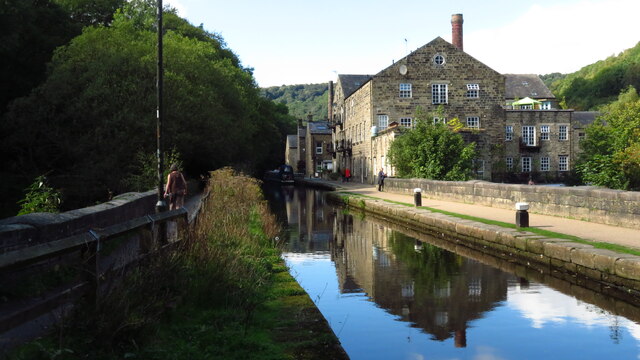
Ibbot Royd Clough is a picturesque valley located in Yorkshire, England. Nestled amidst the rolling hills of the Pennines, this hidden gem offers a tranquil and idyllic escape from the bustling city life. The valley is situated in the Calderdale district, specifically in the larger village of Hebden Bridge.

Characterized by its lush greenery and natural beauty, Ibbot Royd Clough is a popular destination for nature lovers and outdoor enthusiasts. The valley is home to a diverse range of flora and fauna, including ancient woodlands and meandering streams. The surrounding hills provide stunning panoramic views, making it a haven for hikers and photographers.

The valley is also renowned for its historic significance. The remnants of old mills and industrial buildings are scattered throughout the area, showcasing the region's rich industrial heritage. The clough itself was once a hub of activity, with water-powered mills operating along its banks.

Ibbot Royd Clough offers a variety of recreational activities for visitors to enjoy. The valley provides ample opportunities for walking, cycling, and picnicking, with several well-maintained trails and pathways. The peaceful atmosphere and serene surroundings make it an ideal spot for relaxation and rejuvenation.

In addition to its natural beauty, Ibbot Royd Clough is conveniently located near the charming village of Hebden Bridge. Here, visitors can explore quaint shops, cafes, and galleries, or take a leisurely stroll along the Rochdale Canal.

Overall, Ibbot Royd Clough is a hidden gem that showcases the picturesque beauty and rich history of Yorkshire. Whether you're seeking a peaceful retreat or an outdoor adventure, this valley is sure to captivate and enchant all who visit.

If you have any feedback on the listing, please let us know in the comments section below.

Ibbot Royd Clough Images

Images are sourced within 2km of 53.745918/-2.0029802 or Grid Reference SD9927. Thanks to Geograph Open Source API. All images are credited.

The Rochdale Canal at Hebden Bridge
Bridgegate
Bridgegate
The White Swan
The White Swan
Shoulder Of Mutton
Shoulder Of Mutton
Canal lock
Canal lock
Canal view
Canal view
The Flying Saucer at Hebden Bridge Cafe and studio in old canal warehouse
The Flying Saucer at Hebden Bridge
Cafe and studio in old canal warehouse
Northgate View along Northgate towards the main village
Northgate
View along Northgate towards the main village
From above the church tower Picture taken from my DJi Mini drone of the top of the church tower, the new graveyard just beyond, and in the far distance Whiteley Arches rail bridge in the green Calder Valley.
From above the church tower
Picture taken from my DJi Mini drone of the top of the church tower, the new graveyard just beyond, and in the far distance Whiteley Arches rail bridge in the green Calder Valley.
Whitehall Farm archway Archway marking the entrance to Whitehall Farm, inscribed on the lintel are the initials JB standing for John Bentley, once owner of the farm and the date of 1578..
Whitehall Farm archway
Archway marking the entrance to Whitehall Farm, inscribed on the lintel are the initials JB standing for John Bentley, once owner of the farm and the date of 1578..
View along the church roof A view along the roof of the church of St Thomas the Apostle, looking towards the village of Old town in the distance.
View along the church roof
A view along the roof of the church of St Thomas the Apostle, looking towards the village of Old town in the distance.
Heptonstall from Smeekin Hill Taken from the Smeekin Hill/Wadsworth war memorial looking across Hebden Dale towards Heptonstall and in the far distance the peace monument of Stoodley Pike Monument.
Heptonstall from Smeekin Hill
Taken from the Smeekin Hill/Wadsworth war memorial looking across Hebden Dale towards Heptonstall and in the far distance the peace monument of Stoodley Pike Monument.
Looking up the church tower Looking up the tower of the church of St Thomas the Apostle.
Looking up the church tower
Looking up the tower of the church of St Thomas the Apostle.
Halifax Road at Calderside View from rail line on Whiteley Arches
Halifax Road at Calderside
View from rail line on Whiteley Arches
The aqueduct carrying the Rochdale Canal over the Calder at Hebden Bridge The Rochdale Canal runs for 33 miles between Manchester and Sowerby Bridge in West Yorkshire, UK. In Sowerby Bridge it connects with the Calder and Hebble Navigation. In Manchester it connects with the Ashton and Bridgewater Canals. 

The canal was opened between Sowerby Bridge and Todmorden and from Manchester to Rochdale in 1799 and between Todmorden and Rochdale in 1805. Most of the canal was closed in 1952. Restoration work began in late 1980s and by  1996 the canal was opened to navigation once again between Sowerby Bridge and the summit level. The canal was re-opened to navigation along its entire length in July 2002 and forms part of the South Pennine Ring. 

<span class="nowrap"><a title="http://www.penninewaterways.co.uk/rochdale/index.htm" rel="nofollow ugc noopener" href="http://www.penninewaterways.co.uk/rochdale/index.htm">Link</a><img style="margin-left:2px;" alt="External link" title="External link - shift click to open in new window" src="https://s1.geograph.org.uk/img/external.png" width="10" height="10"/></span>
The aqueduct carrying the Rochdale Canal over the Calder at Hebden Bridge
The Rochdale Canal runs for 33 miles between Manchester and Sowerby Bridge in West Yorkshire, UK. In Sowerby Bridge it connects with the Calder and Hebble Navigation. In Manchester it connects with the Ashton and Bridgewater Canals. The canal was opened between Sowerby Bridge and Todmorden and from Manchester to Rochdale in 1799 and between Todmorden and Rochdale in 1805. Most of the canal was closed in 1952. Restoration work began in late 1980s and by 1996 the canal was opened to navigation once again between Sowerby Bridge and the summit level. The canal was re-opened to navigation along its entire length in July 2002 and forms part of the South Pennine Ring. LinkExternal link
Seat at eastern end of Horsehold Wood & view over Calderside A seat with a view.
Seat at eastern end of Horsehold Wood & view over Calderside
A seat with a view.
View towards Hebden Bridge from eastern end of Horsehold Wood
Rochdale Canal at Hebden Bridge
Show me another place!

Ibbot Royd Clough is located at Grid Ref: SD9927 (Lat: 53.745918, Lng: -2.0029802)

Division: West Riding

Unitary Authority: Calderdale

Police Authority: West Yorkshire

What 3 Words

///pasting.bitter.motivator. Near Hebden Bridge, West Yorkshire

Related Wikis

Birchcliffe Baptist Church

Birchcliffe Baptist Church is a redundant Baptist chapel in the town of Hebden Bridge, West Yorkshire, England. It was founded by Daniel Taylor in 1764...

Wadsworth, West Yorkshire

Wadsworth is a civil parish in the Metropolitan Borough of Calderdale in West Yorkshire, England. It has a population of 1,456, increasing to 1,603 at...

Hebden Royd

Hebden Royd is a civil parish in the Metropolitan Borough of Calderdale in West Yorkshire, England. According to the 2001 census it had a population of...

Hebden Bridge

Hebden Bridge is a market town in the Calderdale district of West Yorkshire, England. It is in the Upper Calder Valley, 8 miles (13 km) west of Halifax...

Old Town, West Yorkshire

Old Town is a village in Calderdale, West Yorkshire, England. It is situated on a hilltop above Hebden Bridge and across the Hebden valley from Heptonstall...

Hebden Bridge Town Hall

Hebden Bridge Town Hall, formerly Hebden Bridge Council Offices, is a municipal building in St George's Street, Hebden Bridge, West Yorkshire, England...

Battle of Heptonstall

The Battle of Heptonstall occurred in November 1643 during the First English Civil War at Hebden Bridge and Heptonstall, Yorkshire. During the battle,...

Hebden Bridge Picture House

Hebden Bridge Picture House in Hebden Bridge, West Yorkshire, is one of the last remaining council-owned cinemas in Britain. Together with the adjacent...

Nearby Amenities

Located within 500m of 53.745918,-2.0029802
Dodd Naze
Place: locality
Lat/Long: 53.742644/-2.0050169
Bus Stop
Keighley Road Lees Road
Bench: no
Bin: no
Bus: yes
Lit: yes
Local Ref: 45018996
Naptan AtcoCode: 450018996
Naptan Bearing: N
Naptan CommonName: Keighley Road Lees Road
Naptan Crossing: Lees Road
Naptan Indicator: Stop 45018996
Naptan Notes: OSR taken place 061005
Naptan PlusbusZoneRef: LEEDS
Naptan ShortCommonName: Lees Road
Naptan Street: Keighley Road
Naptan Verified: no
Public Transport: platform
Shelter: no
Source: naptan_import
Tactile Paving: no
Lat/Long: 53.7460724/-2.0097046
Manor Drive
Local Ref: 45024450
Naptan AtcoCode: 450024450
Naptan Bearing: S
Naptan BusStopType: CUS
Naptan CommonName: Manor Drive
Naptan Crossing: Wadsworth Lane
Naptan Indicator: Stop 45024450
Naptan PlusbusZoneRef: LEEDS
Naptan ShortCommonName: Wadsworth Lane
Naptan Street: Manor Drive
Naptan Verified: no
Source: naptan_import
Lat/Long: 53.742082/-2.0021075
Keighley Road Lees Road
Local Ref: 45025582
Naptan AtcoCode: 450025582
Naptan Bearing: S
Naptan BusStopType: CUS
Naptan CommonName: Keighley Road Lees Road
Naptan Crossing: Lee Road
Naptan Indicator: Stop 45025582
Naptan PlusbusZoneRef: LEEDS
Naptan ShortCommonName: Lees Road
Naptan Street: Keighley Road
Naptan Verified: no
Source: naptan_import
Lat/Long: 53.7460005/-2.0095378
Foster Lane
Local Ref: 45024605
Naptan AtcoCode: 450024605
Naptan Bearing: S
Naptan BusStopType: CUS
Naptan CommonName: Foster Lane
Naptan Crossing: Nr-At Hirst Grove
Naptan Indicator: Stop 45024605
Naptan PlusbusZoneRef: LEEDS
Naptan ShortCommonName: Foster Lane
Naptan Street: Foster Lane
Naptan Verified: no
Source: naptan_import
Lat/Long: 53.7429538/-2.0023502
Bus Stop
Hirst Grove Wadsworth Lane
Bench: no
Bin: no
Bus: yes
Local Ref: 45025270
Naptan AtcoCode: 450025270
Naptan Bearing: N
Naptan CommonName: Hirst Grove Wadsworth Lane
Naptan Crossing: Wadsworth Lane
Naptan Indicator: Stop 45025270
Naptan Landmark: Community Centre
Naptan PlusbusZoneRef: LEEDS
Naptan ShortCommonName: Dodd Naze
Naptan Street: Hirst Grove
Naptan Verified: no
Public Transport: platform
Shelter: no
Source: naptan_import
Lat/Long: 53.7421628/-2.0041696
Bus Stop
Keighley Road Nutclough Road
Bench: no
Bin: no
Bus: yes
Lit: yes
Local Ref: 45024963
Naptan AtcoCode: 450024963
Naptan Bearing: SW
Naptan CommonName: Keighley Road Nutclough Road
Naptan Crossing: Nutclough Road
Naptan Indicator: Stop 45024963
Naptan PlusbusZoneRef: LEEDS
Naptan ShortCommonName: Nutclough Road
Naptan Street: Keighley Road
Naptan Verified: no
Public Transport: platform
Shelter: no
Source: naptan_import
Tactile Paving: no
Lat/Long: 53.744059/-2.0095829
Barrier: stile
Foot: yes
Lat/Long: 53.7442712/-2.002106
Dodd Naze Community Centre
Building: public
Lat/Long: 53.7423807/-2.0040646
Entrance: yes
Lat/Long: 53.7435861/-2.0083991
Post Box
Brand: Royal Mail
Brand Wikidata: Q638098
Brand Wikipedia: en:Royal Mail
Collection Times: Mo-Fr 09:00; Sa 07:00; Su off
Operator: Royal Mail
Operator Wikidata: Q638098
Post Box Type: lamp
Ref: HX7 299
Royal Cypher: EIIR
Royal Cypher Wikidata: Q33102113
Lat/Long: 53.741949/-2.0040983
Post Box
Collection Times: Mo-Fr 09:00; Sa 07:00
Post Box Type: wall
Ref: HX7 183
Royal Cypher: EVIIR
Royal Cypher Wikidata: Q33102324
Lat/Long: 53.7458911/-2.0096087
Generator Method: photovoltaic
Generator Output Electricity: yes
Generator Source: solar
Generator Type: solar_photovoltaic_panel
Power: generator
Lat/Long: 53.7456343/-2.0105696
Barrier: stile
Lat/Long: 53.7472142/-2.006388
The data included in this document is from www.openstreetmap.org. The data is made available under ODbL.

Have you been to Ibbot Royd Clough?

Leave your review of Ibbot Royd Clough below (or comments, questions and feedback).