Swinden Clough

Valley in Lancashire Pendle

England

Swinden Clough

Old Milestone by the A682, Barrowford Carved stone post by the A682, in parish of BARROWFORD (PENDLE District), Gisburn Road, opposite No. 129, fixed into and protruding above wall at edge of Pendle Water, on East side of road. Gisburn Wedge, erected by the Gisburne & Long Preston turnpike trust in the 19th century. 

Inscription reads:-
: To / Burnley / 5 / Miles : : 1863 : : To / Gisburne / 7 / Miles :

Grade II listed. 
List Entry Number: 1361705 <span class="nowrap"><a title="https://historicengland.org.uk/listing/the-list/list-entry/1361705" rel="nofollow ugc noopener" href="https://historicengland.org.uk/listing/the-list/list-entry/1361705">Link</a><img style="margin-left:2px;" alt="External link" title="External link - shift click to open in new window" src="https://s1.geograph.org.uk/img/external.png" width="10" height="10"/></span>

Milestone Society National ID: LA_GNBU07.
Old Milestone by the A682, Barrowford Credit: Martin Coates

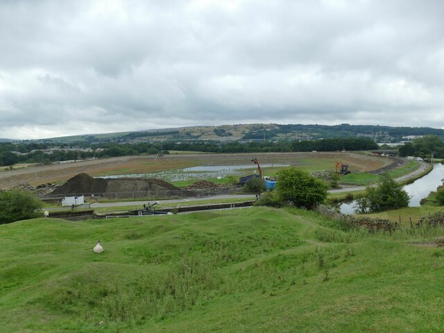
Swinden Clough is a picturesque valley located in the county of Lancashire, England. Situated in the southern part of the county, it is nestled within the larger Pennine Hills, providing a stunning backdrop of natural beauty. The valley stretches for approximately 1.5 miles and is known for its rugged landscape, with steep slopes and rocky outcrops.

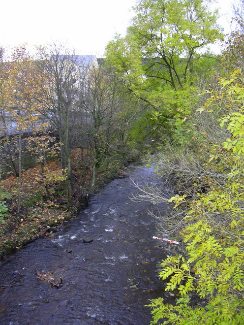
The main feature of Swinden Clough is the river that runs through it, aptly named Swinden Water. The river flows gently along the valley floor, meandering through the lush greenery and adding to the tranquility of the surroundings. The river is a haven for wildlife, with various species of fish, birds, and small mammals calling it home.

The valley is a popular destination for outdoor enthusiasts and nature lovers alike. It offers a range of activities such as hiking, birdwatching, and fishing. The network of footpaths crisscrossing the valley provides opportunities for walks of varying difficulty levels, catering to both casual strollers and more experienced hikers.

The flora and fauna in Swinden Clough are diverse and abundant. The valley is home to a variety of plant species, including wildflowers, ferns, and mosses. The wooded areas are dominated by oak, birch, and beech trees, providing shelter and nesting sites for numerous bird species.

Swinden Clough's natural beauty and tranquil atmosphere make it a popular spot for those seeking respite from the hustle and bustle of everyday life. Whether it's exploring the winding paths, admiring the wildlife, or simply enjoying the peacefulness of the surroundings, visitors to Swinden Clough are sure to find solace in this idyllic Lancashire valley.

If you have any feedback on the listing, please let us know in the comments section below.

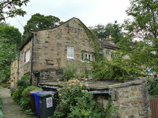
Swinden Clough Images

Images are sourced within 2km of 53.849711/-2.2024643 or Grid Reference SD8639. Thanks to Geograph Open Source API. All images are credited.
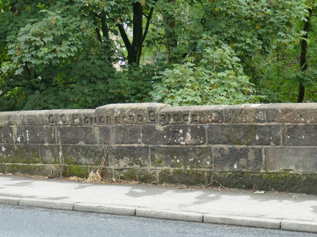
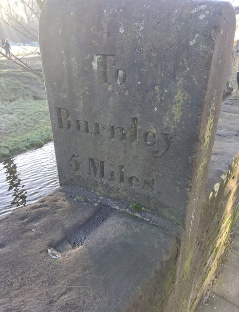
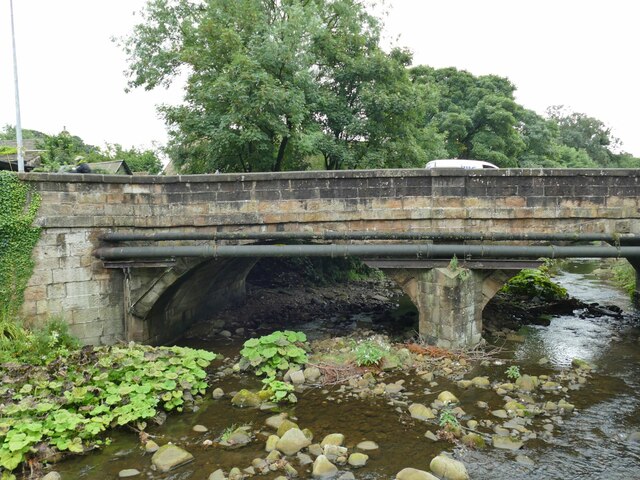
Old Milestone by the A682, Barrowford Carved stone post by the A682, in parish of BARROWFORD (PENDLE District), Gisburn Road, opposite No. 129, fixed into and protruding above wall at edge of Pendle Water, on East side of road. Gisburn Wedge, erected by the Gisburne & Long Preston turnpike trust in the 19th century. 

Inscription reads:-
: To / Burnley / 5 / Miles : : 1863 : : To / Gisburne / 7 / Miles :

Grade II listed. 
List Entry Number: 1361705 <span class="nowrap"><a title="https://historicengland.org.uk/listing/the-list/list-entry/1361705" rel="nofollow ugc noopener" href="https://historicengland.org.uk/listing/the-list/list-entry/1361705">Link</a><img style="margin-left:2px;" alt="External link" title="External link - shift click to open in new window" src="https://s1.geograph.org.uk/img/external.png" width="10" height="10"/></span>

Milestone Society National ID: LA_GNBU07.
Old Milestone by the A682, Barrowford
Carved stone post by the A682, in parish of BARROWFORD (PENDLE District), Gisburn Road, opposite No. 129, fixed into and protruding above wall at edge of Pendle Water, on East side of road. Gisburn Wedge, erected by the Gisburne & Long Preston turnpike trust in the 19th century. Inscription reads:- : To / Burnley / 5 / Miles : : 1863 : : To / Gisburne / 7 / Miles : Grade II listed. List Entry Number: 1361705 LinkExternal link Milestone Society National ID: LA_GNBU07.
Barrowford Reservoir, drained The reservoir, which serves the Leeds and Liverpool Canal rather than public water supply, was not empty because of the 2022 drought, but because it had been deliberately drained down in autumn 2021 for a year-long contract to stabilise the embankment. A short section of the canal nearby was also drained for maintenance at the same time.
Barrowford Reservoir, drained
The reservoir, which serves the Leeds and Liverpool Canal rather than public water supply, was not empty because of the 2022 drought, but because it had been deliberately drained down in autumn 2021 for a year-long contract to stabilise the embankment. A short section of the canal nearby was also drained for maintenance at the same time.
Caspers Fold, Francis Avenue, Higherford The house bears a datestone of 2000.
Caspers Fold, Francis Avenue, Higherford
The house bears a datestone of 2000.
Defibrillator on the corner of Francis Avenue These devices are normally found on the wall of public buildings, but here is one on a post by the street in an area of housing.
Defibrillator on the corner of Francis Avenue
These devices are normally found on the wall of public buildings, but here is one on a post by the street in an area of housing.
Bus shelter and old phone box Located at the junction of Barnoldswick Road and Gisburn Road in Higherford.  The phone box appears disused. Street furniture here also includes a grit bin and litter bin.
Bus shelter and old phone box
Located at the junction of Barnoldswick Road and Gisburn Road in Higherford. The phone box appears disused. Street furniture here also includes a grit bin and litter bin.
Road sign in Higherford Located at the junction of Barnoldswick Road and Gisburn Road; the sign also points to Nelson in the opposite direction. Milestone Society National ID: LA_SD8640
Road sign in Higherford
Located at the junction of Barnoldswick Road and Gisburn Road; the sign also points to Nelson in the opposite direction. Milestone Society National ID: LA_SD8640
Old mill, Gisburn Road, Higherford The 1912 map shows this as a corn mill. It's probably too high above the river to have been water powered. Now in private hands, a 2015 proposal for 'brownfield' development on the site was not approved. <a href="https://www.geograph.org.uk/photo/506484">SD8640 : Old mill on Gisburn Road, Barrowford</a> shows it from the other direction.
Old mill, Gisburn Road, Higherford
The 1912 map shows this as a corn mill. It's probably too high above the river to have been water powered. Now in private hands, a 2015 proposal for 'brownfield' development on the site was not approved. SD8640 : Old mill on Gisburn Road, Barrowford shows it from the other direction.
Former Catholic church, Gisburn Road, Higherford The name on the sign board is 'Parish of the Good Shepherd' but other contributors name the building itself as St Peter & St Paul's. A local website says that it was built from 1897, the first service registers being from 1902, but closed for worship in 2019. It appears no new use has been found yet.
Former Catholic church, Gisburn Road, Higherford
The name on the sign board is 'Parish of the Good Shepherd' but other contributors name the building itself as St Peter & St Paul's. A local website says that it was built from 1897, the first service registers being from 1902, but closed for worship in 2019. It appears no new use has been found yet.
Detail of Gisburn Road bridge, Higherford An inscription 'C C Higherford Bridge' and an OS cut benchmark (shown on the 1912 map as 437.9ft). It was built in 1807. See <a href="https://www.geograph.org.uk/photo/4956971">SD8640 : Higherford Bridge and Mill</a> for a side view of the bridge.
Detail of Gisburn Road bridge, Higherford
An inscription 'C C Higherford Bridge' and an OS cut benchmark (shown on the 1912 map as 437.9ft). It was built in 1807. See SD8640 : Higherford Bridge and Mill for a side view of the bridge.
Former cotton mill, Higherford Listed grade II (List entry 1271499) where it is dated to 'c.1844, incorporating elements of an earlier C19 mill, with further additions of 1882, and C20 alterations'. The main weaving shed seen in <a href="https://www.geograph.org.uk/photo/4957250">SD8640 : Grimshaw's (Higherford) Mill</a> is claimed to be the oldest surviving example of its kind. Note the iron beam and high level doorway, presumably for loading bales of cotton from road vehicles.
Former cotton mill, Higherford
Listed grade II (List entry 1271499) where it is dated to 'c.1844, incorporating elements of an earlier C19 mill, with further additions of 1882, and C20 alterations'. The main weaving shed seen in SD8640 : Grimshaw's (Higherford) Mill is claimed to be the oldest surviving example of its kind. Note the iron beam and high level doorway, presumably for loading bales of cotton from road vehicles.
Listed cottages, Foreside, Higherford Listed grade II (List entry 1073432) where the oldest is dated to 1755.
Listed cottages, Foreside, Higherford
Listed grade II (List entry 1073432) where the oldest is dated to 1755.
Crowtree Cottage, Foreside, Higherford Listed grade II (List entry 1273168) where it is dated to the mid-18th century. The large number of windows at first floor level suggests it was used for weaving.
Crowtree Cottage, Foreside, Higherford
Listed grade II (List entry 1273168) where it is dated to the mid-18th century. The large number of windows at first floor level suggests it was used for weaving.
Th' Owd Brig at Higherford This is described by Margaret Slack (Ref.1) as 'One of the most attractive packhorse bridges in [the Pennines] ...standing on the direct line of the Roman Road from Castercliffe to Ribchester. It was crossed by teams of packhorses bringing coal from near Gisburn and ... lime from Lothersdale.' She adds that the date of the bridge is not known with certainty, but probably late 16th century. 

The bridge crosses Pendle Water, draining the steep eastern scarp of that great hill, and subject to flash flooding; Slack relates a story that a bell used to hang from the bridge that rang a warning when water approached flood level.

Listed grade II *(List entry 1273194) and a Scheduled Monument. Originally it would have had no, or very low, parapets to allow ponies with low-hanging panniers to cross; the present parapets were added in 1815.

(1) 'The Bridges of Lancashire and Yorkshire', Margaret Slack, 1986.
Th' Owd Brig at Higherford
This is described by Margaret Slack (Ref.1) as 'One of the most attractive packhorse bridges in [the Pennines] ...standing on the direct line of the Roman Road from Castercliffe to Ribchester. It was crossed by teams of packhorses bringing coal from near Gisburn and ... lime from Lothersdale.' She adds that the date of the bridge is not known with certainty, but probably late 16th century. The bridge crosses Pendle Water, draining the steep eastern scarp of that great hill, and subject to flash flooding; Slack relates a story that a bell used to hang from the bridge that rang a warning when water approached flood level. Listed grade II *(List entry 1273194) and a Scheduled Monument. Originally it would have had no, or very low, parapets to allow ponies with low-hanging panniers to cross; the present parapets were added in 1815. (1) 'The Bridges of Lancashire and Yorkshire', Margaret Slack, 1986.
Gisburn Road bridge, Higherford This road bridge over Pendle Water was erected in 1807 to supersede the old packhorse bridge, which still stands but closed to motor traffic <a href="https://www.geograph.org.uk/photo/7265480">SD8640 : Th' Owd Brig at Higherford</a>.
Gisburn Road bridge, Higherford
This road bridge over Pendle Water was erected in 1807 to supersede the old packhorse bridge, which still stands but closed to motor traffic SD8640 : Th' Owd Brig at Higherford.
The Old Bridge Inn, Higherford Actually close to the 'new' bridge, not the old one <a href="https://www.geograph.org.uk/photo/7265480">SD8640 : Th' Owd Brig at Higherford</a>.
The Old Bridge Inn, Higherford
Actually close to the 'new' bridge, not the old one SD8640 : Th' Owd Brig at Higherford.
Former Methodist Sunday School, Higherford Dated 1834, in residential use since 1972 (source: <span class="nowrap"><a title="https://www.flickr.com/photos/rossendalewadey/5885068439" rel="nofollow ugc noopener" href="https://www.flickr.com/photos/rossendalewadey/5885068439">Link</a><img style="margin-left:2px;" alt="External link" title="External link - shift click to open in new window" src="https://s1.geograph.org.uk/img/external.png" width="10" height="10"/></span> ). An early 20th century map shows a tram terminus outside; the tramway from Nelson opened in the early years of the century and closed in 1934.
Former Methodist Sunday School, Higherford
Dated 1834, in residential use since 1972 (source: LinkExternal link ). An early 20th century map shows a tram terminus outside; the tramway from Nelson opened in the early years of the century and closed in 1934.
Former Methodist Sunday School, Higherford - datestone Wesleyan Methodist Sunday School Built by Subscription AD 1834. See <a href="https://www.geograph.org.uk/photo/7265486">SD8640 : Former Methodist Sunday School, Higherford</a> for context.
Former Methodist Sunday School, Higherford - datestone
Wesleyan Methodist Sunday School Built by Subscription AD 1834. See SD8640 : Former Methodist Sunday School, Higherford for context.
Fold, Gisburn Road, Higherford Mid-18th century stone cottages, grade II listed (list entry 1073435).
Fold, Gisburn Road, Higherford
Mid-18th century stone cottages, grade II listed (list entry 1073435).
Show me another place!

Swinden Clough is located at Grid Ref: SD8639 (Lat: 53.849711, Lng: -2.2024643)

Administrative County: Lancashire

District: Pendle

Police Authority: Lancashire

What 3 Words

///cabbage.bordering.moment. Near Barrowford, Lancashire

Related Wikis

Nelson power station

Nelson power station supplied electricity to the town of Nelson, Lancashire and the surrounding area from 1892 to 1960. The power station was owned and...

Pendle (UK Parliament constituency)

Pendle is a constituency in Lancashire represented in the House of Commons of the UK Parliament since 2010 by Andrew Stephenson, a Conservative. The constituency...

Colne Water

Colne Water is a river in eastern Lancashire. It is approximately 5.0 miles (7.987 km) long and has a catchment area excluding its major tributaries (the...

Bott Lane Halt railway station

Bott Lane Halt railway station was a station on the East Lancashire line between Nelson and Colne, in Lancashire, England. It was situated off Bott House...

Pendle Vale College

Pendle Vale College is a mixed 11 to 16 comprehensive school located in Nelson, Lancashire. == History == The school initially opened in 2006 as part of...

Colne Primet Academy

Colne Primet Academy (formerly Colne Primet High School) is a mixed secondary school located in Colne in the English county of Lancashire.Previously a...

Ss John Fisher and Thomas More Roman Catholic High School

Ss John Fisher and Thomas More RC High School is a coeducational secondary school located in Colne in the English county of Lancashire. The school is named...

Walverden Water

Walverden Water is a minor river in Lancashire, England. It is approximately 2.6 miles (4.2 km) long and has a catchment area of 5.04 square miles (1,304...

Nearby Amenities

Located within 500m of 53.849711,-2.2024643
Source: NPE
Waterway: lock_gate
Lat/Long: 53.8521775/-2.2024214
Source: NPE
Waterway: lock_gate
Lat/Long: 53.8527342/-2.2014502
Source: NPE
Waterway: lock_gate
Lat/Long: 53.8528759/-2.2012114
Source: NPE
Waterway: lock_gate
Lat/Long: 53.8523174/-2.2021898
Ref: 49
Waterway: lock_gate
Lat/Long: 53.8539845/-2.2007013
Fuel
Asda
Brand: Asda
Brand Wikidata: Q297410
Brand Wikipedia: en:Asda
Contact Website: https://storelocator.asda.com/north-west/colne/unit-1-swinden-retail-park
Opening Hours: 24/7
Operator: Asda Stores Ltd
Lat/Long: 53.8490076/-2.1949477
Barrier: bollard
Lat/Long: 53.8461734/-2.2010795
Barrier: bollard
Lat/Long: 53.846243/-2.2011653
Power: tower
Lat/Long: 53.847044/-2.2006946
Power: tower
Lat/Long: 53.8482355/-2.2050398
Post Box
Check Date: 2021-04-13
Collection Times: Mo-Fr 09:00, Sa 07:00
Operator: Royal Mail
Ref: BB9 175D
Ref Signed: no
Royal Cypher: EIIR
Royal Cypher Wikidata: Q33102113
Lat/Long: 53.8456377/-2.2050298
Addr Housenumber: 109
Lat/Long: 53.8530016/-2.1984726
Addr Housenumber: 102 ?
Lat/Long: 53.8526032/-2.1985626
Greenfield Road Local Nature Reserve
Information: board;map
Tourism: information
Lat/Long: 53.8524471/-2.1982428
Trees & Woodland
Information: board
Tourism: information
Lat/Long: 53.852433/-2.1979519
River & Pond
Information: board
Tourism: information
Lat/Long: 53.8523429/-2.1968127
Bus Stop
Swinden Hall Road
Bench: no
Naptan AtcoCode: 2500LAA07251
Naptan NaptanCode: lanjadja
Public Transport: platform
Shelter: no
Tactile Paving: no
Lat/Long: 53.8455386/-2.205239
Bus Stop
Swinden Hall Road
Bench: no
Naptan AtcoCode: 2500LAA08198
Naptan NaptanCode: lanjwadm
Public Transport: platform
Shelter: no
Tactile Paving: no
Lat/Long: 53.8455134/-2.2050933
Bus Stop
Regent Street
Public Transport: platform
Lat/Long: 53.846606/-2.2042459
Bus Stop
Edward Street
Bench: yes
Naptan AtcoCode: 2500LAA08196
Naptan NaptanCode: lanjwadg
Public Transport: platform
Shelter: yes
Tactile Paving: no
Lat/Long: 53.8477862/-2.2027287
Bus Stop
Edward Street
Bench: no
Public Transport: platform
Shelter: no
Tactile Paving: no
Lat/Long: 53.847742/-2.2026459
Bus Stop
Asda
Bench: yes
Naptan AtcoCode: 2500LAA08195
Naptan NaptanCode: lanjwada
Public Transport: platform
Shelter: yes
Tactile Paving: no
Lat/Long: 53.8498613/-2.1963864
Bus Stop
Asda
Bench: yes
Naptan AtcoCode: 2500LAA08194
Naptan NaptanCode: lanjtwtw
Public Transport: platform
Shelter: yes
Tactile Paving: no
Lat/Long: 53.8497756/-2.1957345
Steven Burke Sports Hub
Leisure: sports_centre
Lat/Long: 53.849783/-2.2082308
Pets at Home
Addr City: Colne
Addr Housename: Unit 3, Corporation Street Retail Park
Addr Postcode: BB8 8LU
Addr Street: Corporation Street
Brand: Pets at Home
Brand Wikidata: Q7179258
Brand Wikipedia: en:Pets at Home
Phone: +44 345 606 0727
Shop: pet
Website: https://community.petsathome.com/store/colne/
Lat/Long: 53.848482/-2.196853
Poundland
Addr City: Colne
Addr Housename: Unit B Boundary Retail Park
Addr Postcode: BB8 8LU
Addr Street: Corporation Street
Brand: Poundland
Brand Wikidata: Q1434528
Brand Wikipedia: en:Poundland
Opening Hours: Mo-Fr 08:30-19:30, Sa 09:00-19:00, Su 10:00-16:00
Phone: +44 1282 867741
Shop: variety_store
Lat/Long: 53.8483396/-2.1967163
B&M Bargains
Addr City: Colne
Addr Housename: Unit 4
Addr Postcode: BB8 8LU
Addr Street: Corporation Street
Brand: B&M Bargains
Brand Wikidata: Q4836931
Brand Wikipedia: en:B & M
Contact Website: https://www.bmstores.co.uk/stores/colne-14
Opening Hours: Mo-Fr 09:00-20:00, Sa 09:00-18:00, Su 10:00-16:00
Shop: variety_store
Lat/Long: 53.848194/-2.1965553
Bicycle Parking
Bicycle Parking: stands
Capacity: 4
Covered: yes
Fee: no
Lat/Long: 53.8491007/-2.1962039
Bicycle Parking
Bicycle Parking: stands
Capacity: 6
Covered: yes
Fee: no
Lat/Long: 53.8493334/-2.1961695
Pharmacy
Brand: Asda
Brand Wikidata: Q297410
Brand Wikipedia: en:Asda
Contact Phone: +44 1282 870156
Contact Website: https://storelocator.asda.com/north-west/colne/unit-1-swinden-retail-park/pharmacy
Fixme: Location not accurate
Operator: Asda Stores Ltd
Lat/Long: 53.8492377/-2.1973756
Brand: Asda
Brand Wikidata: Q297410
Brand Wikipedia: en:Asda
Contact Phone: +44 1282 873512
Contact Website: https://storelocator.asda.com/north-west/colne/unit-1-swinden-retail-park/opticians
Fixme: Location not accurate
Operator: Asda Stores Ltd
Shop: optician
Lat/Long: 53.8493295/-2.1974802
Cafe
Brand: Asda
Brand Wikidata: Q297410
Brand Wikipedia: en:Asda
Contact Phone: +44 1282 870156
Contact Website: https://storelocator.asda.com/north-west/colne/unit-1-swinden-retail-park/cafe
Drinking Water Refill: yes
Drinking Water Refill Network: Refill
Fixme: Location not accurate
Internet Access: wlan
Internet Access Fee: no
Opening Hours Covid19: Mo-Su off
Operator: Asda Stores Ltd
Lat/Long: 53.8494118/-2.1975741
Atm
Covered: yes
Drive Through: no
Network: Link
Operator: Barclays
Lat/Long: 53.8494971/-2.1963101
Barrier: cycle_barrier
Lat/Long: 53.8484459/-2.2061708
Barrier: cycle_barrier
Lat/Long: 53.8487455/-2.2066896
Bicycle Parking
Access: yes
Bicycle Parking: stands
Capacity: 12
Covered: no
Fee: no
Lat/Long: 53.8482957/-2.1956197
Phone
Emergency: phone
Indoor: no
Operator: National Highways
Operator Type: government
Operator Wikidata: Q5760006
Ref: 4408 A
Lat/Long: 53.8531903/-2.2034774
Phone
Emergency: phone
Indoor: no
Operator: National Highways
Operator Type: government
Operator Wikidata: Q5760006
Ref: 4408 B
Lat/Long: 53.8529694/-2.2033026
The data included in this document is from www.openstreetmap.org. The data is made available under ODbL.

Have you been to Swinden Clough?

Leave your review of Swinden Clough below (or comments, questions and feedback).