Hazely Cleuch

Valley in Roxburghshire

Scotland

Hazely Cleuch

Ordnance Survey Flush Bracket G2363 This can be found on the wall of the School House - a private dwelling - at Cogsmill.
For more detail see : <span class="nowrap"><a title="http://www.bench-marks.org.uk/bm14459" rel="nofollow ugc noopener" href="http://www.bench-marks.org.uk/bm14459">Link</a><img style="margin-left:2px;" alt="External link" title="External link - shift click to open in new window" src="https://s1.geograph.org.uk/img/external.png" width="10" height="10"/></span>
Ordnance Survey Flush Bracket G2363 Credit: Peter Wood

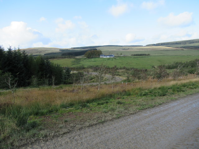
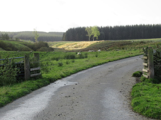
Hazely Cleuch is a picturesque valley located in the region of Roxburghshire, Scotland. Situated in the southern part of the country, the valley is known for its stunning natural beauty and rich history.

Surrounded by rolling hills and lush greenery, Hazely Cleuch offers visitors a tranquil escape from the busy city life. The valley is characterized by its meandering streams, dense forests, and vibrant flora and fauna. It is a haven for nature enthusiasts, hikers, and birdwatchers, who can explore the numerous walking trails and enjoy the breathtaking views.

In addition to its natural wonders, Hazely Cleuch also has a fascinating history. The valley is home to several ancient archaeological sites, including prehistoric stone circles and burial mounds. These remnants of the past provide a glimpse into the lives of the early inhabitants of the area.

Hazely Cleuch is also known for its charming villages, where visitors can experience the warm hospitality of the locals. The small communities nestled within the valley offer traditional Scottish cuisine, quaint accommodations, and a chance to immerse oneself in the local culture.

Overall, Hazely Cleuch is a hidden gem in Roxburghshire, offering a combination of natural beauty and historical significance. Whether it's exploring the enchanting landscapes, delving into the past, or simply enjoying the serenity of the countryside, Hazely Cleuch is a destination that captivates all who visit.

If you have any feedback on the listing, please let us know in the comments section below.

Hazely Cleuch Images

Images are sourced within 2km of 55.363214/-2.7333291 or Grid Reference NT5307. Thanks to Geograph Open Source API. All images are credited.

Ordnance Survey Flush Bracket G2363 This can be found on the wall of the School House - a private dwelling - at Cogsmill.
For more detail see : <span class="nowrap"><a title="http://www.bench-marks.org.uk/bm14459" rel="nofollow ugc noopener" href="http://www.bench-marks.org.uk/bm14459">Link</a><img style="margin-left:2px;" alt="External link" title="External link - shift click to open in new window" src="https://s1.geograph.org.uk/img/external.png" width="10" height="10"/></span>
Ordnance Survey Flush Bracket G2363
This can be found on the wall of the School House - a private dwelling - at Cogsmill. For more detail see : LinkExternal link
View east off the B6399
View north-east off the B6399
Valley of the Cogsmill Burn The Cogsmill Burn is a tributary of the Slitrig Water which in turn is a tributary of the River Teviot in Hawick.
Valley of the Cogsmill Burn
The Cogsmill Burn is a tributary of the Slitrig Water which in turn is a tributary of the River Teviot in Hawick.
South Berryfell Farm from the air South Berryfell Farm is in the centre of the photo.
South Berryfell Farm from the air
South Berryfell Farm is in the centre of the photo.
Cogsmill Hall, Whitlawhaugh, near Hawick The colour scheme has changed since this 2007 photo <a href="https://www.geograph.org.uk/photo/549765">NT5108 : Cogsmill Hall, Whitlawhaugh, Hawick</a>.
Cogsmill Hall, Whitlawhaugh, near Hawick
The colour scheme has changed since this 2007 photo NT5108 : Cogsmill Hall, Whitlawhaugh, Hawick.
Meadowland at Cogsmill, from the B6399
Cattle grid on the B6399 There are several such grids on this road though some have been tarmacked over.
Cattle grid on the B6399
There are several such grids on this road though some have been tarmacked over.
Plantation near South Berryfell Farm
View towards Earlside Covert on White Hill
View towards Adderston Shiels Adderston Shiels is hidden by the trees in the centre of the picture.
View towards Adderston Shiels
Adderston Shiels is hidden by the trees in the centre of the picture.
The flanks of Haits Hill
South Berryfell Farm Largely hidden by trees.
South Berryfell Farm
Largely hidden by trees.
Land below Berryfell Hill Largely rough grazing with some conifer plantations.
Land below Berryfell Hill
Largely rough grazing with some conifer plantations.
Lurgiescleuch near Hobkirk I hurried on - unsure of which lurgie it was but taking no chances!
Lurgiescleuch near Hobkirk
I hurried on - unsure of which lurgie it was but taking no chances!
Lurgiescleuch road crossing Pines Burn by causeway Beautifully surfaced road all the way to this remote dwelling.
Lurgiescleuch road crossing Pines Burn by causeway
Beautifully surfaced road all the way to this remote dwelling.
Cleugh containing Whisky Sike's waters near Lurgiescleuch in the Scottish Borders
Whisky through the rocks near Hobkirk Culvert under the roadway.
Whisky through the rocks near Hobkirk
Culvert under the roadway.
Show me another place!

Hazely Cleuch is located at Grid Ref: NT5307 (Lat: 55.363214, Lng: -2.7333291)

Unitary Authority: The Scottish Borders

Police Authority: The Lothians and Scottish Borders

What 3 Words

///umbrellas.moons.ratio. Near Hawick, Scottish Borders

Related Wikis

Shankend

Shankend Manor was a sixteenth-century mansion located some six miles (ten kilometres) south of Hawick, close to Whitrope Siding in Scotland. It was constructed...

Shankend railway station

Shankend railway station served the hamlet of Shankend, Scottish Borders, Scotland from 1862 to 1969 on the Border Union Railway. == History == The station...

Stobs railway station

Stobs railway station served the hamlet of Barnes, Scottish Borders, Scotland from 1862 to 1969 on the Border Union Railway. == History == The station...

Stobs Military Camp

Stobs Camp is a military and internment camp located just outside Hawick in the Scottish Borders. It is an internationally important site due to its level...

Have you been to Hazely Cleuch?

Leave your review of Hazely Cleuch below (or comments, questions and feedback).