Barrington

Settlement in Somerset South Somerset

England

Barrington

Barrington Court The Tudor manor house.
Barrington Court Credit: Andrew Longton

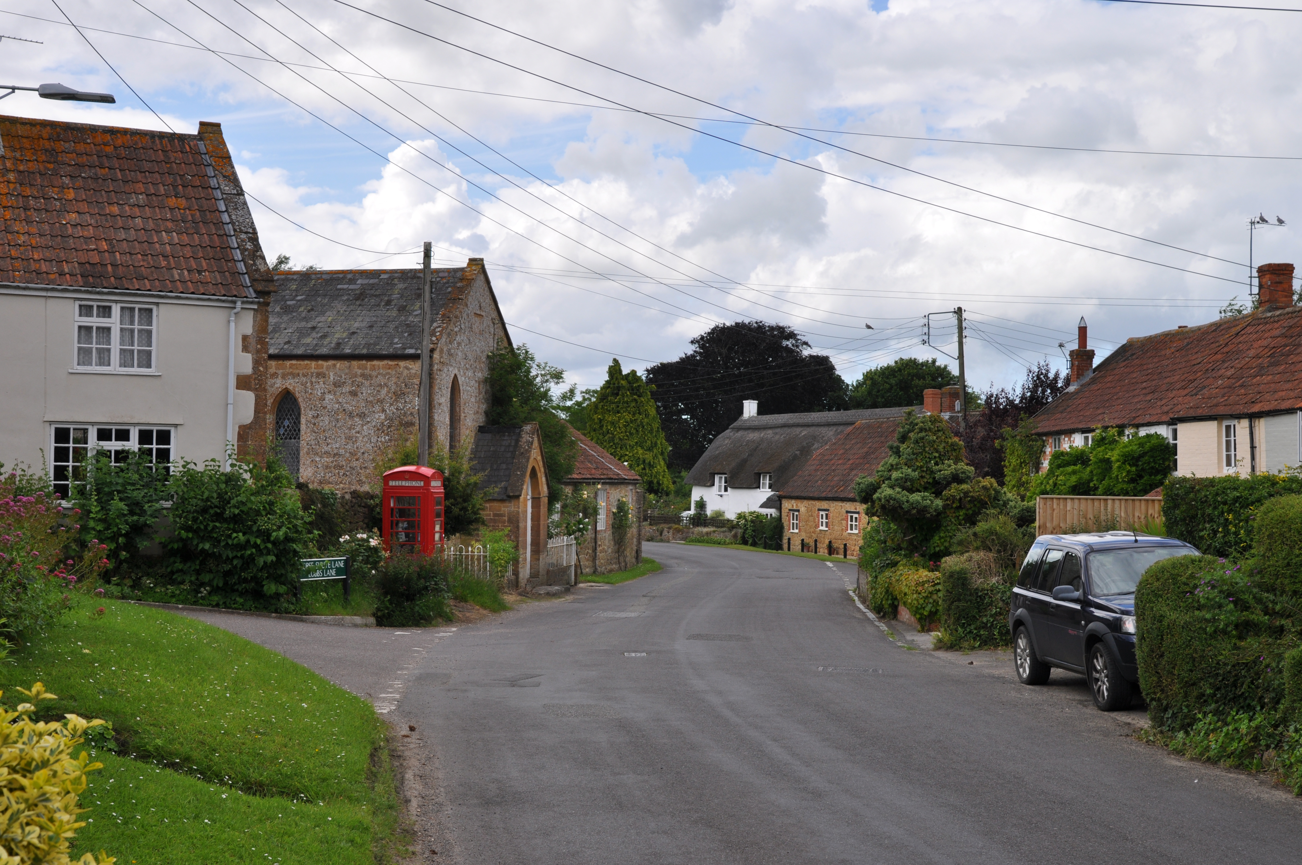
Barrington is a small village located in the county of Somerset, England. Situated approximately 8 miles south-east of the town of Taunton, it lies within the district of South Somerset. The village is set amidst picturesque countryside, surrounded by rolling hills and farmland.

With a population of around 500 residents, Barrington exudes a peaceful and close-knit community atmosphere. The village is known for its charming architecture, featuring many historic buildings constructed from local Ham stone, which give a distinct character to the area.

At the heart of Barrington stands the 13th-century Church of St Mary, a beautiful example of medieval architecture that showcases the village's rich history. The church is often visited by tourists and locals alike, who appreciate its intricate detailing and serene atmosphere.

Barrington also boasts an array of amenities, including a village hall, a primary school, and a local pub, providing residents with essential services and a sense of community. The village is well-connected to nearby towns and cities via road links, with the A303 and A358 providing easy access to Taunton and the rest of Somerset.

The surrounding countryside of Barrington offers numerous opportunities for outdoor activities, such as hiking, cycling, and horse riding, with an abundance of footpaths and bridleways to explore. The village is also within close proximity to the stunning Blackdown Hills Area of Outstanding Natural Beauty, providing residents and visitors with further opportunities to enjoy the natural landscape.

Overall, Barrington is a quintessential English village that offers a tranquil setting, a strong community spirit, and easy access to the beautiful Somerset countryside.

If you have any feedback on the listing, please let us know in the comments section below.

Barrington Images

Images are sourced within 2km of 50.959998/-2.871805 or Grid Reference ST3818. Thanks to Geograph Open Source API. All images are credited.

Barrington Court The Tudor manor house.
Barrington Court
The Tudor manor house.
Stocklinch Ottersey church Remote from its village
Stocklinch Ottersey church
Remote from its village
Barrington: church St Mary’s church stands above much of the village and dates from the 13th century. With an octagonal crossing tower and transepts the church was nevertheless a subsidiary foundation to South Petherton
Barrington: church
St Mary’s church stands above much of the village and dates from the 13th century. With an octagonal crossing tower and transepts the church was nevertheless a subsidiary foundation to South Petherton
Ilminster, Barrington Court A quaint photograph of roses round the door on some of the outbuildings
Ilminster, Barrington Court
A quaint photograph of roses round the door on some of the outbuildings
Ilminster, Barrington Court Garden Lovely gardens and water features are prominent in this National Trust Garden.
Ilminster, Barrington Court Garden
Lovely gardens and water features are prominent in this National Trust Garden.
Strode House, Barrington Court from the Garden The garden at Barrington Court was inspired by Gertrude Jekyll. See <span class="nowrap"><a title="http://www.nationaltrust.org.uk/main/w-vh/w-visits/w-findaplace/w-barringtoncourt/w-barrington_court-a_brief_history.htm" rel="nofollow ugc noopener" href="http://www.nationaltrust.org.uk/main/w-vh/w-visits/w-findaplace/w-barringtoncourt/w-barrington_court-a_brief_history.htm">Link</a><img style="margin-left:2px;" alt="External link" title="External link - shift click to open in new window" src="https://s1.geograph.org.uk/img/external.png" width="10" height="10"/></span>
Strode House, Barrington Court from the Garden
The garden at Barrington Court was inspired by Gertrude Jekyll. See LinkExternal link
Puckington: Gummer’s Lane A track and public footpath to Stocklinch. Possibly an old way as it defines the parish boundary with Stocklinch. Looking south east
Puckington: Gummer’s Lane
A track and public footpath to Stocklinch. Possibly an old way as it defines the parish boundary with Stocklinch. Looking south east
Barrington Cricket Field Barrington Cricket Field adjacent to Barrington Court
Barrington Cricket Field
Barrington Cricket Field adjacent to Barrington Court
St Andrews Church Puckington A lovely church set well back from the road, easily missed.
St Andrews Church Puckington
A lovely church set well back from the road, easily missed.
St Andrews Church Puckington
Church Notice Board Puckington
Manor Farmhouse Puckington Manor Farmhouse Puckington adjacent to the church, was possibly the vicarage at one time
Manor Farmhouse Puckington
Manor Farmhouse Puckington adjacent to the church, was possibly the vicarage at one time
Refurbished bridge over the Westport canal at Westport From the sign, it has probably been 'improved' to take vastly more weight than was dreampt of when the canal was built.
Refurbished bridge over the Westport canal at Westport
From the sign, it has probably been 'improved' to take vastly more weight than was dreampt of when the canal was built.
Derelict Westport canal at Westport
Strode House, Barrington Court Strode House, built by William Strode in 1647 as stables for Barrington Court, converted to domestic use by Forbes in 1921-5.
Strode House, Barrington Court
Strode House, built by William Strode in 1647 as stables for Barrington Court, converted to domestic use by Forbes in 1921-5.
Through the gateway Barrington Court gardens
Poppy head in Barrington Court  Garden
Poppy head in Barrington Court Garden
Atherstone Hill Cattle graze on the steep slopes of Atherstone Hill above the Isle valley. Hurcott Copse is in the background. Taken from a gateway beside the lane between Atherstone and Hurcott.
Atherstone Hill
Cattle graze on the steep slopes of Atherstone Hill above the Isle valley. Hurcott Copse is in the background. Taken from a gateway beside the lane between Atherstone and Hurcott.
Show me another place!

Barrington is located at Grid Ref: ST3818 (Lat: 50.959998, Lng: -2.871805)

Administrative County: Somerset

District: South Somerset

Police Authority: Avon and Somerset

What 3 Words

///streak.tomato.waxes. Near South Petherton, Somerset

Nearby Locations

Oak Hill Barrington

Related Wikis

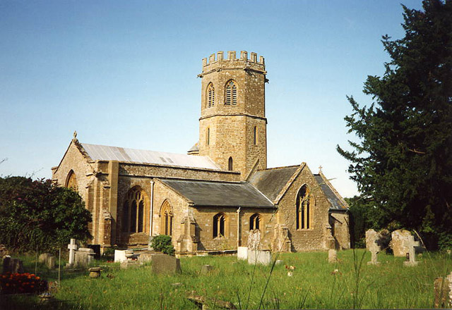
Church of St Mary the Virgin, Barrington

The Church of St Mary the Virgin in Barrington, Somerset, England dates from the 13th century and has been designated as a Grade I listed building.St Mary...

Barrington, Somerset

Barrington is a village and civil parish, situated 10 miles (16.1 km) south east of Taunton and 10 miles (16.1 km) west of Yeovil in Somerset, England...
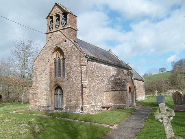
Stocklinch

Stocklinch is a village and civil parish 3.5 miles (6 km) north-east of Ilminster in the South Somerset district of Somerset, England. == History == The...

Barrington Court

Barrington Court is a Tudor manor house begun around 1538 and completed in the late 1550s, with a vernacular stable court (1675), situated in Barrington...

Church of St Andrew, Puckington

The Anglican Church of St Andrew in Puckington, Somerset, England, was built in the 13th century. It is a Grade II* listed building. == History == The...

Church of St Mary Magdalene, Stocklinch

The Church of St Mary Magdalen in Stocklinch, Somerset, England, dates from the 13th century. It is recorded in the National Heritage List for England...

Puckington

Puckington is a village and civil parish, situated 10 miles (16 km) south-east of Taunton and 10 miles (16 km) west of Yeovil in the South Somerset district...
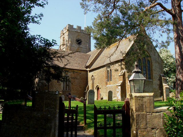
Shepton Beauchamp

Shepton Beauchamp is a village and civil parish, 1 mile (2 km) from Barrington and 4 miles (6 km) north east of Ilminster between the Blackdown Hills and...

Nearby Amenities

Located within 500m of 50.959998,-2.871805
Barrington
Place: village
Wikidata: Q1455070
Wikipedia: en:Barrington, Somerset
Lat/Long: 50.9595461/-2.8712731
Pub
Barrington Boar
Lat/Long: 50.9595383/-2.87065
Post Box
Operator: Royal Mail
Operator Wikidata: Q638098
Lat/Long: 50.9589727/-2.8666098
Public Bookcase
Booth: K6
Disused Amenity: telephone
Listed Status: Grade II
Man Made: telephone_box
Public Bookcase Type: phone_box
Lat/Long: 50.95983/-2.8717016
Post Box
Operator: Royal Mail
Operator Wikidata: Q638098
Post Box Type: lamp
Ref: TA19 380
Royal Cypher: EIIR
Royal Cypher Wikidata: Q33102113
Lat/Long: 50.9618489/-2.8773802
Power: pole
Source: bing
Lat/Long: 50.9635456/-2.8674129
Power: pole
Source: bing
Lat/Long: 50.9628665/-2.8685045
Power: pole
Source: bing
Lat/Long: 50.9617752/-2.8743517
Power: pole
Source: bing
Lat/Long: 50.961477/-2.8718197
Poles: bipole
Power: pole
Source: bing
Lat/Long: 50.9613824/-2.8709427
Power: pole
Source: bing
Lat/Long: 50.9618698/-2.870138
Power: pole
Source: bing
Lat/Long: 50.9623597/-2.8693588
Power: pole
Source: bing
Transformer: distribution
Lat/Long: 50.961042/-2.8758363
Power: pole
Source: bing
Lat/Long: 50.9609296/-2.8766987
Power: pole
Source: bing
Lat/Long: 50.9607767/-2.8779875
The data included in this document is from www.openstreetmap.org. The data is made available under ODbL.

Have you been to Barrington?

Leave your review of Barrington below (or comments, questions and feedback).