Galley Hill

Hill, Mountain in Bedfordshire

England

Galley Hill

High Street, Sutton, Beds
High Street, Sutton, Beds Credit: Rodney Burton

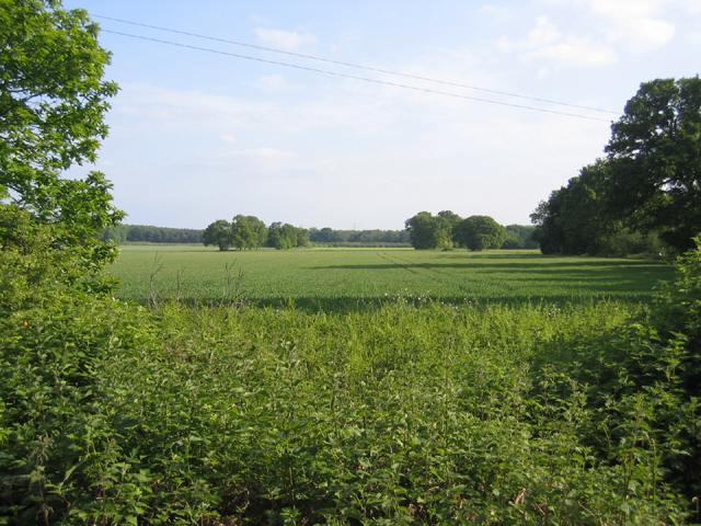
Galley Hill is a prominent hill located in the county of Bedfordshire, England. Situated just south of the town of Luton, it stands at an elevation of 131 meters (430 feet) above sea level, making it one of the highest points in the area. With its distinctive silhouette, Galley Hill is easily recognizable and has become a popular landmark.

The hill itself is part of the Chiltern Hills, a range of chalk hills that stretch across several counties in southern England. It is primarily composed of chalk and offers stunning panoramic views of the surrounding countryside. On a clear day, visitors to Galley Hill can see as far as the city of London, around 50 kilometers (31 miles) to the south.

The name "Galley Hill" is believed to have derived from "Gallow's Hill," as it was once the site of public executions. However, there is limited historical information about these events.

Today, Galley Hill is a popular destination for outdoor enthusiasts, hikers, and nature lovers alike. It is home to a diverse range of flora and fauna, including rare butterfly species. The hill is also crisscrossed by various footpaths and trails, providing ample opportunities for exploration.

In recent years, efforts have been made to preserve and enhance the natural beauty of Galley Hill. Local authorities have implemented measures to protect the wildlife and maintain the integrity of the landscape, ensuring that future generations can continue to enjoy this picturesque hill in Bedfordshire.

If you have any feedback on the listing, please let us know in the comments section below.

Galley Hill Images

Images are sourced within 2km of 52.120061/-0.22922366 or Grid Reference TL2148. Thanks to Geograph Open Source API. All images are credited.

High Street, Sutton, Beds
John o' Gaunt pub, Sutton, Beds on the High Street.
John o' Gaunt pub, Sutton, Beds
on the High Street.
All Saints' church, Sutton, Beds situated north of Church Road, built in the Early English and Decorated styles.
All Saints' church, Sutton, Beds
situated north of Church Road, built in the Early English and Decorated styles.
Ford and bridge, Sutton, Beds A medieval twin-arched packhorse bridge over Potton Brook, a tributary of the River Ivel, where High Street meets Church Road.
Ford and bridge, Sutton, Beds
A medieval twin-arched packhorse bridge over Potton Brook, a tributary of the River Ivel, where High Street meets Church Road.
Medieval packhorse bridge, Sutton, Beds now serving as a footbridge over the Potton Brook.
Medieval packhorse bridge, Sutton, Beds
now serving as a footbridge over the Potton Brook.
High Street, Sutton, Beds
Biggleswade Road, Sutton, Beds approaching the bend on the B1040 at Watermill Bridge.
Biggleswade Road, Sutton, Beds
approaching the bend on the B1040 at Watermill Bridge.
Pegnut Wood, Sutton, Beds A new poplar plantation to produce high quality timber, open to the public; view from the car park beside Sutton Road.
Pegnut Wood, Sutton, Beds
A new poplar plantation to produce high quality timber, open to the public; view from the car park beside Sutton Road.
Leaving Potton, Beds – view out of town along the Sutton Road.
Leaving Potton, Beds
– view out of town along the Sutton Road.
Standalone Farm drive, Sutton, Beds – view from Sutton Road.
Standalone Farm drive, Sutton, Beds
– view from Sutton Road.
Wrestlingworth Road, Potton, Beds
Winter wheat, Sutton, Beds on Fen Farm SW of Carthagena Road.
Winter wheat, Sutton, Beds
on Fen Farm SW of Carthagena Road.
Lupin crop, Sutton, Beds on sandy soils (Frilford series – argillic brown sands); view from Carthgena Road towards the wooded Greensand ridge.
Lupin crop, Sutton, Beds
on sandy soils (Frilford series – argillic brown sands); view from Carthgena Road towards the wooded Greensand ridge.
Entrance to bridleway, Sutton/Potton, Beds from Carthagena Road towards Galley Hill, forming the parish boundary.
Entrance to bridleway, Sutton/Potton, Beds
from Carthagena Road towards Galley Hill, forming the parish boundary.
St Mary's, Potton St Mary's is situated on a small hill on the edge of Potton. An ancient right of way (locally called the Church Causeway) leads from opposite the Church to the centre of Potton. The Church recently celebrated its 900th anniversary although the present building mostly originates from the 13th Century.
St Mary's, Potton
St Mary's is situated on a small hill on the edge of Potton. An ancient right of way (locally called the Church Causeway) leads from opposite the Church to the centre of Potton. The Church recently celebrated its 900th anniversary although the present building mostly originates from the 13th Century.
Sandy Heath TV Transmitter Sandy Heath TV transmitter (lots of information here: <span class="nowrap"><a title="http://tx.mb21.co.uk/gallery/gallerypage.php?txid=840" rel="nofollow ugc noopener" href="http://tx.mb21.co.uk/gallery/gallerypage.php?txid=840">Link</a><img style="margin-left:2px;" alt="External link" title="External link - shift click to open in new window" src="https://s1.geograph.org.uk/img/external.png" width="10" height="10"/></span> and here <span class="nowrap"><a title="https://www.thebigtower.com/live/SandyHeath/Index.htm" rel="nofollow ugc noopener" href="https://www.thebigtower.com/live/SandyHeath/Index.htm">Link</a><img style="margin-left:2px;" alt="External link" title="External link - shift click to open in new window" src="https://s1.geograph.org.uk/img/external.png" width="10" height="10"/></span> ) with Sandy Quarry in the foreground.
Sandy Heath TV Transmitter
Sandy Heath TV transmitter (lots of information here: LinkExternal link and here LinkExternal link ) with Sandy Quarry in the foreground.
Disused sand quarry The old sand quarry workings just to the south of the Sandy Heath transmitter.
Disused sand quarry
The old sand quarry workings just to the south of the Sandy Heath transmitter.
Potton Station Opened June 1862, close January 1968. See <span class="nowrap"><a title="http://www.disused-stations.org.uk/p/potton/index.shtml" rel="nofollow ugc noopener" href="http://www.disused-stations.org.uk/p/potton/index.shtml">Link</a><img style="margin-left:2px;" alt="External link" title="External link - shift click to open in new window" src="https://s1.geograph.org.uk/img/external.png" width="10" height="10"/></span> for the history of the station and associated railway line, photos etc.
Potton Station
Opened June 1862, close January 1968. See LinkExternal link for the history of the station and associated railway line, photos etc.
Show me another place!

Galley Hill is located at Grid Ref: TL2148 (Lat: 52.120061, Lng: -0.22922366)

Unitary Authority: Central Bedfordshire

Police Authority: Bedfordshire

What 3 Words

///pushover.presumes.intrigues. Near Potton, Bedfordshire

Related Wikis

BigglesFM

BigglesFM is a local radio station based in Potton. It started broadcasting a full-time service on 22 April 2011.The station plays both modern and older...

John O'Gaunt Golf Club

John O'Gaunt Golf Club is a golf club, located two-and-a-half miles to the north-east of Biggleswade, Bedfordshire, England, just north of the village...

Potton United F.C.

Potton United F.C. is an English football club based in Potton, Bedfordshire. The club are currently members of the Spartan South Midlands League Premier...

Church of All Saints, Sutton, Bedfordshire

Church of All Saints is a Grade I listed church in Sutton, Bedfordshire, England. It became a listed building on 31 October 1966. == See also == Grade...

Related Videos

Walking UK's Magnificent Woodlands | RSPB The Lodge (Part 2)

Welcome to Part 2, where I continue walking around some of the most magnificent woodlands that the UK has to offer at RSPB ...

Exploring the UK's AMAZING Woodlands | RSPB The Lodge (Part 1)

Today, I explored some of the most amazing woodlands that the UK has to offer at RSPB The Lodge in Bedfordshire. This nature ...

Swinging From a Tree Sandy woods. #deepdalewoods #grandchildren

Hi welcome to my channel. In this video I am out for the afternoon with my grandson in deepdale woods built on hills of sand with ...

Practice your craft and learn

This is a vid I should have put up last week before my new yrs day vid but it still counts..this video is about knowledge and ...

Nearby Amenities

Located within 500m of 52.120061,-0.22922366
Barrier: stile
Foot: yes
Source: GPS
Lat/Long: 52.1232538/-0.2245657
Historic: milestone
Lat/Long: 52.1168711/-0.2246457
The data included in this document is from www.openstreetmap.org. The data is made available under ODbL.

Have you been to Galley Hill?

Leave your review of Galley Hill below (or comments, questions and feedback).