Barland

Settlement in Radnorshire

Wales

Barland

Evenjobb entrance sign
Evenjobb entrance sign Credit: Alex McGregor

Barland is a small village situated in the historic county of Radnorshire, Wales. It is located about 6 miles southeast of the market town of Knighton and is surrounded by picturesque rolling hills and farmland. The village, with a population of around 200, is known for its tranquil and idyllic setting, making it a popular destination for nature lovers and those seeking a peaceful retreat.

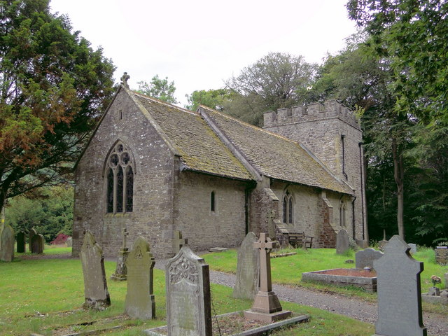
The main focal point of Barland is its charming 12th-century church, dedicated to St. Michael, which stands proudly at the heart of the village. The church is a fine example of Norman architecture, featuring a beautiful tower and intricate stone carvings. It holds regular services and is also a significant historical landmark in the area.

Despite its small size, Barland boasts a vibrant community spirit, evident in the various local events and activities that take place throughout the year. The village hall serves as a hub for social gatherings, offering a range of clubs and societies catering to different interests. These include gardening clubs, book clubs, and art groups, providing opportunities for residents to socialize and pursue their hobbies.

In terms of amenities, Barland has a well-stocked village shop, providing essential groceries and everyday items. However, for a wider range of services, residents often rely on nearby towns such as Knighton or Llandrindod Wells, which offer a more comprehensive selection of shops, restaurants, and healthcare facilities.

Overall, Barland offers a peaceful and close-knit community atmosphere, combined with stunning natural surroundings, making it an attractive place to live or visit for those seeking a rural retreat.

If you have any feedback on the listing, please let us know in the comments section below.
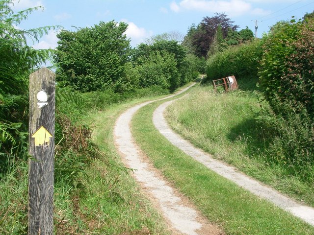
Barland Images

Images are sourced within 2km of 52.251466/-3.055269 or Grid Reference SO2862. Thanks to Geograph Open Source API. All images are credited.

Evenjobb entrance sign
Access road near Evenjobb
St Peter, Evenjobb Expensive building designed by T.H. Wyatt and built between 1866 and 1870. 'Solid and ugly' says the Powys Pevsner - perhaps a little harshly.
St Peter, Evenjobb
Expensive building designed by T.H. Wyatt and built between 1866 and 1870. 'Solid and ugly' says the Powys Pevsner - perhaps a little harshly.
St Peter, Evenjobb High quality building - an excellent example of High Victorian design and craftsmanship. Architect : T.H. Wyatt, 1866-70.
St Peter, Evenjobb
High quality building - an excellent example of High Victorian design and craftsmanship. Architect : T.H. Wyatt, 1866-70.
St Peter, Evenjobb From the East.
St Peter, Evenjobb
From the East.
St Peter, Evenjobb
St Peter, Evenjobb
St Michael, Knill Very much tucked away, overlooking the grounds of Knill Court.
St Michael, Knill
Very much tucked away, overlooking the grounds of Knill Court.
St Michael, Knill From the North East, showing the Norman window. Very secluded, but still very much in use.
St Michael, Knill
From the North East, showing the Norman window. Very secluded, but still very much in use.
Churchyard Cross, Knill Almost complete cross - only the cross at the top seems to be a later restoration.
Churchyard Cross, Knill
Almost complete cross - only the cross at the top seems to be a later restoration.
St Michael, Knill The Victorian interior, with a display of the hatchments of the Walshams of Knill Court.
St Michael, Knill
The Victorian interior, with a display of the hatchments of the Walshams of Knill Court.
St Michael, Knill The interior, looking West - with enough seating for about ten times the population of the village.
St Michael, Knill
The interior, looking West - with enough seating for about ten times the population of the village.
War Memorial tablet, Knill Commemorates the Great War, but without names. Knill was one of the few Thankful Villages whose menfolk all returned from the First World War. An early example of 'I counted them out and I counted them all back again ....'
War Memorial tablet, Knill
Commemorates the Great War, but without names. Knill was one of the few Thankful Villages whose menfolk all returned from the First World War. An early example of 'I counted them out and I counted them all back again ....'
Cottage at Thorn
Cottage at Thorn
House in Evenjobb A very interesting part stone, part half-timber house on a road junction in the village of Evenjobb.
House in Evenjobb
A very interesting part stone, part half-timber house on a road junction in the village of Evenjobb.
Burfa Bank Parked a short way up forestry track, then a first corner heading NW a muddy track heads upward through trees bluebells and nettles. Top is grassy ridge.
Name: Burfa Bank
Hill number: 5226
Height: 313m / 1027ft
Area: 31B: Welshpool to Hay-on-Wye
Class: Hu
Grid ref: SO 28266 60997
Summit feature: no feature: grass
Drop: 104m
Col: 209m  SO280617
Burfa Bank
Parked a short way up forestry track, then a first corner heading NW a muddy track heads upward through trees bluebells and nettles. Top is grassy ridge. Name: Burfa Bank Hill number: 5226 Height: 313m / 1027ft Area: 31B: Welshpool to Hay-on-Wye Class: Hu Grid ref: SO 28266 60997 Summit feature: no feature: grass Drop: 104m Col: 209m SO280617
On Offa's Dyke Path S of Pen Offa near Evenjobb
Burfa Farm near Lower Harpton
Show me another place!

Barland is located at Grid Ref: SO2862 (Lat: 52.251466, Lng: -3.055269)

Unitary Authority: Powys

Police Authority: Dyfed Powys

What 3 Words

///distract.ribcage.wimp. Near Presteigne, Powys

Related Wikis

Burfa Castle

Burfa Castle (also known as Burfa Hillfort, Burfa Bank Hillfort, or Burfa Camp) is an Iron Age hillfort near the tiny town of Old Radnor, Radnorshire in...

Lower Harpton

Lower Harpton is a settlement and civil parish about 2.5 miles of Knighton, in the county of Herefordshire, England. In 2001, the parish had a population...

Knill

Knill is a village and civil parish in Herefordshire, England. == History == Recorded in the Domesday Book of 1086 as Chenille (from the Old English meaning...

Beggar's Bush, Powys

Beggar's Bush is a hamlet in the community of Pencraig, Powys, Wales, which is 55 miles (88 km) from Cardiff and 137 miles (220 km) from London. A round...

Nearby Amenities

Located within 500m of 52.251466,-3.055269
Barrier: stile
Lat/Long: 52.2495981/-3.0618202
Barrier: stile
Lat/Long: 52.248782/-3.0605559
Barrier: stile
Lat/Long: 52.2484272/-3.0600627
The data included in this document is from www.openstreetmap.org. The data is made available under ODbL.

Have you been to Barland?

Leave your review of Barland below (or comments, questions and feedback).