Black Hill

Hill, Mountain in Worcestershire Malvern Hills

England

Black Hill

Hounds on Broad Down View north to the Herefordshire Beacon with Clutter's Cave just ahead. The Ledbury Hunt is scouring the Eastnor estate off to the left and these hounds have come up to the hilltop to check things out.
Hounds on Broad Down Credit: Trevor Rickard

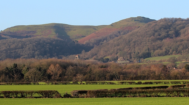
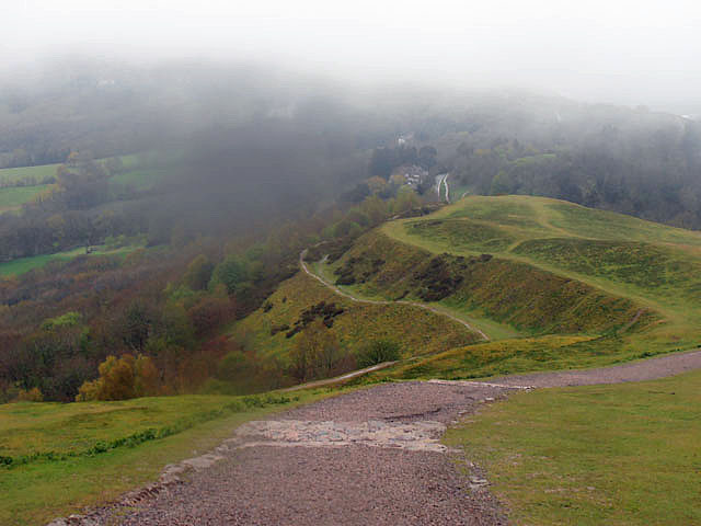
Black Hill is a prominent hill located in Worcestershire, England. Situated on the eastern side of the county near the town of Bromsgrove, it forms part of the Clent Hills range. Standing at an elevation of 325 meters (1,066 feet), it offers breathtaking views of the surrounding countryside and is a popular destination for outdoor enthusiasts.

The hill is predominantly composed of sandstone, which gives it a distinctive reddish-brown color. It is covered in heather and bracken, creating a picturesque landscape, particularly during the summer months when the heather blooms in vibrant purples and pinks. The area is also home to a variety of wildlife, including birds, small mammals, and reptiles.

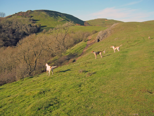
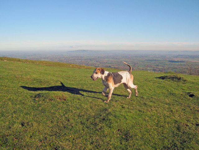
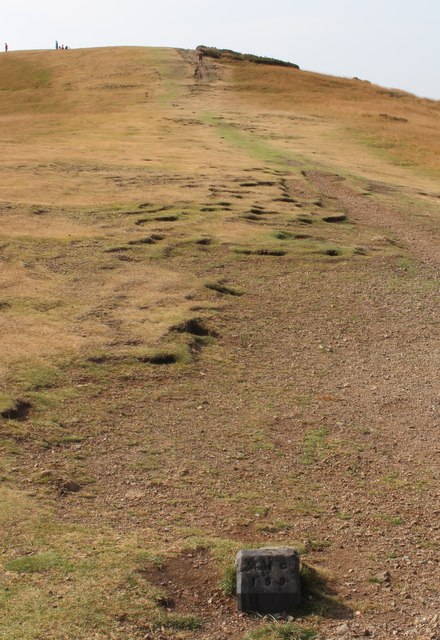
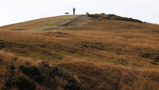
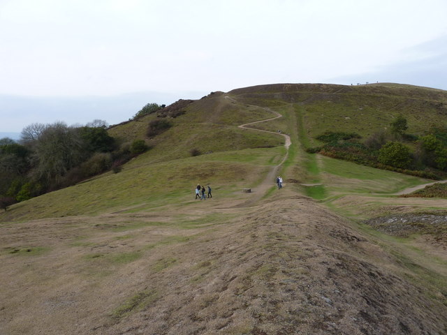
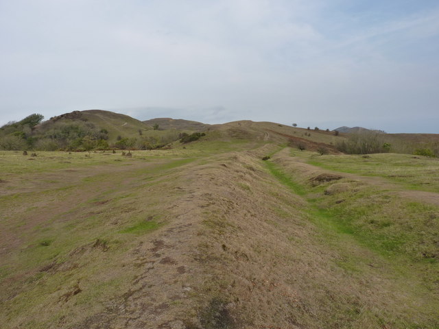
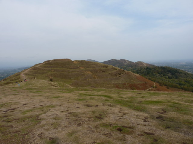
Black Hill is a favorite spot for hikers and walkers, with numerous footpaths crisscrossing the area. The hill is easily accessible, with parking available nearby, and there are several routes to reach the summit. The most popular trail starts from the Nimmings Wood car park and ascends through woodlands before opening up to panoramic views from the top.

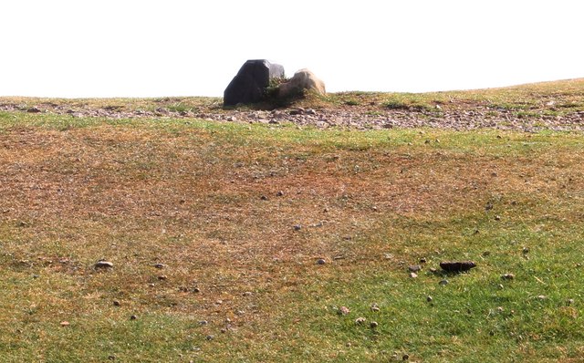
At the summit, visitors can find a trig point, which is a concrete pillar used in surveying. This marks the highest point of the hill and provides a reference for mapmakers and surveyors. On clear days, it is possible to see as far as the Malvern Hills and the Welsh mountains from this vantage point.

Overall, Black Hill is a stunning natural feature in Worcestershire, attracting nature lovers and outdoor enthusiasts with its scenic beauty and panoramic views.

If you have any feedback on the listing, please let us know in the comments section below.

Black Hill Images

Images are sourced within 2km of 52.069535/-2.3392735 or Grid Reference SO7641. Thanks to Geograph Open Source API. All images are credited.

Hounds on Broad Down View north to the Herefordshire Beacon with Clutter's Cave just ahead. The Ledbury Hunt is scouring the Eastnor estate off to the left and these hounds have come up to the hilltop to check things out.
Hounds on Broad Down
View north to the Herefordshire Beacon with Clutter's Cave just ahead. The Ledbury Hunt is scouring the Eastnor estate off to the left and these hounds have come up to the hilltop to check things out.
Hound on Broad Down A member of the Ledbury Hunt pack bounds across the top of the down. Bredon Hill and the Cotswold escarpment in the distance to the east.
Hound on Broad Down
A member of the Ledbury Hunt pack bounds across the top of the down. Bredon Hill and the Cotswold escarpment in the distance to the east.
Boundary Stones, British Camp, the Malvern Hills Two boundary markers: the right-hand one being a somewhat sunken stone and the other being a Malvern Hills Conservators' blue brick marker.
They are on the ridge of the Malvern hills in the saddle between Herefordshire Beacon and Millennium Hill. 
The iron-age hill fort known as British camp occupies both hill tops and these markers are close to the western gate to the fort.
Boundary Stones, British Camp, the Malvern Hills
Two boundary markers: the right-hand one being a somewhat sunken stone and the other being a Malvern Hills Conservators' blue brick marker. They are on the ridge of the Malvern hills in the saddle between Herefordshire Beacon and Millennium Hill. The iron-age hill fort known as British camp occupies both hill tops and these markers are close to the western gate to the fort.
Boundary marker, British Camp, Malvern The blue brick marker is bears the inscription MHC 159.
It was placed here by the Malvern Hills Conservators on the ridge of the hills in the saddle between Herefordshire Beacon and Millennium Hill.
The peak of the latter can be seen along the well worn ridge.
Just behind the marker and barely visible in this photo is a much older boundary stone in a somewhat sunken state.
If one looks carefully it is possible to see the levelled hut platforms of the iron-age town on the slopes of the hill side.
Boundary marker, British Camp, Malvern
The blue brick marker is bears the inscription MHC 159. It was placed here by the Malvern Hills Conservators on the ridge of the hills in the saddle between Herefordshire Beacon and Millennium Hill. The peak of the latter can be seen along the well worn ridge. Just behind the marker and barely visible in this photo is a much older boundary stone in a somewhat sunken state. If one looks carefully it is possible to see the levelled hut platforms of the iron-age town on the slopes of the hill side.
Millennium Hill, Malvern Hills The hill is the southern of two peaks included in the iron-age hill fort known as British Camp.
Almost all of the Malvern Hills is under the care of the Malvern Hills Conservators and is open to the public and very popular with dog walkers.
Millennium Hill, Malvern Hills
The hill is the southern of two peaks included in the iron-age hill fort known as British Camp. Almost all of the Malvern Hills is under the care of the Malvern Hills Conservators and is open to the public and very popular with dog walkers.
Wake detection, British Camp reservoir The ducks were almost invisible (to my eyes), but with the sun at the right angle the wake indicates their location.
The reservoir is no longer used as a water supply, but it remains as an iconic reminder of Victorian engineering and it is also a picturesque scene
Wake detection, British Camp reservoir
The ducks were almost invisible (to my eyes), but with the sun at the right angle the wake indicates their location. The reservoir is no longer used as a water supply, but it remains as an iconic reminder of Victorian engineering and it is also a picturesque scene
Boundary Stones, British Camp, the Malvern Hills The county boundary making use of the iron-age defensive ditch. The stone marker is older and the blue brick is a Malvern Hills Conservator marker.
Boundary Stones, British Camp, the Malvern Hills
The county boundary making use of the iron-age defensive ditch. The stone marker is older and the blue brick is a Malvern Hills Conservator marker.
British Camp reservoir from high above
Shire Ditch and the path onto Millennium Hill
Shire Ditch running north Looking north from the ditch on Hangman's Hill, across Broad Down and up towards Millennium Hill
Shire Ditch running north
Looking north from the ditch on Hangman's Hill, across Broad Down and up towards Millennium Hill
Northwards from the summit of Millennium Hill Towards the earthworks and fort on the Herefordshire Beacon.
Northwards from the summit of Millennium Hill
Towards the earthworks and fort on the Herefordshire Beacon.
British Camp, Malvern Hills The iron-age hill-fort occupies Millennium Hill on the left and Herefordshire Beacon on the right.
Little Malvern with its Priory Church is nestled beneath the hills.
British Camp, Malvern Hills
The iron-age hill-fort occupies Millennium Hill on the left and Herefordshire Beacon on the right. Little Malvern with its Priory Church is nestled beneath the hills.
Iron- age defences, British Camp, the Malvern Hills The upper two defences are mostly flattened and may have become redundant after the third (lower) ditch and bank was constructed when the hill-fort was enlarged to include Millennium Hill to the south.
Beyond is the very fertile Severn Plain extending to the Cotswolds and the Vale of Evesham.
Iron- age defences, British Camp, the Malvern Hills
The upper two defences are mostly flattened and may have become redundant after the third (lower) ditch and bank was constructed when the hill-fort was enlarged to include Millennium Hill to the south. Beyond is the very fertile Severn Plain extending to the Cotswolds and the Vale of Evesham.
Steps to British Camp The southern end of British Camp on Millennium Hill.
The route way is very popular so steps have had to be constructed to protect the hills from excessive erosion.
Steps to British Camp
The southern end of British Camp on Millennium Hill. The route way is very popular so steps have had to be constructed to protect the hills from excessive erosion.
The top of Millennium Hill Inside the Iron Age hill-fort known as British Camp.
Millennium Hill was one of the unnamed peaks until it was given the name in a short ceremony at mid-summer 2000.
The top of Millennium Hill
Inside the Iron Age hill-fort known as British Camp. Millennium Hill was one of the unnamed peaks until it was given the name in a short ceremony at mid-summer 2000.
Broad Down, The Malvern Hills Viewed from Black Hill with the Forest of Dean in the blue distance.
Broad Down, The Malvern Hills
Viewed from Black Hill with the Forest of Dean in the blue distance.
A soggy British Camp
Into the mist
Into the mist
Show me another place!

Black Hill is located at Grid Ref: SO7641 (Lat: 52.069535, Lng: -2.3392735)

Administrative County: Worcestershire

District: Malvern Hills

Police Authority: West Mercia

What 3 Words

///popped.windpipe.uniforms. Near Great Malvern, Worcestershire

Related Wikis

St Wulstan's Roman Catholic Church

St Wulstan's Roman Catholic Church, Little Malvern, Worcestershire, England is a Benedictine parish church administered by the monks of Downside Abbey...

Abbey College, Malvern

Abbey College in Malvern, Worcestershire, England, is a small boarding school providing secondary education to a diverse and international student body...

Pinnacle Hill

Pinnacle Hill is situated in the range of Malvern Hills in England, running about 13 kilometres (8 mi) north-south along the Herefordshire-Worcestershire...

Little Malvern

Little Malvern is a small village and civil parish in Worcestershire, England. It is situated on the lower slopes of the Malvern Hills, south of Malvern...

Nearby Amenities

Located within 500m of 52.069535,-2.3392735
Bench
Lat/Long: 52.0726611/-2.3394834
Bench
Lat/Long: 52.0705463/-2.340207
Bench
Backrest: yes
Lat/Long: 52.0683925/-2.3406007
Bench
Lat/Long: 52.0676972/-2.3405256
Bench
Lat/Long: 52.0661932/-2.3410003
Bench
Lat/Long: 52.065898/-2.3411304
Bench
Lat/Long: 52.0655413/-2.3411303
Bus Stop
Upper Welland Turn
Bus: yes
Naptan AtcoCode: 2000G008601
Naptan Bearing: S
Naptan CommonName: Upper Welland Turn
Naptan Indicator: Adj
Naptan NaptanCode: wocdmwga
Naptan PlusbusZoneRef: GTMLVRN
Naptan Street: Wells Road
Naptan Verified: no
Public Transport: platform
Source: naptan_import
Lat/Long: 52.0717173/-2.3336992
Bus Stop
Upper Welland Turn
Bus: yes
Naptan AtcoCode: 2000G323398
Naptan Bearing: NE
Naptan CommonName: Upper Welland Turn
Naptan Indicator: opp
Naptan Landmark: Turning Circle
Naptan NaptanCode: wocdmdpm
Naptan PlusbusZoneRef: GTMLVRN
Naptan Street: Wells Road
Naptan Verified: no
Public Transport: platform
Source: naptan_import
Lat/Long: 52.0711452/-2.3341421
Fixme: Sign here "Kings Road, Leading to Homestead Close". Need to find which is Homestead Close.
Lat/Long: 52.0705086/-2.3330877
Post Box
Collection Plate: CP7
Collection Times: Mo-Fr 17:15; Sa 11:00
Historic Operator: Royal Mail
Post Box Type: lamp
Ref: WR14 13
Royal Cypher: EIIR
Royal Cypher Wikidata: Q33102113
Lat/Long: 52.0705366/-2.3331306
Barrier: bollard
Lat/Long: 52.0712059/-2.3339347
Board Type: notice
Information: board
Operator: Malvern Wells Parish Council
Lat/Long: 52.0707213/-2.3330326
Drinking Water
Evendine
Source: Local knowledge
Lat/Long: 52.0666007/-2.3421956
Brand Green
Is In: Herefordshire
Place: hamlet
Source Name: OS_OpenData_StreetView
Lat/Long: 52.0684055/-2.3444794
Historic: boundary_stone
Inscription: MUDC
Note: I think the MUDC refers to "Malvern Urban District Council" the pre 1974 council.
Lat/Long: 52.0712375/-2.3398933
Bench
Lat/Long: 52.0654594/-2.3412712
Bench
Capacity: 3
Material: wood
Lat/Long: 52.065754/-2.3407527
Generator Method: photovoltaic
Generator Output Electricity: yes
Generator Source: solar
Generator Type: solar_photovoltaic_panel
Location: roof
Power: generator
Lat/Long: 52.0721618/-2.3344097
Sir Edward Elgar's Grave
Historic: memorial
Inscription: Pray for the Soul of Caroline Alice LADY ELGAR only Daughter of the late Henry Gee Roberts K.C.B. of Hazeldine House Worcestershire. The dearly-beloved and revered Wife of Edward Elgar Kt. She died at Hampstead April 7th.1920. R.I.P. In memory also of th
Material: stone
Memorial: grave_stone
Lat/Long: 52.0662725/-2.3358044
Location Transition: yes
Power: pole
Lat/Long: 52.0662806/-2.3361973
Power: pole
Lat/Long: 52.0654438/-2.3371495
Black Hill
Natural: peak
Lat/Long: 52.0696541/-2.3393583
Bench
Backrest: no
Capacity: 4
Material: wood
Lat/Long: 52.0726468/-2.3396509
The data included in this document is from www.openstreetmap.org. The data is made available under ODbL.

Have you been to Black Hill?

Leave your review of Black Hill below (or comments, questions and feedback).