Brackeny Crag

Hill, Mountain in Lancashire South Lakeland

England

Brackeny Crag

Irish Cottages, Coppermines Valley Irish Cottages in the valley of Church Beck is a terrace of houses above Coniston; two of them together form a climbing hut of the Yorkshire Mountaineering Club. The gravel flats through the centre of the image are where the Church Beck flows and winds.
Irish Cottages, Coppermines Valley Credit: Trevor Littlewood

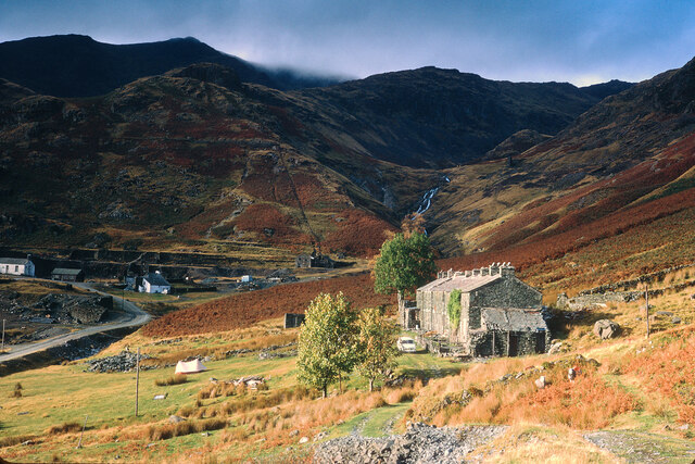
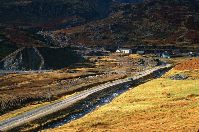
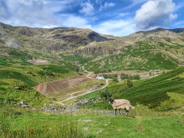
Brackeny Crag is a prominent hill located in the county of Lancashire, England. Situated in the beautiful region of Ribble Valley, it is a popular destination for hikers, nature enthusiasts, and outdoor adventurers. With an elevation of approximately 400 meters (1,312 feet), it offers breathtaking views of the surrounding countryside.

The hill is characterized by its rugged and rocky terrain, with scattered outcrops and crags that give it its distinctive name. These rocky formations, made up of gritstone and shale, provide a challenging yet rewarding climb for those seeking a more adventurous experience. Brackeny Crag is known for its steep slopes, which can be challenging for novice hikers but are a delight for experienced climbers.

The hill is covered in a diverse range of vegetation, including heather, grasses, and patches of woodland. This rich flora attracts a variety of wildlife, including birds, small mammals, and insects. Visitors to Brackeny Crag may encounter species such as red grouse, curlews, and even the occasional deer.

The hill is easily accessible, with several footpaths and trails leading to its summit. These paths offer different levels of difficulty, catering to both leisurely walkers and more experienced hikers. While the ascent can be demanding, the effort is rewarded with panoramic views of the surrounding Lancashire countryside, including the picturesque Ribble Valley and the nearby Forest of Bowland.

Overall, Brackeny Crag is a stunning natural landmark in Lancashire, offering visitors a chance to immerse themselves in the beauty of the British countryside while experiencing a challenging and rewarding outdoor adventure.

If you have any feedback on the listing, please let us know in the comments section below.

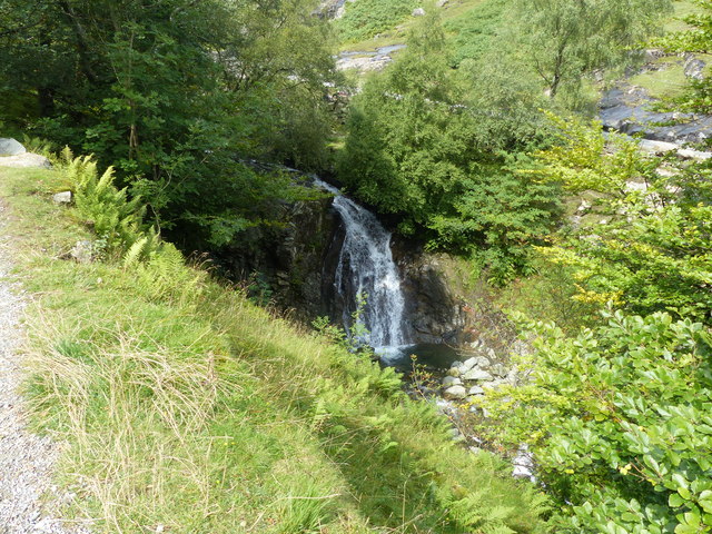
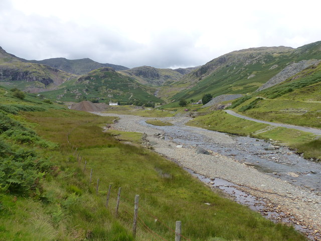
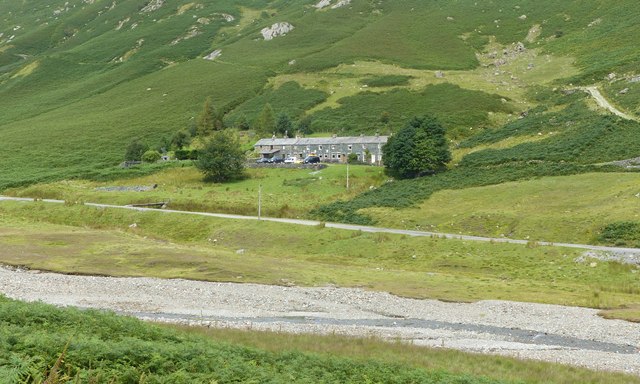
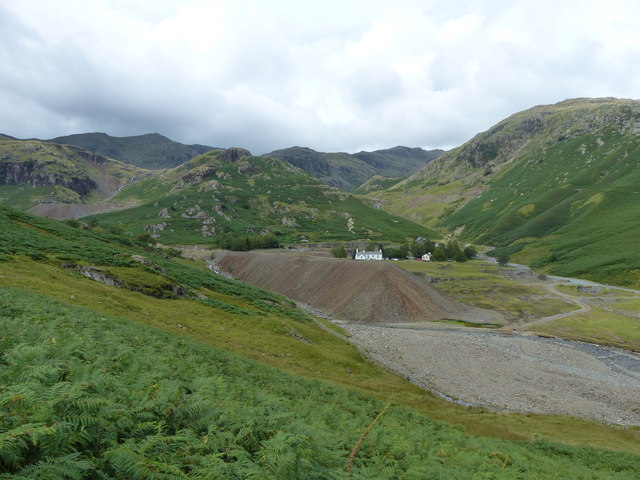
Brackeny Crag Images

Images are sourced within 2km of 54.388855/-3.0748712 or Grid Reference SD3099. Thanks to Geograph Open Source API. All images are credited.

Irish Cottages, Coppermines Valley Irish Cottages in the valley of Church Beck is a terrace of houses above Coniston; two of them together form a climbing hut of the Yorkshire Mountaineering Club. The gravel flats through the centre of the image are where the Church Beck flows and winds.
Irish Cottages, Coppermines Valley
Irish Cottages in the valley of Church Beck is a terrace of houses above Coniston; two of them together form a climbing hut of the Yorkshire Mountaineering Club. The gravel flats through the centre of the image are where the Church Beck flows and winds.
Road heading for Coppermines Valley The valley is actually that of Church Beck but is popularly known as the Coppermines Valley because of the extensive disused mine workings there. The road is private but is used to access accommodation in the valley including houses, a youth hostel and two climbing club huts. The road is also a public footpath.
Coniston Old Man is the mountain seen against the sky.
Road heading for Coppermines Valley
The valley is actually that of Church Beck but is popularly known as the Coppermines Valley because of the extensive disused mine workings there. The road is private but is used to access accommodation in the valley including houses, a youth hostel and two climbing club huts. The road is also a public footpath. Coniston Old Man is the mountain seen against the sky.
Slope with minor rock outcrops The near slope is close to the feature named on OS maps as Flat Bield and is separated from the camera location by a steep stream groove. The valley beyond it is Red Dell.
The sunlit rockface at the centre of the image and beyond Red Dell is Kennel Crag, sometimes known as Kernel Crag.
Slope with minor rock outcrops
The near slope is close to the feature named on OS maps as Flat Bield and is separated from the camera location by a steep stream groove. The valley beyond it is Red Dell. The sunlit rockface at the centre of the image and beyond Red Dell is Kennel Crag, sometimes known as Kernel Crag.
Shallow pool on ridge rising to Wetherlam A broad, lengthy ridge which in its higher reach is fairly featureless rises generally northwards to the Wetherlam summit. There are minor knolls and a tarn or two; this is the more attractive of them.
Helvellyn and Fairfield and their satellite mountains are in the distance.
Shallow pool on ridge rising to Wetherlam
A broad, lengthy ridge which in its higher reach is fairly featureless rises generally northwards to the Wetherlam summit. There are minor knolls and a tarn or two; this is the more attractive of them. Helvellyn and Fairfield and their satellite mountains are in the distance.
Settling tanks at Bonsor upper mill The series of shallow depressions near to the Coppermines Youth Hostel is named as 'tanks' in the 1969 volume, 'Industrial Archaeology of the Lake Counties' - Marshall & Davies-Shiel. It's supposed that they were settling tanks in which small particles of rock etc. would be allowed to fall to the bottom before the then clearer water would be allowed to flow down to Coniston in the valley below.
Settling tanks at Bonsor upper mill
The series of shallow depressions near to the Coppermines Youth Hostel is named as 'tanks' in the 1969 volume, 'Industrial Archaeology of the Lake Counties' - Marshall & Davies-Shiel. It's supposed that they were settling tanks in which small particles of rock etc. would be allowed to fall to the bottom before the then clearer water would be allowed to flow down to Coniston in the valley below.
Coppermines Cottage In the past, when copper was being mined, the cottage was occupied by a mine official, presumably the site manager. In 1958 it was acquired by the Barrow Mountaineering and Ski Club which still uses it as a club hut.
Coppermines Cottage
In the past, when copper was being mined, the cottage was occupied by a mine official, presumably the site manager. In 1958 it was acquired by the Barrow Mountaineering and Ski Club which still uses it as a club hut.
Irish Cottages, Coppermine Valley In 2022, the foreground buildings, Irish Cottages,  were the property of the Yorkshire Mountaineering Club. I am unsure of their status in January 1973 when this image was taken. Mine workings can be seen in the background.
Irish Cottages, Coppermine Valley
In 2022, the foreground buildings, Irish Cottages, were the property of the Yorkshire Mountaineering Club. I am unsure of their status in January 1973 when this image was taken. Mine workings can be seen in the background.
The head of Coppermine Valley, Coniston In January 1973 the white building was the Youth Hostel.  A track continues beyond here into the Coniston Fells.
The head of Coppermine Valley, Coniston
In January 1973 the white building was the Youth Hostel. A track continues beyond here into the Coniston Fells.
The Air Ambulance on Wetherlam The Coniston Mountain Rescue Team (MRT) were training at base when the call came for a fell-runner who had slipped on descent, injured his ankle, and could no longer stand. The team attended and carried him down below the cloud. Fortunately a helicopter was available to transport the casualty to Furness General Hospital.
The Air Ambulance on Wetherlam
The Coniston Mountain Rescue Team (MRT) were training at base when the call came for a fell-runner who had slipped on descent, injured his ankle, and could no longer stand. The team attended and carried him down below the cloud. Fortunately a helicopter was available to transport the casualty to Furness General Hospital.
The Wheel of Misfortune The Thriddle Incline from the New Engine House Shaft waterwheel pit - The Wheel of Misfortune
The Wheel of Misfortune
The Thriddle Incline from the New Engine House Shaft waterwheel pit - The Wheel of Misfortune
Waterfall on Church Beck
Coppermines Valley, Coniston
Irish Row, Coppermines Valley
Coppermines Valley, Coniston
Coppermines Valley
Coppermines Valley
Coppermines Youth Hostel Looking across Levers Water Beck towards Coppermines Youth Hostel.
Coppermines Youth Hostel
Looking across Levers Water Beck towards Coppermines Youth Hostel.
Coppermines Cottages Coppermines Cottages seen across Levers Water Beck.
Coppermines Cottages
Coppermines Cottages seen across Levers Water Beck.
Coppermines Cottages Coppermines Cottages (on the left of the photo) seen across Levers Water Beck.
Coppermines Cottages
Coppermines Cottages (on the left of the photo) seen across Levers Water Beck.
Show me another place!

Brackeny Crag is located at Grid Ref: SD3099 (Lat: 54.388855, Lng: -3.0748712)

Administrative County: Cumbria

District: South Lakeland

Police Authority: Cumbria

What 3 Words

///recruiter.aviation.towels. Near Ambleside, Cumbria

Related Wikis

Holme Fell

Holme Fell or Holm Fell is a fell in the Lake District in Cumbria, England. It is located between Coniston Water and Little Langdale, almost isolated from...

Coniston copper mines

The Coniston copper mines were a copper mining operation in Lancashire, England. It was functional for hundreds of years in Coppermines Valley above Coniston...

Yew Tree Tarn

Yew Tree Tarn is a small lake in the English Lake District situated in between the towns of Ambleside and Coniston. The tarn was formed when the local...

Wetherlam

Wetherlam (763 m) is a mountain in the English Lake District. It is the most northerly of the Coniston Fells, the range of fells to the north-west of Coniston...

Ruskin Museum

The Ruskin Museum is a small local museum in Coniston, Cumbria, northern England. It was established in 1901 by W. G. Collingwood, an artist and antiquarian...

Coniston, Cumbria

Coniston is a village and civil parish in the Westmorland and Furness district of Cumbria, England. In the 2001 census the parish had a population of 1...

Coniston railway station (England)

Coniston railway station was the northern terminus of the Coniston branch line in the village of Coniston, Lancashire, England (now in Cumbria). ��2�...

John Ruskin School

John Ruskin School (JRS) is an 11–16 school on Lake Road in Coniston, Cumbria. The school is part of the Rural Academy, a group of nine small schools in...

Nearby Amenities

Located within 500m of 54.388855,-3.0748712
Low Wythow
Place: locality
Lat/Long: 54.3847233/-3.0741392
White Gill Moss
Place: locality
Lat/Long: 54.3878857/-3.0727258
Brackeny Crag
Place: locality
Lat/Long: 54.3882229/-3.0753036
The data included in this document is from www.openstreetmap.org. The data is made available under ODbL.

Have you been to Brackeny Crag?

Leave your review of Brackeny Crag below (or comments, questions and feedback).