Horton Bank

Settlement in Yorkshire

England

Horton Bank

Buttershaw St Paul's Cricket Ground - St Paul's Avenue
Buttershaw St Paul's Cricket Ground - St Paul's Avenue Credit: Betty Longbottom

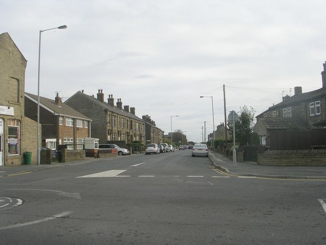
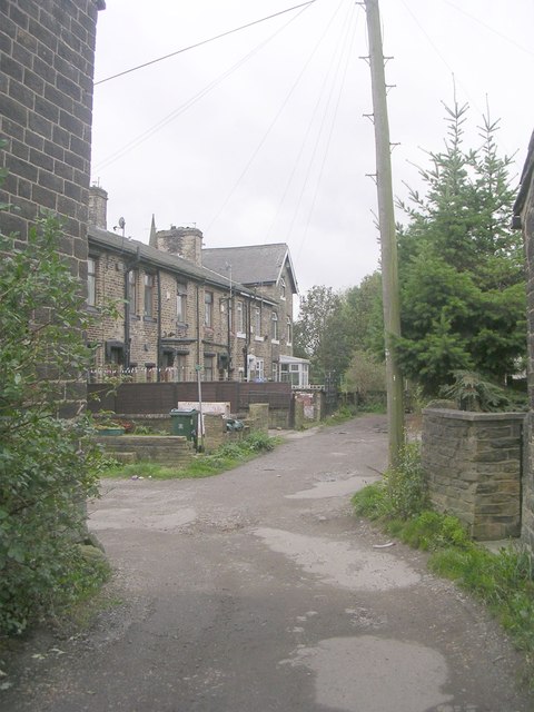
Horton Bank is a small village located in the county of Yorkshire, England. Situated in the district of Bradford, it lies approximately 3 miles west of the city center. The village is nestled amidst picturesque countryside and is surrounded by rolling hills and green fields, providing a serene and peaceful environment.

Horton Bank is known for its close-knit community and friendly atmosphere. The village has a population of around 1,000 residents who enjoy a high quality of life. The area is mainly residential, with a mix of traditional stone-built houses and more modern properties. The architecture reflects the village's long history, with some buildings dating back several centuries.

Amenities in Horton Bank are limited but sufficient to meet the needs of the local community. The village is home to a small convenience store, a post office, and a primary school, ensuring that residents have access to essential services within walking distance. For more extensive shopping and entertainment options, residents can easily access the nearby city of Bradford.

The surrounding countryside offers ample opportunities for outdoor activities such as hiking, cycling, and nature walks. Horton Bank is also well-connected to public transportation, with regular bus services connecting the village to Bradford and other nearby towns.

In conclusion, Horton Bank is a charming village in Yorkshire that provides a tranquil living environment while still offering easy access to urban amenities. Its strong community spirit and beautiful surroundings make it an attractive place to call home.

If you have any feedback on the listing, please let us know in the comments section below.

Horton Bank Images

Images are sourced within 2km of 53.775617/-1.800428 or Grid Reference SE1331. Thanks to Geograph Open Source API. All images are credited.

Buttershaw St Paul's Cricket Ground - St Paul's Avenue
Slack Bottom Road - Buttershaw Lane
Buttershaw Lane - viewed from Slack Bottom Road
Buttershaw Lane Working Men's Club - Buttershaw Lane
Fish & Chip Shop - Buttershaw Lane
Julia's Florist - Buttershaw Lane
Harbour Road - St Helena Road
St Helena Road - viewed from St Paul's Avenue
St Helena Road - viewed from near St Paul's Avenue
Littlefield Walk - St Helena Road
Littlefield Walk - looking towards St Helena Road
Reevy Road - St Helena Road
Corner Stores - Reevy Road
Ormond Road - Tennyson Road
Folly Hall Avenue - Folly Hall Road
Croft House Road - Folly Hall Road
St Paul's Road - Pothouse Road
Show me another place!

Horton Bank is located at Grid Ref: SE1331 (Lat: 53.775617, Lng: -1.800428)

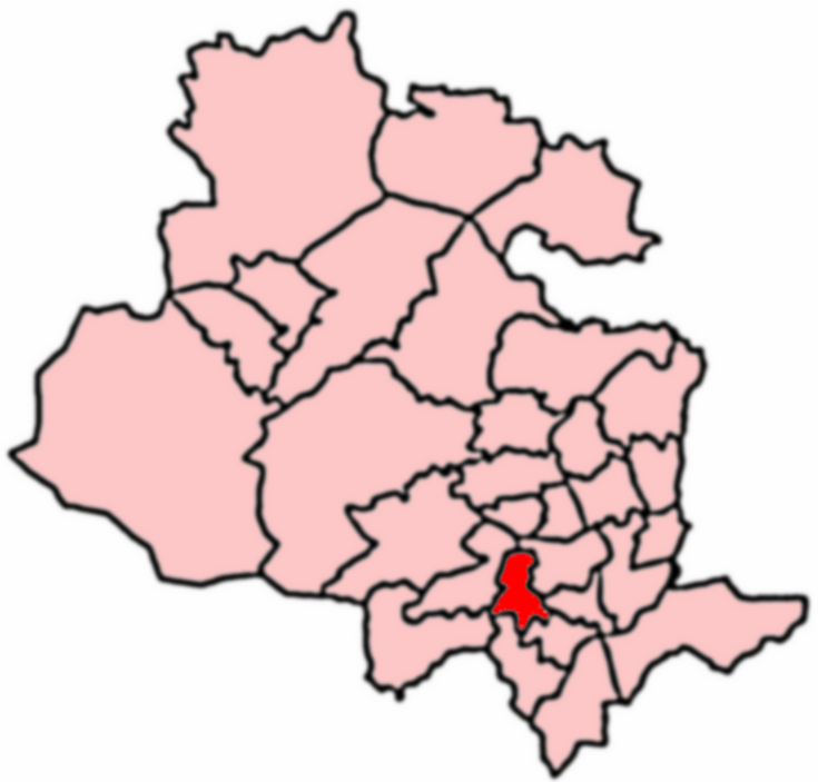
Division: West Riding

Unitary Authority: Bradford

Police Authority: West Yorkshire

What 3 Words

///rally.modest.quick. Near Clayton, West Yorkshire

Related Wikis

Great Horton

Great Horton is a ward of the City of Bradford, West Yorkshire, England, with a population of 17,683 at the 2011 Census. Great Horton is west of Bradford...

Thornton View Hospital

Thornton View hospital was an 82-bed geriatric hospital near Clayton, West Yorkshire, on the site of the North Bierley Union workhouse. == History == The...

Clayton, West Yorkshire

Clayton, or Clayton Village, is a civil parish in the City of Bradford metropolitan borough in West Yorkshire, England, situated 3 miles (4.8 km) to the...

Clayton railway station (England)

Clayton railway station was on the Great Northern Railway lines to Bradford, Keighley and Halifax via Queensbury, collectively known as the Queensbury...

Nearby Amenities

Located within 500m of 53.775617,-1.800428
Horton Bank
Place: locality
Lat/Long: 53.7748552/-1.7991763
Bus Stop
Great Horton Road Old Road
Local Ref: 45015348
Naptan AtcoCode: 450015348
Naptan Bearing: W
Naptan CommonName: Great Horton Road Old Road
Naptan Crossing: Old Road
Naptan Indicator: Stop 45015348
Naptan PlusbusZoneRef: LEEDS
Naptan ShortCommonName: Old Road
Naptan Street: Great Horton Road
Naptan Verified: no
Source: naptan_import
Lat/Long: 53.7742278/-1.805307
Bus Stop
Great Horton Road Old Road
Local Ref: 45015349
Naptan AtcoCode: 450015349
Naptan Bearing: E
Naptan CommonName: Great Horton Road Old Road
Naptan Crossing: Old Road
Naptan Indicator: Stop 45015349
Naptan Landmark: Bank Top Fisheries
Naptan Notes: OSR taken place 180805
Naptan PlusbusZoneRef: LEEDS
Naptan ShortCommonName: Old Road
Naptan Street: Great Horton Road
Naptan Verified: no
Source: naptan_import
Lat/Long: 53.7743983/-1.8051697
Bus Stop
Great Horton Road Hollingwood Lane
Local Ref: 45015350
Naptan AtcoCode: 450015350
Naptan Bearing: NE
Naptan CommonName: Great Horton Road Hollingwood Lane
Naptan Crossing: Hollingwood Lane
Naptan Indicator: Stop 45015350
Naptan Landmark: Crown PH
Naptan Notes: New TF shelter installed
Naptan PlusbusZoneRef: LEEDS
Naptan ShortCommonName: Hollingwood Lane
Naptan Street: Great Horton Road
Naptan Verified: no
Source: naptan_import
Lat/Long: 53.7747106/-1.8041576
Bus Stop
Great Horton Road Windermere Terrace
Local Ref: 45015351
Naptan AtcoCode: 450015351
Naptan Bearing: W
Naptan CommonName: Great Horton Road Windermere Terrace
Naptan Crossing: Windermere Terrace
Naptan Indicator: Stop 45015351
Naptan Landmark: Horton Bank Church
Naptan PlusbusZoneRef: LEEDS
Naptan ShortCommonName: Windermere Terrace
Naptan Street: Great Horton Road
Naptan Verified: no
Source: naptan_import
Lat/Long: 53.7752956/-1.7988076
Bus Stop
Great Horton Road Windermere Terrace
Local Ref: 45015352
Naptan AtcoCode: 450015352
Naptan Bearing: E
Naptan CommonName: Great Horton Road Windermere Terrace
Naptan Crossing: Windermere Terrace
Naptan Indicator: Stop 45015352
Naptan Landmark: Horton Bank Methodist Church
Naptan Notes: OSR taken place 180805
Naptan PlusbusZoneRef: LEEDS
Naptan ShortCommonName: Windermere Terrace
Naptan Street: Great Horton Road
Naptan Verified: no
Source: naptan_import
Lat/Long: 53.7753856/-1.7988375
Bus Stop
Great Horton Road Windermere Road
Local Ref: 45015353
Naptan AtcoCode: 450015353
Naptan Bearing: W
Naptan CommonName: Great Horton Road Windermere Road
Naptan Indicator: Stop 45015353
Naptan Notes: OSR taken place 140905
Naptan PlusbusZoneRef: LEEDS
Naptan ShortCommonName: Great Horton Road
Naptan Street: Great Horton Road
Naptan Verified: no
Source: naptan_import
Lat/Long: 53.7753723/-1.7963187
Bus Stop
Great Horton Road Windermere Road
Local Ref: 45015354
Naptan AtcoCode: 450015354
Naptan Bearing: E
Naptan CommonName: Great Horton Road Windermere Road
Naptan Indicator: Stop 45015354
Naptan PlusbusZoneRef: LEEDS
Naptan ShortCommonName: Great Horton Road
Naptan Street: Great Horton Road
Naptan Verified: no
Source: naptan_import
Lat/Long: 53.7755424/-1.7959233
Bus Stop
Great Horton Road Moore Avenue
Local Ref: 45015355
Naptan AtcoCode: 450015355
Naptan Bearing: SW
Naptan CommonName: Great Horton Road Moore Avenue
Naptan Crossing: Moore Avenue
Naptan Indicator: Stop 45015355
Naptan Landmark: White Horse PH
Naptan PlusbusZoneRef: LEEDS
Naptan ShortCommonName: Moore Avenue
Naptan Street: Great Horton Road
Naptan Verified: no
Source: naptan_import
Lat/Long: 53.7761307/-1.793007
Bus Stop
Hollingwood Lane Frensham Drive
Local Ref: 45022530
Naptan AtcoCode: 450022530
Naptan Bearing: N
Naptan CommonName: Hollingwood Lane Frensham Drive
Naptan Crossing: Frensham Drive
Naptan Indicator: Stop 45022530
Naptan Notes: OSR taken place 180805
Naptan PlusbusZoneRef: LEEDS
Naptan ShortCommonName: Frensham Drive
Naptan Street: Hollingwood Lane
Naptan Verified: no
Source: naptan_import
Lat/Long: 53.7752258/-1.8036338
Bus Stop
Hollingwood Lane Mickledore Ridge
Local Ref: 45022531
Naptan AtcoCode: 450022531
Naptan Bearing: SW
Naptan CommonName: Hollingwood Lane Mickledore Ridge
Naptan Crossing: Mickledore Ridge
Naptan Indicator: Stop 45022531
Naptan PlusbusZoneRef: LEEDS
Naptan ShortCommonName: Micheldore Ridge
Naptan Street: Hollingwood Lane
Naptan Verified: no
Source: naptan_import
Lat/Long: 53.7757472/-1.8031038
Bus Stop
Hollingwood Lane Highlands Grove
Local Ref: 45022532
Naptan AtcoCode: 450022532
Naptan Bearing: NE
Naptan CommonName: Hollingwood Lane Highlands Grove
Naptan Crossing: Highlands Grove
Naptan Indicator: Stop 45022532
Naptan PlusbusZoneRef: LEEDS
Naptan ShortCommonName: Highlands Grove
Naptan Street: Hollingwood Lane
Naptan Verified: no
Source: naptan_import
Lat/Long: 53.7783363/-1.8004715
Bus Stop
Hollingwood Lane Highlands Grove
Local Ref: 45022533
Naptan AtcoCode: 450022533
Naptan Bearing: SW
Naptan CommonName: Hollingwood Lane Highlands Grove
Naptan Crossing: Highlands Grove
Naptan Indicator: Stop 45022533
Naptan PlusbusZoneRef: LEEDS
Naptan ShortCommonName: Highlands Grove
Naptan Street: Hollingwood Lane
Naptan Verified: no
Source: naptan_import
Lat/Long: 53.7784537/-1.8007197
Bus Stop
Hollybank Road Hollingwood Lane
Local Ref: 45022534
Naptan AtcoCode: 450022534
Naptan Bearing: NW
Naptan CommonName: Hollybank Road Hollingwood Lane
Naptan Crossing: Hollingwood Lane
Naptan Indicator: Stop 45022534
Naptan Notes: OSR taken place 160905
Naptan PlusbusZoneRef: LEEDS
Naptan ShortCommonName: Hollingwood Lane
Naptan Street: Hollybank Road
Naptan Verified: no
Source: naptan_import
Lat/Long: 53.7796281/-1.7988931
Bus Stop
Hollybank Road Hollingwood Lane
Local Ref: 45022535
Naptan AtcoCode: 450022535
Naptan Bearing: SE
Naptan CommonName: Hollybank Road Hollingwood Lane
Naptan Crossing: Hollingwood Lane
Naptan Indicator: Stop 45022535
Naptan Notes: OSR taken place 180805
Naptan PlusbusZoneRef: LEEDS
Naptan ShortCommonName: Hollingwood Lane
Naptan Street: Hollybank Road
Naptan Verified: no
Source: naptan_import
Lat/Long: 53.7794748/-1.7985903
Bus Stop
Hollybank Road Hollybank Grove
Local Ref: 45022536
Naptan AtcoCode: 450022536
Naptan Bearing: NW
Naptan CommonName: Hollybank Road Hollybank Grove
Naptan Crossing: Hollybank Grove
Naptan Indicator: Stop 45022536
Naptan Notes: OSR taken place 160905
Naptan PlusbusZoneRef: LEEDS
Naptan ShortCommonName: Hollybank Grove
Naptan Street: Hollybank Road
Naptan Verified: no
Source: naptan_import
Lat/Long: 53.778584/-1.7980027
Bus Stop
Hollybank Road Brackenhill Drive
Local Ref: 45022537
Naptan AtcoCode: 450022537
Naptan Bearing: SE
Naptan CommonName: Hollybank Road Brackenhill Drive
Naptan Crossing: Brackenhill Drive
Naptan Indicator: Stop 45022537
Naptan Notes: OSR taken place 180805
Naptan PlusbusZoneRef: LEEDS
Naptan ShortCommonName: Brackenhill Drive
Naptan Street: Hollybank Road
Naptan Verified: no
Source: naptan_import
Lat/Long: 53.7783216/-1.7969873
Bus Stop
Bartle Lane Hollybank Road
Local Ref: 45023924
Naptan AtcoCode: 450023924
Naptan Bearing: SW
Naptan CommonName: Bartle Lane Hollybank Road
Naptan Crossing: Hollybank Road
Naptan Indicator: Stop 45023924
Naptan Notes: OSR taken place 140905
Naptan PlusbusZoneRef: LEEDS
Naptan ShortCommonName: Hollybank Road
Naptan Street: Bartle Lane
Naptan Verified: no
Source: naptan_import
Lat/Long: 53.7779259/-1.7947413
Bus Stop
Bartle Lane Bevan Court
Local Ref: 45023974
Naptan AtcoCode: 450023974
Naptan Bearing: NE
Naptan CommonName: Bartle Lane Bevan Court
Naptan Crossing: Bevan Court
Naptan Indicator: Stop 45023974
Naptan Notes: OSR taken place 180805L/C 9
Naptan PlusbusZoneRef: LEEDS
Naptan ShortCommonName: Bevan Court
Naptan Street: Bartle Lane
Naptan Verified: no
Source: naptan_import
Lat/Long: 53.7782809/-1.7945697
Bus Stop
Poplar Grove Lawrence Drive
Local Ref: 45024227
Naptan AtcoCode: 450024227
Naptan Bearing: SE
Naptan CommonName: Poplar Grove Lawrence Drive
Naptan Crossing: Lawrence Drive
Naptan Indicator: Stop 45024227
Naptan Notes: OSR taken place 180805
Naptan PlusbusZoneRef: LEEDS
Naptan ShortCommonName: Lawrence Drive
Naptan Street: Poplar Grove
Naptan Verified: no
Source: naptan_import
Lat/Long: 53.774162/-1.798115
Bus Stop
Old Road Beacon Street
Local Ref: 45024228
Naptan AtcoCode: 450024228
Naptan Bearing: W
Naptan CommonName: Old Road Beacon Street
Naptan Crossing: Beacon Street
Naptan Indicator: Stop 45024228
Naptan Notes: OSR taken place 180805L/C 7
Naptan PlusbusZoneRef: LEEDS
Naptan ShortCommonName: Beacon Street
Naptan Street: Old Road
Naptan Verified: no
Source: naptan_import
Lat/Long: 53.7744455/-1.8010574
Bus Stop
Speeton Avenue Old Road
Local Ref: 45024230
Naptan AtcoCode: 450024230
Naptan Bearing: N
Naptan CommonName: Speeton Avenue Old Road
Naptan Crossing: Old Road
Naptan Indicator: Stop 45024230
Naptan Landmark: The Crown PH
Naptan Notes: OSR taken place 180805 size 1 case fitted
Naptan PlusbusZoneRef: LEEDS
Naptan ShortCommonName: Speeton Avenue
Naptan Street: Speeton Avenue
Naptan Verified: no
Source: naptan_import
Lat/Long: 53.7743067/-1.8041231
Bus Stop
Poplar Grove Nursery Road
Local Ref: 45024259
Naptan AtcoCode: 450024259
Naptan Bearing: W
Naptan CommonName: Poplar Grove Nursery Road
Naptan Crossing: Nursery Road
Naptan Indicator: Stop 45024259
Naptan Notes: OSR taken place 190805
Naptan PlusbusZoneRef: LEEDS
Naptan ShortCommonName: Nursery Road
Naptan Street: Poplar Grove
Naptan Verified: no
Source: naptan_import
Lat/Long: 53.7734198/-1.7950991
Bus Stop
Great Horton Road Hollingwood Lane
Local Ref: 45025855
Naptan AtcoCode: 450025855
Naptan Bearing: W
Naptan CommonName: Great Horton Road Hollingwood Lane
Naptan Crossing: Nr-Opp Hollingwood Lane
Naptan Indicator: Stop 45025855
Naptan Landmark: School
Naptan Notes: OSR taken place 180805
Naptan PlusbusZoneRef: LEEDS
Naptan ShortCommonName: Hollingwood Lane
Naptan Street: Great Horton Road
Naptan Verified: no
Source: naptan_import
Lat/Long: 53.7751477/-1.801752
Poplar Grove Lawerence Drive
Local Ref: 45051410
Naptan AtcoCode: 450051410
Naptan Bearing: NW
Naptan BusStopType: CUS
Naptan CommonName: Poplar Grove Lawerence Drive
Naptan Indicator: Stop 45051410
Naptan PlusbusZoneRef: LEEDS
Naptan ShortCommonName: Old Road
Naptan Street: Poplar Grove
Naptan Verified: no
Source: naptan_import
Lat/Long: 53.7741171/-1.7981911
Old Road Ascot Avenue
Local Ref: 45051411
Naptan AtcoCode: 450051411
Naptan Bearing: E
Naptan BusStopType: CUS
Naptan CommonName: Old Road Ascot Avenue
Naptan Indicator: Stop 45051411
Naptan PlusbusZoneRef: LEEDS
Naptan ShortCommonName: Ascot Avenue
Naptan Street: Old Road
Naptan Verified: no
Source: naptan_import
Lat/Long: 53.7745264/-1.8010418
Horton Bank Top Speeton Avenue
Local Ref: 45051413
Naptan AtcoCode: 450051413
Naptan Bearing: S
Naptan BusStopType: CUS
Naptan CommonName: Horton Bank Top Speeton Avenue
Naptan Indicator: Stop 45051413
Naptan PlusbusZoneRef: LEEDS
Naptan ShortCommonName: Speeton Avenue
Naptan Street: Speeton Avenue
Naptan Verified: no
Source: naptan_import
Lat/Long: 53.7743064/-1.803941
Poplar Grove Nursery Road
Local Ref: 45051419
Naptan AtcoCode: 450051419
Naptan Bearing: E
Naptan BusStopType: CUS
Naptan CommonName: Poplar Grove Nursery Road
Naptan Indicator: Stop 45051419
Naptan PlusbusZoneRef: LEEDS
Naptan ShortCommonName: Nursery Road
Naptan Street: Poplar Grove
Naptan Verified: no
Source: naptan_import
Lat/Long: 53.7734917/-1.7951139
Pub
The Monkey
Addr City: Bradford
Addr Housenumber: 931-933
Addr Postcode: BD7 4AQ
Addr Street: Great Horton Road
Fhrs Id: 325102
Source Addr: FHRS Open Data
Lat/Long: 53.7750986/-1.8011041
Turning Circle
Lat/Long: 53.7773386/-1.7955813
Ele: 211.2
Lat/Long: 53.7776746/-1.7951929
Pharmacy
Boots
Addr City: Bradford
Addr Housenumber: 1220A
Addr Postcode: BD7 4PL
Addr Street: Great Horton Road
Brand Wikidata: Q6123139
Fhrs Id: 325683
Source Addr: FHRS Open Data
Lat/Long: 53.7740261/-1.8073103
Pub
The Crown
Addr City: Bradford
Addr Housenumber: 1033
Addr Postcode: BD7 4AH
Addr Street: Great Horton Road
Brand: Greene King
Brand Wikidata: Q5564162
Fhrs Id: 325058
Source Addr: FHRS Open Data
Website: https://www.greeneking.co.uk/pubs/west-yorkshire/crown
Lat/Long: 53.7745468/-1.804114
Ele: 261.1
Lat/Long: 53.7759625/-1.8055138
Ele: 253.8
Lat/Long: 53.77629/-1.8067031
Ele: 248.7
Lat/Long: 53.7774015/-1.8035446
Ele: 260.6
Lat/Long: 53.775923/-1.8057882
Ele: 255.8
Lat/Long: 53.7759697/-1.8075469
Ele: 248.7
Lat/Long: 53.7774701/-1.803539
Ele: 248.4
Lat/Long: 53.7771778/-1.8026493
Ele: 237.8
Lat/Long: 53.7790577/-1.8041079
Ele: 234.2
Lat/Long: 53.7780538/-1.8013605
Mini Roundabout
Lat/Long: 53.7743711/-1.7984379
B R News
Addr City: Bradford
Addr Housenumber: 204
Addr Postcode: BD7 4BJ
Addr Street: Hollingwood Lane
Fhrs Id: 325588
Shop: convenience
Lat/Long: 53.7793528/-1.8002416
Entrance: main
Lat/Long: 53.7776344/-1.803095
Slack Side
Place: suburb
Lat/Long: 53.7718907/-1.7988164
The data included in this document is from www.openstreetmap.org. The data is made available under ODbL.

Have you been to Horton Bank?

Leave your review of Horton Bank below (or comments, questions and feedback).