Highwood
Settlement in Dorset
England
Highwood
![Wool houses [21] Rowan Tree Cottage, number 60 Church Lane, was formerly two cottages. Built, probably, in the 18th century of plastered cob walls on a stone base under a thatch roof. The former attached barn, under a tile roof, is now part of the cottage. There is a rear extension. Some original internal features remain. Listed, grade II, with details at: <span class="nowrap"><a title="https://historicengland.org.uk/listing/the-list/list-entry/1152867" rel="nofollow ugc noopener" href="https://historicengland.org.uk/listing/the-list/list-entry/1152867">Link</a><img style="margin-left:2px;" alt="External link" title="External link - shift click to open in new window" src="https://s1.geograph.org.uk/img/external.png" width="10" height="10"/></span>
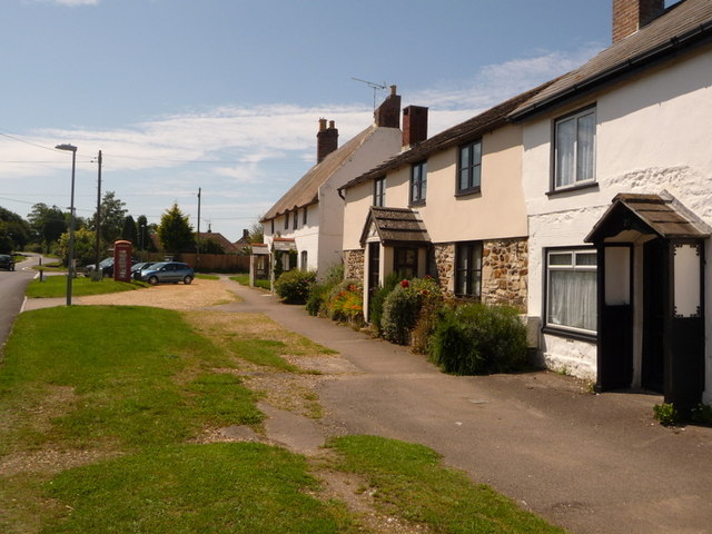
Wool is a large village in Dorset, midway between Dorchester and Poole, both about 10 miles distant. Set on the south bank of the River Frome, the village includes Bovington Camp army base to the north. The place-name &#039;Wool&#039; is first recorded in Anglo-Saxon Writs in the first years of the 11th century. The ruins of Bindon Abbey are nearby, demolished in 1539, the stone was used to build castles in Portland, Lulworth and Sandsfoot.](https://s3.geograph.org.uk/geophotos/07/25/88/7258859_a2c36b9e.jpg)
Highwood is a small village located in the county of Dorset, England. Situated in the southwestern part of the country, it is nestled amidst the beautiful countryside and picturesque landscapes that the region is renowned for. With a population of around 500 residents, Highwood exudes a peaceful and tight-knit community atmosphere.
The village itself boasts a charming mix of architectural styles, with several historic buildings that add character to the area. The local church, St. Mary's, is a notable landmark dating back to the 12th century, showcasing stunning medieval architecture. Additionally, there are a handful of quaint cottages and traditional houses that dot the village streets, providing a glimpse into the area's rich heritage.
Surrounded by rolling hills and verdant fields, Highwood offers ample opportunities for outdoor activities and exploration. Nature enthusiasts can enjoy meandering walking trails that wind through the countryside, providing panoramic views of the surrounding area. The village is also home to a community park, where locals gather for recreational activities and events.
While Highwood primarily serves as a residential area, it is conveniently located near several amenities. The nearby market town of Dorchester provides residents with access to a range of shops, restaurants, and services. Additionally, the village benefits from excellent transport links, with regular bus services connecting it to neighboring towns and villages.
Overall, Highwood is a tranquil and picturesque village that offers a peaceful retreat from the hustle and bustle of city life. With its rich history, natural beauty, and close-knit community, Highwood is a hidden gem in the heart of Dorset.
If you have any feedback on the listing, please let us know in the comments section below.
Highwood Images
Images are sourced within 2km of 50.6645/-2.1994482 or Grid Reference SY8685. Thanks to Geograph Open Source API. All images are credited.
![Wool houses [22] Kingfisher Cottage, number 61 Church Lane, was probably built in the 18th century. Constructed of pebbledashed cob under a thatch roof. There is a later rear extension. Listed, grade II, with details at: <span class="nowrap"><a title="https://historicengland.org.uk/listing/the-list/list-entry/1120363" rel="nofollow ugc noopener" href="https://historicengland.org.uk/listing/the-list/list-entry/1120363">Link</a><img style="margin-left:2px;" alt="External link" title="External link - shift click to open in new window" src="https://s1.geograph.org.uk/img/external.png" width="10" height="10"/></span>
Wool is a large village in Dorset, midway between Dorchester and Poole, both about 10 miles distant. Set on the south bank of the River Frome, the village includes Bovington Camp army base to the north. The place-name &#039;Wool&#039; is first recorded in Anglo-Saxon Writs in the first years of the 11th century. The ruins of Bindon Abbey are nearby, demolished in 1539, the stone was used to build castles in Portland, Lulworth and Sandsfoot.](https://s3.geograph.org.uk/geophotos/07/25/88/7258863_3ec885ee.jpg)
![Wool houses [23] Melissa Cottage, number 62 Church Lane, was built in the 18th century, altered in the 19th century and extended in the late 20th century. Constructed of plastered cob on a stone base under a tile roof. Most of the windows are
horizontally sliding sashes. Listed, for group value, grade II, with details at: <span class="nowrap"><a title="https://historicengland.org.uk/listing/the-list/list-entry/1323394" rel="nofollow ugc noopener" href="https://historicengland.org.uk/listing/the-list/list-entry/1323394">Link</a><img style="margin-left:2px;" alt="External link" title="External link - shift click to open in new window" src="https://s1.geograph.org.uk/img/external.png" width="10" height="10"/></span>
Wool is a large village in Dorset, midway between Dorchester and Poole, both about 10 miles distant. Set on the south bank of the River Frome, the village includes Bovington Camp army base to the north. The place-name &#039;Wool&#039; is first recorded in Anglo-Saxon Writs in the first years of the 11th century. The ruins of Bindon Abbey are nearby, demolished in 1539, the stone was used to build castles in Portland, Lulworth and Sandsfoot.](https://s1.geograph.org.uk/geophotos/07/25/88/7258865_bea37e67.jpg)
![Wool houses [24] The Thatched Cottage, number 64 Church Lane, was probably built in the 18th century, possibly incorporating an earlier structure. Constructed partly of plastered cob, partly of brick, on a stone base, all under a thatch roof. Many of the windows are horizontally sliding sashes. Listed, grade II, with details at: <span class="nowrap"><a title="https://historicengland.org.uk/listing/the-list/list-entry/1323393" rel="nofollow ugc noopener" href="https://historicengland.org.uk/listing/the-list/list-entry/1323393">Link</a><img style="margin-left:2px;" alt="External link" title="External link - shift click to open in new window" src="https://s1.geograph.org.uk/img/external.png" width="10" height="10"/></span>
Wool is a large village in Dorset, midway between Dorchester and Poole, both about 10 miles distant. Set on the south bank of the River Frome, the village includes Bovington Camp army base to the north. The place-name &#039;Wool&#039; is first recorded in Anglo-Saxon Writs in the first years of the 11th century. The ruins of Bindon Abbey are nearby, demolished in 1539, the stone was used to build castles in Portland, Lulworth and Sandsfoot.](https://s1.geograph.org.uk/geophotos/07/25/89/7258905_89f5f701.jpg)
![Parish church [1] The Anglican parish church of The Holy Rood was built, nave only, in the 13th century, the chancel, north arcade and tower were added circa 1450. In 1865 the church was demolished except for the tower and north and east walls of the nave, and rebuilt. Constructed of rubble stone with free stone dressings under roofs of tile or of lead. The font is 15th century, other internal fittings are 19th century. Listed, grade II*, with details at: <span class="nowrap"><a title="https://historicengland.org.uk/listing/the-list/list-entry/1120365" rel="nofollow ugc noopener" href="https://historicengland.org.uk/listing/the-list/list-entry/1120365">Link</a><img style="margin-left:2px;" alt="External link" title="External link - shift click to open in new window" src="https://s1.geograph.org.uk/img/external.png" width="10" height="10"/></span>
Wool is a large village in Dorset, midway between Dorchester and Poole, both about 10 miles distant. Set on the south bank of the River Frome, the village includes Bovington Camp army base to the north. The place-name &#039;Wool&#039; is first recorded in Anglo-Saxon Writs in the first years of the 11th century. The ruins of Bindon Abbey are nearby, demolished in 1539, the stone was used to build castles in Portland, Lulworth and Sandsfoot.](https://s1.geograph.org.uk/geophotos/07/25/89/7258909_5d802de1.jpg)
![Parish church [2] The Anglican parish church of The Holy Rood was built, nave only, in the 13th century, the chancel, north arcade and tower were added circa 1450. In 1865 the church was demolished except for the tower and north and east walls of the nave, and rebuilt. Constructed of rubble stone with free stone dressings under roofs of tile or of lead. The font is 15th century, other internal fittings are 19th century. Listed, grade II*, with details at: <span class="nowrap"><a title="https://historicengland.org.uk/listing/the-list/list-entry/1120365" rel="nofollow ugc noopener" href="https://historicengland.org.uk/listing/the-list/list-entry/1120365">Link</a><img style="margin-left:2px;" alt="External link" title="External link - shift click to open in new window" src="https://s1.geograph.org.uk/img/external.png" width="10" height="10"/></span>
Wool is a large village in Dorset, midway between Dorchester and Poole, both about 10 miles distant. Set on the south bank of the River Frome, the village includes Bovington Camp army base to the north. The place-name &#039;Wool&#039; is first recorded in Anglo-Saxon Writs in the first years of the 11th century. The ruins of Bindon Abbey are nearby, demolished in 1539, the stone was used to build castles in Portland, Lulworth and Sandsfoot.](https://s2.geograph.org.uk/geophotos/07/25/89/7258910_36eaadd8.jpg)
![Parish church [3] The chancel.
The Anglican parish church of The Holy Rood was built, nave only, in the 13th century, the chancel, north arcade and tower were added circa 1450. In 1865 the church was demolished except for the tower and north and east walls of the nave, and rebuilt. Constructed of rubble stone with free stone dressings under roofs of tile or of lead. The font is 15th century, other internal fittings are 19th century. Listed, grade II*, with details at: <span class="nowrap"><a title="https://historicengland.org.uk/listing/the-list/list-entry/1120365" rel="nofollow ugc noopener" href="https://historicengland.org.uk/listing/the-list/list-entry/1120365">Link</a><img style="margin-left:2px;" alt="External link" title="External link - shift click to open in new window" src="https://s1.geograph.org.uk/img/external.png" width="10" height="10"/></span>
Wool is a large village in Dorset, midway between Dorchester and Poole, both about 10 miles distant. Set on the south bank of the River Frome, the village includes Bovington Camp army base to the north. The place-name &#039;Wool&#039; is first recorded in Anglo-Saxon Writs in the first years of the 11th century. The ruins of Bindon Abbey are nearby, demolished in 1539, the stone was used to build castles in Portland, Lulworth and Sandsfoot.](https://s3.geograph.org.uk/geophotos/07/25/89/7258911_cb7e2a3d.jpg)
![Parish church [4] The east window.
The Anglican parish church of The Holy Rood was built, nave only, in the 13th century, the chancel, north arcade and tower were added circa 1450. In 1865 the church was demolished except for the tower and north and east walls of the nave, and rebuilt. Constructed of rubble stone with free stone dressings under roofs of tile or of lead. The font is 15th century, other internal fittings are 19th century. Listed, grade II*, with details at: <span class="nowrap"><a title="https://historicengland.org.uk/listing/the-list/list-entry/1120365" rel="nofollow ugc noopener" href="https://historicengland.org.uk/listing/the-list/list-entry/1120365">Link</a><img style="margin-left:2px;" alt="External link" title="External link - shift click to open in new window" src="https://s1.geograph.org.uk/img/external.png" width="10" height="10"/></span>
Wool is a large village in Dorset, midway between Dorchester and Poole, both about 10 miles distant. Set on the south bank of the River Frome, the village includes Bovington Camp army base to the north. The place-name &#039;Wool&#039; is first recorded in Anglo-Saxon Writs in the first years of the 11th century. The ruins of Bindon Abbey are nearby, demolished in 1539, the stone was used to build castles in Portland, Lulworth and Sandsfoot.](https://s0.geograph.org.uk/geophotos/07/25/89/7258912_813e7f7c.jpg)
![Parish church [5] The organ.
The Anglican parish church of The Holy Rood was built, nave only, in the 13th century, the chancel, north arcade and tower were added circa 1450. In 1865 the church was demolished except for the tower and north and east walls of the nave, and rebuilt. Constructed of rubble stone with free stone dressings under roofs of tile or of lead. The font is 15th century, other internal fittings are 19th century. Listed, grade II*, with details at: <span class="nowrap"><a title="https://historicengland.org.uk/listing/the-list/list-entry/1120365" rel="nofollow ugc noopener" href="https://historicengland.org.uk/listing/the-list/list-entry/1120365">Link</a><img style="margin-left:2px;" alt="External link" title="External link - shift click to open in new window" src="https://s1.geograph.org.uk/img/external.png" width="10" height="10"/></span>
Wool is a large village in Dorset, midway between Dorchester and Poole, both about 10 miles distant. Set on the south bank of the River Frome, the village includes Bovington Camp army base to the north. The place-name &#039;Wool&#039; is first recorded in Anglo-Saxon Writs in the first years of the 11th century. The ruins of Bindon Abbey are nearby, demolished in 1539, the stone was used to build castles in Portland, Lulworth and Sandsfoot.](https://s1.geograph.org.uk/geophotos/07/25/89/7258913_eaf612ba.jpg)
![Parish church [6] The 15th century font, unusually built against a pier of the north arcade.
The Anglican parish church of The Holy Rood was built, nave only, in the 13th century, the chancel, north arcade and tower were added circa 1450. In 1865 the church was demolished except for the tower and north and east walls of the nave, and rebuilt. Constructed of rubble stone with free stone dressings under roofs of tile or of lead. The font is 15th century, other internal fittings are 19th century. Listed, grade II*, with details at: <span class="nowrap"><a title="https://historicengland.org.uk/listing/the-list/list-entry/1120365" rel="nofollow ugc noopener" href="https://historicengland.org.uk/listing/the-list/list-entry/1120365">Link</a><img style="margin-left:2px;" alt="External link" title="External link - shift click to open in new window" src="https://s1.geograph.org.uk/img/external.png" width="10" height="10"/></span>
Wool is a large village in Dorset, midway between Dorchester and Poole, both about 10 miles distant. Set on the south bank of the River Frome, the village includes Bovington Camp army base to the north. The place-name &#039;Wool&#039; is first recorded in Anglo-Saxon Writs in the first years of the 11th century. The ruins of Bindon Abbey are nearby, demolished in 1539, the stone was used to build castles in Portland, Lulworth and Sandsfoot.](https://s2.geograph.org.uk/geophotos/07/25/89/7258914_62191164.jpg)
![Parish church [7] Part of the large churchyard.
The Anglican parish church of The Holy Rood was built, nave only, in the 13th century, the chancel, north arcade and tower were added circa 1450. In 1865 the church was demolished except for the tower and north and east walls of the nave, and rebuilt. Constructed of rubble stone with free stone dressings under roofs of tile or of lead. The font is 15th century, other internal fittings are 19th century. Listed, grade II*, with details at: <span class="nowrap"><a title="https://historicengland.org.uk/listing/the-list/list-entry/1120365" rel="nofollow ugc noopener" href="https://historicengland.org.uk/listing/the-list/list-entry/1120365">Link</a><img style="margin-left:2px;" alt="External link" title="External link - shift click to open in new window" src="https://s1.geograph.org.uk/img/external.png" width="10" height="10"/></span>
Wool is a large village in Dorset, midway between Dorchester and Poole, both about 10 miles distant. Set on the south bank of the River Frome, the village includes Bovington Camp army base to the north. The place-name &#039;Wool&#039; is first recorded in Anglo-Saxon Writs in the first years of the 11th century. The ruins of Bindon Abbey are nearby, demolished in 1539, the stone was used to build castles in Portland, Lulworth and Sandsfoot.](https://s3.geograph.org.uk/geophotos/07/25/89/7258915_175d223f.jpg)
![Parish church [8] Part of the large churchyard.
The Anglican parish church of The Holy Rood was built, nave only, in the 13th century, the chancel, north arcade and tower were added circa 1450. In 1865 the church was demolished except for the tower and north and east walls of the nave, and rebuilt. Constructed of rubble stone with free stone dressings under roofs of tile or of lead. The font is 15th century, other internal fittings are 19th century. Listed, grade II*, with details at: <span class="nowrap"><a title="https://historicengland.org.uk/listing/the-list/list-entry/1120365" rel="nofollow ugc noopener" href="https://historicengland.org.uk/listing/the-list/list-entry/1120365">Link</a><img style="margin-left:2px;" alt="External link" title="External link - shift click to open in new window" src="https://s1.geograph.org.uk/img/external.png" width="10" height="10"/></span>
Wool is a large village in Dorset, midway between Dorchester and Poole, both about 10 miles distant. Set on the south bank of the River Frome, the village includes Bovington Camp army base to the north. The place-name &#039;Wool&#039; is first recorded in Anglo-Saxon Writs in the first years of the 11th century. The ruins of Bindon Abbey are nearby, demolished in 1539, the stone was used to build castles in Portland, Lulworth and Sandsfoot.](https://s0.geograph.org.uk/geophotos/07/25/89/7258916_38c2ad12.jpg)
![Wool houses [25] Random, is a detached house at number 43 Quarr Hill. Probably built in the late 18th century. Constructed of plastered rubble stone under a thatch roof. There are lean-tos at each end. Listed, grade II, with details at: <span class="nowrap"><a title="https://historicengland.org.uk/listing/the-list/list-entry/1152928" rel="nofollow ugc noopener" href="https://historicengland.org.uk/listing/the-list/list-entry/1152928">Link</a><img style="margin-left:2px;" alt="External link" title="External link - shift click to open in new window" src="https://s1.geograph.org.uk/img/external.png" width="10" height="10"/></span>
Wool is a large village in Dorset, midway between Dorchester and Poole, both about 10 miles distant. Set on the south bank of the River Frome, the village includes Bovington Camp army base to the north. The place-name &#039;Wool&#039; is first recorded in Anglo-Saxon Writs in the first years of the 11th century. The ruins of Bindon Abbey are nearby, demolished in 1539, the stone was used to build castles in Portland, Lulworth and Sandsfoot.](https://s0.geograph.org.uk/geophotos/07/25/95/7259576_75b01fb0.jpg)
![Wool houses [26] York Cottage, number 38 Quarr Hill, was originally two or three cottages, now one. Built in the 18th century of roughcast rubble stone under a thatch roof. There is an extension under a catslide roof. Some original internal features remain. Listed, grade II, with details at: <span class="nowrap"><a title="https://historicengland.org.uk/listing/the-list/list-entry/1120373" rel="nofollow ugc noopener" href="https://historicengland.org.uk/listing/the-list/list-entry/1120373">Link</a><img style="margin-left:2px;" alt="External link" title="External link - shift click to open in new window" src="https://s1.geograph.org.uk/img/external.png" width="10" height="10"/></span>
Wool is a large village in Dorset, midway between Dorchester and Poole, both about 10 miles distant. Set on the south bank of the River Frome, the village includes Bovington Camp army base to the north. The place-name &#039;Wool&#039; is first recorded in Anglo-Saxon Writs in the first years of the 11th century. The ruins of Bindon Abbey are nearby, demolished in 1539, the stone was used to build castles in Portland, Lulworth and Sandsfoot.](https://s1.geograph.org.uk/geophotos/07/25/95/7259577_b9b4e43f.jpg)
![Coombe Keynes hamlet [1] East Coombe Farmhouse was probably built in the early 19th century in two builds. Constructed of brick with a stone gable wall, under a tile roof.
There are various lean-to later extensions. Listed, grade II, with details at: <span class="nowrap"><a title="https://historicengland.org.uk/listing/the-list/list-entry/1172277" rel="nofollow ugc noopener" href="https://historicengland.org.uk/listing/the-list/list-entry/1172277">Link</a><img style="margin-left:2px;" alt="External link" title="External link - shift click to open in new window" src="https://s1.geograph.org.uk/img/external.png" width="10" height="10"/></span>
Coombe Keynes is a hamlet, and depopulated village in Dorset, some 1½ miles south of Wool and about 5 miles southwest of Wareham. Extensive settlement remains have been found by excavation to the east of the church, indicating that once there were many more buildings. The area of earthworks, extending to some 20 acres, is a Scheduled Ancient Monument with details at: <span class="nowrap"><a title="https://historicengland.org.uk/listing/the-list/list-entry/1017260" rel="nofollow ugc noopener" href="https://historicengland.org.uk/listing/the-list/list-entry/1017260">Link</a><img style="margin-left:2px;" alt="External link" title="External link - shift click to open in new window" src="https://s1.geograph.org.uk/img/external.png" width="10" height="10"/></span>](https://s3.geograph.org.uk/geophotos/07/26/08/7260803_c2052567.jpg)
![Coombe Keynes hamlet [2] This early 19th century boundary wall, east of East Coombe Farmhouse, is constructed of brick and stone, with tiled capping. There is a similar, but lower wall in front of the house. Listed, for group value, grade II, with details at: <span class="nowrap"><a title="https://historicengland.org.uk/listing/the-list/list-entry/1120494" rel="nofollow ugc noopener" href="https://historicengland.org.uk/listing/the-list/list-entry/1120494">Link</a><img style="margin-left:2px;" alt="External link" title="External link - shift click to open in new window" src="https://s1.geograph.org.uk/img/external.png" width="10" height="10"/></span>
Coombe Keynes is a hamlet, and depopulated village in Dorset, some 1½ miles south of Wool and about 5 miles southwest of Wareham. Extensive settlement remains have been found by excavation to the east of the church, indicating that once there were many more buildings. The area of earthworks, extending to some 20 acres, is a Scheduled Ancient Monument with details at: <span class="nowrap"><a title="https://historicengland.org.uk/listing/the-list/list-entry/1017260" rel="nofollow ugc noopener" href="https://historicengland.org.uk/listing/the-list/list-entry/1017260">Link</a><img style="margin-left:2px;" alt="External link" title="External link - shift click to open in new window" src="https://s1.geograph.org.uk/img/external.png" width="10" height="10"/></span>](https://s2.geograph.org.uk/geophotos/07/26/08/7260806_92c91272.jpg)
![Coombe Keynes hamlet [3] Dairy Barn is a barn and other farm buildings converted into a house. The main building is probably late 18th century. Constructed of rubble stone with brick dressings, quoins and buttresses, all under a slate roof with stone eaves courses. A lean-to with a catslide roof has pigeonholes. Listed, grade II, with details at: <span class="nowrap"><a title="https://historicengland.org.uk/listing/the-list/list-entry/1120493" rel="nofollow ugc noopener" href="https://historicengland.org.uk/listing/the-list/list-entry/1120493">Link</a><img style="margin-left:2px;" alt="External link" title="External link - shift click to open in new window" src="https://s1.geograph.org.uk/img/external.png" width="10" height="10"/></span>
Coombe Keynes is a hamlet, and depopulated village in Dorset, some 1½ miles south of Wool and about 5 miles southwest of Wareham. Extensive settlement remains have been found by excavation to the east of the church, indicating that once there were many more buildings. The area of earthworks, extending to some 20 acres, is a Scheduled Ancient Monument with details at: <span class="nowrap"><a title="https://historicengland.org.uk/listing/the-list/list-entry/1017260" rel="nofollow ugc noopener" href="https://historicengland.org.uk/listing/the-list/list-entry/1017260">Link</a><img style="margin-left:2px;" alt="External link" title="External link - shift click to open in new window" src="https://s1.geograph.org.uk/img/external.png" width="10" height="10"/></span>](https://s3.geograph.org.uk/geophotos/07/26/08/7260811_e8145a33.jpg)
![Coombe Keynes hamlet [4] The curiously named Odd Nod is a cottage in a terrace, probably built in the early 19th century. Constructed of rubble stone with brick dressings under a thatch roof. Some original internal features remain. Listed, grade II, with details at: <span class="nowrap"><a title="https://historicengland.org.uk/listing/the-list/list-entry/1172303" rel="nofollow ugc noopener" href="https://historicengland.org.uk/listing/the-list/list-entry/1172303">Link</a><img style="margin-left:2px;" alt="External link" title="External link - shift click to open in new window" src="https://s1.geograph.org.uk/img/external.png" width="10" height="10"/></span>
Coombe Keynes is a hamlet, and depopulated village in Dorset, some 1½ miles south of Wool and about 5 miles southwest of Wareham. Extensive settlement remains have been found by excavation to the east of the church, indicating that once there were many more buildings. The area of earthworks, extending to some 20 acres, is a Scheduled Ancient Monument with details at: <span class="nowrap"><a title="https://historicengland.org.uk/listing/the-list/list-entry/1017260" rel="nofollow ugc noopener" href="https://historicengland.org.uk/listing/the-list/list-entry/1017260">Link</a><img style="margin-left:2px;" alt="External link" title="External link - shift click to open in new window" src="https://s1.geograph.org.uk/img/external.png" width="10" height="10"/></span>](https://s1.geograph.org.uk/geophotos/07/26/08/7260813_fc3c6530.jpg)
Highwood is located at Grid Ref: SY8685 (Lat: 50.6645, Lng: -2.1994482)
Unitary Authority: Dorset
Police Authority: Dorset
What 3 Words
///identity.bypasses.crowd. Near Wool, Dorset
Nearby Locations
Related Wikis

Coombe Keynes
Coombe Keynes is a hamlet, civil parish and depopulated village in the Purbeck district of Dorset, England. The village is about 2 miles (3 km) south of...
Holy Rood Church, Coombe Keynes
Holy Rood Church is a former Church of England church in Coombe Keynes, Dorset, England. Most of the church dates to a rebuild of 1860–61, but the tower...

East Stoke, Dorset
East Stoke is a village in the English county of Dorset. It lies three miles west of the small town of Wareham and two miles east of Wool. In 2013 the...
Wool, Dorset
Wool is a large village, civil parish and electoral ward in south Dorset, England. In the 2011 census the parish – which includes Bovington Camp army base...
Nearby Amenities
Located within 500m of 50.6645,-2.1994482Have you been to Highwood?
Leave your review of Highwood below (or comments, questions and feedback).