Long Coppice
Wood, Forest in Dorset
England
Long Coppice
![Wool houses [21] Rowan Tree Cottage, number 60 Church Lane, was formerly two cottages. Built, probably, in the 18th century of plastered cob walls on a stone base under a thatch roof. The former attached barn, under a tile roof, is now part of the cottage. There is a rear extension. Some original internal features remain. Listed, grade II, with details at: <span class="nowrap"><a title="https://historicengland.org.uk/listing/the-list/list-entry/1152867" rel="nofollow ugc noopener" href="https://historicengland.org.uk/listing/the-list/list-entry/1152867">Link</a><img style="margin-left:2px;" alt="External link" title="External link - shift click to open in new window" src="https://s1.geograph.org.uk/img/external.png" width="10" height="10"/></span>
Wool is a large village in Dorset, midway between Dorchester and Poole, both about 10 miles distant. Set on the south bank of the River Frome, the village includes Bovington Camp army base to the north. The place-name &#039;Wool&#039; is first recorded in Anglo-Saxon Writs in the first years of the 11th century. The ruins of Bindon Abbey are nearby, demolished in 1539, the stone was used to build castles in Portland, Lulworth and Sandsfoot.](https://s3.geograph.org.uk/geophotos/07/25/88/7258859_a2c36b9e.jpg)
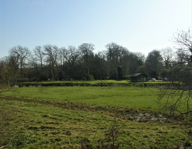
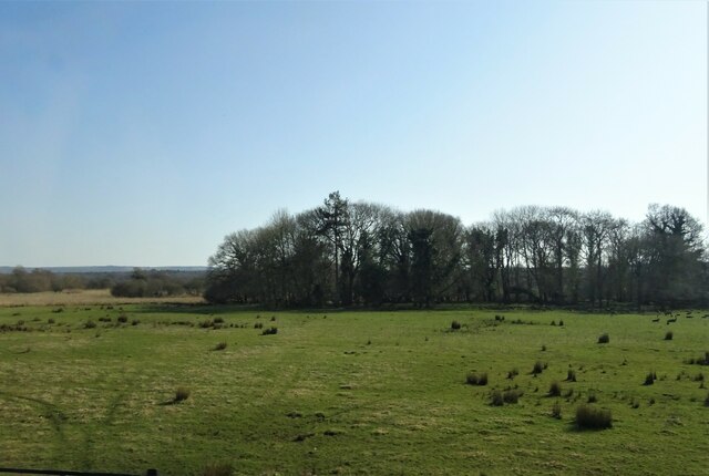
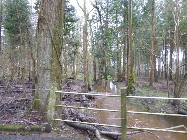
Long Coppice is a picturesque woodland located in the county of Dorset, England. Covering an area of approximately 100 acres, it is known for its diverse range of flora and fauna, making it a haven for nature enthusiasts and wildlife lovers alike.
The woodland is predominantly made up of coppiced trees, which refers to the traditional practice of periodically cutting trees at the base to promote growth and encourage the production of timber. This sustainable method of woodland management has been practiced at Long Coppice for centuries, resulting in a rich and varied habitat for a multitude of species.
Walking through Long Coppice, visitors are greeted by a canopy of towering oak, ash, and beech trees that provide a sheltered and tranquil atmosphere. The forest floor is carpeted with an array of wildflowers, including bluebells, primroses, and wood anemones, creating a vibrant tapestry of colors during the spring months.
The woodland is home to a diverse range of wildlife, including deer, badgers, foxes, and a variety of bird species such as woodpeckers, owls, and warblers. Rare butterflies, such as the silver-washed fritillary, can also be spotted fluttering amongst the trees.
Long Coppice offers a number of walking trails, allowing visitors to explore its natural beauty at their own pace. The woodland is managed by a local conservation organization, ensuring its preservation for future generations to enjoy. Whether it's a leisurely stroll, birdwatching, or simply immersing oneself in the tranquility of nature, Long Coppice is a true gem of Dorset's natural landscape.
If you have any feedback on the listing, please let us know in the comments section below.
Long Coppice Images
Images are sourced within 2km of 50.673094/-2.1903852 or Grid Reference SY8685. Thanks to Geograph Open Source API. All images are credited.
![Wool houses [22] Kingfisher Cottage, number 61 Church Lane, was probably built in the 18th century. Constructed of pebbledashed cob under a thatch roof. There is a later rear extension. Listed, grade II, with details at: <span class="nowrap"><a title="https://historicengland.org.uk/listing/the-list/list-entry/1120363" rel="nofollow ugc noopener" href="https://historicengland.org.uk/listing/the-list/list-entry/1120363">Link</a><img style="margin-left:2px;" alt="External link" title="External link - shift click to open in new window" src="https://s1.geograph.org.uk/img/external.png" width="10" height="10"/></span>
Wool is a large village in Dorset, midway between Dorchester and Poole, both about 10 miles distant. Set on the south bank of the River Frome, the village includes Bovington Camp army base to the north. The place-name &#039;Wool&#039; is first recorded in Anglo-Saxon Writs in the first years of the 11th century. The ruins of Bindon Abbey are nearby, demolished in 1539, the stone was used to build castles in Portland, Lulworth and Sandsfoot.](https://s3.geograph.org.uk/geophotos/07/25/88/7258863_3ec885ee.jpg)
![Wool houses [23] Melissa Cottage, number 62 Church Lane, was built in the 18th century, altered in the 19th century and extended in the late 20th century. Constructed of plastered cob on a stone base under a tile roof. Most of the windows are
horizontally sliding sashes. Listed, for group value, grade II, with details at: <span class="nowrap"><a title="https://historicengland.org.uk/listing/the-list/list-entry/1323394" rel="nofollow ugc noopener" href="https://historicengland.org.uk/listing/the-list/list-entry/1323394">Link</a><img style="margin-left:2px;" alt="External link" title="External link - shift click to open in new window" src="https://s1.geograph.org.uk/img/external.png" width="10" height="10"/></span>
Wool is a large village in Dorset, midway between Dorchester and Poole, both about 10 miles distant. Set on the south bank of the River Frome, the village includes Bovington Camp army base to the north. The place-name &#039;Wool&#039; is first recorded in Anglo-Saxon Writs in the first years of the 11th century. The ruins of Bindon Abbey are nearby, demolished in 1539, the stone was used to build castles in Portland, Lulworth and Sandsfoot.](https://s1.geograph.org.uk/geophotos/07/25/88/7258865_bea37e67.jpg)
![Wool houses [24] The Thatched Cottage, number 64 Church Lane, was probably built in the 18th century, possibly incorporating an earlier structure. Constructed partly of plastered cob, partly of brick, on a stone base, all under a thatch roof. Many of the windows are horizontally sliding sashes. Listed, grade II, with details at: <span class="nowrap"><a title="https://historicengland.org.uk/listing/the-list/list-entry/1323393" rel="nofollow ugc noopener" href="https://historicengland.org.uk/listing/the-list/list-entry/1323393">Link</a><img style="margin-left:2px;" alt="External link" title="External link - shift click to open in new window" src="https://s1.geograph.org.uk/img/external.png" width="10" height="10"/></span>
Wool is a large village in Dorset, midway between Dorchester and Poole, both about 10 miles distant. Set on the south bank of the River Frome, the village includes Bovington Camp army base to the north. The place-name &#039;Wool&#039; is first recorded in Anglo-Saxon Writs in the first years of the 11th century. The ruins of Bindon Abbey are nearby, demolished in 1539, the stone was used to build castles in Portland, Lulworth and Sandsfoot.](https://s1.geograph.org.uk/geophotos/07/25/89/7258905_89f5f701.jpg)
![Parish church [1] The Anglican parish church of The Holy Rood was built, nave only, in the 13th century, the chancel, north arcade and tower were added circa 1450. In 1865 the church was demolished except for the tower and north and east walls of the nave, and rebuilt. Constructed of rubble stone with free stone dressings under roofs of tile or of lead. The font is 15th century, other internal fittings are 19th century. Listed, grade II*, with details at: <span class="nowrap"><a title="https://historicengland.org.uk/listing/the-list/list-entry/1120365" rel="nofollow ugc noopener" href="https://historicengland.org.uk/listing/the-list/list-entry/1120365">Link</a><img style="margin-left:2px;" alt="External link" title="External link - shift click to open in new window" src="https://s1.geograph.org.uk/img/external.png" width="10" height="10"/></span>
Wool is a large village in Dorset, midway between Dorchester and Poole, both about 10 miles distant. Set on the south bank of the River Frome, the village includes Bovington Camp army base to the north. The place-name &#039;Wool&#039; is first recorded in Anglo-Saxon Writs in the first years of the 11th century. The ruins of Bindon Abbey are nearby, demolished in 1539, the stone was used to build castles in Portland, Lulworth and Sandsfoot.](https://s1.geograph.org.uk/geophotos/07/25/89/7258909_5d802de1.jpg)
![Parish church [2] The Anglican parish church of The Holy Rood was built, nave only, in the 13th century, the chancel, north arcade and tower were added circa 1450. In 1865 the church was demolished except for the tower and north and east walls of the nave, and rebuilt. Constructed of rubble stone with free stone dressings under roofs of tile or of lead. The font is 15th century, other internal fittings are 19th century. Listed, grade II*, with details at: <span class="nowrap"><a title="https://historicengland.org.uk/listing/the-list/list-entry/1120365" rel="nofollow ugc noopener" href="https://historicengland.org.uk/listing/the-list/list-entry/1120365">Link</a><img style="margin-left:2px;" alt="External link" title="External link - shift click to open in new window" src="https://s1.geograph.org.uk/img/external.png" width="10" height="10"/></span>
Wool is a large village in Dorset, midway between Dorchester and Poole, both about 10 miles distant. Set on the south bank of the River Frome, the village includes Bovington Camp army base to the north. The place-name &#039;Wool&#039; is first recorded in Anglo-Saxon Writs in the first years of the 11th century. The ruins of Bindon Abbey are nearby, demolished in 1539, the stone was used to build castles in Portland, Lulworth and Sandsfoot.](https://s2.geograph.org.uk/geophotos/07/25/89/7258910_36eaadd8.jpg)
![Parish church [3] The chancel.
The Anglican parish church of The Holy Rood was built, nave only, in the 13th century, the chancel, north arcade and tower were added circa 1450. In 1865 the church was demolished except for the tower and north and east walls of the nave, and rebuilt. Constructed of rubble stone with free stone dressings under roofs of tile or of lead. The font is 15th century, other internal fittings are 19th century. Listed, grade II*, with details at: <span class="nowrap"><a title="https://historicengland.org.uk/listing/the-list/list-entry/1120365" rel="nofollow ugc noopener" href="https://historicengland.org.uk/listing/the-list/list-entry/1120365">Link</a><img style="margin-left:2px;" alt="External link" title="External link - shift click to open in new window" src="https://s1.geograph.org.uk/img/external.png" width="10" height="10"/></span>
Wool is a large village in Dorset, midway between Dorchester and Poole, both about 10 miles distant. Set on the south bank of the River Frome, the village includes Bovington Camp army base to the north. The place-name &#039;Wool&#039; is first recorded in Anglo-Saxon Writs in the first years of the 11th century. The ruins of Bindon Abbey are nearby, demolished in 1539, the stone was used to build castles in Portland, Lulworth and Sandsfoot.](https://s3.geograph.org.uk/geophotos/07/25/89/7258911_cb7e2a3d.jpg)
![Parish church [4] The east window.
The Anglican parish church of The Holy Rood was built, nave only, in the 13th century, the chancel, north arcade and tower were added circa 1450. In 1865 the church was demolished except for the tower and north and east walls of the nave, and rebuilt. Constructed of rubble stone with free stone dressings under roofs of tile or of lead. The font is 15th century, other internal fittings are 19th century. Listed, grade II*, with details at: <span class="nowrap"><a title="https://historicengland.org.uk/listing/the-list/list-entry/1120365" rel="nofollow ugc noopener" href="https://historicengland.org.uk/listing/the-list/list-entry/1120365">Link</a><img style="margin-left:2px;" alt="External link" title="External link - shift click to open in new window" src="https://s1.geograph.org.uk/img/external.png" width="10" height="10"/></span>
Wool is a large village in Dorset, midway between Dorchester and Poole, both about 10 miles distant. Set on the south bank of the River Frome, the village includes Bovington Camp army base to the north. The place-name &#039;Wool&#039; is first recorded in Anglo-Saxon Writs in the first years of the 11th century. The ruins of Bindon Abbey are nearby, demolished in 1539, the stone was used to build castles in Portland, Lulworth and Sandsfoot.](https://s0.geograph.org.uk/geophotos/07/25/89/7258912_813e7f7c.jpg)
![Parish church [5] The organ.
The Anglican parish church of The Holy Rood was built, nave only, in the 13th century, the chancel, north arcade and tower were added circa 1450. In 1865 the church was demolished except for the tower and north and east walls of the nave, and rebuilt. Constructed of rubble stone with free stone dressings under roofs of tile or of lead. The font is 15th century, other internal fittings are 19th century. Listed, grade II*, with details at: <span class="nowrap"><a title="https://historicengland.org.uk/listing/the-list/list-entry/1120365" rel="nofollow ugc noopener" href="https://historicengland.org.uk/listing/the-list/list-entry/1120365">Link</a><img style="margin-left:2px;" alt="External link" title="External link - shift click to open in new window" src="https://s1.geograph.org.uk/img/external.png" width="10" height="10"/></span>
Wool is a large village in Dorset, midway between Dorchester and Poole, both about 10 miles distant. Set on the south bank of the River Frome, the village includes Bovington Camp army base to the north. The place-name &#039;Wool&#039; is first recorded in Anglo-Saxon Writs in the first years of the 11th century. The ruins of Bindon Abbey are nearby, demolished in 1539, the stone was used to build castles in Portland, Lulworth and Sandsfoot.](https://s1.geograph.org.uk/geophotos/07/25/89/7258913_eaf612ba.jpg)
![Parish church [6] The 15th century font, unusually built against a pier of the north arcade.
The Anglican parish church of The Holy Rood was built, nave only, in the 13th century, the chancel, north arcade and tower were added circa 1450. In 1865 the church was demolished except for the tower and north and east walls of the nave, and rebuilt. Constructed of rubble stone with free stone dressings under roofs of tile or of lead. The font is 15th century, other internal fittings are 19th century. Listed, grade II*, with details at: <span class="nowrap"><a title="https://historicengland.org.uk/listing/the-list/list-entry/1120365" rel="nofollow ugc noopener" href="https://historicengland.org.uk/listing/the-list/list-entry/1120365">Link</a><img style="margin-left:2px;" alt="External link" title="External link - shift click to open in new window" src="https://s1.geograph.org.uk/img/external.png" width="10" height="10"/></span>
Wool is a large village in Dorset, midway between Dorchester and Poole, both about 10 miles distant. Set on the south bank of the River Frome, the village includes Bovington Camp army base to the north. The place-name &#039;Wool&#039; is first recorded in Anglo-Saxon Writs in the first years of the 11th century. The ruins of Bindon Abbey are nearby, demolished in 1539, the stone was used to build castles in Portland, Lulworth and Sandsfoot.](https://s2.geograph.org.uk/geophotos/07/25/89/7258914_62191164.jpg)
![Parish church [7] Part of the large churchyard.
The Anglican parish church of The Holy Rood was built, nave only, in the 13th century, the chancel, north arcade and tower were added circa 1450. In 1865 the church was demolished except for the tower and north and east walls of the nave, and rebuilt. Constructed of rubble stone with free stone dressings under roofs of tile or of lead. The font is 15th century, other internal fittings are 19th century. Listed, grade II*, with details at: <span class="nowrap"><a title="https://historicengland.org.uk/listing/the-list/list-entry/1120365" rel="nofollow ugc noopener" href="https://historicengland.org.uk/listing/the-list/list-entry/1120365">Link</a><img style="margin-left:2px;" alt="External link" title="External link - shift click to open in new window" src="https://s1.geograph.org.uk/img/external.png" width="10" height="10"/></span>
Wool is a large village in Dorset, midway between Dorchester and Poole, both about 10 miles distant. Set on the south bank of the River Frome, the village includes Bovington Camp army base to the north. The place-name &#039;Wool&#039; is first recorded in Anglo-Saxon Writs in the first years of the 11th century. The ruins of Bindon Abbey are nearby, demolished in 1539, the stone was used to build castles in Portland, Lulworth and Sandsfoot.](https://s3.geograph.org.uk/geophotos/07/25/89/7258915_175d223f.jpg)
![Parish church [8] Part of the large churchyard.
The Anglican parish church of The Holy Rood was built, nave only, in the 13th century, the chancel, north arcade and tower were added circa 1450. In 1865 the church was demolished except for the tower and north and east walls of the nave, and rebuilt. Constructed of rubble stone with free stone dressings under roofs of tile or of lead. The font is 15th century, other internal fittings are 19th century. Listed, grade II*, with details at: <span class="nowrap"><a title="https://historicengland.org.uk/listing/the-list/list-entry/1120365" rel="nofollow ugc noopener" href="https://historicengland.org.uk/listing/the-list/list-entry/1120365">Link</a><img style="margin-left:2px;" alt="External link" title="External link - shift click to open in new window" src="https://s1.geograph.org.uk/img/external.png" width="10" height="10"/></span>
Wool is a large village in Dorset, midway between Dorchester and Poole, both about 10 miles distant. Set on the south bank of the River Frome, the village includes Bovington Camp army base to the north. The place-name &#039;Wool&#039; is first recorded in Anglo-Saxon Writs in the first years of the 11th century. The ruins of Bindon Abbey are nearby, demolished in 1539, the stone was used to build castles in Portland, Lulworth and Sandsfoot.](https://s0.geograph.org.uk/geophotos/07/25/89/7258916_38c2ad12.jpg)

Long Coppice is located at Grid Ref: SY8685 (Lat: 50.673094, Lng: -2.1903852)
Unitary Authority: Dorset
Police Authority: Dorset
What 3 Words
///goods.unfair.syndicate. Near Wool, Dorset
Nearby Locations
Related Wikis

East Stoke, Dorset
East Stoke is a village in the English county of Dorset. It lies three miles west of the small town of Wareham and two miles east of Wool. In 2013 the...
Wool, Dorset
Wool is a large village, civil parish and electoral ward in south Dorset, England. In the 2011 census the parish – which includes Bovington Camp army base...

Bindon Abbey
Bindon Abbey (Bindonium) was a Cistercian monastery, of which only ruins remain, on the River Frome about half a mile east of Wool in the Purbeck District...

Wool railway station
Wool railway station serves the village of Wool in Dorset, England. It is on the South West Main Line, 125 miles 69 chains (202.6 km) down the line from...

Woolbridge Manor House
Woolbridge Manor is a 17th-century manor house just outside the village of Wool, in Dorset, England. English Heritage have designated it a Grade II* listed...

Coombe Keynes
Coombe Keynes is a hamlet, civil parish and depopulated village in the Purbeck district of Dorset, England. The village is about 2 miles (3 km) south of...

East Holme
East Holme is a small village and civil parish situated about halfway between Wool and Wareham in Dorset, England. The village is sprawled around a large...
Holy Rood Church, Coombe Keynes
Holy Rood Church is a former Church of England church in Coombe Keynes, Dorset, England. Most of the church dates to a rebuild of 1860–61, but the tower...
Nearby Amenities
Located within 500m of 50.673094,-2.1903852Have you been to Long Coppice?
Leave your review of Long Coppice below (or comments, questions and feedback).