Wig Stones Allotment
Downs, Moorland in Yorkshire Craven
England
Wig Stones Allotment

Wig Stones Allotment is a picturesque and historic piece of land located in the heart of Yorkshire, England. Situated amidst the stunning landscape of the Yorkshire Downs and Moorland, this allotment offers a serene and idyllic setting for gardening enthusiasts.
Covering an area of approximately 5 acres, Wig Stones Allotment is divided into numerous smaller plots, each allocated to individuals or families who cultivate their own fruits, vegetables, and flowers. The allotment dates back several decades and has become a cherished community space for locals and visitors alike.
The fertile soil, abundant rainfall, and favorable climate in this region make the allotment an ideal place for growing a wide variety of crops. From potatoes and carrots to strawberries and rhubarb, the plots showcase a diverse range of produce throughout the year. Additionally, the allotment is home to a range of ornamental plants, which add beauty and color to the landscape.
Wig Stones Allotment also boasts a communal area with benches and picnic tables, providing a perfect spot for relaxation and socializing. Visitors can often be seen enjoying a cup of tea or engaging in friendly conversations with fellow gardeners. The tranquil surroundings and breathtaking views make it a popular destination for nature lovers and photographers.
Overall, Wig Stones Allotment in Yorkshire offers a unique opportunity for individuals to connect with nature, indulge in gardening activities, and be part of a vibrant community. It is a haven of calm and beauty, providing respite from the hustle and bustle of everyday life.
If you have any feedback on the listing, please let us know in the comments section below.
Wig Stones Allotment Images
Images are sourced within 2km of 54.095418/-1.8785148 or Grid Reference SE0866. Thanks to Geograph Open Source API. All images are credited.


Wig Stones Allotment is located at Grid Ref: SE0866 (Lat: 54.095418, Lng: -1.8785148)
Division: West Riding
Administrative County: North Yorkshire
District: Craven
Police Authority: North Yorkshire
What 3 Words
///mango.swung.removed. Near Pateley Bridge, North Yorkshire
Nearby Locations
Related Wikis
Grimwith Reservoir
Grimwith Reservoir is located in the Yorkshire Dales in North Yorkshire, England. It was originally built by the Bradford Corporation as one of eleven...

Stump Cross Caverns
Stump Cross Caverns is a limestone cave system between Wharfedale and Nidderdale in North Yorkshire, England. == Geography == The caverns at Stump Cross...

Greenhow
Greenhow is a village in North Yorkshire, England, often referred to as Greenhow Hill. The term how derives from the Old Norse word haugr meaning a hill...
Stonebeck Down
Stonebeck Down is a civil parish in Harrogate district, North Yorkshire, England. The main settlements in the parish are the village of Ramsgill and the...
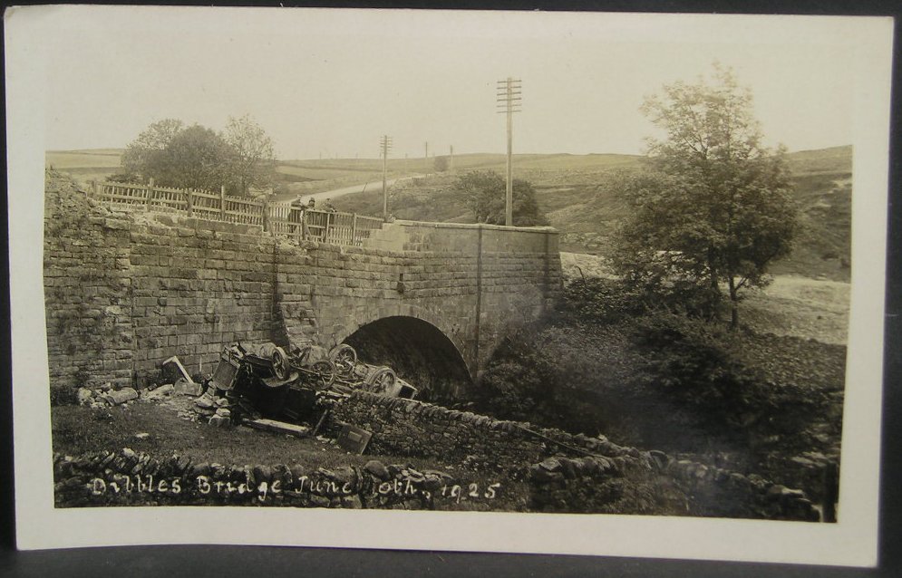
1925 Dibbles Bridge coach crash
On 10 June 1925, a coach crashed at the bottom of a steep hill at Dibbles Bridge, near Hebden in North Yorkshire, England. Seven people were killed and...

1975 Dibbles Bridge coach crash
On 27 May 1975, a coach carrying elderly passengers crashed at the bottom of a steep hill at Dibble's Bridge, near Hebden in North Yorkshire, England....

Trollers Gill
Trollers Gill is a limestone gill or gorge in North Yorkshire, England, close to the village of Skyreholme and 4.7 miles (7.5 km) south-east of Grassington...

Meugher
Meugher (/ˈmuː.fər/) is a hill in the Yorkshire Dales, England. It lies in remote country between Wharfedale and Nidderdale, in the parish of Stonebeck...
Nearby Amenities
Located within 500m of 54.095418,-1.8785148Have you been to Wig Stones Allotment?
Leave your review of Wig Stones Allotment below (or comments, questions and feedback).