Barnett's Down

Downs, Moorland in Wiltshire

England

Barnett's Down

Martins Barn, Mount Sorrel The lane from Bowerchalke crosses the River Chalke just before passing this impressive building. <a href="https://www.geograph.org.uk/photo/4547191">SU0324 : River Chalke at Mount Sorrel</a> was taken from the bridge.
Martins Barn, Mount Sorrel Credit: Derek Harper

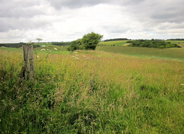
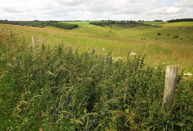
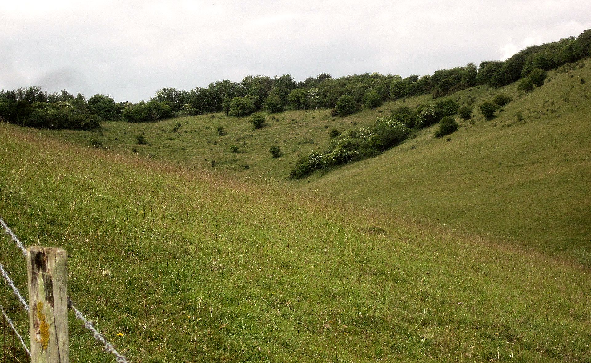
Barnett's Down is a picturesque area located in Wiltshire, England. Situated amidst the stunning landscape of the Downs and Moorland, it is known for its natural beauty and serene surroundings.

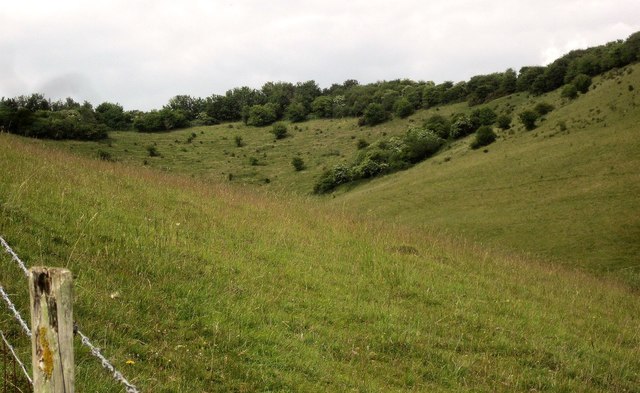
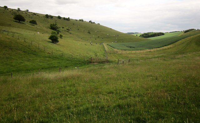
Covering an extensive stretch of land, Barnett's Down offers a diverse range of landscapes, including rolling hills, open fields, and dense woodlands. The area is home to an abundance of wildlife, including various species of birds, mammals, and flora. It is a haven for nature lovers and provides numerous opportunities for outdoor activities such as hiking, birdwatching, and photography.

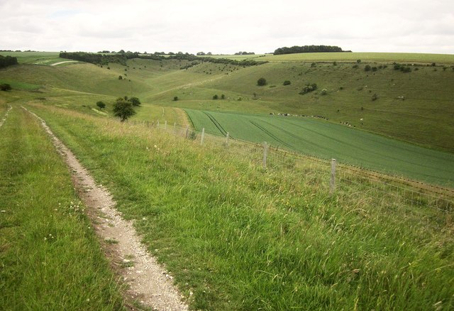
The terrain of Barnett's Down is characterized by its undulating hills and valleys, providing breathtaking panoramic views of the surrounding countryside. The area is dotted with charming villages and historic landmarks, adding to the allure of the landscape. Visitors can explore quaint country pubs, traditional cottages, and ancient monuments that showcase the rich history and culture of Wiltshire.

Barnett's Down is well-connected by a network of footpaths and trails, allowing visitors to explore the area at their own pace. The trails offer a mix of easy walks and more challenging hikes, catering to all levels of fitness and experience. The area is also popular for horse riding and cycling, with designated routes available for enthusiasts.

In summary, Barnett's Down in Wiltshire is a stunning location that offers a variety of natural landscapes, abundant wildlife, and opportunities for outdoor activities. Its idyllic charm, combined with its rich history and cultural heritage, makes it a must-visit destination for nature enthusiasts and those seeking tranquility amidst the beauty of the English countryside.

If you have any feedback on the listing, please let us know in the comments section below.

Barnett's Down Images

Images are sourced within 2km of 51.041556/-1.9586992 or Grid Reference SU0226. Thanks to Geograph Open Source API. All images are credited.
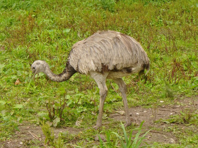
Martins Barn, Mount Sorrel The lane from Bowerchalke crosses the River Chalke just before passing this impressive building. <a href="https://www.geograph.org.uk/photo/4547191">SU0324 : River Chalke at Mount Sorrel</a> was taken from the bridge.
Martins Barn, Mount Sorrel
The lane from Bowerchalke crosses the River Chalke just before passing this impressive building. SU0324 : River Chalke at Mount Sorrel was taken from the bridge.
River Chalke at Mount Sorrel Looking upstream as the little river runs beside the road. On the left is <a href="https://www.geograph.org.uk/photo/4745301">SU0324 : Martins Barn, Mount Sorrel</a>.
River Chalke at Mount Sorrel
Looking upstream as the little river runs beside the road. On the left is SU0324 : Martins Barn, Mount Sorrel.
River Chalke at Cliff Side The laneside stream passes a pair of semis southwest of Broad Chalke.
River Chalke at Cliff Side
The laneside stream passes a pair of semis southwest of Broad Chalke.
River Chalke at Cliff Side A reverse view of <a href="https://www.geograph.org.uk/photo/4745347">SU0325 : River Chalke at Cliff Side</a>, from the junction of Knapp Hill and South Street.
River Chalke at Cliff Side
A reverse view of SU0325 : River Chalke at Cliff Side, from the junction of Knapp Hill and South Street.
Watercress beds at Broad Chalke See <a title="https://www.geograph.org.uk/discuss/index.php?action=vthread&topic=15556" href="https://www.geograph.org.uk/discuss/index.php?action=vthread&topic=15556">Link</a> . This is beside Knapp Hill.
Watercress beds at Broad Chalke
See Link . This is beside Knapp Hill.
On bridleway BROA 21 Trees along a field boundary that heads towards the dry valley below Knapp Down.
On bridleway BROA 21
Trees along a field boundary that heads towards the dry valley below Knapp Down.
Track across access land to Knapp Down A little further down the track shown in <a href="https://www.geograph.org.uk/photo/4554031">SU0226 : Track across access land to Knapp Down</a>.
Track across access land to Knapp Down
A little further down the track shown in SU0226 : Track across access land to Knapp Down.
Dry valley, Knapp Down Looking up to the head of the valley shown in <a href="https://www.geograph.org.uk/photo/4549940">SU0227 : Dry valley, Knapp Down</a>.
Dry valley, Knapp Down
Looking up to the head of the valley shown in SU0227 : Dry valley, Knapp Down.
Dry valley, Knapp Down Looking down the valley shown in <a href="https://www.geograph.org.uk/photo/4554040">SU0226 : Valley below Knapp Down</a>. Having reached the gate in the centre and pondered things awhile, the cattle have now turned around and dispersed.
Dry valley, Knapp Down
Looking down the valley shown in SU0226 : Valley below Knapp Down. Having reached the gate in the centre and pondered things awhile, the cattle have now turned around and dispersed.
View from Gurston Down The view north from bridleway BROA 21 towards the system of dry valleys below Knapp Down shown in <a href="https://www.geograph.org.uk/photo/4554031">SU0226 : Track across access land to Knapp Down</a>.
View from Gurston Down
The view north from bridleway BROA 21 towards the system of dry valleys below Knapp Down shown in SU0226 : Track across access land to Knapp Down.
Two of the Fovant Badges Two of a line of regimental badges cut into the chalk down by troops stationed nearby during the first world war. <span class="nowrap"><a title="https://en.wikipedia.org/wiki/Fovant_Badges" rel="nofollow ugc noopener" href="https://en.wikipedia.org/wiki/Fovant_Badges">Link</a><img style="margin-left:2px;" alt="External link" title="External link - shift click to open in new window" src="https://s1.geograph.org.uk/img/external.png" width="10" height="10"/></span>
Shown here are the 6th City of London Regiment <span class="nowrap"><a title="https://en.wikipedia.org/wiki/City_of_London_Rifles" rel="nofollow ugc noopener" href="https://en.wikipedia.org/wiki/City_of_London_Rifles">Link</a><img style="margin-left:2px;" alt="External link" title="External link - shift click to open in new window" src="https://s1.geograph.org.uk/img/external.png" width="10" height="10"/></span> and the Australian Commonwealth Military Forces. <span class="nowrap"><a title="https://en.wikipedia.org/wiki/History_of_the_Australian_Army" rel="nofollow ugc noopener" href="https://en.wikipedia.org/wiki/History_of_the_Australian_Army">Link</a><img style="margin-left:2px;" alt="External link" title="External link - shift click to open in new window" src="https://s1.geograph.org.uk/img/external.png" width="10" height="10"/></span>
Two of the Fovant Badges
Two of a line of regimental badges cut into the chalk down by troops stationed nearby during the first world war. LinkExternal link Shown here are the 6th City of London Regiment LinkExternal link and the Australian Commonwealth Military Forces. LinkExternal link
Broad Chalke - The Queen's Head Pub on North Street in the centre of Broad Chalke village.
Broad Chalke - The Queen's Head
Pub on North Street in the centre of Broad Chalke village.
Broad Chalke - River Ebble A study in green beside Broad Chalke Church.
Broad Chalke - River Ebble
A study in green beside Broad Chalke Church.
Chalk Stream Good stream for trout fishermen and for watercress at Broad Chalke in the Wiltshire Downs.
Chalk Stream
Good stream for trout fishermen and for watercress at Broad Chalke in the Wiltshire Downs.
Ostrich Egg Uncommon product at Broad Chalke, Wiltshire. [The average length of an ostrich egg is ca. 6 inches]. The village has an ostrich-rearing smallholding.
Ostrich Egg
Uncommon product at Broad Chalke, Wiltshire. [The average length of an ostrich egg is ca. 6 inches]. The village has an ostrich-rearing smallholding.
Broad Chalke - Rhea A rare bird indeed - on a smallholding in Broad Chalke, Wiltshire.
Broad Chalke - Rhea
A rare bird indeed - on a smallholding in Broad Chalke, Wiltshire.
Fovant Badges Fovant Down with some of its chalky regimental badges, seen from East Farm.
Fovant Badges
Fovant Down with some of its chalky regimental badges, seen from East Farm.
Show me another place!

Barnett's Down is located at Grid Ref: SU0226 (Lat: 51.041556, Lng: -1.9586992)

Unitary Authority: Wiltshire

Police Authority: Wiltshire

What 3 Words

///outcasts.race.skippers. Near Bishopstone, Wiltshire

Related Wikis

Knapp and Barnett's Downs

Knapp and Barnett's Downs (grid reference SU030266) is a 71.4 hectare biological Site of Special Scientific Interest in Wiltshire, notified in 1971....

Gurston Down Motorsport Hillclimb

The Gurston Down Speed Hill Climb is a hillclimb in Broad Chalke, Wiltshire, England, organised by the South Western Centre of the British Automobile Racing...

Chiselbury

Chiselbury is the site of an Iron Age univallate hillfort in Wiltshire, England. The hillfort is sub-circular in plan, and encloses an area of approximately...

River Chalke

The River Chalke is a small river within the English county of Wiltshire. It is the most significant tributary of the River Ebble. The river rises at Mead...
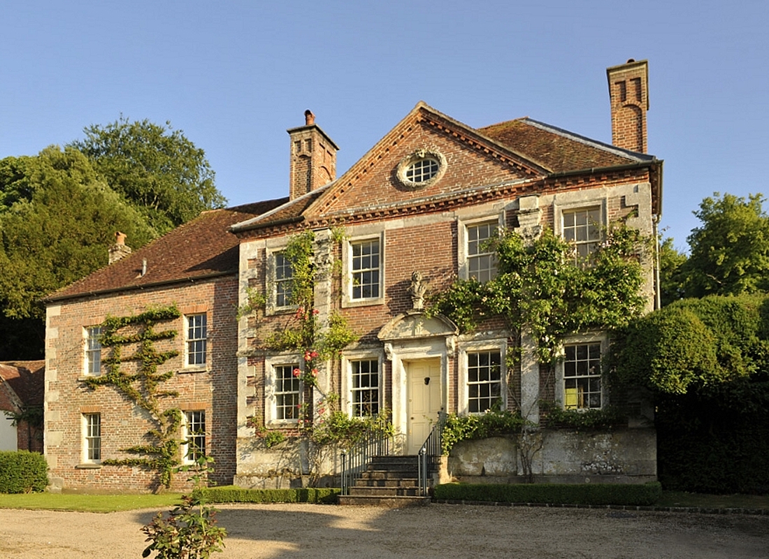
Reddish House

Reddish House, also known as Reddish Manor, is an early 18th-century manor house in the village of Broad Chalke in Wiltshire, England. It was possibly...

Broad Chalke

Broad Chalke, sometimes spelled Broadchalke, Broad Chalk or Broadchalk, is a village and civil parish in Wiltshire, England, about 8 miles (13 km) west...
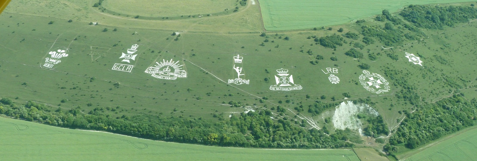
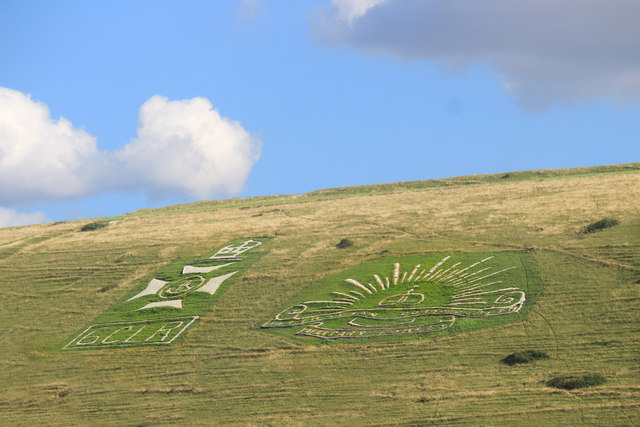
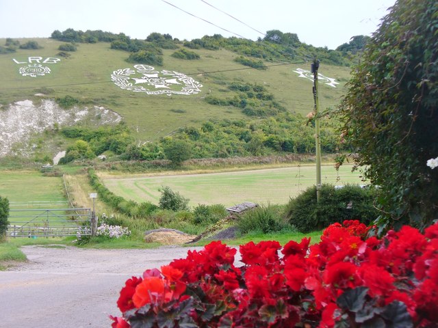
Fovant Badges

The Fovant Badges are a set of regimental badges cut into a chalk hill, Fovant Down, near Fovant, in south-west Wiltshire, England. They are between Salisbury...

Fifield Bavant

Fifield Bavant (/'fʌɪfiːld 'bavənt/) is a small village in the civil parish of Ebbesborne Wake, in Wiltshire, England, about 6 miles (10 km) southwest...

Related Videos

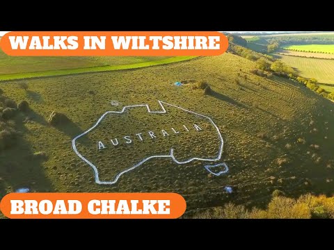
WALKS IN WILTSHIRE at BROAD CHALKE ( & THE AUSTRALIAN MAP ON COMPTON DOWN) (4K)

In this episode of my series “Walks in Wiltshire”, I take a 6 mile circular walk (with a “detour”) from the village of Broad Chalke ...

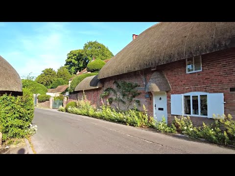
Broad Chalke Village Walk, English Countryside 4K

https://www.buymeacoffee.com/Daveswalks All support is hugely appreciated and it helps me keep the channel going! No talking ...

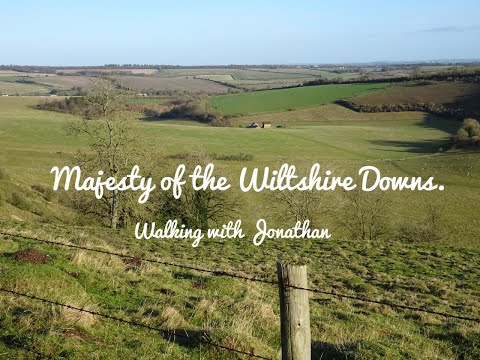
Majesty Of The Wiltshire Downs 18 miles circular

A walk through the Wiltshire Downs on the LDWA route titled Majesty Of The Wiltshire Downs, there was sun, there was rain and ...

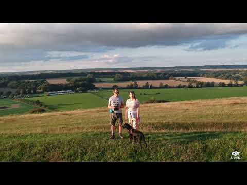
Fovant Badges, Salisbury, Wiltshire

Drone views whilst walking Lulu the black Labrador. #trustedhousesitters.

Nearby Amenities

Located within 500m of 51.041556,-1.9586992
The data included in this document is from www.openstreetmap.org. The data is made available under ODbL.

Have you been to Barnett's Down?

Leave your review of Barnett's Down below (or comments, questions and feedback).