St James's Green

Downs, Moorland in Roxburghshire

Scotland

St James's Green

Kelso Bridge Spanning the Tweed
Kelso Bridge Credit: Anthony O'Neil

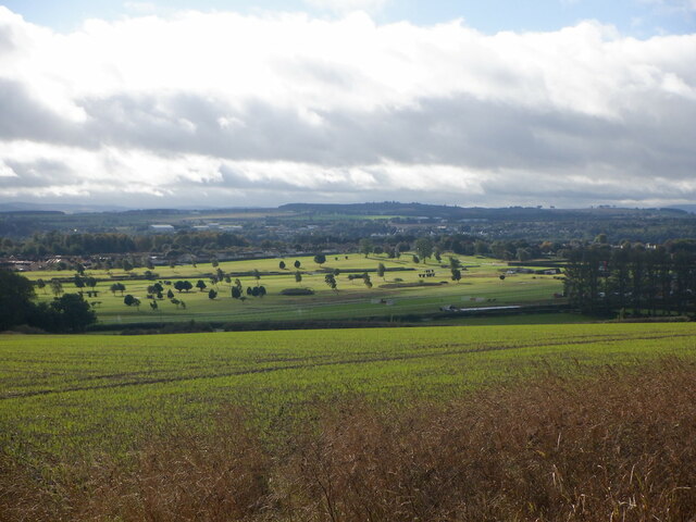
St James's Green is a picturesque area located in Roxburghshire, Scotland. It is renowned for its stunning natural beauty, characterized by rolling downs and vast moorland. Spanning approximately several square kilometers, this area offers a diverse landscape that attracts nature lovers and outdoor enthusiasts alike.

The downs of St James's Green feature gently sloping hills covered in lush green grass, creating a serene and idyllic setting. The open vistas provide ample opportunities for hiking, picnicking, and enjoying the stunning panoramic views of the surrounding countryside.

The moorland, on the other hand, presents a more rugged and wild landscape. Covered in heather and bracken, the moors of St James's Green are home to a variety of flora and fauna. Visitors can witness the vibrant colors of the blooming heather during the summer months and may even spot rare bird species and other wildlife.

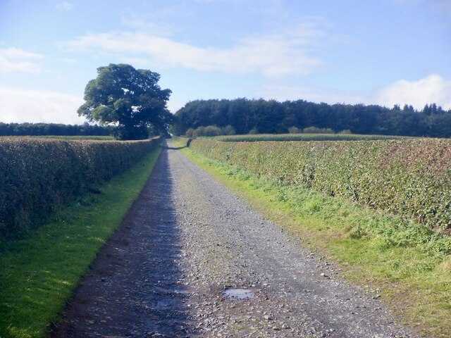
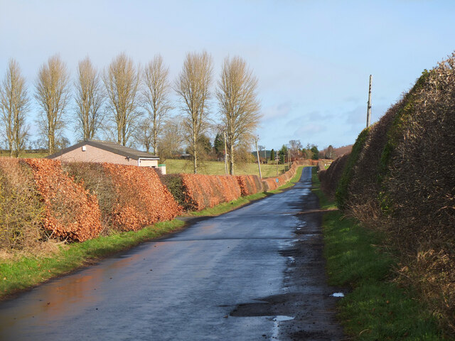
St James's Green also boasts several walking trails, allowing visitors to explore the area at their own pace. These trails take hikers through the downs and moorland, offering a chance to immerse themselves in the natural beauty and tranquility of the surroundings.

For those interested in history, St James's Green is also home to several archaeological sites, including ancient burial mounds and stone circles. These sites provide a glimpse into the area's rich and fascinating past.

Overall, St James's Green in Roxburghshire is a haven for nature enthusiasts, offering a diverse and captivating landscape that showcases the beauty of Scotland's countryside.

If you have any feedback on the listing, please let us know in the comments section below.

St James's Green Images

Images are sourced within 2km of 55.600585/-2.4443232 or Grid Reference NT7234. Thanks to Geograph Open Source API. All images are credited.

Kelso Bridge Spanning the Tweed
Kelso Bridge
Spanning the Tweed
High water River Tweed at Kelso
High water
River Tweed at Kelso
Kelso racecourse and golf course Like Ludlow, Kelso has a golf course on the inside of the racecourse. No road crossings though.
Kelso racecourse and golf course
Like Ludlow, Kelso has a golf course on the inside of the racecourse. No road crossings though.
Road, Floors Castle Newly trimmed hedges.
Road, Floors Castle
Newly trimmed hedges.
Hector Innes Photography Hector Innes Photography is located at 33 The Square, Kelso. The business was established in 1937.
Hector Innes Photography
Hector Innes Photography is located at 33 The Square, Kelso. The business was established in 1937.
Signs at Duns Wynd, Kelso Duns Wynd is off Roxburgh Street and the route of the Borders Abbeys Way to The Cobby, the north bank of the Tweed.
Signs at Duns Wynd, Kelso
Duns Wynd is off Roxburgh Street and the route of the Borders Abbeys Way to The Cobby, the north bank of the Tweed.
The Tweed at Kelso The Cobby is the green bank of the river east of the grounds of Floors Castle and a pleasant riverside walk.
The Tweed at Kelso
The Cobby is the green bank of the river east of the grounds of Floors Castle and a pleasant riverside walk.
Swans feeding at The Cobby, Kelso Swans on the grassy bank of the Tweed, also used as a short stretch of the Borders Abbeys Way.
Swans feeding at The Cobby, Kelso
Swans on the grassy bank of the Tweed, also used as a short stretch of the Borders Abbeys Way.
The Cobby, Kelso The grassy riverside area with a view of the town, in particular the Kelso North Parish Church.
The Cobby, Kelso
The grassy riverside area with a view of the town, in particular the Kelso North Parish Church.
Croft Park, Kelso A park with rugby pitches and a children's play area.
Croft Park, Kelso
A park with rugby pitches and a children's play area.
Kelso Health Centre The Health Centre on Inch Road, Kelso.
Kelso Health Centre
The Health Centre on Inch Road, Kelso.
Riverside path, Kelso A short stretch of path on the south bank of the Tweed between the old town bridge and the modern Hunter Bridge.
Riverside path, Kelso
A short stretch of path on the south bank of the Tweed between the old town bridge and the modern Hunter Bridge.
The Tweed and Hunter Bridge, Kelso Smooth water in the foreground becomes turbulent as it flows over the cauld (weir) between the left bank and the end of Wooden Anna island to the right. Water diverted around the right-hand side of Wooden Anna powered Wooden Mill before returning to the main river. The bridge carries the A698 Kelso by-pass.
The Tweed and Hunter Bridge, Kelso
Smooth water in the foreground becomes turbulent as it flows over the cauld (weir) between the left bank and the end of Wooden Anna island to the right. Water diverted around the right-hand side of Wooden Anna powered Wooden Mill before returning to the main river. The bridge carries the A698 Kelso by-pass.
Road under Hunter Bridge, Kelso The B6350 to Sprouston passes under the viaduct approach carrying the A698 to Hunter Bridge across the Tweed.
Road under Hunter Bridge, Kelso
The B6350 to Sprouston passes under the viaduct approach carrying the A698 to Hunter Bridge across the Tweed.
Hunter Bridge, Kelso A bridge for the A698 Kelso by-pass over the Tweed, opened in 1998. It comprises a  365m long viaduct of 13 spans to cross the Tweed, the island of Wooden Anna, an old mill lade and the B6350 road to Sprouston (information from 'Bridging the Tweed' by Jim Lyon, author publication 2019).
Hunter Bridge, Kelso
A bridge for the A698 Kelso by-pass over the Tweed, opened in 1998. It comprises a 365m long viaduct of 13 spans to cross the Tweed, the island of Wooden Anna, an old mill lade and the B6350 road to Sprouston (information from 'Bridging the Tweed' by Jim Lyon, author publication 2019).
Sign for riverside walk, Kelso Indicating the wide grassy bank of the Tweed to the west of the town centre.
Sign for riverside walk, Kelso
Indicating the wide grassy bank of the Tweed to the west of the town centre.
Minor road by Kelso racecourse A quiet road on the NW side of the course.
Minor road by Kelso racecourse
A quiet road on the NW side of the course.
Solar panels, Berryhill An array near the minor road north of Kelso racecourse.
Solar panels, Berryhill
An array near the minor road north of Kelso racecourse.
Show me another place!

St James's Green is located at Grid Ref: NT7234 (Lat: 55.600585, Lng: -2.4443232)

Unitary Authority: The Scottish Borders

Police Authority: The Lothians and Scottish Borders

What 3 Words

///fluctuate.renews.crashing. Near Kelso, Scottish Borders

Related Wikis

Kelso Hospital

Kelso Hospital, also known as Inch Hospital, is a health facility at Inch Road in Kelso, Scotland. It is managed by NHS Borders. == History == The hospital...

Kelso Town Hall

Kelso Town Hall is a municipal building in The Square, Kelso, Scotland. The building, which was the headquarters of Kelso Burgh Council, is a Category...

Kelso, Scottish Borders

Kelso is a market town in the Scottish Borders area of Scotland. Within the boundaries of the historic county of Roxburghshire, it lies where the rivers...

Corn Exchange, Kelso

The Corn Exchange is a commercial building in Woodmarket, Kelso, Scottish Borders, Scotland. The structure, which accommodates a health clinic, a dental...

Nearby Amenities

Located within 500m of 55.600585,-2.4443232
Post Box
Brand: Royal Mail
Brand Wikidata: Q638098
Mapillary: 317224529850279
Operator: Royal Mail
Operator Wikidata: Q638098
Post Box Mounting: stone_wall
Post Box Type: wall
Ref: TD5 24
Survey Date: 2020-09-13
Lat/Long: 55.6035462/-2.4424399
Bus Stop
Inch Road
Bench: yes
Bus: yes
Departures Board: timetable
Lit: no
Local Ref: nr
Naptan AtcoCode: 69001306
Naptan Bearing: N
Naptan CommonName: Inch Road
Naptan Indicator: nr
Naptan Landmark: Baptist Church
Naptan NaptanCode: 72726287
Naptan Street: Bowmont Street
Naptan Verified: yes
Operator: Scottish Borders Council
Public Transport: platform
Ref: 69001306
Route Ref: K13;52;65;66;67;80;81;81A
Shelter: yes
Source: local knowledge;survey;NaPTAN
Lat/Long: 55.6008158/-2.4365463
Croft Park
Local Ref: AT
Naptan AtcoCode: 69001330
Naptan Bearing: E
Naptan BusStopType: CUS
Naptan CommonName: Croft Park
Naptan Indicator: at
Naptan Landmark: Croft Park
Naptan NaptanCode: 72726282
Naptan Street: Croft Road
Naptan Verified: no
Source: naptan_import
Lat/Long: 55.6048529/-2.4423316
Bus Stop
Croft Park
Bus: yes
Naptan AtcoCode: 6900542
Naptan Bearing: SW
Naptan CommonName: Croft Park
Naptan Indicator: opp
Naptan Landmark: Croft Park
Naptan NaptanCode: 72723859
Naptan Street: Croft Road
Operator: Scottish Borders Council
Public Transport: platform
Ref: 6900542
Source: NaPTAN
Lat/Long: 55.6047814/-2.4422197
Bus Stop
Orchard Park
Bench: no
Bus: yes
Departures Board: no
Lit: yes
Local Ref: opp
Naptan AtcoCode: 6900544
Naptan Bearing: N
Naptan CommonName: Orchard Park
Naptan Indicator: opp
Naptan NaptanCode: 72723838
Naptan Street: Edinburgh Road
Operator: Scottish Borders Council
Public Transport: platform
Ref: 6900544
Shelter: no
Source: local knowledge;survey;NaPTAN
Lat/Long: 55.6035162/-2.4426661
Bus Stop
Orchard Park
Bench: no
Bus: yes
Departures Board: no
Lit: no
Local Ref: adj
Naptan AtcoCode: 6900566
Naptan Bearing: S
Naptan CommonName: Orchard Park
Naptan Indicator: adj
Naptan NaptanCode: 72723843
Naptan Street: Edinburgh Road
Operator: Scottish Borders Council
Public Transport: platform
Ref: 6900566
Shelter: no
Source: local knowledge;survey;NaPTAN
Lat/Long: 55.603776/-2.4428058
Bus Stop
British Legion
Bus: yes
Naptan AtcoCode: 6900579
Naptan Bearing: N
Naptan CommonName: British Legion
Naptan Indicator: o/s
Naptan Landmark: British Legion
Naptan NaptanCode: 72723785
Naptan Street: Roxburgh Street
Operator: Scottish Borders Council
Public Transport: platform
Ref: 6900579
Source: NaPTAN
Lat/Long: 55.5999408/-2.4364677
Bus Stop
Inch Park
Bench: no
Bus: yes
Departures Board: no
Lit: yes
Local Ref: at
Naptan AtcoCode: 6900582
Naptan Bearing: S
Naptan CommonName: Inch Park
Naptan Indicator: at
Naptan NaptanCode: 72723832
Naptan Street: Bowmont Street
Operator: Scottish Borders Council
Public Transport: platform
Ref: 6900582
Shelter: no
Source: local knowledge;survey;NaPTAN
Lat/Long: 55.6016357/-2.437407
The Back Bullers
Place: locality
Lat/Long: 55.5990709/-2.4387933
Addr Housenumber: 83d
Addr Street: Roxburgh Street
Source: survey
Lat/Long: 55.6002018/-2.4366039
Addr Housenumber: 85
Addr Street: Roxburgh Street
Source: survey
Lat/Long: 55.600343/-2.4367483
Booth: K6
Removed Amenity: telephone
Source: survey
Lat/Long: 55.6022915/-2.4386674
Site of medieval city of Roxburgh
Addr City: Roxburgh
Historic: archaeological_site
Lat/Long: 55.5988645/-2.4477828
Site of medieval town of Wester Kelso
Addr City: Wester Kelso
Historic: archaeological_site
Source: Archeological dig
Lat/Long: 55.6025845/-2.4459374
Parking
Friarshaugh
Access: customers
Parking: surface
Lat/Long: 55.5981238/-2.4410603
Cobby Overlook
Tourism: viewpoint
Lat/Long: 55.6001277/-2.4372207
Lady Bennett's Well
Natural: spring
Lat/Long: 55.6017429/-2.4409769
Barrier: entrance
Bicycle: no
Foot: yes
Lat/Long: 55.6020585/-2.4380847
Bench
Lat/Long: 55.6012539/-2.4385305
Bench
Lat/Long: 55.6012681/-2.4385708
Power: cable_distribution_cabinet
Lat/Long: 55.6013807/-2.4370092
Bench
Backrest: yes
Lat/Long: 55.6029628/-2.4418383
Tom Lillie's Well
Natural: spring
Lat/Long: 55.6017781/-2.4451419
Crossing
Crossing Island: yes
Lat/Long: 55.6010985/-2.4367598
Crossing
Crossing: uncontrolled
Crossing Island: no
Lat/Long: 55.6013593/-2.4368658
Defibrillator
Defibrillator Location: On outside wall of Royal British Legion, on Roxburgh Street
Emergency: defibrillator
Mapillary: 355392005918295
Survey Date: 2021-05-24
Lat/Long: 55.599924/-2.4365224
The data included in this document is from www.openstreetmap.org. The data is made available under ODbL.

Have you been to St James's Green?

Leave your review of St James's Green below (or comments, questions and feedback).