Millennium Lake
Lake, Pool, Pond, Freshwater Marsh in Hertfordshire Stevenage
England
Millennium Lake

Millennium Lake, located in Hertfordshire, is a serene and picturesque body of water that serves as a natural oasis for both wildlife and visitors alike. This man-made lake, also known as a pool or pond, covers an area of approximately 5 acres and is surrounded by lush greenery and gentle rolling hills.
The lake was created in the year 2000 as part of a rejuvenation project to enhance the natural beauty of the area. It is fed by freshwater sources, ensuring a clean and vibrant ecosystem. The water in Millennium Lake is crystal clear, reflecting the stunning scenery surrounding it.
This freshwater marsh is home to a diverse range of flora and fauna. The surrounding vegetation includes reeds, rushes, and water lilies, providing a habitat for numerous bird species, insects, and small mammals. Visitors can often spot swans gracefully gliding across the water, as well as ducks and geese wading in the shallows.
Millennium Lake offers a tranquil setting for recreational activities such as fishing and boating. Anglers can try their luck at catching various species of fish, including perch, roach, and carp. The lake is popular among locals and tourists who enjoy a peaceful day out surrounded by nature.
The lake is easily accessible, with designated walking paths and picnic areas for visitors to enjoy. It provides a perfect opportunity for nature enthusiasts to observe the local wildlife or simply unwind in a serene environment.
In conclusion, Millennium Lake in Hertfordshire is a stunning freshwater marsh that offers a tranquil and scenic retreat for both wildlife and visitors. Whether it's fishing, boating, or simply enjoying the beauty of nature, this picturesque lake is a must-visit destination in the area.
If you have any feedback on the listing, please let us know in the comments section below.
Millennium Lake Images
Images are sourced within 2km of 51.903433/-0.17918783 or Grid Reference TL2524. Thanks to Geograph Open Source API. All images are credited.


Millennium Lake is located at Grid Ref: TL2524 (Lat: 51.903433, Lng: -0.17918783)
Administrative County: Hertfordshire
District: Stevenage
Police Authority: Hertfordshire
What 3 Words
///label.banks.zones. Near Stevenage, Hertfordshire
Nearby Locations
Related Wikis

Marriotts School
Marriotts School is a secondary school in Stevenage, Hertfordshire, England. The school was rebuilt along with Lonsdale School (for special needs children...
The Nobel School
The Nobel School is a co-educational secondary school and sixth form located in Stevenage in the English county of Hertfordshire. == History == The Nobel...

Shephall
Shephall (SHEP-all) is a neighbourhood of the new town of Stevenage in Hertfordshire. It was formerly a separate village and parish, being absorbed into...

List of local nature reserves in Hertfordshire
Hertfordshire is a county in eastern England. It is bordered by Bedfordshire to the north, Cambridgeshire to the north-east, Essex to the east, Buckinghamshire...

The Heathcote School
The Heathcote School was an 11-18 comprehensive school in Stevenage, Hertfordshire. The school was founded in the 1950s. It was awarded Specialist Engineering...

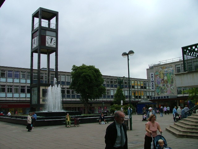
Stevenage Clock Tower
Stevenage Clock Tower is a Grade II listed structure in Town Square in the centre of Stevenage New Town. A panel on the tower records the visit of Elizabeth...
Barnwell School
Barnwell School is a coeducational secondary school and sixth form that was established in 1959 and is situated in the south of Stevenage, Hertfordshire...

Stevenage
Stevenage ( STEE-vən-ij) is a large town and borough in Hertfordshire, England, about 27 miles (43 km) north of London. Stevenage is east of junctions...
Nearby Amenities
Located within 500m of 51.903433,-0.17918783Have you been to Millennium Lake?
Leave your review of Millennium Lake below (or comments, questions and feedback).