Rudd Lake

Lake, Pool, Pond, Freshwater Marsh in Huntingdonshire Huntingdonshire

England

Rudd Lake

Paxton Road, Great Paxton At the end of the road to Toseland.
Paxton Road, Great Paxton Credit: David Howard

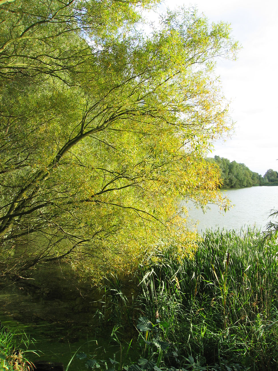
Rudd Lake is a picturesque freshwater body located in Huntingdonshire, a county in the eastern region of England. Nestled amidst a lush landscape, this lake is a renowned site for nature enthusiasts and those seeking tranquility.

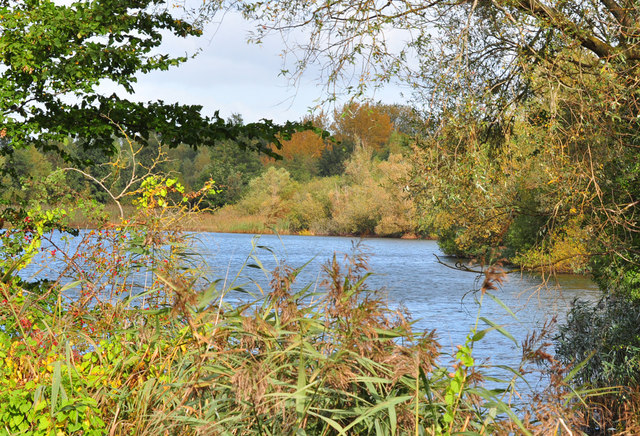
Spanning over an estimated area of 10 acres, Rudd Lake boasts crystal-clear waters that shimmer under the sunlight. It is primarily fed by natural springs and rainfall, ensuring a constant flow of freshwater. The lake is surrounded by abundant vegetation, including reeds and water lilies, which provide a habitat for various species of flora and fauna.

The lake's depths vary, with some areas reaching up to 10 feet, making it ideal for swimming and other water activities. It is also a popular spot for fishing, as it is home to a diverse range of fish species, including Rudd, after which the lake is named. Anglers can often be seen casting their lines in hopes of catching a prized fish.

Additionally, Rudd Lake is bordered by a freshwater marsh, adding to its ecological significance. This marshland is teeming with unique wetland species, such as frogs, dragonflies, and various bird species. Birdwatchers flock to the area to catch glimpses of elusive species like the great crested grebe and the marsh harrier.

Overall, Rudd Lake offers a serene and idyllic setting for visitors to immerse themselves in nature. Its combination of diverse wildlife, pristine waters, and lush surroundings make it a truly remarkable destination for anyone seeking a peaceful retreat in Huntingdonshire.

If you have any feedback on the listing, please let us know in the comments section below.

Rudd Lake Images

Images are sourced within 2km of 52.249372/-0.25307005 or Grid Reference TL1962. Thanks to Geograph Open Source API. All images are credited.

Paxton Road, Great Paxton At the end of the road to Toseland.
Paxton Road, Great Paxton
At the end of the road to Toseland.
Houses on Paxton Road, Great Paxton
Ibbetts in Great Paxton They sell agricultural machinery.
Ibbetts in Great Paxton
They sell agricultural machinery.
De-trained at St Neot's I alighted at St Neot's station, for the first time in my life.  Here we are looking north along platforms 3 and 4, the Thameslink train to Horsham still in the road for platform 4.
De-trained at St Neot's
I alighted at St Neot's station, for the first time in my life. Here we are looking north along platforms 3 and 4, the Thameslink train to Horsham still in the road for platform 4.
Platforms 1 and 2 The "frame" in this picture is the footbridge and its supporting legs.  The old style annunciator panels are probably going to be here for a while.  LNER has paid to update them on the stations they use, but St Neots is for Thameslink trains, so far less romantic.
Platforms 1 and 2
The "frame" in this picture is the footbridge and its supporting legs. The old style annunciator panels are probably going to be here for a while. LNER has paid to update them on the stations they use, but St Neots is for Thameslink trains, so far less romantic.
St Neot's station In failing light, with long shadows, it is nearly sundown.  We are looking North at St Neot's.
St Neot's station
In failing light, with long shadows, it is nearly sundown. We are looking North at St Neot's.
Dashing past An LNER Azuma, class 800, passing St Neots at high speed.  I stayed behind the yellow line, as bid.
Dashing past
An LNER Azuma, class 800, passing St Neots at high speed. I stayed behind the yellow line, as bid.
Longsands Road, St Neots Off Hawkesden Road.
Longsands Road, St Neots
Off Hawkesden Road.
Hawkesden Road, St Neots At its junction with Longsands Road.
Hawkesden Road, St Neots
At its junction with Longsands Road.
Corner House. Southoe
The end of High Street, Southoe This is as far as it goes.
The end of High Street, Southoe
This is as far as it goes.
Narrow path off High Street, Southoe
Town Orchard, Southoe
High Street, Southoe
Car  park  and  playing  field  on  Island  Common
Car park and playing field on Island Common
Traffic  lights  at  northern  end  of  islands  common New Street joins Mill Lane. Going from St Neots to the A1
Traffic lights at northern end of islands common
New Street joins Mill Lane. Going from St Neots to the A1
Mill  Lane  entering  Little  Paxton  over  River  Great  Ouse As the river is split  around an island the raised footbridge is a very long one. Village name sign far right, obscured by leaves.
Mill Lane entering Little Paxton over River Great Ouse
As the river is split around an island the raised footbridge is a very long one. Village name sign far right, obscured by leaves.
Pedestrian  crossing  on  Mill  Lane  B1041  Little  Paxton The raised footbridge over the River Great Ouse is on the left. It starts or finishes beyond the white van, whichever way you are walking
Pedestrian crossing on Mill Lane B1041 Little Paxton
The raised footbridge over the River Great Ouse is on the left. It starts or finishes beyond the white van, whichever way you are walking
Show me another place!

Rudd Lake is located at Grid Ref: TL1962 (Lat: 52.249372, Lng: -0.25307005)

Administrative County: Cambridgeshire

District: Huntingdonshire

Police Authority: Cambridgeshire

What 3 Words

///crazy.plotting.crusaders. Near Little Paxton, Cambridgeshire

Related Wikis

Little Paxton

Little Paxton in Cambridgeshire, England is a village and civil parish that lies 5 miles (8.0 km) south of Huntingdon and 1.7 miles (2.7 km) north of St...

Southoe

Southoe is a small village and former civil parish, now in the parish of Southoe and Midloe, in Cambridgeshire, England. Southoe lies approximately 6 miles...

Paxton Pits Nature Reserve

Paxton Pits is an area of active and disused gravel pits at Little Paxton near St Neots in Cambridgeshire, England. The disused pits have been turned into...

Little Paxton Pits

Little Paxton Pits is a 127.4-hectare (315-acre) biological Site of Special Scientific Interest in Little Paxton in Cambridgeshire. Part of it is also...

St Neots Rural District

St Neots was a rural district in Huntingdonshire, England from 1894 to 1974, around the northern and eastern sides of the urban area of St Neots. The district...

River Kym

The River Kym is a river in Cambridgeshire, England. It flows through the village of Tilbrook, to Kimbolton, and joins the Great Ouse at St Neots. It is...

St Neots Town F.C.

St Neots Town Football Club is an English semi-professional football club based in St Neots, Cambridgeshire. The club are currently members of the United...

St Neots Common

St Neots Common is a 33.4-hectare (83-acre) biological Site of Special Scientific Interest in St Neots in Cambridgeshire.This site on the east bank of...

Nearby Amenities

Located within 500m of 52.249372,-0.25307005
Created By: Merkaartor 0.12
Lat/Long: 52.2504658/-0.259391
Created By: Merkaartor 0.12
Lat/Long: 52.252829/-0.254854
Created By: Merkaartor 0.12
Lat/Long: 52.25274/-0.254037
Created By: Merkaartor 0.12
Lat/Long: 52.2516415/-0.2493595
Cafe
Paxton Pits Nature Reserve Visitor Centre Cafe
Lat/Long: 52.2515233/-0.2499071
Created By: Merkaartor 0.12
Lat/Long: 52.2484523/-0.257836
Created By: Merkaartor 0.12
Lat/Long: 52.2488336/-0.2591067
Created By: Merkaartor 0.12
Lat/Long: 52.2490369/-0.25937
Created By: Merkaartor 0.12
Lat/Long: 52.249285/-0.2595519
Created By: Merkaartor 0.12
Lat/Long: 52.249519/-0.25963
Bus Stop
Bus: yes
Public Transport: platform
Source: survey
Lat/Long: 52.2483344/-0.2591818
Created By: Merkaartor 0.12
Lat/Long: 52.251306/-0.257191
Created By: Merkaartor 0.12
Lat/Long: 52.251456/-0.2571369
Created By: Merkaartor 0.12
Lat/Long: 52.2519859/-0.2533869
Created By: Merkaartor 0.12
Lat/Long: 52.249533/-0.255778
Turning Circle
Source: survey
Lat/Long: 52.2493129/-0.2570355
Created By: Merkaartor 0.12
Lat/Long: 52.2496382/-0.2572774
Created By: Merkaartor 0.12
Lat/Long: 52.2468433/-0.2583664
Created By: Merkaartor 0.12
Lat/Long: 52.2469369/-0.257749
Created By: Merkaartor 0.12
Lat/Long: 52.2470108/-0.2575295
Created By: Merkaartor 0.12
Lat/Long: 52.24712/-0.2573549
Created By: Merkaartor 0.12
Lat/Long: 52.2472833/-0.2572828
Created By: Merkaartor 0.12
Lat/Long: 52.2465369/-0.258567
Barrier: kissing_gate
Foot: yes
Lat/Long: 52.2513441/-0.2497216
Bus Stop
Boardman Close
Bus: yes
Naptan AtcoCode: 0500HLITN007
Naptan Bearing: N
Naptan CommonName: Boardman Close
Naptan Indicator: N-bound
Naptan Landmark: High Street
Naptan NaptanCode: cmbdpmpw
Naptan ShortCommonName: Boardman Close
Naptan Street: Gordon Road
Naptan Verified: no
Public Transport: platform
Source: naptan_import
Lat/Long: 52.2498742/-0.2584371
Bus Stop
Boardman Close
Bus: yes
Naptan AtcoCode: 0500HLITN013
Naptan Bearing: S
Naptan CommonName: Boardman Close
Naptan Indicator: opp
Naptan Landmark: Boardman Close
Naptan NaptanCode: cmbdpmtp
Naptan ShortCommonName: Boardman Close
Naptan Street: Gordon Road
Naptan Verified: no
Public Transport: platform
Source: naptan_import
Lat/Long: 52.2487197/-0.2588046
Paxton Pits Nature Reserve Visitor Centre
Information: visitor_centre
Tourism: information
Lat/Long: 52.2515658/-0.2499118
Toilets
Lat/Long: 52.2515204/-0.2499911
Crossing
Lat/Long: 52.2516263/-0.2497337
Leisure: picnic_table
Lat/Long: 52.2514861/-0.2500955
Crossing
Lat/Long: 52.2516182/-0.249998
The data included in this document is from www.openstreetmap.org. The data is made available under ODbL.

Have you been to Rudd Lake?

Leave your review of Rudd Lake below (or comments, questions and feedback).