Hayling Lake

Lake, Pool, Pond, Freshwater Marsh in Huntingdonshire Huntingdonshire

England

Hayling Lake

Paxton Road, Great Paxton At the end of the road to Toseland.
Paxton Road, Great Paxton Credit: David Howard

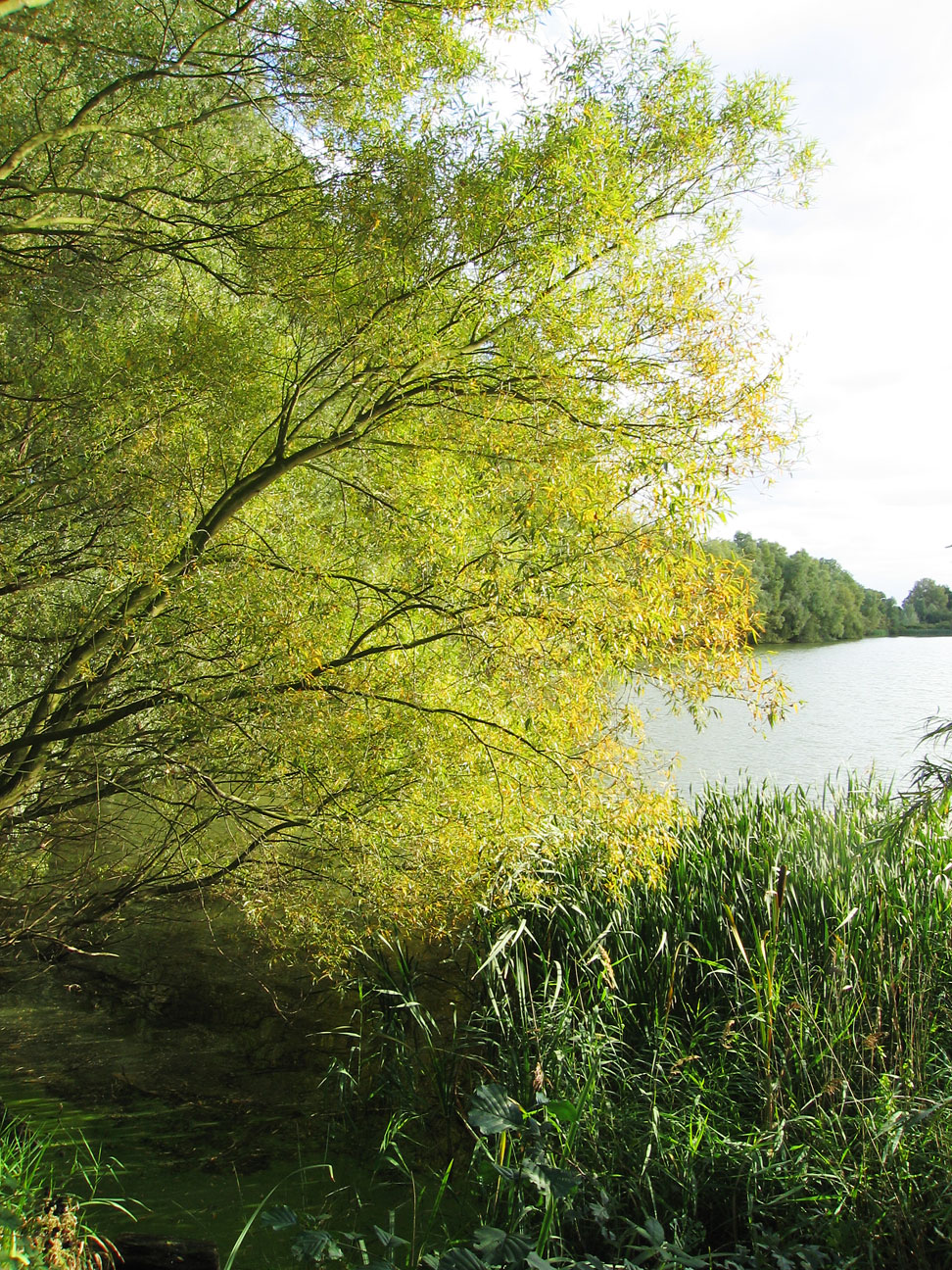
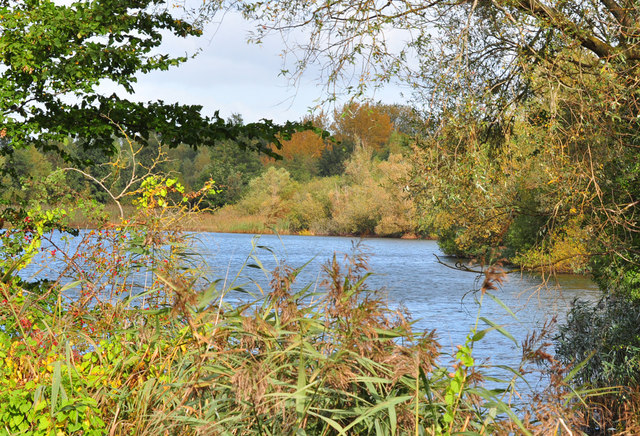
Hayling Lake is a picturesque freshwater body located in Huntingdonshire, England. Nestled amidst lush greenery, it is a popular destination for nature enthusiasts and anglers alike. The lake covers an area of approximately 10 acres and is surrounded by a diverse ecosystem that includes wetland habitats, pools, ponds, and freshwater marshes.

The lake itself is a serene and tranquil spot, offering breathtaking views and a sense of peace and serenity. Its calm waters are home to a variety of fish species, making it a haven for anglers seeking a quiet spot to cast their lines. Carp, pike, roach, and perch are some of the commonly found fish in Hayling Lake.

Surrounding the lake, visitors can explore the rich biodiversity of the area. The wetland habitats surrounding the lake are teeming with birdlife, making it a prime spot for birdwatching enthusiasts. Species such as herons, kingfishers, and various waterfowl can often be spotted along the lake's shores.

The area around Hayling Lake is also home to a range of plant species, creating a beautiful and vibrant landscape. From delicate water lilies to reeds and rushes, the freshwater marshes surrounding the lake provide a rich habitat for a variety of flora and fauna.

Overall, Hayling Lake in Huntingdonshire offers visitors a chance to immerse themselves in the beauty of nature. Whether it's fishing, birdwatching, or simply enjoying the peaceful ambiance, this freshwater body provides a welcome retreat from the hustle and bustle of everyday life.

If you have any feedback on the listing, please let us know in the comments section below.

Hayling Lake Images

Images are sourced within 2km of 52.246708/-0.25414148 or Grid Reference TL1962. Thanks to Geograph Open Source API. All images are credited.

Paxton Road, Great Paxton At the end of the road to Toseland.
Paxton Road, Great Paxton
At the end of the road to Toseland.
Houses on Paxton Road, Great Paxton
Ibbetts in Great Paxton They sell agricultural machinery.
Ibbetts in Great Paxton
They sell agricultural machinery.
St Neots railway station
De-trained at St Neot's I alighted at St Neot's station, for the first time in my life.  Here we are looking north along platforms 3 and 4, the Thameslink train to Horsham still in the road for platform 4.
De-trained at St Neot's
I alighted at St Neot's station, for the first time in my life. Here we are looking north along platforms 3 and 4, the Thameslink train to Horsham still in the road for platform 4.
Shelter and footbridge There isn't much to the station at St Neot's, beyond long platforms.  The footbridge gives access to all 4 platforms, and to the exits on both sides of the railway.  We are, of course, looking south here as the Thameslink train to Horsham prepares to depart.
Shelter and footbridge
There isn't much to the station at St Neot's, beyond long platforms. The footbridge gives access to all 4 platforms, and to the exits on both sides of the railway. We are, of course, looking south here as the Thameslink train to Horsham prepares to depart.
Hull Trains do not stop here Hull Trains operate a fleet of 5-car class 802 sets, which are bi-mode electric and diesel traction machines made by Hitachi.  Hitachi appear to dominate the east coast main line. Just as LNER call their class 801s "Azuma", Hull Trains call these "Paragon".
Hull Trains do not stop here
Hull Trains operate a fleet of 5-car class 802 sets, which are bi-mode electric and diesel traction machines made by Hitachi. Hitachi appear to dominate the east coast main line. Just as LNER call their class 801s "Azuma", Hull Trains call these "Paragon".
Station footbridge It's a clever arrangement this.  The footbridge crosses the whole width of the station, with elevators and stairs at each end for the public entrance.  In the middle a row of ticket barriers give access to the second bridge that accesses the platforms.
Station footbridge
It's a clever arrangement this. The footbridge crosses the whole width of the station, with elevators and stairs at each end for the public entrance. In the middle a row of ticket barriers give access to the second bridge that accesses the platforms.
Like a new town The Loves Farm development next to St Neot's station is essentially a new small town, dating from the first decade of the 21st century.
Like a new town
The Loves Farm development next to St Neot's station is essentially a new small town, dating from the first decade of the 21st century.
Help Point A posh version of an intercom next to the lift to the footbridge at St Neot's station
Help Point
A posh version of an intercom next to the lift to the footbridge at St Neot's station
Supermarket at the housing estate Part of the new Loves Farm development is this retail block, with a supermarket and a fast food outlet.  There is a pharmacy here too.
Supermarket at the housing estate
Part of the new Loves Farm development is this retail block, with a supermarket and a fast food outlet. There is a pharmacy here too.
The bridge and the sky Looking back toward the railway station from the new housing development.  The station footbridge dominates the view.
The bridge and the sky
Looking back toward the railway station from the new housing development. The station footbridge dominates the view.
Ash Tree Lane Part of the new housing estate on Loves Farm.
Ash Tree Lane
Part of the new housing estate on Loves Farm.
Don't ask me I have no idea what is going on here.  These are new homes, built within the last decade, but with blind windows on the second floor.  I really don't understand why anyone would do that.
Don't ask me
I have no idea what is going on here. These are new homes, built within the last decade, but with blind windows on the second floor. I really don't understand why anyone would do that.
Compulsory squalor A total failing of the planning process.  These homes have been built in the last 10 years, long after wheely bins became the norm, but the design of the estate has not allowed anything better than this.
Compulsory squalor
A total failing of the planning process. These homes have been built in the last 10 years, long after wheely bins became the norm, but the design of the estate has not allowed anything better than this.
A failure of design What fool did this?  Long terrace rows with no front garden, designed after the advent of the wheely bin, but with no sensible way of dealing with them.  Where do these go when emptied?
A failure of design
What fool did this? Long terrace rows with no front garden, designed after the advent of the wheely bin, but with no sensible way of dealing with them. Where do these go when emptied?
Gorse Crescent Houses on the Loves Farm development
Gorse Crescent
Houses on the Loves Farm development
In crescent form 3-storey houses on a curved baseline.
In crescent form
3-storey houses on a curved baseline.
Show me another place!

Hayling Lake is located at Grid Ref: TL1962 (Lat: 52.246708, Lng: -0.25414148)

Administrative County: Cambridgeshire

District: Huntingdonshire

Police Authority: Cambridgeshire

What 3 Words

///congested.cheaper.bought. Near Little Paxton, Cambridgeshire

Related Wikis

Little Paxton

Little Paxton in Cambridgeshire, England is a village and civil parish that lies 5 miles (8.0 km) south of Huntingdon and 1.7 miles (2.7 km) north of St...

Southoe

Southoe is a small village and former civil parish, now in the parish of Southoe and Midloe, in Cambridgeshire, England. Southoe lies approximately 6 miles...

Paxton Pits Nature Reserve

Paxton Pits is an area of active and disused gravel pits at Little Paxton near St Neots in Cambridgeshire, England. The disused pits have been turned into...

River Kym

The River Kym is a river in Cambridgeshire, England. It flows through the village of Tilbrook, to Kimbolton, and joins the Great Ouse at St Neots. It is...

Little Paxton Pits

Little Paxton Pits is a 127.4-hectare (315-acre) biological Site of Special Scientific Interest in Little Paxton in Cambridgeshire. Part of it is also...

St Neots Rural District

St Neots was a rural district in Huntingdonshire, England from 1894 to 1974, around the northern and eastern sides of the urban area of St Neots. The district...

St Neots Town F.C.

St Neots Town Football Club is an English semi-professional football club based in St Neots, Cambridgeshire. The club are currently members of the United...

St Neots Common

St Neots Common is a 33.4-hectare (83-acre) biological Site of Special Scientific Interest in St Neots in Cambridgeshire.This site on the east bank of...

Nearby Amenities

Located within 500m of 52.246708,-0.25414148
Little Paxton
Created By: Potlatch 0.10c
Is In: Cambridgeshire
Place: village
Lat/Long: 52.2472939/-0.2614199
Traffic Calming: hump
Lat/Long: 52.2455063/-0.2596946
Created By: Merkaartor 0.12
Lat/Long: 52.2484523/-0.257836
Created By: Merkaartor 0.12
Lat/Long: 52.2488336/-0.2591067
Created By: Merkaartor 0.12
Lat/Long: 52.2490369/-0.25937
Created By: Merkaartor 0.12
Lat/Long: 52.249285/-0.2595519
Created By: Merkaartor 0.12
Lat/Long: 52.249519/-0.25963
Bus Stop
Bus: yes
Public Transport: platform
Source: survey
Lat/Long: 52.2483344/-0.2591818
Created By: Merkaartor 0.12
Lat/Long: 52.249533/-0.255778
Turning Circle
Source: survey
Lat/Long: 52.2493129/-0.2570355
Created By: Merkaartor 0.12
Lat/Long: 52.2496382/-0.2572774
Created By: Merkaartor 0.12
Lat/Long: 52.2468433/-0.2583664
Created By: Merkaartor 0.12
Lat/Long: 52.2469369/-0.257749
Created By: Merkaartor 0.12
Lat/Long: 52.2470108/-0.2575295
Created By: Merkaartor 0.12
Lat/Long: 52.24712/-0.2573549
Created By: Merkaartor 0.12
Lat/Long: 52.2472833/-0.2572828
Created By: Merkaartor 0.12
Lat/Long: 52.2465369/-0.258567
Bus Stop
Boardman Close
Bus: yes
Naptan AtcoCode: 0500HLITN007
Naptan Bearing: N
Naptan CommonName: Boardman Close
Naptan Indicator: N-bound
Naptan Landmark: High Street
Naptan NaptanCode: cmbdpmpw
Naptan ShortCommonName: Boardman Close
Naptan Street: Gordon Road
Naptan Verified: no
Public Transport: platform
Source: naptan_import
Lat/Long: 52.2498742/-0.2584371
Bus Stop
Reynolds Drive
Bus: yes
Naptan AtcoCode: 0500HLITN012
Naptan Bearing: SW
Naptan CommonName: Reynolds Drive
Naptan Indicator: opp
Naptan Landmark: Reynolds Drive
Naptan NaptanCode: cmbdpmtm
Naptan ShortCommonName: Reynolds Drive
Naptan Street: Gordon Road
Naptan Verified: no
Public Transport: platform
Source: naptan_import
Lat/Long: 52.2453983/-0.2597843
Bus Stop
Boardman Close
Bus: yes
Naptan AtcoCode: 0500HLITN013
Naptan Bearing: S
Naptan CommonName: Boardman Close
Naptan Indicator: opp
Naptan Landmark: Boardman Close
Naptan NaptanCode: cmbdpmtp
Naptan ShortCommonName: Boardman Close
Naptan Street: Gordon Road
Naptan Verified: no
Public Transport: platform
Source: naptan_import
Lat/Long: 52.2487197/-0.2588046
Bus Stop
Reynolds Drive
Bus: yes
Naptan AtcoCode: 0500HLITN014
Naptan Bearing: N
Naptan CommonName: Reynolds Drive
Naptan Indicator: near
Naptan Landmark: Reynolds Drive
Naptan NaptanCode: cmbdpmtw
Naptan ShortCommonName: Reynolds Drive
Naptan Street: Gordon Road
Naptan Verified: no
Public Transport: platform
Source: naptan_import
Lat/Long: 52.2464323/-0.2591725
Power: pole
Lat/Long: 52.2447749/-0.2556843
Power: pole
Lat/Long: 52.2443405/-0.2560531
Power: pole
Lat/Long: 52.2436442/-0.2567196
Traffic Calming: choker
Lat/Long: 52.2453456/-0.2599986
Crossing
Lat/Long: 52.246597/-0.2591094
The data included in this document is from www.openstreetmap.org. The data is made available under ODbL.

Have you been to Hayling Lake?

Leave your review of Hayling Lake below (or comments, questions and feedback).