Babworth

Settlement in Nottinghamshire Bassetlaw

England

Babworth

Chesterfield Canal & West Retford Lock
Chesterfield Canal & West Retford Lock Credit: Colin Park

Babworth is a small village located in the county of Nottinghamshire, England. Situated approximately 2 miles north of Retford, it is nestled in the picturesque countryside of the East Midlands region. The village is known for its peaceful and idyllic surroundings, offering a tranquil escape from the hustle and bustle of city life.

With a population of around 500 residents, Babworth is a close-knit community that prides itself on its friendly and welcoming atmosphere. The village is rich in history and is renowned for its connection to the Pilgrim Fathers, who were said to have worshipped in Babworth before setting sail for the New World aboard the Mayflower in 1620.

Historical landmarks in Babworth include the Babworth Church, also known as St. Peter and St. Paul's Church. This beautiful medieval church dates back to the 12th century and possesses stunning architectural features, including a notable Norman chancel arch. The church is not only a place of worship but also a significant tourist attraction, drawing visitors from near and far.

Babworth benefits from its proximity to Retford, a larger town that offers a range of amenities including shops, schools, and healthcare facilities. The village itself has limited amenities, with a local pub and a few small businesses catering to the needs of the residents.

Overall, Babworth offers a charming and peaceful rural lifestyle, steeped in history and surrounded by stunning natural beauty. It is a place where community spirit thrives, making it an attractive destination for those seeking a slower pace of life or a visit to a historically significant location.

If you have any feedback on the listing, please let us know in the comments section below.
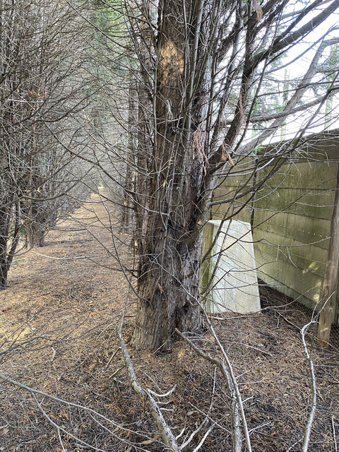
Babworth Images

Images are sourced within 2km of 53.322701/-0.978191 or Grid Reference SK6881. Thanks to Geograph Open Source API. All images are credited.

Chesterfield Canal & West Retford Lock
Cut Benchmark on 23 Cobwell Road See <a title="https://www.geograph.org.uk/photo/7171702" href="https://www.geograph.org.uk/photo/7171702">Link</a> for a view of the building, a former canal warehouse and <span class="nowrap"><a title="https://www.bench-marks.org.uk/bm70931" rel="nofollow ugc noopener" href="https://www.bench-marks.org.uk/bm70931">Link</a><img style="margin-left:2px;" alt="External link" title="External link - shift click to open in new window" src="https://s1.geograph.org.uk/img/external.png" width="10" height="10"/></span> for details of the mark.
Cut Benchmark on 23 Cobwell Road
See Link for a view of the building, a former canal warehouse and LinkExternal link for details of the mark.
Former Canal Warehouse in Cobwell Road This building carries a cut benchmark.  See <a title="https://www.geograph.org.uk/photo/7171695" href="https://www.geograph.org.uk/photo/7171695">Link</a> for a close-up and <span class="nowrap"><a title="https://www.bench-marks.org.uk/bm70931" rel="nofollow ugc noopener" href="https://www.bench-marks.org.uk/bm70931">Link</a><img style="margin-left:2px;" alt="External link" title="External link - shift click to open in new window" src="https://s1.geograph.org.uk/img/external.png" width="10" height="10"/></span> for details of the mark.
Former Canal Warehouse in Cobwell Road
This building carries a cut benchmark. See Link for a close-up and LinkExternal link for details of the mark.
Line off ECML
Line off ECML
Chesterfield Canal by Retford Cemetery
Forest Bottom Lock, Chesterfield Canal
Pond Farm Trig Point Flush Bracket S4896
Entrance to Works
Entrance to Works
Babworth Farm Trig Point Flush Bracket S4831
Ranby Trig Point Flush Bracket S1859
Lady Bridge over the Chesterfield Canal at Babworth This view of the eastern parapet shows well the extent of renewal in recent years, causing the loss of a benchmark on the roadside face of this parapet.
Lady Bridge over the Chesterfield Canal at Babworth
This view of the eastern parapet shows well the extent of renewal in recent years, causing the loss of a benchmark on the roadside face of this parapet.
Cut Mark on All Saints Church, Babworth Benchmark on corner buttress of Babworth church
Cut Mark on All Saints Church, Babworth
Benchmark on corner buttress of Babworth church
All Saints church, Babworth This church has association with Pilgrim Fathers and Scrooby
All Saints church, Babworth
This church has association with Pilgrim Fathers and Scrooby
Sports facilities, Retford
Sports pitch
Sports pitch
Field of brassicas
Field of brassicas
All Saints Church Babworth near Retford Notts The Parish church at Babworth is associated with Pilgrim Fathers (see the information board photograph).
All Saints Church Babworth near Retford Notts
The Parish church at Babworth is associated with Pilgrim Fathers (see the information board photograph).
Information Board Babworth Church
Show me another place!

Babworth is located at Grid Ref: SK6881 (Lat: 53.322701, Lng: -0.978191)

Administrative County: Nottinghamshire

District: Bassetlaw

Police Authority: Nottinghamshire

What 3 Words

///tenses.neater.microchip. Near Babworth, Nottinghamshire

Related Wikis

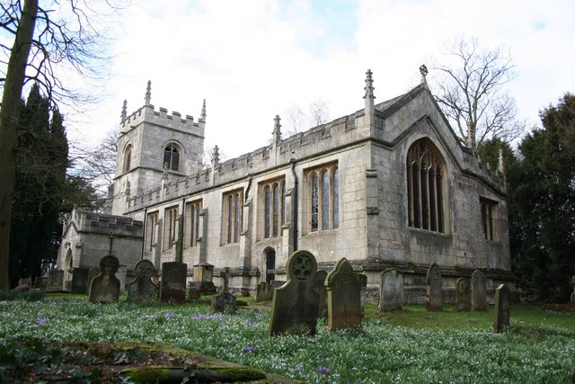
All Saints' Church, Babworth

All Saints' Church, is a Grade I listed parish church in the Church of England in Babworth, Nottinghamshire. == History == The church was built in the...

Ordsall Hall School

Ordsall Hall Comprehensive School was a comprehensive school situated on Ordsall Road in the market town of East Retford in the district of Bassetlaw,...

HM Prison Ranby

HM Prison Ranby is a Category C men's prison, located in the village of Ranby in Nottinghamshire, England. The prison is operated by His Majesty's Prison...

Retford F.C.

Retford Football Club is an English football club based in Retford, Nottinghamshire. They currently play in the Northern Counties East League Division...

Retford Oaks Academy

Retford Oaks Academy is a coeducational secondary school and sixth form located in the market town of Retford, Nottinghamshire, England, situated in the...

Babworth

Babworth is a village and civil parish in the Bassetlaw district of Nottinghamshire, England, about 1½ miles west of Retford. According to the 2001 census...

West Retford Hotel

West Retford Hotel in Nottinghamshire is a building of historical significance and is Grade II listed on the English Heritage Register. It was built in...

Idle Valley Nature Reserve

The Idle Valley Nature Reserve, also known as Lound Gravel Pits or Sutton and Lound Gravel Pits, is a wetland Site of Special Scientific Interest (SSSI...

Nearby Amenities

Located within 500m of 53.322701,-0.978191
Power: tower
Lat/Long: 53.3208028/-0.9827999
Power: pole
Lat/Long: 53.3196461/-0.9815242
Power: pole
Lat/Long: 53.3264707/-0.976701
Power: pole
Lat/Long: 53.3257051/-0.9776375
Power: pole
Lat/Long: 53.3249324/-0.9785864
Power: pole
Lat/Long: 53.3233823/-0.9804683
Power: pole
Lat/Long: 53.3241501/-0.9795192
Power: pole
Lat/Long: 53.3225778/-0.9806829
Power: pole
Lat/Long: 53.3217396/-0.9809501
Power: pole
Lat/Long: 53.320735/-0.9812078
Power: tower
Lat/Long: 53.325193/-0.9802406
Power: tower
Lat/Long: 53.3236339/-0.9826518
Babworth
Place: hamlet
Lat/Long: 53.3188387/-0.9767577
The data included in this document is from www.openstreetmap.org. The data is made available under ODbL.

Have you been to Babworth?

Leave your review of Babworth below (or comments, questions and feedback).