Gosberton Cheal

Settlement in Lincolnshire South Holland

England

Gosberton Cheal

Cressy Hall and Moated site near Gosberton: aerial 2021 See: <span class="nowrap"><a title="https://www.heritagegateway.org.uk/Gateway/Results_Single.aspx?uid=MLI86313&resourceID=1006" rel="nofollow ugc noopener" href="https://www.heritagegateway.org.uk/Gateway/Results_Single.aspx?uid=MLI86313&resourceID=1006">Link</a><img style="margin-left:2px;" alt="External link" title="External link - shift click to open in new window" src="https://s1.geograph.org.uk/img/external.png" width="10" height="10"/></span>
Cressy Hall and Moated site near Gosberton: aerial 2021 Credit: Simon Tomson

Gosberton Cheal is a small village located in the South Holland district of Lincolnshire, England. It is situated approximately 8 miles south-west of the town of Spalding and around 15 miles north-west of the city of Peterborough. With a population of just over 500 residents, it is a close-knit community that offers a peaceful and rural lifestyle.

The village is known for its picturesque countryside and beautiful landscapes. Surrounded by fertile agricultural land, Gosberton Cheal is primarily an agricultural village, with farming playing a significant role in its economy. The fields around the village are often filled with crops such as potatoes, vegetables, and cereals.

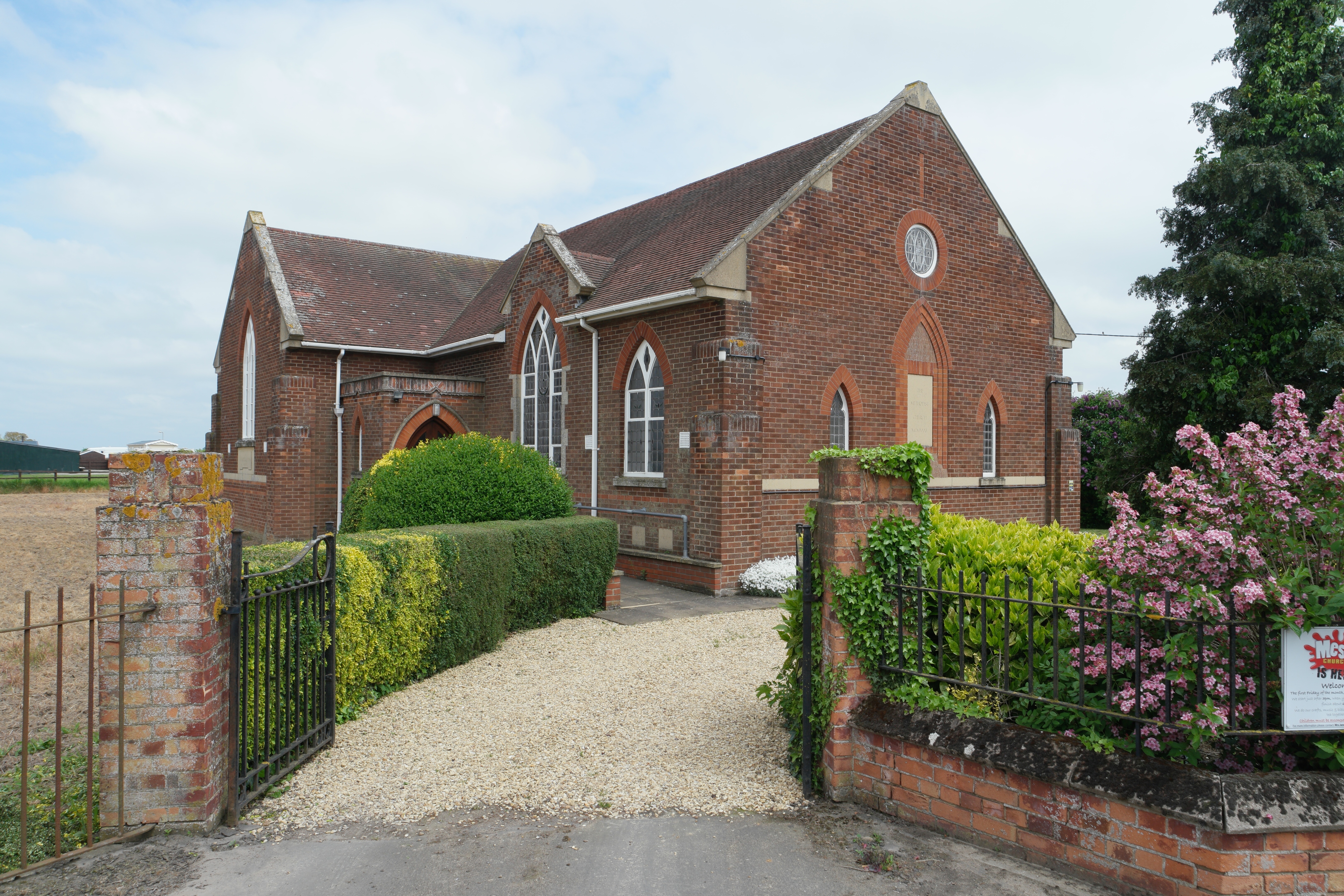
Despite its small size, Gosberton Cheal has a few amenities to offer its residents. These include a village hall, where local events and community gatherings take place, a primary school, and a small shop for basic necessities. The village is also home to the Church of St. Peter and St. Paul, a historic church dating back to the 13th century, which adds to the village's charm and heritage.

Gosberton Cheal benefits from its proximity to larger towns and cities, making it an ideal location for those seeking a quiet rural lifestyle while still having access to essential services. The village is well-connected to neighboring areas via road links, and public transportation options are available for those who commute to nearby towns for work or leisure activities.

In summary, Gosberton Cheal is a quaint and peaceful village in Lincolnshire, offering a countryside setting, agricultural heritage, and a close-knit community for its residents.

If you have any feedback on the listing, please let us know in the comments section below.

Gosberton Cheal Images

Images are sourced within 2km of 52.8432/-0.181 or Grid Reference TF2229. Thanks to Geograph Open Source API. All images are credited.

Cressy Hall and Moated site near Gosberton: aerial 2021 See: <span class="nowrap"><a title="https://www.heritagegateway.org.uk/Gateway/Results_Single.aspx?uid=MLI86313&resourceID=1006" rel="nofollow ugc noopener" href="https://www.heritagegateway.org.uk/Gateway/Results_Single.aspx?uid=MLI86313&resourceID=1006">Link</a><img style="margin-left:2px;" alt="External link" title="External link - shift click to open in new window" src="https://s1.geograph.org.uk/img/external.png" width="10" height="10"/></span>
Cressy Hall and Moated site near Gosberton: aerial 2021
See: LinkExternal link
Risegate Eau at Cressy Bridge Risegate Eau is completely blocked with vegetation.
Risegate Eau at Cressy Bridge
Risegate Eau is completely blocked with vegetation.
Sugar beet field off Station Road, Gosberton Risegate
Gosberton Railway Station Now closed but used as an industrial site
Gosberton Railway Station
Now closed but used as an industrial site
Crossing Gate Keeper's hut at Gosberton These railway gates are manually controlled, very quaint, but quite a few around these parts.
Crossing Gate Keeper's hut at Gosberton
These railway gates are manually controlled, very quaint, but quite a few around these parts.
Risegate Eau, Gosberton Wargate, Lincs flanked by the B1397 Station Road.
Risegate Eau, Gosberton Wargate, Lincs
flanked by the B1397 Station Road.
Windmill Lane
Windmill Lane
The Duke of York
The Duke of York
Entrance to Gosberton Risegate and Clough
Level Crossing
Level Crossing
Tree with eyes on it After driving past this spot I had to return after thinking this tree had winked at me.  Keek!
Tree with eyes on it
After driving past this spot I had to return after thinking this tree had winked at me. Keek!
Wargate Field Lane
Wargate Field Lane
Broccoli, as far as the eye can see 6 images of this field, stitched into a panorama. 

This is a typical fenland scene, with high-quality food crops stretching horizon to horizon.    Although sold in the UK as Broccoli, I know this as Calabrese, being the variety name.

See <a href="https://www.geograph.org.uk/photo/5609358">TF2130 : The Broccoli crop</a> for the crop, and <a href="https://www.geograph.org.uk/photo/5609359">TF2331 : The spire of Gosberton Church</a> for another detail.
Broccoli, as far as the eye can see
6 images of this field, stitched into a panorama. This is a typical fenland scene, with high-quality food crops stretching horizon to horizon. Although sold in the UK as Broccoli, I know this as Calabrese, being the variety name. See TF2130 : The Broccoli crop for the crop, and TF2331 : The spire of Gosberton Church for another detail.
The Broccoli crop The crop seen in <a href="https://www.geograph.org.uk/photo/5609356">TF2130 : Broccoli, as far as the eye can see</a>
The Broccoli crop
The bar at the Black Horse
The Restaurant at the Black Horse
The Black Horse A splendid pub and restaurant, well worth a visit
This also happens to be a consituent image of <a href="https://www.geograph.org.uk/photo/5609355">TF2129 : The tree in the Clough</a>
The Black Horse
A splendid pub and restaurant, well worth a visit This also happens to be a consituent image of TF2129 : The tree in the Clough
The Marjorum Hall There is an interesting tale about this place, which is owned by the Robert Marjorum Trust, and managed since 2011  by a village co-operative called the Marjorum Beehive Association (a beehive is a well-known symbol of the cooperative movement).

See <span class="nowrap"><a title="http://www.spaldingtoday.co.uk/news/success-for-village-hall-campaigners-1-2528238" rel="nofollow ugc noopener" href="http://www.spaldingtoday.co.uk/news/success-for-village-hall-campaigners-1-2528238">Link</a><img style="margin-left:2px;" alt="External link" title="External link - shift click to open in new window" src="https://s1.geograph.org.uk/img/external.png" width="10" height="10"/></span>
The Marjorum Hall
There is an interesting tale about this place, which is owned by the Robert Marjorum Trust, and managed since 2011 by a village co-operative called the Marjorum Beehive Association (a beehive is a well-known symbol of the cooperative movement). See LinkExternal link
Show me another place!

Gosberton Cheal is located at Grid Ref: TF2229 (Lat: 52.8432, Lng: -0.181)

Division: Parts of Holland

Administrative County: Lincolnshire

District: South Holland

Police Authority: Lincolnshire

What 3 Words

///alleyway.troll.spillage. Near Gosberton, Lincolnshire

Related Wikis

Gosberton railway station

Gosberton railway station was a station in Gosberton, Lincolnshire. It was opened in 1882 and closed for passengers on 11 September 1961 and freight on...

Risegate

Risegate is a village in the civil parish of Gosberton and the South Holland district of Lincolnshire, England. It is 30 miles (50 km) south-east from...

Gosberton

Gosberton is a village and civil parish in the South Holland district of Lincolnshire, England. It is situated 9 miles (14.5 km) south-west of Boston,...

Westhorpe, Lincolnshire

Westhorpe is a hamlet in the civil parish of Gosberton and the South Holland district of Lincolnshire, England. It is 30 miles (50 km) south-east from...

Surfleet

Surfleet is a small village and civil parish in the South Holland district of Lincolnshire, England. It is situated on the B1356 road, 3 miles (4.8 km...

Gosberton Clough

Gosberton Clough is a village in the civil parish of Gosberton and the South Holland district of Lincolnshire, England. It is 30 miles (50 km) south-east...

Belnie

Belnie is a hamlet in the civil parish of Gosberton, Lincolnshire, England. == References ==

Pinchbeck railway station

Pinchbeck railway station was a station in Pinchbeck, Lincolnshire, England on the line between Spalding and Sleaford. The station opened in 1882, closed...

Nearby Amenities

Located within 500m of 52.8432,-0.181
Water Drove
Crossing Barrier: full
Crossing Light: yes
Railway: level_crossing
Lat/Long: 52.8393026/-0.1795476
Cheal Road
Crossing Barrier: full
Crossing Light: yes
Railway: level_crossing
Lat/Long: 52.8430955/-0.1810797
Gosberton Cheal
Place: hamlet
Source: Bing
Lat/Long: 52.8438112/-0.1775769
Ebenezer House
Place: isolated_dwelling
Source: Bing
Lat/Long: 52.8440098/-0.1873095
Primrose House
Place: isolated_dwelling
Source: Bing
Lat/Long: 52.8427966/-0.1842811
Gatehouse
Place: isolated_dwelling
Source: Bing
Lat/Long: 52.8395617/-0.1794076
Water Drove
Crossing Barrier: full
Crossing Light: yes
Railway: level_crossing
Lat/Long: 52.8393087/-0.1795061
Cheal Road
Crossing Barrier: full
Crossing Light: yes
Railway: level_crossing
Lat/Long: 52.8431041/-0.181034
Elm Farm
Place: farm
Lat/Long: 52.8438129/-0.1769078
Railway: signal
Ref: WS7063
Lat/Long: 52.8389549/-0.179417
The data included in this document is from www.openstreetmap.org. The data is made available under ODbL.

Have you been to Gosberton Cheal?

Leave your review of Gosberton Cheal below (or comments, questions and feedback).