Brog an Eich
Coastal Feature, Headland, Point in Ross-shire
Scotland
Brog an Eich

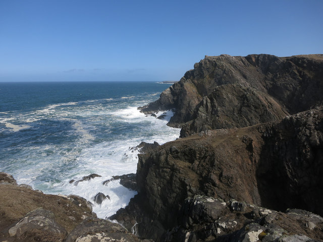
Brog an Eich is a prominent coastal feature located in Ross-shire, Scotland. It is classified as a headland or point due to its distinct geographical formation. Situated along the rugged coastline, it juts out into the North Sea, offering breathtaking views of the surrounding landscape.
The name "Brog an Eich" is derived from the Scottish Gaelic language and translates to "the horse's brow" in English. This name is fitting, as the headland's shape resembles the brow of a horse when viewed from a distance. It is a unique and recognizable landmark in the region.
The headland is characterized by its sheer cliffs, which reach impressive heights above the crashing waves below. The rock formations are composed of sedimentary layers, showcasing millions of years of geological history. Visitors can observe various fossils embedded within the rocks, evidence of the area's ancient marine life.
Brog an Eich is a haven for wildlife enthusiasts, as it provides a habitat for numerous seabirds, such as gannets, puffins, and guillemots. The headland's location also makes it an ideal spot for observing migratory birds during certain times of the year.
The headland offers several walking trails for visitors to explore, providing access to stunning views of the surrounding coastline and the nearby sea stacks. These trails also lead to hidden coves and secluded beaches, adding to the allure of the area.
Brog an Eich is a significant landmark in Ross-shire, attracting both locals and tourists alike. Its rugged beauty, unique rock formations, and abundant wildlife make it a must-visit destination for nature enthusiasts and those seeking an escape into Scotland's natural wonders.
If you have any feedback on the listing, please let us know in the comments section below.
Brog an Eich Images
Images are sourced within 2km of 58.301942/-6.8029 or Grid Reference NB1844. Thanks to Geograph Open Source API. All images are credited.


Brog an Eich is located at Grid Ref: NB1844 (Lat: 58.301942, Lng: -6.8029)
Unitary Authority: Na h-Eileanan an Iar
Police Authority: Highlands and Islands
What 3 Words
///chambers.surface.assembles. Near Carloway, Na h-Eileanan Siar
Related Wikis

Garenin
Garenin (Scottish Gaelic: Na Gearrannan) is a crofting township on the west coast of the Isle of Lewis in the Outer Hebrides of Scotland. Garenin is in...

Borrowston, Lewis
Borrowston (Scottish Gaelic: Borghastan), with a population of about 50, is a crofting township situated on the Isle of Lewis, on the Outer Hebrides of...

Carloway
Carloway (Scottish Gaelic: Càrlabhagh [ˈkʰaːɾɫ̪ə.ɤː]) is a crofting township and a district on the west coast of the Isle of Lewis, in the Outer Hebrides...

Dun Carloway
Dun Carloway (Scottish Gaelic: Dùn Chàrlabhaigh) is a broch situated in the district of Carloway, on the west coast of the Isle of Lewis, Scotland (grid...

Siadar Wave Power Station
The Siadar Wave Power Station (also known as Siadar Wave Energy Project or SWEP) was a proposed 4 MW wave farm 400 metres (1,300 ft) off the shore of Siadar...

Campaigh
Campaigh or Campay is a steep and rocky islet in outer Loch Ròg, Lewis, Scotland that lies north of Cealasaigh and Little Bernera. A huge natural arch...
Cealasaigh
Cealasaigh or Kealasay is an islet in outer Loch Ròg, Lewis, Scotland that lies north of Traigh Mhór on Little Bernera and south of Campaigh. To the west...

Little Bernera
Little Bernera (Scottish Gaelic: Beàrnaraigh Beag) is a small island situated off the west coast of the Isle of Lewis in the Outer Hebrides.Little Bernera...
Have you been to Brog an Eich?
Leave your review of Brog an Eich below (or comments, questions and feedback).