A' Bheirigh

Coastal Feature, Headland, Point in Ross-shire

Scotland

A' Bheirigh

Blackhouse Village at Garenin
Blackhouse Village at Garenin Credit: Colin Park

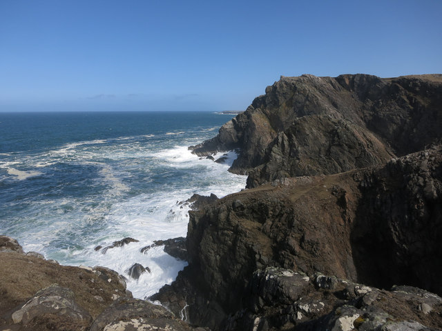
A' Bheirigh is a prominent coastal feature located in Ross-shire, Scotland. It is a headland that juts out into the North Atlantic Ocean, forming a distinct point along the rugged coastline. With its stunning natural beauty and unique geological formations, A' Bheirigh attracts visitors from all over the world.

The headland is characterized by towering cliffs that stretch high above the crashing waves below. These cliffs are composed of ancient rocks, showcasing layers of sedimentary formations that have been shaped by millions of years of erosion. The exposed rock faces offer a glimpse into the area's geological history, with fossils and other evidence of ancient marine life often preserved in the layers.

A' Bheirigh is also home to a diverse range of flora and fauna. The headland's exposed location and nutrient-rich waters attract a variety of seabirds, including puffins, gannets, and fulmars. Visitors can often spot these majestic creatures soaring above or nesting in the cliffs. The surrounding waters are also teeming with marine life, with seals, dolphins, and even the occasional whale making appearances.

In addition to its natural beauty, A' Bheirigh offers stunning views of the surrounding landscape. On a clear day, visitors can see the distant mountains of the Scottish Highlands to the east and the vast expanse of the Atlantic Ocean to the west. The headland's rugged terrain and dramatic vistas provide a perfect backdrop for hiking, photography, and simply enjoying the tranquility of nature.

Overall, A' Bheirigh is a remarkable coastal feature that showcases the raw power and beauty of Scotland's coastline. Its geological significance, diverse wildlife, and breathtaking scenery make it a must-visit destination for nature enthusiasts and outdoor adventurers alike.

If you have any feedback on the listing, please let us know in the comments section below.

A' Bheirigh Images

Images are sourced within 2km of 58.303414/-6.8034588 or Grid Reference NB1845. Thanks to Geograph Open Source API. All images are credited.

Blackhouse Village at Garenin
Ruin by Loch Garenin
Bus shelter near the Tweed Mill
Na Gearrannan The main road through the restored part of the old village of blackhouses. People lived in some of these houses up until 1974.
Na Gearrannan
The main road through the restored part of the old village of blackhouses. People lived in some of these houses up until 1974.
Buildings in Gearrannan Blackhouse Village
Loch Garenin Sea loch below the Black House Village.
Loch Garenin
Sea loch below the Black House Village.
Blackhouse Village at Garenin The village was occupied until 1974. Restored in the later years of the Century. The plaque commemorates the opening of the village as a visitor attraction by Princess Anne. Most of the black houses are let as self-catering holiday accommodation.
Blackhouse Village at Garenin
The village was occupied until 1974. Restored in the later years of the Century. The plaque commemorates the opening of the village as a visitor attraction by Princess Anne. Most of the black houses are let as self-catering holiday accommodation.
Cottage interior, Garenin Blackhouse Village
Garenin Blackhouses Museum Group of reconstructed blackhouses which give an excellent impression of what Hebridean hamlets would have looked like 200 years ago.
Garenin Blackhouses Museum
Group of reconstructed blackhouses which give an excellent impression of what Hebridean hamlets would have looked like 200 years ago.
Garenin Blackhouses Museum A reconstructed blackhouse settlement.
Garenin Blackhouses Museum
A reconstructed blackhouse settlement.
Rubha Mor Neidallt illicit still Illicit still hidden below a large rock outcrop. <span class="nowrap"><a title="https://canmore.org.uk/site/137120/lewis-rubha-mor-neidallt" rel="nofollow ugc noopener" href="https://canmore.org.uk/site/137120/lewis-rubha-mor-neidallt">Link</a><img style="margin-left:2px;" alt="External link" title="External link - shift click to open in new window" src="https://s1.geograph.org.uk/img/external.png" width="10" height="10"/></span>
Rubha Mor Neidallt illicit still
Illicit still hidden below a large rock outcrop. LinkExternal link
Rubha Mor Neidallt illicit still View into the building from the rock outcrop above the building. <span class="nowrap"><a title="https://canmore.org.uk/site/137120/lewis-rubha-mor-neidallt" rel="nofollow ugc noopener" href="https://canmore.org.uk/site/137120/lewis-rubha-mor-neidallt">Link</a><img style="margin-left:2px;" alt="External link" title="External link - shift click to open in new window" src="https://s1.geograph.org.uk/img/external.png" width="10" height="10"/></span>
Rubha Mor Neidallt illicit still
View into the building from the rock outcrop above the building. LinkExternal link
Marker Cairn
Marker Cairn
Aird Mheadhonach cliffs, sheepfold and lazy beds
Historic shelter or shieling
Àird a' Ghobhann Looking along the extremely exposed west coast of Lewis.
Àird a' Ghobhann
Looking along the extremely exposed west coast of Lewis.
Carloway Mill
Carloway Mill
Show me another place!

A' Bheirigh is located at Grid Ref: NB1845 (Lat: 58.303414, Lng: -6.8034588)

Unitary Authority: Na h-Eileanan an Iar

Police Authority: Highlands and Islands

What 3 Words

///fools.simulations.rates. Near Carloway, Na h-Eileanan Siar

Related Wikis

Have you been to A' Bheirigh?

Leave your review of A' Bheirigh below (or comments, questions and feedback).