Green Covert

Wood, Forest in Suffolk East Suffolk

England

Green Covert

Cartshed, past the best
Cartshed, past the best Credit: Adrian S Pye

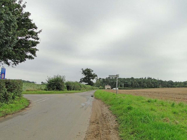
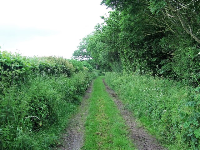
Green Covert is a picturesque woodland located in the county of Suffolk, England. Situated in the heart of the county, it covers an area of approximately 100 acres and is known for its abundant greenery and diverse wildlife. The woodland is part of a larger forested area and is surrounded by rolling hills and meadows.

The trees that dominate Green Covert include oak, beech, and birch, standing tall and providing a dense canopy that allows only dappled sunlight to filter through. The forest floor is carpeted with a variety of wildflowers, ferns, and mosses, creating a vibrant and colorful undergrowth. Several walking trails wind through the woodland, allowing visitors to explore its beauty and immerse themselves in nature.

The woodland is home to a wide range of wildlife species. Various bird species can be spotted, including woodpeckers, owls, and songbirds, filling the air with their melodious calls. Small mammals such as squirrels and rabbits are also commonly seen darting through the trees. Additionally, Green Covert is known for its diverse insect population, with butterflies, bees, and beetles adding to the biodiversity of the area.

Green Covert is a popular destination for nature enthusiasts, hikers, and photographers. Its peaceful and serene atmosphere provides an ideal escape from the hustle and bustle of everyday life. Whether visitors are looking for a leisurely stroll, a picnic spot, or wildlife spotting, Green Covert offers a tranquil and idyllic setting to reconnect with nature.

If you have any feedback on the listing, please let us know in the comments section below.

Green Covert Images

Images are sourced within 2km of 52.145046/1.4157625 or Grid Reference TM3355. Thanks to Geograph Open Source API. All images are credited.

Cartshed, past the best
Road junction to Campsea Ashe on Ash Road
Grazing near Ashe Abbey
Field Cottage Set in farmland near Jolly's Farm.
Field Cottage
Set in farmland near Jolly's Farm.
Farmland towards Allonsfield
Field, Campsea Ashe Looking towards the church.
Field, Campsea Ashe
Looking towards the church.
The Blaxhall Stone A nearby information sign <a href="https://www.geograph.org.uk/photo/4297025">TM3556 : Information Sign</a> reads "Said to have been ploughed up in the 19th century when no bigger than two fists, thrown down by the ploughman where it now stands, it has been growing ever since". According to <span class="nowrap"><a title="http://www.megalithia.com/sites/tm351565.html" rel="nofollow ugc noopener" href="http://www.megalithia.com/sites/tm351565.html">Link</a><img style="margin-left:2px;" alt="External link" title="External link - shift click to open in new window" src="https://s1.geograph.org.uk/img/external.png" width="10" height="10"/></span> this glacial erratic weighs five tons and comes from a parent mass in Spilsby, Lincolnshire.
The Blaxhall Stone
A nearby information sign TM3556 : Information Sign reads "Said to have been ploughed up in the 19th century when no bigger than two fists, thrown down by the ploughman where it now stands, it has been growing ever since". According to LinkExternal link this glacial erratic weighs five tons and comes from a parent mass in Spilsby, Lincolnshire.
Blackstock Barn, Stone Farm, Blaxhall
Thatched cottages
Thatched cottages
Interior of St John the Baptist's Church The 14th-century nave and chancel were rebuilt in 1792 and further restored in 1869.  The chancel arch and ceiling date from the 19th-century restoration.  The communion table of 1936 was designed by the noted Suffolk ecclesiologist Henry Munro Cautley.  The east window showing Christ in majesty <a href="https://www.geograph.org.uk/photo/2012442">TM3255 : Campsea Ashe, St John the Baptist: stained glass window (3)</a> is the work of Powell & Sons in 1912 as a memorial to William and Alice Lowther.  <span class="nowrap"><a title="http://www.suffolkchurches.co.uk/campsea.html" rel="nofollow ugc noopener" href="http://www.suffolkchurches.co.uk/campsea.html">Link</a><img style="margin-left:2px;" alt="External link" title="External link - shift click to open in new window" src="https://s1.geograph.org.uk/img/external.png" width="10" height="10"/></span>
Interior of St John the Baptist's Church
The 14th-century nave and chancel were rebuilt in 1792 and further restored in 1869. The chancel arch and ceiling date from the 19th-century restoration. The communion table of 1936 was designed by the noted Suffolk ecclesiologist Henry Munro Cautley. The east window showing Christ in majesty TM3255 : Campsea Ashe, St John the Baptist: stained glass window (3) is the work of Powell & Sons in 1912 as a memorial to William and Alice Lowther. LinkExternal link
Faith and Hope - two theological virtues Pre-Raphaelite stained glass of 1882 in St John the Baptist's Church, designed by Sir Henry Holiday for Powell Brothers as a memorial to John George Sheppard.  Faith is represented by the Cross, and Hope by an anchor.  In the vine-leaf panels above, doves symbolising the Holy Spirit are seen ascending at the left and descending on the right.  For a general view of the window see <a href="https://www.geograph.org.uk/photo/2012477">TM3255 : Campsea Ashe, St John the Baptist: stained glass window (5)</a>.
Faith and Hope - two theological virtues
Pre-Raphaelite stained glass of 1882 in St John the Baptist's Church, designed by Sir Henry Holiday for Powell Brothers as a memorial to John George Sheppard. Faith is represented by the Cross, and Hope by an anchor. In the vine-leaf panels above, doves symbolising the Holy Spirit are seen ascending at the left and descending on the right. For a general view of the window see TM3255 : Campsea Ashe, St John the Baptist: stained glass window (5).
Pelican in her Piety Stained glass of 1880 in St John the Baptist's Church; detail of a memorial window to Egidia, 5th Baroness Rendlesham.  The companion left-hand panel shows the Agnus Dei.  For the whole window see <a href="https://www.geograph.org.uk/photo/2012430">TM3255 : Campsea Ashe, St John the Baptist: stained glass window (1)</a>.
Pelican in her Piety
Stained glass of 1880 in St John the Baptist's Church; detail of a memorial window to Egidia, 5th Baroness Rendlesham. The companion left-hand panel shows the Agnus Dei. For the whole window see TM3255 : Campsea Ashe, St John the Baptist: stained glass window (1).
Footpath Footpath looking east near to Campsea Ashe, Suffolk.
Footpath
Footpath looking east near to Campsea Ashe, Suffolk.
Walnut Tree Avenue Walnut Tree Avenue Rendlesham, Suffolk.
Walnut Tree Avenue
Walnut Tree Avenue Rendlesham, Suffolk.
Garden Square Looking along Garden Square Rendlesham, Suffolk.
Garden Square
Looking along Garden Square Rendlesham, Suffolk.
Cut Mark Campsey Ashe Church Cut Mark Campsey Ashe St John the Baptist Church SE angle, SE face.
Cut Mark Campsey Ashe Church
Cut Mark Campsey Ashe St John the Baptist Church SE angle, SE face.
Campsea Ashe War Memorial Campsea Ashe War Memorial for the Great War bears 17 names. Their details and those from WW2 can be seen here: <span class="nowrap"><a title="http://media.geograph.org.uk/files/fe9fc289c3ff0af142b6d3bead98a923/CAMPSEA_ASHE_War_Memorial.pdf" rel="nofollow ugc noopener" href="http://media.geograph.org.uk/files/fe9fc289c3ff0af142b6d3bead98a923/CAMPSEA_ASHE_War_Memorial.pdf">Link</a><img style="margin-left:2px;" alt="External link" title="External link - shift click to open in new window" src="https://s1.geograph.org.uk/img/external.png" width="10" height="10"/></span>
Campsea Ashe War Memorial
Campsea Ashe War Memorial for the Great War bears 17 names. Their details and those from WW2 can be seen here: LinkExternal link
Campsea Ashe War Memorial The Campsea Ashe War Memorial for WW2 has six names but an additional name was appended on a small tablet for William Newman who died of wounds in 1951.
Details of the village's First and Second World War losses can be seen here: <span class="nowrap"><a title="http://media.geograph.org.uk/files/fe9fc289c3ff0af142b6d3bead98a923/CAMPSEA_ASHE_War_Memorial.pdf" rel="nofollow ugc noopener" href="http://media.geograph.org.uk/files/fe9fc289c3ff0af142b6d3bead98a923/CAMPSEA_ASHE_War_Memorial.pdf">Link</a><img style="margin-left:2px;" alt="External link" title="External link - shift click to open in new window" src="https://s1.geograph.org.uk/img/external.png" width="10" height="10"/></span>
Campsea Ashe War Memorial
The Campsea Ashe War Memorial for WW2 has six names but an additional name was appended on a small tablet for William Newman who died of wounds in 1951. Details of the village's First and Second World War losses can be seen here: LinkExternal link
Show me another place!

Green Covert is located at Grid Ref: TM3355 (Lat: 52.145046, Lng: 1.4157625)

Administrative County: Suffolk

District: East Suffolk

Police Authority: Suffolk

What 3 Words

///captions.flow.nickname. Near Rendlesham, Suffolk

Related Wikis

Campsea Ashe

Campsea Ashe (sometimes spelt Campsey Ash) is a village in Suffolk, England located approximately 5 miles (8 km) north east of Woodbridge and 6 miles...

Rendlesham Hall

Rendlesham Hall was a large manor house in the village of Rendlesham in Suffolk. == History == The hall was built in the pointed style in 1780 and two...

Wickham Market railway station

Wickham Market railway station is on the East Suffolk Line in the east of England, located in Campsea Ashe, Suffolk, approximately 2 miles (3.2 km) east...

Rendlesham

Rendlesham is a village and civil parish near Woodbridge, Suffolk, United Kingdom. It was a royal centre of authority for the king of the East Angles....

Campsey Priory

Campsey Priory, (Campesse, Kampessie, etc.), was a religious house of Augustinian canonesses at Campsea Ashe, Suffolk, about 1.5 miles (2.5 km) south east...

RAF Bentwaters

Royal Air Force Bentwaters or more simply RAF Bentwaters, now known as Bentwaters Parks, is a former Royal Air Force station about 80 miles (130 km) northeast...

Tunstall, Suffolk

On an Ordnance Survey map of Suffolk, England, there are two settlements named Tunstall next to each other, 7.5 miles (12.1 km) north east of Woodbridge...

Marlesford

Marlesford is a village and civil parish in the East Suffolk district of Suffolk, England. The population of the civil parish at the 2011 Census was 233...

Nearby Amenities

Located within 500m of 52.145046,1.4157625
Post Box
Collection Times: Mo-Fr 09:00; Sa 08:45
Post Box Type: lamp
Ref: IP13 6367
Royal Cypher: EIIR
Royal Cypher Wikidata: Q33102113
Lat/Long: 52.1447167/1.4166704
The data included in this document is from www.openstreetmap.org. The data is made available under ODbL.

Have you been to Green Covert?

Leave your review of Green Covert below (or comments, questions and feedback).