Bracondale Grove

Wood, Forest in Norfolk Norwich

England

Bracondale Grove

View of City Wall, King Street, Norwich A view along the outside edge of the City Wall heading north from King Street up towards the Black Tower at the top of the hill. During the 19th century there were houses abutting right up onto the wall as can be evidenced by the beams seen here.
View of City Wall, King Street, Norwich Credit: Adam Smith

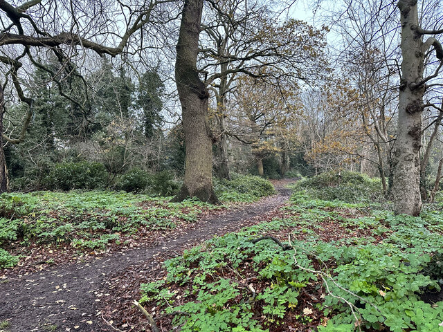
Bracondale Grove, located in Norfolk, is a picturesque woodland area renowned for its natural beauty and tranquil atmosphere. Nestled amidst the rolling hills and meandering rivers of the county, this forested haven offers a serene retreat for nature enthusiasts and outdoor adventurers.

Covering an expansive area of lush greenery, Bracondale Grove is home to a diverse range of flora and fauna. Towering oak, beech, and birch trees dominate the landscape, their dense canopies providing ample shade during summer months. The forest floor is carpeted with an array of wildflowers, creating a vibrant tapestry of colors.

The grove is crisscrossed by a network of well-maintained walking trails, allowing visitors to explore its enchanting surroundings. Nature lovers can spot a variety of wildlife here, including deer, rabbits, squirrels, and a wide array of bird species. The babbling brooks and glistening ponds within the grove also attract amphibious creatures like frogs and newts.

Bracondale Grove is not only a haven for wildlife but also a popular destination for outdoor activities. The trails cater to hikers, joggers, and cyclists, offering a chance to immerse oneself in the great outdoors. Additionally, the grove is equipped with picnic areas, allowing families and friends to enjoy a leisurely day out amidst nature.

With its idyllic setting and abundance of natural wonders, Bracondale Grove is a true gem of Norfolk. Whether it be for a peaceful stroll, a wildlife encounter, or simply a moment of respite in the embrace of nature, this forested haven has something to offer for everyone seeking solace in the great outdoors.

If you have any feedback on the listing, please let us know in the comments section below.

Bracondale Grove Images

Images are sourced within 2km of 52.618593/1.3067212 or Grid Reference TG2307. Thanks to Geograph Open Source API. All images are credited.

View of City Wall, King Street, Norwich A view along the outside edge of the City Wall heading north from King Street up towards the Black Tower at the top of the hill. During the 19th century there were houses abutting right up onto the wall as can be evidenced by the beams seen here.
View of City Wall, King Street, Norwich
A view along the outside edge of the City Wall heading north from King Street up towards the Black Tower at the top of the hill. During the 19th century there were houses abutting right up onto the wall as can be evidenced by the beams seen here.
View down King Street, Norwich A rainy view down King Street, looking north from the junction with Rouen Road. The entrance to the Wensum Sports Centre can be seen on the right followed by the Music House.
View down King Street, Norwich
A rainy view down King Street, looking north from the junction with Rouen Road. The entrance to the Wensum Sports Centre can be seen on the right followed by the Music House.
The Music House, King Street, Norwich The Music House is the oldest dwelling house in Norwich. From c.1170 - 1240 it was home to the Jewish family the Jurnets then Sir John Paston lived here from 1478 and Lord Chief Justice Coke from 1613.

<span class="nowrap"><a title="https://www.heritage.norfolk.gov.uk/record-details?MNF604-Wensum-Lodge-or-The-Music-House-Nos-167-and-169-King-Street" rel="nofollow ugc noopener" href="https://www.heritage.norfolk.gov.uk/record-details?MNF604-Wensum-Lodge-or-The-Music-House-Nos-167-and-169-King-Street">Link</a><img style="margin-left:2px;" alt="External link" title="External link - shift click to open in new window" src="https://s1.geograph.org.uk/img/external.png" width="10" height="10"/></span>
The Music House, King Street, Norwich
The Music House is the oldest dwelling house in Norwich. From c.1170 - 1240 it was home to the Jewish family the Jurnets then Sir John Paston lived here from 1478 and Lord Chief Justice Coke from 1613. LinkExternal link
St Peter Parmentergate Church from King Street, Norwich A view of the rear of St Peter Parmentergate Church from King Street in Norwich. One of the city's many fine medieval churches and home to a very strongly Anglo-Catholic congregation until it fell into disuse. It now houses a skate shop.

<span class="nowrap"><a title="http://www.norfolkchurches.co.uk/norwichpeterparmentergate/norwichpeterparmentergate.htm" rel="nofollow ugc noopener" href="http://www.norfolkchurches.co.uk/norwichpeterparmentergate/norwichpeterparmentergate.htm">Link</a><img style="margin-left:2px;" alt="External link" title="External link - shift click to open in new window" src="https://s1.geograph.org.uk/img/external.png" width="10" height="10"/></span>
St Peter Parmentergate Church from King Street, Norwich
A view of the rear of St Peter Parmentergate Church from King Street in Norwich. One of the city's many fine medieval churches and home to a very strongly Anglo-Catholic congregation until it fell into disuse. It now houses a skate shop. LinkExternal link
74A King Street, Norwich A rather handsome, if squat, house with a courtyard at the rear. This part of King Street was once famous for its many public houses, this house was, at one time, surrounded on all sides by the Nelson Monument, the Three Tuns, the Boilermakers Arms and the Bird in Hand.
74A King Street, Norwich
A rather handsome, if squat, house with a courtyard at the rear. This part of King Street was once famous for its many public houses, this house was, at one time, surrounded on all sides by the Nelson Monument, the Three Tuns, the Boilermakers Arms and the Bird in Hand.
Tombland, Norwich A view of Tombland on an exceptionally wet December morning. The Cathedral can be seen in the distance. 

The obelisk is a memorial to machinery which stood on this site between 1700 and 1830 which raised and stored water for the higher parts of the city. In 1860, a drinking fountain was erected here to commemorate this by John Henry Gurney.

<span class="nowrap"><a title="https://artuk.org/discover/artworks/gurney-drinking-fountain-and-obelisk-313011" rel="nofollow ugc noopener" href="https://artuk.org/discover/artworks/gurney-drinking-fountain-and-obelisk-313011">Link</a><img style="margin-left:2px;" alt="External link" title="External link - shift click to open in new window" src="https://s1.geograph.org.uk/img/external.png" width="10" height="10"/></span>
Tombland, Norwich
A view of Tombland on an exceptionally wet December morning. The Cathedral can be seen in the distance. The obelisk is a memorial to machinery which stood on this site between 1700 and 1830 which raised and stored water for the higher parts of the city. In 1860, a drinking fountain was erected here to commemorate this by John Henry Gurney. LinkExternal link
Former Quayside School, Norwich A quite unusual example of Victorian architecture - this is the former girls and infants section of Quayside School at the bottom of Piggs Lane, Norwich.
Former Quayside School, Norwich
A quite unusual example of Victorian architecture - this is the former girls and infants section of Quayside School at the bottom of Piggs Lane, Norwich.
View along Quayside, Norwich The view along Quayside, Norwich looking towards Fye Bridge on a very rainy December morning. A double decker bus crosses over the bridge heading into the city centre.
View along Quayside, Norwich
The view along Quayside, Norwich looking towards Fye Bridge on a very rainy December morning. A double decker bus crosses over the bridge heading into the city centre.
Looking up Golden Dog Lane, Norwich The view up Golden Dog Lane, Norwich as seen from Magdalen Street. The building on the right was once the Golden Dog PH but is now a barbershop. At one time the Golden Dog had not only a bar but also a very small brewery on site. 

<span class="nowrap"><a title="https://www.norfolkpubs.co.uk/norwich/gnorwich/ncgld.htm" rel="nofollow ugc noopener" href="https://www.norfolkpubs.co.uk/norwich/gnorwich/ncgld.htm">Link</a><img style="margin-left:2px;" alt="External link" title="External link - shift click to open in new window" src="https://s1.geograph.org.uk/img/external.png" width="10" height="10"/></span>
Looking up Golden Dog Lane, Norwich
The view up Golden Dog Lane, Norwich as seen from Magdalen Street. The building on the right was once the Golden Dog PH but is now a barbershop. At one time the Golden Dog had not only a bar but also a very small brewery on site. LinkExternal link
John Lewis in Norwich (Formerly Bonds)
St John the Baptist church in Norwich
Jubilee Park, Norwich A view into Jubilee Park in Lakenham, Norwich. The rather lovely, mature tree that stands at the entrance to the park is bare as winter has truly set in here. The Jubilee Community Centre can be seen in the distance.
Jubilee Park, Norwich
A view into Jubilee Park in Lakenham, Norwich. The rather lovely, mature tree that stands at the entrance to the park is bare as winter has truly set in here. The Jubilee Community Centre can be seen in the distance.
Long John's Hill, Norwich Looking up into the woodland that sits behind County Hall in Lakenham, Norwich. The old OS Maps for this area have Knucklebone Hall sitting on this strip of woodland but no trace of it seems to remain. The road nearby is called Long John's Hill but I think that this area of woods that rises up behind Martineau Lane can also be called that.
Long John's Hill, Norwich
Looking up into the woodland that sits behind County Hall in Lakenham, Norwich. The old OS Maps for this area have Knucklebone Hall sitting on this strip of woodland but no trace of it seems to remain. The road nearby is called Long John's Hill but I think that this area of woods that rises up behind Martineau Lane can also be called that.
Long John's Hill, Lakenham, Norwich Looking down Long John's Hill with Suncroft heading off to the left. The slightly bleak winter weather contrasts with the name of the street.
Long John's Hill, Lakenham, Norwich
Looking down Long John's Hill with Suncroft heading off to the left. The slightly bleak winter weather contrasts with the name of the street.
Lakenham Community Offices, Norwich A view of the Lakenham Community Office at the top of Mansfield Lane. It's not clear how well used the building is, Norwich City Council stopped the drop-in service a few years ago and the car park never appears to be open.
Lakenham Community Offices, Norwich
A view of the Lakenham Community Office at the top of Mansfield Lane. It's not clear how well used the building is, Norwich City Council stopped the drop-in service a few years ago and the car park never appears to be open.
The Lakenham Way, Norwich Looking north from the Hall Road at The Lakenham Way, a footpath that runs along the old Great Eastern Railway from Victoria Station to its junction with the GER Loop Line. This line is labelled on an early C20 OS Map as the 'Eastern Union Line' after the Eastern Union Railway who originally built the Norwich - London mainline.
The Lakenham Way, Norwich
Looking north from the Hall Road at The Lakenham Way, a footpath that runs along the old Great Eastern Railway from Victoria Station to its junction with the GER Loop Line. This line is labelled on an early C20 OS Map as the 'Eastern Union Line' after the Eastern Union Railway who originally built the Norwich - London mainline.
Dinosaur on Lower Court, Norwich Cathedral The GoGoDiscover city trail of dinosaur sculptures. It is hoped it will raise money for Break, a charity supporting children and young people in care. The pieces are sponsored by businesses and painted by local artists. The 21 dinosaurs are in various locations including the cathedral, Riverside and shopping areas.
Dinosaur on Lower Court, Norwich Cathedral
The GoGoDiscover city trail of dinosaur sculptures. It is hoped it will raise money for Break, a charity supporting children and young people in care. The pieces are sponsored by businesses and painted by local artists. The 21 dinosaurs are in various locations including the cathedral, Riverside and shopping areas.
Dinosaur on London Street, Norwich The GoGoDiscover city dinosaur trail hopes to raise money for Break, a charity supporting children and young people in care. The 21 pieces are sponsored by businesses and painted by local artists. The dinosaurs are in various locations including the cathedral, Riverside and shopping areas.
Dinosaur on London Street, Norwich
The GoGoDiscover city dinosaur trail hopes to raise money for Break, a charity supporting children and young people in care. The 21 pieces are sponsored by businesses and painted by local artists. The dinosaurs are in various locations including the cathedral, Riverside and shopping areas.
Show me another place!

Bracondale Grove is located at Grid Ref: TG2307 (Lat: 52.618593, Lng: 1.3067212)

Administrative County: Norfolk

District: Norwich

Police Authority: Norfolk

What 3 Words

///upper.they.farmer. Near Thorpe Hamlet, Norfolk

Related Wikis

Bracondale School

Bracondale School was a private boys' school in the Bracondale area of Norwich, Norfolk. It existed from 1821 to 1993. == History == The school was opened...

Carrow Abbey

Carrow Abbey is a former Benedictine priory in Bracondale, southeast Norwich, England. The village on the site used to be called Carrow (there are many...

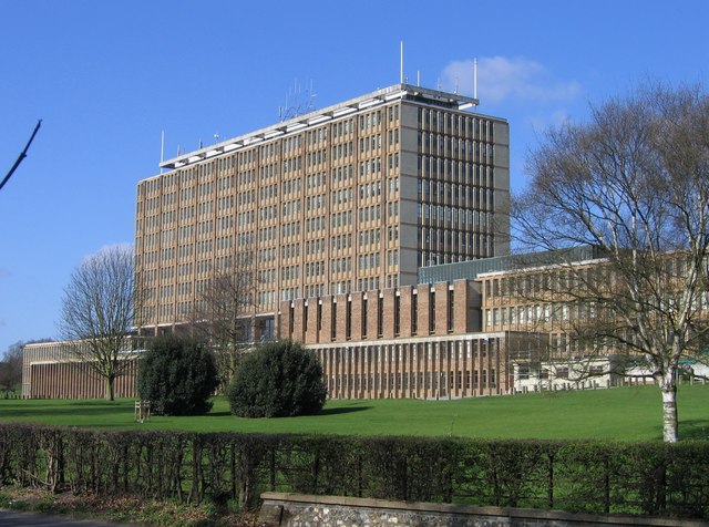
County Hall, Norwich

County Hall is a municipal facility at Martineau Lane in Norwich, Norfolk. It is the headquarters of Norfolk County Council. == History == For much of...

Carrow Road

Carrow Road is a football stadium in Norwich, Norfolk, England, and is the home of EFL Championship side Norwich City. The stadium is east of the city...

Argyle Street, Norwich

Argyle Street was a Victorian terraced street in Norwich, Norfolk. It became a squat lasting from 1979 to 1985. The street was then demolished in 1986...

County Ground, Lakenham

The County Ground in Lakenham, Norwich, Norfolk was a cricket ground for over two hundred years, hosting both first-class and List A cricket. Five first...

Norfolk Record Office

The Norfolk Record Office holds the archives for the County of Norfolk. The archives are held at Martineau Lane, Norwich, and run by Norfolk County Council...
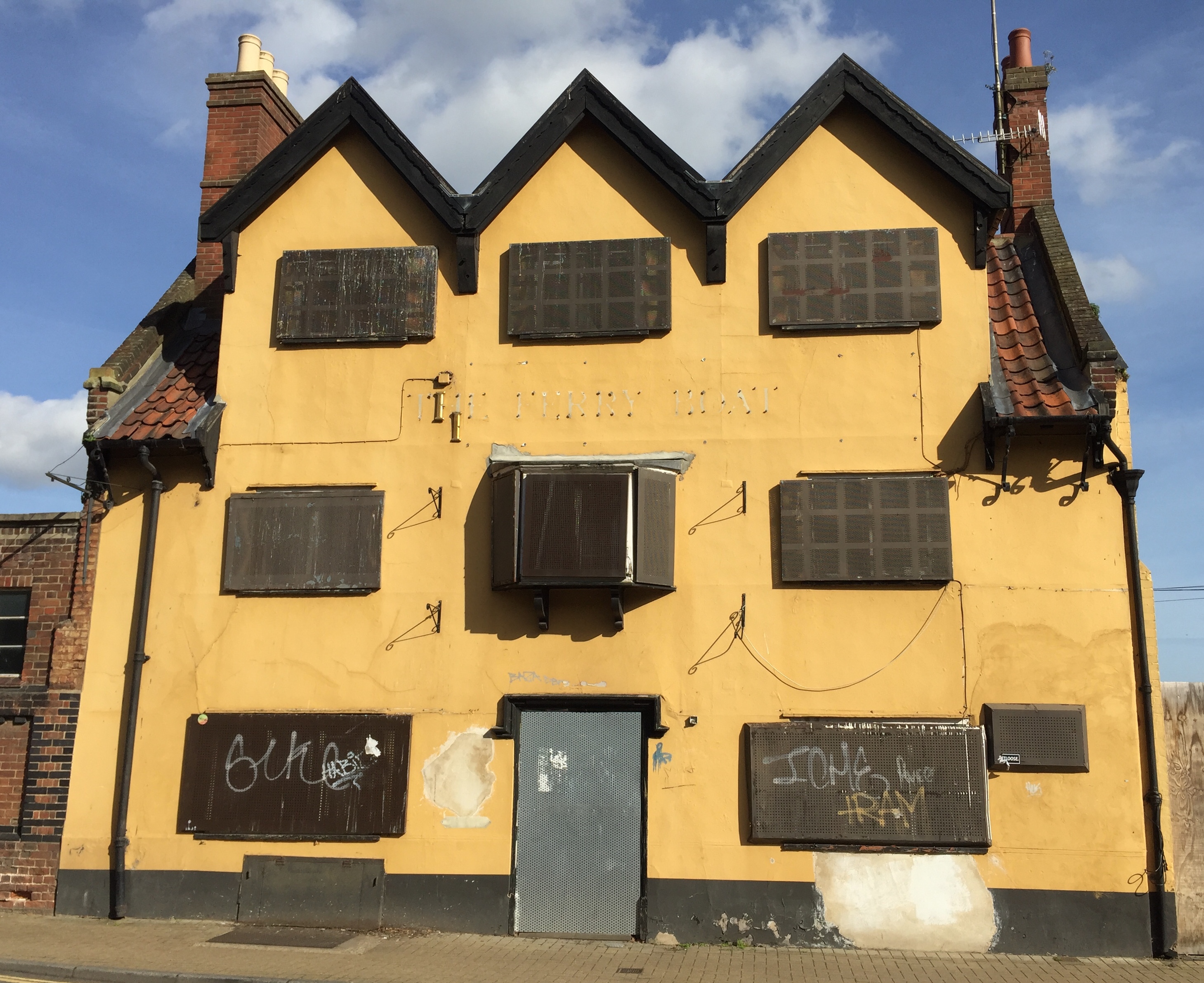
The Ferry Boat Inn

The Ferry Boat Inn was a public house and 150-capacity live music venue in Norwich, England, which closed in 2006. == History == The history of the Ferry...

Nearby Amenities

Located within 500m of 52.618593,1.3067212
Traffic Signals
Lat/Long: 52.621955/1.3073033
Crossing
Crossing: traffic_signals
Crossing Ref: pelican
Tactile Paving: yes
Traffic Signals Sound: no
Lat/Long: 52.6204184/1.3020825
Source: Landsat photo - shifted
Lat/Long: 52.622412/1.3047006
Source: Landsat photo - shifted
Lat/Long: 52.6217613/1.3054855
Source: Landsat photo - shifted
Lat/Long: 52.6208135/1.3075027
Source: Landsat photo - shifted
Lat/Long: 52.6205159/1.3084076
Source: Landsat photo - shifted
Lat/Long: 52.6203458/1.3092483
Source: Landsat photo - shifted
Lat/Long: 52.6201393/1.3102452
Source: Landsat photo - shifted
Lat/Long: 52.6200055/1.311154
Source: Landsat photo - shifted
Lat/Long: 52.6199239/1.3118475
Source: Landsat photo - shifted
Lat/Long: 52.6198603/1.3129975
Crossing
Button Operated: no
Crossing: traffic_signals
Crossing Island: yes
Tactile Paving: no
Traffic Signals Sound: no
Traffic Signals Vibration: no
Lat/Long: 52.6178237/1.3076532
Post Box
Collection Times: Mo-Fr 09:00, Sa 07:00
Operator: Royal Mail
Post Box Type: pillar
Ref: NR1 113D
Royal Cypher: VR
Royal Cypher Wikidata: Q33102356
Lat/Long: 52.6197768/1.307078
Post Box
Collection Times: Mo-Fr 09:00; Sa 07:00
Operator: Royal Mail
Post Box Type: pillar
Ref: NR1 112D
Royal Cypher: EIIR
Royal Cypher Wikidata: Q33102113
Lat/Long: 52.6189659/1.3042456
Post Box
Check Date Collection Times: 2022-03-27
Collection Times: Mo-Fr 09:00; Sa 07:00
Operator: Royal Mail
Post Box Type: lamp
Ref: NR1 121D
Royal Cypher: EIIR
Royal Cypher Wikidata: Q33102113
Lat/Long: 52.6175491/1.3011235
Crossing
Crossing: unmarked
Tactile Paving: no
Lat/Long: 52.6159256/1.3096878
Barrier: lift_gate
Lat/Long: 52.6159812/1.3084754
Crossing
Crossing: unmarked
Tactile Paving: no
Lat/Long: 52.6159847/1.3096571
Give Way
Lat/Long: 52.6161587/1.3078397
Give Way
Lat/Long: 52.6161206/1.3079991
Mini Roundabout
Direction: clockwise
Lat/Long: 52.6161246/1.3079154
Crossing
Lat/Long: 52.6161407/1.3058012
Barrier: lift_gate
Lat/Long: 52.615443/1.3085622
Barrier: kerb
Kerb: normal
Lat/Long: 52.6164309/1.3007855
Give Way
Lat/Long: 52.61768/1.2995789
Give Way
Lat/Long: 52.6173577/1.3024657
Crossing
Crossing: unmarked
Lat/Long: 52.6173556/1.3029353
Give Way
Lat/Long: 52.6174286/1.3024845
Give Way
Direction: forward
Lat/Long: 52.617612/1.3006537
Give Way
Lat/Long: 52.61752/1.30156
Crossing
Crossing: marked
Crossing Island: no
Crossing Ref: zebra
Tactile Paving: yes
Lat/Long: 52.6187969/1.2999236
Priority: equal
Lat/Long: 52.6174502/1.3054893
Crossing
Crossing Island: yes
Tactile Paving: yes
Lat/Long: 52.6192774/1.3036856
Crossing
Crossing: uncontrolled
Lat/Long: 52.6180113/1.3059438
Crossing
Crossing: unmarked
Lat/Long: 52.6186172/1.3044397
Turning Circle
Lat/Long: 52.616994/1.3006848
Lakenham
Place: suburb
Lat/Long: 52.6153383/1.3021692
Bench
Lat/Long: 52.6203919/1.3046774
Crossing
Crossing: unmarked
Crossing Island: yes
Tactile Paving: yes
Lat/Long: 52.6222741/1.3036725
Give Way
Direction: forward
Lat/Long: 52.6208121/1.3058185
Traffic Signals
Lat/Long: 52.6177047/1.3076066
Barrier: bollard
Lat/Long: 52.6214204/1.3065751
Crossing
Bicycle: yes
Crossing: uncontrolled
Crossing Island: no
Tactile Paving: no
Lat/Long: 52.6158705/1.3107675
Crossing
Bicycle: yes
Crossing: unmarked
Lat/Long: 52.6162354/1.3106133
Crossing
Bicycle: yes
Crossing: unmarked
Lat/Long: 52.6161829/1.3106839
Crossing
Bicycle: yes
Crossing: uncontrolled
Crossing Island: no
Tactile Paving: no
Lat/Long: 52.616001/1.3108476
Crossing
Crossing: unmarked
Tactile Paving: no
Lat/Long: 52.6163296/1.3100205
Crossing
Crossing: unmarked
Tactile Paving: no
Lat/Long: 52.616361/1.3101879
Crossing
Crossing: uncontrolled
Lat/Long: 52.6169203/1.310648
Crossing
Crossing: uncontrolled
Lat/Long: 52.6168666/1.3105917
Barrier: lift_gate
Bicycle: yes
Foot: yes
Lat/Long: 52.6164432/1.3111281
Barrier: lift_gate
Bicycle: yes
Foot: yes
Lat/Long: 52.6166072/1.3108877
Crossing
Crossing: uncontrolled
Lat/Long: 52.6165572/1.3115305
Crossing
Crossing: uncontrolled
Lat/Long: 52.6190129/1.3122386
Crossing
Crossing: uncontrolled
Lat/Long: 52.6168405/1.3134938
Crossing
Crossing: uncontrolled
Lat/Long: 52.6165995/1.3132069
Crossing
Crossing: uncontrolled
Lat/Long: 52.6195567/1.3098434
Crossing
Crossing: uncontrolled
Lat/Long: 52.6194786/1.3101974
Crossing
Crossing: uncontrolled
Lat/Long: 52.6192539/1.3115734
Crossing
Crossing: uncontrolled
Lat/Long: 52.6193809/1.3109297
Bus Stop
Corton Road, adj
Bus: yes
Naptan AtcoCode: 2900N12209
Naptan Bearing: NW
Naptan BusStopType: CUS
Naptan CommonName: Corton Road
Naptan Indicator: adj
Naptan Landmark: Corton Road
Naptan Locality: Norwich
Naptan NaptanCode: nfodjawd
Naptan PlusbusZoneRef: NRCH
Naptan Street: Bracondale
Naptan Verified: no
Public Transport: platform
Shelter: no
Source: naptan_import
Lat/Long: 52.6191911/1.3036249
Bus Stop
Bracondale / Corton Road
Bench: no
Bus: yes
Naptan AtcoCode: 2900N1227
Naptan Bearing: SE
Naptan BusStopType: CUS
Naptan CommonName: Corton Road
Naptan Indicator: opp
Naptan Landmark: Corton Road
Naptan Locality: Norwich
Naptan NaptanCode: nfodjgdp
Naptan PlusbusZoneRef: NRCH
Naptan Street: Bracondale
Public Transport: platform
Shelter: no
Source: naptan_import;survey
Lat/Long: 52.6197034/1.3032142
Bus Stop
Bus Shelter, Stand A
Local Ref: A
Naptan AtcoCode: 2900N1236
Naptan Bearing: SW
Naptan CommonName: Bus Shelter
Naptan Indicator: Stand A
Naptan Locality: County Hall
Naptan NaptanCode: nfodjpaw
Naptan PlusbusZoneRef: NRCH
Naptan Street: Lower Car Park
Shelter: yes
Source: naptan_import
Lat/Long: 52.6152545/1.3072751
Bus Stop
Bus Shelter, Stand B
Local Ref: B
Naptan AtcoCode: 2900N1237
Naptan Bearing: SW
Naptan CommonName: Bus Shelter
Naptan Indicator: Stand B
Naptan Locality: County Hall
Naptan NaptanCode: nfogmptw
Naptan PlusbusZoneRef: NRCH
Naptan Street: Lower Car Park
Shelter: yes
Source: naptan_import
Lat/Long: 52.6153536/1.3073845
Kensington Place, adj
Naptan AtcoCode: 2900N12446
Naptan Bearing: NE
Naptan BusStopType: CUS
Naptan CommonName: Kensington Place
Naptan Indicator: adj
Naptan Landmark: Kensington Place
Naptan Locality: Norwich
Naptan NaptanCode: nfodjtwm
Naptan PlusbusZoneRef: NRCH
Naptan Street: City Road
Naptan Verified: no
Source: naptan_import
Lat/Long: 52.6204858/1.3007373
Kensington Place, opp
Naptan AtcoCode: 2900N12447
Naptan Bearing: S
Naptan BusStopType: CUS
Naptan CommonName: Kensington Place
Naptan Indicator: opp
Naptan Landmark: Doman Road
Naptan Locality: Norwich
Naptan NaptanCode: nfodjtwp
Naptan PlusbusZoneRef: NRCH
Naptan Street: City Road
Naptan Verified: no
Source: naptan_import
Lat/Long: 52.6206131/1.3010129
Cricket Ground Road, adj
Naptan AtcoCode: 2900N12449
Naptan Bearing: S
Naptan BusStopType: CUS
Naptan CommonName: Cricket Ground Road
Naptan Indicator: adj
Naptan Landmark: Cricket Ground Road
Naptan Locality: Norwich
Naptan NaptanCode: nfodjwad
Naptan PlusbusZoneRef: NRCH
Naptan Street: City Road
Naptan Verified: no
Source: naptan_import
Lat/Long: 52.6174949/1.2996255
Bus Stop
Bracondale / Conisford Drive
Bus: yes
Naptan AtcoCode: 2900N12633
Naptan Bearing: NW
Naptan BusStopType: CUS
Naptan CommonName: King Street
Naptan Indicator: opp
Naptan Landmark: Conesford Drive
Naptan Locality: Norwich
Naptan NaptanCode: nfodmgwg
Naptan PlusbusZoneRef: NRCH
Naptan Street: Bracondale
Note: Sign spells Conesford Drive incorrectly
Public Transport: platform
Shelter: no
Source: naptan_import;survey
Lat/Long: 52.617968/1.306386
Bus Stop
Norwich / King Street
Bus: yes
Naptan AtcoCode: 2900N12634
Naptan Bearing: SE
Naptan BusStopType: CUS
Naptan CommonName: King Street
Naptan Indicator: adj
Naptan Landmark: King Street
Naptan Locality: Norwich
Naptan NaptanCode: nfodmgwj
Naptan PlusbusZoneRef: NRCH
Naptan Street: Bracondale
Public Transport: platform
Shelter: no
Source: naptan_import;survey
Lat/Long: 52.618003/1.306694
Bus Stop
Bracondale
Bench: no
Bin: no
Bus: yes
Lit: yes
Naptan AtcoCode: 2900N12635
Naptan Bearing: NW
Naptan BusStopType: CUS
Naptan CommonName: Bracondale
Naptan Indicator: NW-bound
Naptan Locality: Norwich
Naptan NaptanCode: nfodmgwm
Naptan PlusbusZoneRef: NRCH
Naptan Street: Bracondale
Naptan Verified: no
Public Transport: platform
Shelter: no
Source: naptan_import;survey
Tactile Paving: yes
Lat/Long: 52.6171695/1.3087036
Bus Stop
The Street, opp
Bench: no
Bin: no
Bus: yes
Lit: yes
Naptan AtcoCode: 2900N12636
Naptan Bearing: SE
Naptan CommonName: The Street
Naptan Indicator: opp
Naptan Landmark: Europa Way
Naptan Locality: Norwich
Naptan NaptanCode: nfodmgwp
Naptan PlusbusZoneRef: NRCH
Naptan ShortCommonName: The Street
Naptan Street: The Street
Naptan Verified: no
Public Transport: platform
Shelter: no
Source: naptan_import
Tactile Paving: yes
Lat/Long: 52.6156939/1.3112963
Bus Stop
Martineau Lane, opposite County Hall
Bench: yes
Bin: no
Bus: yes
Lit: yes
Naptan AtcoCode: 2900N12718
Naptan Bearing: S
Naptan CommonName: Martineau Lane
Naptan Indicator: opp
Naptan Landmark: County Hall
Naptan Locality: Norwich
Naptan NaptanCode: nfodmpta
Naptan PlusbusZoneRef: NRCH
Naptan ShortCommonName: Martineau Lane
Naptan Street: Martineau Lane
Naptan Verified: no
Public Transport: platform
Shelter: yes
Source: naptan_import
Tactile Paving: yes
Lat/Long: 52.6148601/1.3095932
Carrow Road CCTV Camera
Man Made: surveillance
Note: Permanent CCTV Camera.
Surveillance: public
Url: http://sites.google.com/site/norwichpolicecctv/
Lat/Long: 52.620918/1.305915
King Street CCTV Camera
Man Made: surveillance
Note: Permanent CCTV camera. Forward Vision MIC1-400 aluminium range.
Surveillance: public
Url: http://sites.google.com/site/norwichpolicecctv/
Lat/Long: 52.622429/1.303576
Wherry Road CCTV Camera
Man Made: surveillance
Note: Permanent CCTV Camera.
Surveillance: public
Url: http://sites.google.com/site/norwichpolicecctv/
Lat/Long: 52.622917/1.305465
Man Made: mast
Material: metal
Tower Construction: freestanding
Tower Type: lighting
Lat/Long: 52.6214845/1.3090289
Man Made: mast
Material: metal
Tower Construction: freestanding
Tower Type: lighting
Lat/Long: 52.6219409/1.3082084
Man Made: mast
Material: metal
Tower Construction: freestanding
Tower Type: lighting
Lat/Long: 52.6222899/1.3102044
Man Made: mast
Material: metal
Tower Construction: freestanding
Tower Type: lighting
Lat/Long: 52.6227347/1.309448
Waste Basket
Check Date: 2021-06-06
Colour: green
Material: plastic
Lat/Long: 52.6179659/1.3063868
Bench
Lat/Long: 52.617971/1.3063775
Bicycle Parking
Access: private
Capacity: 12
Covered: no
Lat/Long: 52.6227132/1.3071072
Bicycle Parking
Capacity: 30
Covered: no
Operator: Norwich City Council
Lat/Long: 52.6227039/1.3081271
Cafe
Costa
Addr City: Norwich
Addr Country: GB
Addr Housename: Unit 2c
Addr Housenumber: 2c
Addr Postcode: NR1 1WR
Addr Street: Albion Way
Brand: Costa
Brand Wikidata: Q608845
Brand Wikipedia: en:Costa Coffee
Check Date: 2023-09-03
Cuisine: coffee_shop
Fhrs Id: 22923
Phone: +44 1603 613441
Takeaway: yes
Lat/Long: 52.6226441/1.3072015
Entrance: yes
Lat/Long: 52.6149142/1.3071633
Crossing
Crossing: uncontrolled
Crossing Ref: zebra
Tactile Paving: no
Lat/Long: 52.6152074/1.3070421
Vending Machine
Vending: parking_tickets
Lat/Long: 52.6220435/1.3039451
Crossing
Crossing Island: yes
Tactile Paving: yes
Lat/Long: 52.622491/1.303076
Crossing
Crossing: unmarked
Tactile Paving: no
Lat/Long: 52.6156772/1.3099395
Bicycle Parking
Bicycle Parking: stands
Capacity: 30
Covered: no
Lat/Long: 52.6220457/1.3066197
Noexit: yes
Lat/Long: 52.6202052/1.3013808
Broadland Housing Association Head Office
Addr City: Norwich
Addr Country: GB
Addr Full: Broadland Housing Association, NCFC, Jarrold Stand, Carrow Road, Norwich, NR1 1HU
Addr Postcode: NR1 1HU
Addr Street: Carrow Road
Email: enq@broadlandgroup.org
Fax: +44 1603 750222
Fixme: Needs positioning
Office: housing_association
Opening Hours: Mo-Th 08:30-18:00; Fr 08:30-17:00
Phone: +44 3033 030003
Website: https://www.broadlandgroup.org
Lat/Long: 52.6216011/1.3100017
Access: customers
Barrier: lift_gate
Lat/Long: 52.6211992/1.3109527
Access: customers
Barrier: bollard
Lat/Long: 52.6213512/1.3101911
Traffic Calming: hump
Lat/Long: 52.6213897/1.3100239
Bicycle Parking
Bicycle Parking: stands
Capacity: 16
Covered: no
Lat/Long: 52.6214076/1.3111386
Barrier: bollard
Bicycle: yes
Bollard: fixed
Lat/Long: 52.6155663/1.3101346
Crossing
Crossing: unmarked
Tactile Paving: no
Lat/Long: 52.6156367/1.3100522
Crossing
Crossing: traffic_signals
Crossing Island: no
Crossing Ref: pelican
Kerb: flush
Tactile Paving: yes
Lat/Long: 52.6191926/1.3074569
Barrier: lift_gate
Bicycle: yes
Foot: yes
Lat/Long: 52.6165592/1.3110238
Barrier: lift_gate
Bicycle: yes
Foot: yes
Lat/Long: 52.6165988/1.3109756
Crossing
Crossing: unmarked
Crossing Island: yes
Tactile Paving: no
Lat/Long: 52.6177508/1.3074252
Barrier: bollard
Lat/Long: 52.6207374/1.3053767
Barrier: bollard
Lat/Long: 52.6210039/1.3050083
Passing Place
Lat/Long: 52.6150434/1.3028738
Crossing
Crossing: uncontrolled
Tactile Paving: no
Lat/Long: 52.6209777/1.301337
Crossing
Crossing: uncontrolled
Tactile Paving: no
Lat/Long: 52.6209867/1.3012121
Crossing
Crossing: unmarked
Lat/Long: 52.6181031/1.305606
Crossing
Crossing: unmarked
Lat/Long: 52.6190504/1.3037972
Bench
Backrest: yes
Colour: brown
Material: wood
Lat/Long: 52.6224537/1.3029833
Bench
Backrest: yes
Colour: brown
Material: wood
Lat/Long: 52.6224722/1.3029731
Post Box
Collection Times: Mo-Fr 17:45; Sa 13:15
Operator: Royal Mail
Post Box Mounting: brick_pillar
Post Box Type: wall
Ref: NR1 157
Royal Cypher: EIIR
Royal Cypher Wikidata: Q33102113
Lat/Long: 52.6151908/1.3072699
Letter Box
Colour: yellow
Description: Yellow box in a brick pillar for incoming mail to Norfolk County Council.
Letter Box Mounting: brick_pillar
Operator: Norfolk County Council
Lat/Long: 52.6152063/1.3072858
Elevator
Lat/Long: 52.6150899/1.3070793
Give Way
Lat/Long: 52.6209343/1.3013357
Entrance: main
Lat/Long: 52.6214982/1.3121992
Entrance: yes
Lat/Long: 52.6188334/1.2993712
Crossing
Crossing: uncontrolled
Kerb: raised
Lat/Long: 52.616596/1.3013957
Barrier: bollard
Bollard: fixed
Material: wood
Motor Vehicle: no
Lat/Long: 52.6164354/1.3009695
Noexit: yes
Lat/Long: 52.6157443/1.303164
Give Way
Lat/Long: 52.6174487/1.3015404
Bicycle Parking
Bicycle Parking: stands
Capacity: 10
Covered: no
Lat/Long: 52.620121/1.3081442
Bench
Lat/Long: 52.6204031/1.308348
Life Ring
Emergency: life_ring
Lat/Long: 52.6203933/1.3084573
Grit Bin
Lat/Long: 52.6208513/1.3069711
Life Ring
Emergency: life_ring
Lat/Long: 52.6208562/1.3069812
Grit Bin
Seasonal: no
Lat/Long: 52.6177671/1.3077888
Barrier: cycle_barrier
Lat/Long: 52.6205818/1.3058886
Bench
Backrest: yes
Material: wood
Lat/Long: 52.6211265/1.3013642
Barrier: kerb
Kerb: lowered
Tactile Paving: no
Lat/Long: 52.6209899/1.30117
Give Way
Lat/Long: 52.6208585/1.3010919
Bench
Backrest: yes
Lat/Long: 52.6157735/1.3106946
Grit Bin
Lat/Long: 52.6157424/1.3104461
Recycling
Check Date Recycling: 2020-11-20
Recycling Clothes: yes
Recycling Type: container
Lat/Long: 52.6153943/1.3117772
Restaurant
Delia's
Addr City: Norwich
Addr Housename: Norwich City Football Club
Addr Postcode: NR1 1JE
Addr Street: Geoffrey Watling Way
Check Date: 2023-09-03
Fhrs Id: 15206
Source Addr: FHRS Open Data
Lat/Long: 52.6217476/1.3082792
K&S Home Improvements
Craft: builder
Note: What type should this tag be? It's a builders yard rather than a shop. Modified to craft builder, remove this note is this is fine
Trade: building_supplies
Lat/Long: 52.6212937/1.3014939
Bicycle Parking
Bicycle Parking: stands
Covered: yes
Lat/Long: 52.6190566/1.3077324
Entrance: yes
Lat/Long: 52.615073/1.3109662
Door: sliding
Entrance: staircase
Lat/Long: 52.6149453/1.3064897
Crossing
Crossing: traffic_signals
Crossing Island: no
Crossing Ref: toucan
Tactile Paving: yes
Lat/Long: 52.6218312/1.3071486
Restaurant
The Kitchen County Hall
Access: private
Addr City: Norwich
Addr Housename: County Hall
Addr Postcode: NR1 2HU
Addr Street: Martineau Lane
Fhrs Id: 45197
Lat/Long: 52.6147259/1.3063375
Barrier: lift_gate
Lat/Long: 52.6153751/1.3086374
Defibrillator
Defibrillator Location: Inside County Hall, attached to a pillar by main reception desk on the ground floor.
Emergency: defibrillator
Indoor: yes
Lat/Long: 52.6148879/1.3072349
Simon O'Rourke
Artwork Type: statue
Material: wood
Tourism: artwork
Lat/Long: 52.6164408/1.3022463
Access: no
Barrier: bollard
Bicycle: yes
Bollard: fixed
Foot: yes
Motor Vehicle: no
Lat/Long: 52.6212332/1.3011631
Access: no
Barrier: bollard
Bicycle: yes
Bollard: fixed
Foot: yes
Motor Vehicle: no
Lat/Long: 52.6212755/1.3012333
Boom Towers
Fixme: Need complete text of this
Historic: memorial
Memorial: plaque
Lat/Long: 52.6208394/1.3069668
Restaurant
Yellows Bar and Grill
Addr City: Norwich
Addr Housename: Norwich City Football Club
Addr Postcode: NR1 1JE
Addr Street: Carrow Road
Fhrs Id: 15216
Source Addr: FHRS Open Data
Lat/Long: 52.621716/1.3079356
Addr Housename: Delias
Entrance: shop
Lat/Long: 52.621554/1.3081825
Match Day Betting
Shop: bookmaker
Lat/Long: 52.6213314/1.3086307
Power: transformer
Transformer: distribution
Lat/Long: 52.6204374/1.312236
Bicycle Rental
Norfolk County Council
Capacity: 10
Email: support@beryl.cc
Fee: yes
Name Signed: no
Network: Beryl - Norwich
Official Name: Norfolk County Council
Operator: Beryl
Operator Wikidata: Q106575369
Payment App: yes
Payment App Android: cc.beryl.basis
Payment App Ios: 1386768364
Payment Cash: no
Payment Credit Cards: no
Payment Cryptocurrencies: no
Payment Debit Cards: no
Payment Electronic Purses: no
Phone: +44 20 3003 5044
Ref Gbfs: beryl_norwich:1882
Rental: city_bike;ebike;escooter
Website: https://beryl.cc/scheme/norwich
Lat/Long: 52.6152115/1.3071899
Bicycle Rental
Riverside Leisure Centre
Capacity: 8
Email: support@beryl.cc
Fee: yes
Name Signed: no
Network: Beryl - Norwich
Official Name: Riverside Leisure Centre
Operator: Beryl
Operator Wikidata: Q106575369
Payment App: yes
Payment App Android: cc.beryl.basis
Payment App Ios: 1386768364
Payment Cash: no
Payment Credit Cards: no
Payment Cryptocurrencies: no
Payment Debit Cards: no
Payment Electronic Purses: no
Phone: +44 20 3003 5044
Ref Gbfs: beryl_norwich:1911
Rental: city_bike;ebike;escooter
Website: https://beryl.cc/scheme/norwich
Lat/Long: 52.6221542/1.306222
Door: hinged
Entrance: yes
Level: 0
Lat/Long: 52.620646/1.3122549
Door: hinged
Entrance: yes
Level: 0
Wheelchair: yes
Lat/Long: 52.6204037/1.3110802
Bicycle Parking
Lat/Long: 52.6206511/1.3122116
Bicycle Parking
Lat/Long: 52.6203866/1.3128751
Bicycle Parking
Lat/Long: 52.6205508/1.3133017
Waste Basket
Material: metal
Lat/Long: 52.6225468/1.3047405
Waste Basket
Colour: green
Material: plastic
Lat/Long: 52.6228257/1.3056376
Waste Basket
Lat/Long: 52.6212371/1.3068814
Waste Basket
Colour: green
Material: plastic
Lat/Long: 52.6218955/1.3114005
Waste Basket
Colour: green
Material: plastic
Lat/Long: 52.6220581/1.3069166
Waste Basket
Lat/Long: 52.6224158/1.303795
Waste Basket
Lat/Long: 52.6212719/1.3042285
Waste Basket
Colour: green
Material: plastic
Lat/Long: 52.6202684/1.3025397
Waste Basket
Colour: green
Material: plastic
Lat/Long: 52.6204415/1.3007432
Waste Basket
Colour: green
Material: plastic
Lat/Long: 52.6215893/1.3060068
Give Way
Lat/Long: 52.6204858/1.3008055
Entrance: main
Lat/Long: 52.6204956/1.3007026
Barrier: cycle_barrier
Bicycle: no
Lat/Long: 52.6202345/1.300511
Bicycle Parking
Lat/Long: 52.6215647/1.3077274
Bicycle Parking
Lat/Long: 52.6212649/1.3082037
Bicycle Parking
Lat/Long: 52.621401/1.3079854
Barrier: bollard
Bollard: fixed
Colour: dark_green
Material: metal
Lat/Long: 52.6173901/1.3020051
Give Way
Lat/Long: 52.6176717/1.2996877
Give Way
Lat/Long: 52.6155727/1.3111415
Crossing
Crossing: unmarked
Crossing Island: no
Tactile Paving: yes
Lat/Long: 52.6198904/1.3071988
Give Way
Lat/Long: 52.6198796/1.3071578
Crossing
Crossing: unmarked
Tactile Paving: yes
Lat/Long: 52.6209362/1.3056737
Give Way
Lat/Long: 52.6208448/1.3057034
Give Way
Lat/Long: 52.6208834/1.3058851
Entrance: yes
Lat/Long: 52.6205143/1.3119453
Entrance: main
Lat/Long: 52.620458/1.3113631
Bicycle Parking
Lat/Long: 52.6202162/1.3113546
Bench
Lat/Long: 52.6205247/1.3113458
Barrier: lift_gate
Lat/Long: 52.6160368/1.3086082
Barrier: lift_gate
Lat/Long: 52.6160165/1.3085425
Crossing
Crossing: uncontrolled
Crossing Ref: zebra
Lat/Long: 52.6159455/1.3077535
Give Way
Lat/Long: 52.6159932/1.3083183
Give Way
Lat/Long: 52.6162876/1.3074631
Give Way
Lat/Long: 52.6162477/1.3062304
Give Way
Lat/Long: 52.6161248/1.3062071
Give Way
Lat/Long: 52.6162484/1.3073363
Norwich Archive Centre Registration Office
Government: register_office
Office: government
Opening Hours: Mo-Fr 09:30-16:30; Sa-Su closed
Website: https://www.norfolk.gov.uk/births-ceremonies-and-deaths/registration-offices/norwich-registration-office
Wheelchair: yes
Lat/Long: 52.6148635/1.306504
Communication Mobile Phone: yes
Layer: 1
Man Made: mast
Material: metal
Operator: Three UK;EE
Tower Construction: guyed_tube
Tower Type: communication
Lat/Long: 52.6145703/1.3070606
Communication Mobile Phone: yes
Layer: 1
Man Made: mast
Material: metal
Operator: Three UK
Tower Construction: guyed_tube
Tower Type: communication
Lat/Long: 52.6227401/1.3094571
The data included in this document is from www.openstreetmap.org. The data is made available under ODbL.

Have you been to Bracondale Grove?

Leave your review of Bracondale Grove below (or comments, questions and feedback).