Long Wood
Wood, Forest in Suffolk Babergh
England
Long Wood

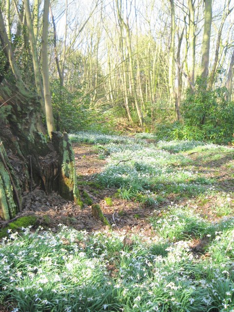
Long Wood is a picturesque forest located in the county of Suffolk, England. Situated near the village of Woodbridge, the woodland covers an expansive area of approximately 1,200 acres. It is renowned for its natural beauty and diverse ecosystem, attracting visitors from far and wide.
The forest is predominantly composed of deciduous trees, including oak, beech, and birch, which create a stunning display of colors during the autumn months. Long Wood is also home to a variety of wildlife, with deer, badgers, and a wide range of bird species being commonly spotted within its boundaries.
The wood is intersected by several footpaths and trails that allow visitors to explore its enchanting scenery. These paths lead to various points of interest, such as hidden ponds and meadows, providing opportunities for tranquil walks and wildlife observation.
Long Wood boasts a rich history, with evidence of human habitation dating back to the Neolithic period. It has been a source of timber for centuries, supplying materials for construction and fuel. Today, it serves as a valuable recreational space for locals and tourists alike, offering a peaceful retreat from the hustle and bustle of modern life.
The forest is managed by a local authority, which ensures the preservation and conservation of its natural habitats. Long Wood provides an important habitat for many rare and protected species, contributing to the overall biodiversity of the region.
In conclusion, Long Wood in Suffolk is a stunning forest that offers a tranquil escape for nature lovers. With its diverse range of flora and fauna, rich history, and well-maintained trails, it is a must-visit destination for anyone seeking to immerse themselves in the beauty of the English countryside.
If you have any feedback on the listing, please let us know in the comments section below.
Long Wood Images
Images are sourced within 2km of 51.99513/1.2032734 or Grid Reference TM2037. Thanks to Geograph Open Source API. All images are credited.


Long Wood is located at Grid Ref: TM2037 (Lat: 51.99513, Lng: 1.2032734)
Administrative County: Suffolk
District: Babergh
Police Authority: Suffolk
What 3 Words
///remove.driftwood.coached. Near Holbrook, Suffolk
Nearby Locations
Related Wikis

Pin Mill
Pin Mill is a hamlet on the south bank of the tidal River Orwell, on the outskirts of the village of Chelmondiston, on the Shotley peninsula in southern...

Chelmondiston
Chelmondiston is a small village and civil parish in Suffolk, England located on the Shotley Peninsula, five miles south-east of Ipswich. The hamlet of...
Woolverstone Hall School
In the early 1950s the London County Council obtained use of Woolverstone Hall near Ipswich, Suffolk, and some 50 acres (200,000 m2) of adjoining land...

Ipswich High School, Suffolk
Ipswich High School is a co-educational private school at Woolverstone Hall near Ipswich, England. Formerly an exclusive school for girls, it was converted...

Woolverstone
Woolverstone is a small village and civil parish in Suffolk, England located on the Shotley peninsula. It is situated about 6.4 km (4.0 mi) south of Ipswich...

Orwell Estuary
Orwell Estuary is a 1,335.7 hectare biological Site of Special Scientific Interest which stretches along the River Orwell and its banks between Felixstowe...

Orwell Park School
Orwell Park School is a day and boarding preparatory school for boys and girls in the village of Nacton on the edge of Ipswich in the English county of...

Broke Hall
Broke Hall is an English country house at Nacton, near Ipswich, Suffolk. It overlooks the River Orwell, opposite Pin Mill. The gardens were landscaped...
Nearby Amenities
Located within 500m of 51.99513,1.2032734Have you been to Long Wood?
Leave your review of Long Wood below (or comments, questions and feedback).