Catt's Shaw

Wood, Forest in Sussex Rother

England

Catt's Shaw

Path to Powdermill A public footpath runs along the outside of Rafters Wood towards Powdermill Bridge.  Walkers also have the choice of two flower-rich paths through the woods now owned by the Woodlands Trust.
Path to Powdermill Credit: David M Clark

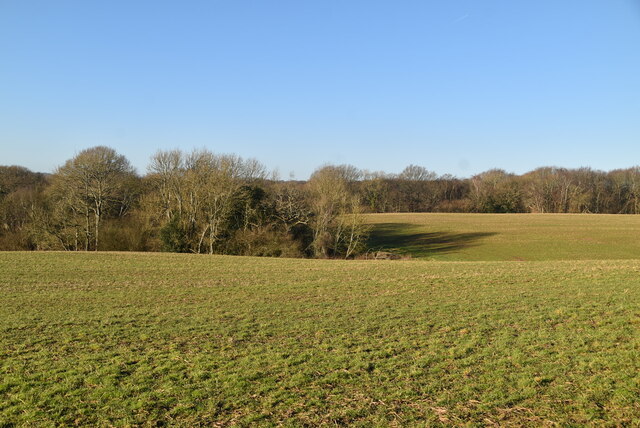
Catt's Shaw, located in Sussex, England, is a picturesque woodland area that encompasses a diverse range of flora and fauna. Spanning over a vast expanse, this forested region offers a tranquil and serene atmosphere, making it a popular destination for nature enthusiasts and hikers alike.

The woodlands of Catt's Shaw are home to a variety of tree species, including oak, beech, and ash. These towering trees create a dense canopy, which provides shelter and habitat for numerous animal species. Visitors may spot woodland creatures such as deer, foxes, badgers, and a wide array of bird species.

The forest floor is adorned with a rich diversity of plants and wildflowers, adding vibrant bursts of color to the landscape. Bluebells, primroses, and wild garlic are just a few examples of the flora that thrive in this enchanting woodland.

Tranquil streams meander through Catt's Shaw, adding to the overall charm and beauty of the area. These waterways provide a habitat for aquatic life, including frogs, newts, and various insect species.

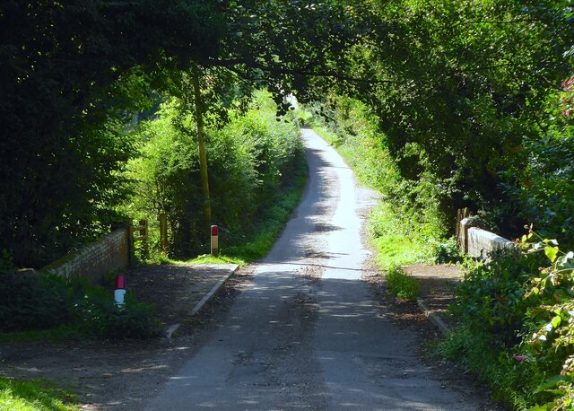
For those seeking outdoor activities, Catt's Shaw offers a network of footpaths and trails, allowing visitors to explore the forest and discover its hidden treasures. Whether it's a leisurely stroll or a more challenging hike, the woodland's well-maintained paths cater to all levels of fitness and interest.

Catt's Shaw, Sussex is a true haven for nature lovers, offering a captivating blend of natural beauty, diverse wildlife, and recreational opportunities. Whether one seeks solace in its peaceful surroundings or an adventure through its winding paths, this woodland area never fails to leave a lasting impression.

If you have any feedback on the listing, please let us know in the comments section below.

Catt's Shaw Images

Images are sourced within 2km of 50.933042/0.53978876 or Grid Reference TQ7817. Thanks to Geograph Open Source API. All images are credited.

Path to Powdermill A public footpath runs along the outside of Rafters Wood towards Powdermill Bridge.  Walkers also have the choice of two flower-rich paths through the woods now owned by the Woodlands Trust.
Path to Powdermill
A public footpath runs along the outside of Rafters Wood towards Powdermill Bridge. Walkers also have the choice of two flower-rich paths through the woods now owned by the Woodlands Trust.
High Weald pasture
High Weald pasture
Rafters Wood
Rafters Wood
Rafters Wood
Rafters Wood
Rafters Wood
Rafters Wood
Rafters Wood
Rafters Wood
Powdermill Reservoir outflow
Powdermill Bridge
Powdermill Bridge
Gauging station
Gauging station
Field by Rafters Wood
Mill Plat (1) The name of the field according to Brede's 1840 tithe map. Prior to the construction of Powdermill Reservoir in the 1930s a pond bay ran from Powdermill Bridge to the former Powdermill Farm. This served the former Brede Forge and Furnace that operated from 1577 to 1766. The site later became a powdermill that may have operated until the 1820s when the former hammer pond was drained. Part of that pond is now the reservoir with its existence still noted in Pond Wood to the immediate east. See also <a href="https://www.geograph.org.uk/photo/7569619">TQ8019 : Mill Plat (2)</a>.
Mill Plat (1)
The name of the field according to Brede's 1840 tithe map. Prior to the construction of Powdermill Reservoir in the 1930s a pond bay ran from Powdermill Bridge to the former Powdermill Farm. This served the former Brede Forge and Furnace that operated from 1577 to 1766. The site later became a powdermill that may have operated until the 1820s when the former hammer pond was drained. Part of that pond is now the reservoir with its existence still noted in Pond Wood to the immediate east. See also TQ8019 : Mill Plat (2).
Mill Plat (2) The name of the field according to Brede's 1840 tithe map and once the site of Brede Forge and Furnace that operated here from 1577 to 1766. The site was later used as a powdermill until around the 1820s when the former hammer pond was drained. The pond bay, see <a href="https://www.geograph.org.uk/photo/7569617">TQ8019 : Mill Plat (1)</a>,  survived until the 1930s when it was removed for the construction of Powdermill Reservoir, whose dam can be clearly seen. The reservoir also contains most of the site of the former pond.
Mill Plat (2)
The name of the field according to Brede's 1840 tithe map and once the site of Brede Forge and Furnace that operated here from 1577 to 1766. The site was later used as a powdermill until around the 1820s when the former hammer pond was drained. The pond bay, see TQ8019 : Mill Plat (1), survived until the 1930s when it was removed for the construction of Powdermill Reservoir, whose dam can be clearly seen. The reservoir also contains most of the site of the former pond.
Powdermill Bridge Carrying Reservoir Lane over a tributary of the River Brede. The OS maps still mark the highway as Powdermill Lane though West Sussex Council have now officially designated it as Reservoir Lane.
Powdermill Bridge
Carrying Reservoir Lane over a tributary of the River Brede. The OS maps still mark the highway as Powdermill Lane though West Sussex Council have now officially designated it as Reservoir Lane.
Unnamed Tributary, River Brede The straight nature of the stream precedes the construction of Powdermill Reservoir in the 1930s way back to when the adjacent field, see <a href="https://www.geograph.org.uk/photo/7569619">TQ8019 : Mill Plat (2)</a>, was the site of Brede Forge and Furnace.
Unnamed Tributary, River Brede
The straight nature of the stream precedes the construction of Powdermill Reservoir in the 1930s way back to when the adjacent field, see TQ8019 : Mill Plat (2), was the site of Brede Forge and Furnace.
Cinder Plat The name of the field according to Brede's 1840 tithe map located to the south of Reservoir Lane and the site of Brede Forge and Furnace, see <a href="https://www.geograph.org.uk/photo/7569619">TQ8019 : Mill Plat (2)</a>.
Cinder Plat
The name of the field according to Brede's 1840 tithe map located to the south of Reservoir Lane and the site of Brede Forge and Furnace, see TQ8019 : Mill Plat (2).
Upper Brook The name of the field according to Brede's 1840 tithe map located to the west of Rafters Wood.
Upper Brook
The name of the field according to Brede's 1840 tithe map located to the west of Rafters Wood.
Lower Brook The name of the field according to Brede's 1840 tithe map bounded by Horn's Wood to the east and Brede Lane to the south.
Lower Brook
The name of the field according to Brede's 1840 tithe map bounded by Horn's Wood to the east and Brede Lane to the south.
Brede Lane A country lane that links Sedlescombe to Brede. Here it skirts the southern side of Horn's Wood.
Brede Lane
A country lane that links Sedlescombe to Brede. Here it skirts the southern side of Horn's Wood.
Show me another place!

Catt's Shaw is located at Grid Ref: TQ7817 (Lat: 50.933042, Lng: 0.53978876)

Administrative County: East Sussex

District: Rother

Police Authority: Sussex

What 3 Words

///moth.rudder.ordeals. Near Battle, East Sussex

Related Wikis

Sedlescombe

Sedlescombe is a village and civil parish in the Rother district of East Sussex, England. The village is on the B2244 road, about 6 miles (10 km) north...

Durhamford Manor

Durhamford Manor is a Grade II* listed country house in the parish of Sedlescombe, East Sussex, England. The timber-framed, close-studded house dates to...

Whatlington

Whatlington is a village and civil parish in the Rother district of East Sussex, England. The village is seven miles (11 km) north of Hastings, just off...

Powdermill Reservoir

Powdermill Reservoir lies to the east of Sedlescombe, East Sussex, England. The reservoir provides water for Southern Water customers. == History == Originally...

Brede Waterworks

Brede Waterworks (grid reference TQ 813 178) is a waterworks at Brede, East Sussex, England. It was built to supply Hastings with drinking water. The waterworks...

Sedlescombe vineyard

Sedlescombe organic vineyard is an English vineyard located in Robertsbridge, just outside Sedlescombe in East Sussex.It is one of the few British vineyards...

Hemingfold Meadow

Hemingfold Meadow is a 4.9-hectare (12-acre) biological Site of Special Scientific Interest west of Battle in East Sussex.This site consists of two adjacent...

Cripps Corner

Cripps Corner is a village in the civil parish of Ewhurst and the Rother district of East Sussex, England. It is in the High Weald Area of Outstanding...

Nearby Amenities

Located within 500m of 50.933042,0.53978876
Sedlescombe
Is In: East Sussex, England, UK
Place: village
Wikidata: Q2295637
Wikipedia: en:Sedlescombe
Lat/Long: 50.9331879/0.5344641
Post Box
Collection Times: Mo-Fr 17:00; Sa 11:15
Operator: Royal Mail
Operator Wikidata: Q638098
Post Box Type: pillar
Postal Code: TN33
Ref: TN33 148
Lat/Long: 50.9334733/0.5343565
The Brickwall Hotel
Addr Postcode: TN33 0QA
Addr Street: The Green
Addr Village: Sedlescombe
Fhrs Id: 782603
Source Addr: FHRS Open Data
Tourism: hotel
Wikidata: Q26516424
Lat/Long: 50.9342655/0.5338142
Turning Circle
Lat/Long: 50.9359293/0.5365662
Barrier: stile
Lat/Long: 50.9348749/0.5415031
Barrier: stile
Lat/Long: 50.9352363/0.5436295
Fountain
Lat/Long: 50.9330049/0.5332968
Removed Amenity: telephone
Lat/Long: 50.9346127/0.5331386
Bus Stop
Bus: yes
Naptan AtcoCode: 1400RR0363
Naptan NaptanCode: esuatgjt
Public Transport: platform
Lat/Long: 50.9319527/0.5351161
Bus Stop
Bus: yes
Naptan AtcoCode: 1400RR0362
Naptan NaptanCode: esuatgjp
Public Transport: platform
Shelter: yes
Lat/Long: 50.9320477/0.5351872
Waste Basket
Lat/Long: 50.933309/0.5344326
Waste Basket
Lat/Long: 50.93338/0.5343852
Man Made: utility_pole
Lat/Long: 50.9315125/0.5351231
Man Made: utility_pole
Lat/Long: 50.9310713/0.5343328
Bench
Lat/Long: 50.9333606/0.5343566
Bench
Lat/Long: 50.9333137/0.5343856
Post Box
Collection Times: Mo-Fr 09:00; Sa 07:00
Operator: Royal Mail
Operator Wikidata: Q638098
Post Box Type: lamp
Ref: TN33 221D
Royal Cypher: EIIR
Royal Cypher Wikidata: Q33102113
Lat/Long: 50.9364102/0.5412881
Phone: +441424871424
Shop: antiques
Lat/Long: 50.931623/0.5350618
Bridge Garage
Shop: car_repair
Lat/Long: 50.9317326/0.5349882
Direction: 160
Information: board
Tourism: information
Lat/Long: 50.9334679/0.5345299
Generator Method: photovoltaic
Generator Source: solar
Generator Type: solar_photovoltaic_panel
Location: roof
Power: generator
Lat/Long: 50.9344662/0.5354762
The data included in this document is from www.openstreetmap.org. The data is made available under ODbL.

Have you been to Catt's Shaw?

Leave your review of Catt's Shaw below (or comments, questions and feedback).