Larch Belt
Wood, Forest in Lincolnshire East Lindsey
England
Larch Belt

Larch Belt, located in the county of Lincolnshire, is a picturesque wood known for its dense and vibrant forest. Covering an area of approximately 50 square miles, this natural gem is a haven for nature enthusiasts and outdoor adventurers alike. The forest is primarily composed of larch trees, which lend their name to the area.
The landscape of Larch Belt is characterized by rolling hills, deep valleys, and meandering streams that cut through the wooded expanse. The forest floor is blanketed with a diverse array of flora, including ferns, wildflowers, and mosses, creating a rich tapestry of colors and textures. This vibrant ecosystem supports a wide range of wildlife, including deer, foxes, rabbits, and a variety of bird species.
Visitors to Larch Belt can explore numerous walking trails and hiking paths that wind their way through the forest, offering breathtaking views and opportunities for spotting wildlife. Nature enthusiasts can also partake in birdwatching, as the area is home to several rare bird species.
The wood is managed by a dedicated team of forestry experts who ensure the conservation and preservation of the area. They actively promote sustainable practices and work towards maintaining the delicate balance of the ecosystem.
Larch Belt is not only a natural treasure but also a place of tranquility and serenity, offering visitors a chance to escape the hustle and bustle of everyday life. Whether it's a leisurely stroll through the forest or an immersive exploration of its hidden corners, Larch Belt promises an unforgettable experience for all who venture into its enchanting embrace.
If you have any feedback on the listing, please let us know in the comments section below.
Larch Belt Images
Images are sourced within 2km of 53.210222/0.062561225 or Grid Reference TF3770. Thanks to Geograph Open Source API. All images are credited.


Larch Belt is located at Grid Ref: TF3770 (Lat: 53.210222, Lng: 0.062561225)
Administrative County: Lincolnshire
District: East Lindsey
Police Authority: Lincolnshire
What 3 Words
///coconuts.tape.hounded. Near Spilsby, Lincolnshire
Nearby Locations
Related Wikis

Aswardby
Aswardby (pronounced "as-ard-bee") is a village situated 4 miles (6 km) north-west from Spilsby, in the East Lindsey district of Lincolnshire, England...

Sausthorpe
Sausthorpe is a small village and civil parish in the East Lindsey district of Lincolnshire, England, 8 miles (13 km) east of Horncastle and 3 miles (4...

Langton by Spilsby
Langton by Spilsby, sometimes called Langton by Partney, is a village and civil parish in the East Lindsey district of Lincolnshire, England. It is situated...

Harrington, Lincolnshire
Harrington is a hamlet and civil parish in the East Lindsey district of Lincolnshire, England. It is situated 6 miles (10 km) south-west from Alford, and...
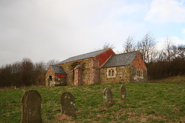
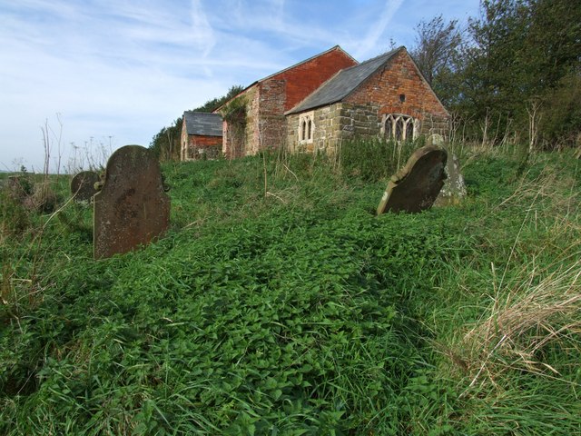
St John the Baptist's Church, Sutterby
St John the Baptist's Church is a redundant Anglican church in the village of Sutterby, Lincolnshire, England. It is recorded in the National Heritage...
Sutterby
Sutterby is a hamlet in the civil parish of Langton by Spilsby, in the East Lindsey district of Lincolnshire, England. It is situated 9 miles (14 km) south...

Thornbury Hill
Thornbury Hill is a hill in Hagworthingham, Lincolnshire, England.

Dalby, Lincolnshire
Dalby is a village and civil parish in the East Lindsey district of Lincolnshire, England. It is situated approximately 3 miles (5 km) north from the town...
Nearby Amenities
Located within 500m of 53.210222,0.062561225Have you been to Larch Belt?
Leave your review of Larch Belt below (or comments, questions and feedback).