Coalpit Wood

Wood, Forest in Sussex Mid Sussex

England

Coalpit Wood

Path in Big Wood, Bedelands Farm A local nature reserve.
Path in Big Wood, Bedelands Farm Credit: Robin Webster

Coalpit Wood is a picturesque woodland located in the county of Sussex, England. Covering an area of approximately 50 acres, it is situated near the village of Coalpit Heath, which is known for its rich history in coal mining. The wood is part of the wider Forest of Dean, an ancient woodland that has been protected for centuries.

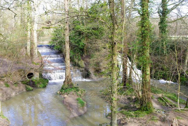
Coalpit Wood is characterized by its diverse range of tree species, including oak, beech, ash, and hazel. These trees create a dense canopy that provides shade and shelter for a variety of wildlife. The woodland floor is adorned with a carpet of bluebells during the spring, creating a stunning display of color.

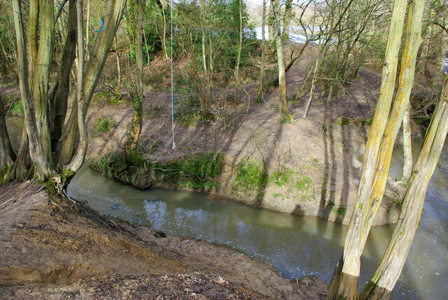
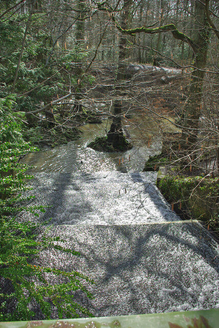
The woodland is crisscrossed with well-maintained footpaths, allowing visitors to explore its natural beauty. These paths lead to several points of interest, such as a tranquil pond and a clearing where visitors can enjoy a picnic surrounded by nature. There are also designated areas for birdwatching, as the wood is home to a range of bird species, including woodpeckers, tawny owls, and great tits.

Coalpit Wood is a popular destination for nature lovers, hikers, and families looking to escape the hustle and bustle of daily life. It offers a peaceful and serene environment, ideal for those seeking solitude or wanting to reconnect with nature. With its stunning scenery and abundant wildlife, Coalpit Wood truly showcases the natural beauty of Sussex.

If you have any feedback on the listing, please let us know in the comments section below.

Coalpit Wood Images

Images are sourced within 2km of 50.983473/-0.10383077 or Grid Reference TQ3322. Thanks to Geograph Open Source API. All images are credited.

Path in Big Wood, Bedelands Farm A local nature reserve.
Path in Big Wood, Bedelands Farm
A local nature reserve.
Spillways, Valebridge Pond On the eastern branch of the River Adur.
Spillways, Valebridge Pond
On the eastern branch of the River Adur.
Blue rope hanging over River Adur Standard equipment for such places.
Blue rope hanging over River Adur
Standard equipment for such places.
Spillway, Valebridge Pond On the eastern branch of the River Adur.
Spillway, Valebridge Pond
On the eastern branch of the River Adur.
Woodland east of Freek's Lane
Woodland drainage running down to River Adur To the east of Freek's Lane.
Woodland drainage running down to River Adur
To the east of Freek's Lane.
Footpath junction near River Adur Freek's Lane, if it is still called that, continues straight on, changing footpath number from 96CR to 94CR. Right is 95CR, following the Adur valley up to the Valebridge pond bay.
Footpath junction near River Adur
Freek's Lane, if it is still called that, continues straight on, changing footpath number from 96CR to 94CR. Right is 95CR, following the Adur valley up to the Valebridge pond bay.
Footpath 94CR heading north This might still be called Freek's Lane, the route certainly is behind the camera, that part has reference 96CR. Right is 95CR, following the Adur valley up to the Valebridge pond bay.
Footpath 94CR heading north
This might still be called Freek's Lane, the route certainly is behind the camera, that part has reference 96CR. Right is 95CR, following the Adur valley up to the Valebridge pond bay.
By the River Adur The river, not very big, is over by the central tree.
By the River Adur
The river, not very big, is over by the central tree.
Footpath 95CR towards Valebridge Pond Or an approximation to it, both my GPS devices showed something somewhat north of the mapped route.
Footpath 95CR towards Valebridge Pond
Or an approximation to it, both my GPS devices showed something somewhat north of the mapped route.
River Adur, eastern branch Looking upstream towards Valebridge Pond.
River Adur, eastern branch
Looking upstream towards Valebridge Pond.
River Adur, eastern branch Looking upstream towards Valebridge Pond.
River Adur, eastern branch
Looking upstream towards Valebridge Pond.
River Adur, eastern branch Looking downstream.
River Adur, eastern branch
Looking downstream.
River Adur, eastern branch Looking upstream towards Valebridge Pond.
River Adur, eastern branch
Looking upstream towards Valebridge Pond.
River Adur, eastern branch The flow is from the right.
River Adur, eastern branch
The flow is from the right.
Footbridge over River Adur, eastern branch Footpath 95CR crosses.
Footbridge over River Adur, eastern branch
Footpath 95CR crosses.
Change of direction for footpath 95CR Having come along a field from the right on the north side of the Adur, the sign directs to a footbridge to continue on the south side. There appears to be a path on the north side continuing to the left, but it is not public. This latter path passes through the hedge gap, and so over the course of the tail race for the former Valebridge Mill. The race appears to no longer take flow from the mill pond.
Change of direction for footpath 95CR
Having come along a field from the right on the north side of the Adur, the sign directs to a footbridge to continue on the south side. There appears to be a path on the north side continuing to the left, but it is not public. This latter path passes through the hedge gap, and so over the course of the tail race for the former Valebridge Mill. The race appears to no longer take flow from the mill pond.
Show me another place!

Coalpit Wood is located at Grid Ref: TQ3322 (Lat: 50.983473, Lng: -0.10383077)

Administrative County: West Sussex

District: Mid Sussex

Police Authority: Sussex

What 3 Words

///report.rotate.dime. Near Haywards Heath, West Sussex

Related Wikis

St Francis Rangers F.C.

St Francis Rangers F.C. is a football club based in Haywards Heath, England. They are currently members of the Southern Combination Division Two and play...

St Francis Hospital, Haywards Heath

St Francis Hospital was a mental health facility in Haywards Heath, West Sussex, England. The main building survives and is a Grade II listed building...

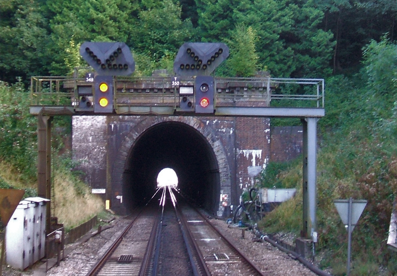
Haywards Heath Tunnel

Haywards Heath tunnel, also known as Folly Hill tunnel, is a railway tunnel on the Brighton Main Line between Haywards Heath and Wivelsfield. It is 249...

Ashenground and Bolnore Woods

Ashenground and Bolnore Woods is a 14.4-hectare (36-acre) Local Nature Reserve in Haywards Heath in West Sussex. It is owned and managed by Mid Sussex...

Jireh Chapel, Haywards Heath

The Jireh Chapel is a Strict Baptist place of worship in the town of Haywards Heath in the English county of West Sussex. The chapel was built in 1879...

Princess Royal Hospital, Haywards Heath

The Princess Royal Hospital, also known as PRH, is an acute, teaching, general hospital located in Haywards Heath, West Sussex, England. It is the main...

Haywards Heath East (electoral division)

Haywards Heath East is an electoral division of West Sussex in the United Kingdom, and returns one member to sit on West Sussex County Council. == Extent... ==

St Wilfrid's Church, Haywards Heath

St Wilfrid's Church is an Anglican church in the town of Haywards Heath in the district of Mid Sussex, one of seven local government districts in the English...

Nearby Amenities

Located within 500m of 50.983473,-0.10383077
Traffic Calming: island
Lat/Long: 50.986875/-0.1051714
Crossing
Bicycle: yes
Button Operated: yes
Crossing: traffic_signals
Crossing Island: no
Crossing Ref: toucan
Kerb: lowered
Tactile Paving: yes
Traffic Signals Sound: yes
Lat/Long: 50.9868581/-0.1064374
Turning Circle
Lat/Long: 50.9857985/-0.103596
Turning Loop
Lat/Long: 50.9831339/-0.0996035
Bus Stop
Weald Rise
Bus: yes
Naptan AtcoCode: 4400EG0016
Naptan Bearing: N
Naptan CommonName: Weald Rise
Naptan Indicator: adj Weald Rise
Naptan Landmark: Weald Rise
Naptan NaptanCode: wsxampdt
Naptan Street: Fox Hill
Naptan Verified: no
Public Transport: platform
Source: naptan_import
Lat/Long: 50.9840886/-0.0990675
Bus Stop
Burchetts Close
Bus: yes
Naptan AtcoCode: 4400EG0029
Naptan Bearing: W
Naptan CommonName: Burchetts Close
Naptan Indicator: opp flats
Naptan Landmark: Burchetts Close
Naptan NaptanCode: wsxampjp
Naptan PlusbusZoneRef: HYWRDSH
Naptan Street: Bolding Way
Naptan Verified: no
Public Transport: platform
Source: naptan_import
Lat/Long: 50.9875793/-0.1035615
Bus Stop
Burchetts Close
Bus: yes
Naptan AtcoCode: 4400EG0030
Naptan Bearing: E
Naptan CommonName: Burchetts Close
Naptan Indicator: opp 16
Naptan Landmark: Burchetts Close
Naptan NaptanCode: wsxampjt
Naptan PlusbusZoneRef: HYWRDSH
Naptan Street: Bolding Way
Naptan Verified: no
Public Transport: platform
Source: naptan_import
Lat/Long: 50.9875803/-0.1041742
Fox Hill
Is In: Haywards Heath;West Sussex;England;United Kingdom
Place: neighbourhood
Lat/Long: 50.9835495/-0.0998006
Post Box
Brand: Royal Mail
Brand Wikidata: Q638098
Brand Wikipedia: en:Royal Mail
Operator: Royal Mail
Operator Wikidata: Q638098
Post Box Type: lamp
Ref: RH16 182D
Royal Cypher: EIIR
Royal Cypher Wikidata: Q33102113
Lat/Long: 50.9876983/-0.1035461
Crossing
Lat/Long: 50.9874682/-0.1005721
Crossing
Lat/Long: 50.9873791/-0.1009084
Crossing
Lat/Long: 50.9873972/-0.1010316
Crossing
Lat/Long: 50.9875353/-0.1012802
Crossing
Lat/Long: 50.9876057/-0.1013107
Bus Stop
Old House Farm
Bus: yes
Public Transport: platform
Lat/Long: 50.986517/-0.1089046
Addr City: Haywards Heath
Addr Housename: Sandrocks Lodge
Addr Postcode: RH16 4RN
Addr Street: Rocky Lane
Lat/Long: 50.9868546/-0.1073733
The data included in this document is from www.openstreetmap.org. The data is made available under ODbL.

Have you been to Coalpit Wood?

Leave your review of Coalpit Wood below (or comments, questions and feedback).