Scotland Plantation

Wood, Forest in Lincolnshire East Lindsey

England

Scotland Plantation

Direction Sign – Signpost on Rowgate Road, Scamblesby parish Located on the northwest side of the crossroads of Rowgate Road and Oslear's Lane, east of the village, Scamblesby parish. 4 arms and no finial. See also <a title="https://www.geograph.org.uk/photo/466098" href="https://www.geograph.org.uk/photo/466098">Link</a>.

Milestone Society National ID: LI_TF2978
Direction Sign – Signpost on Rowgate Road, Scamblesby parish Credit: A Riley

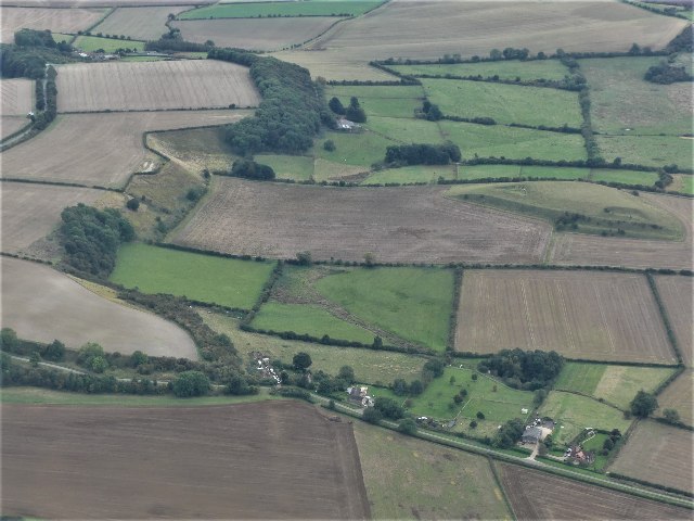
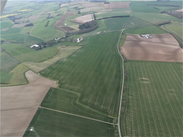
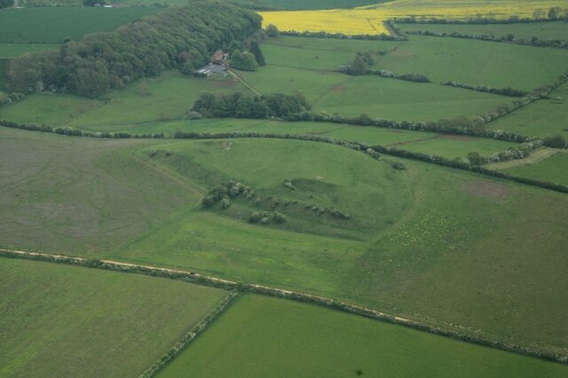
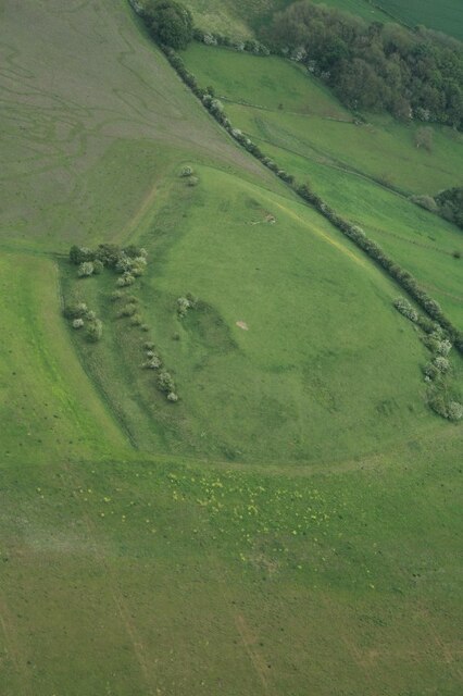
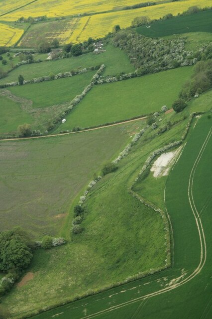
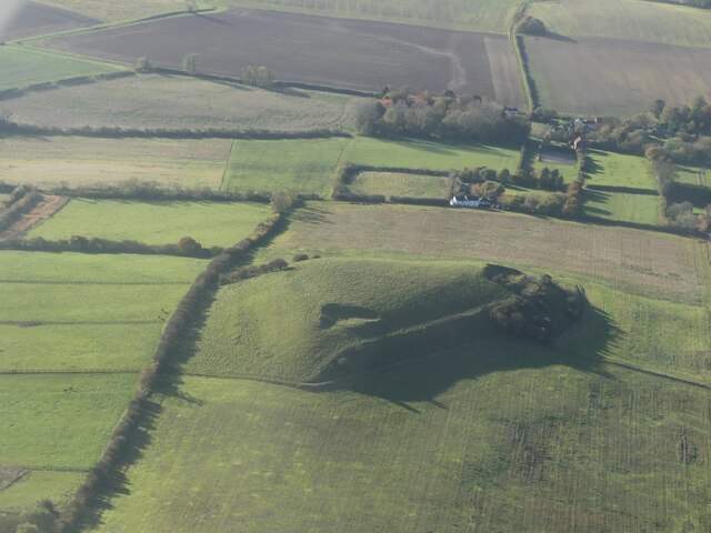
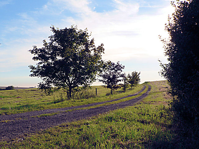
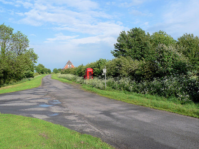
Scotland Plantation is a sprawling woodland located in the county of Lincolnshire, England. Situated near the village of Wood, this picturesque forest covers an extensive area of approximately 500 acres. The plantation is renowned for its rich biodiversity and stunning natural beauty.

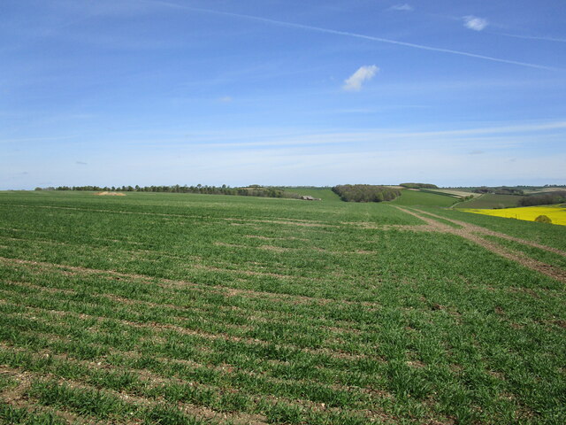
The woodland consists primarily of native trees such as oak, ash, and beech, which create a dense canopy overhead, providing a habitat for a wide range of flora and fauna. The forest floor is carpeted with a diverse array of wildflowers, creating a colorful and vibrant landscape throughout the year.

Scotland Plantation is a popular destination for nature enthusiasts, hikers, and photographers. The forest offers a multitude of walking trails, allowing visitors to explore its hidden corners and discover its many treasures. Along these paths, one can encounter various wildlife species, including deer, squirrels, and a variety of bird species, making it an ideal spot for birdwatching.

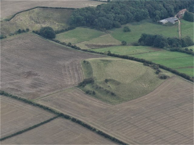
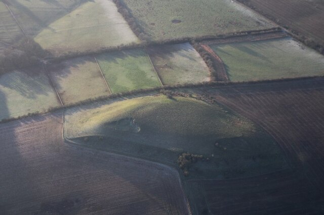
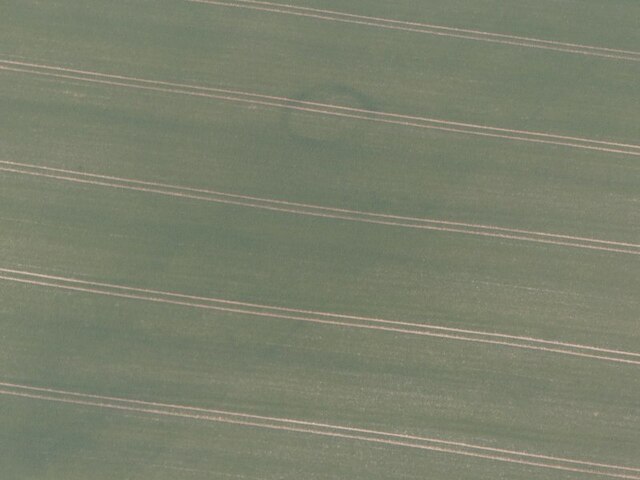
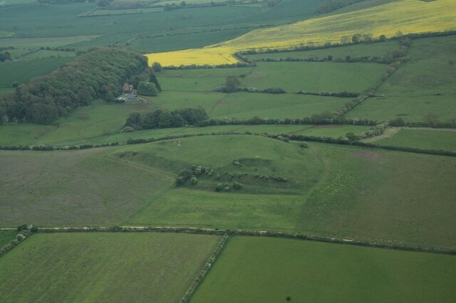
The plantation is also of historical significance, with evidence of human activity dating back centuries. Remnants of ancient settlements, including burial mounds and earthworks, can be found within the forest, providing a glimpse into the area's past.

Overall, Scotland Plantation in Lincolnshire is a captivating woodland destination that offers a serene and immersive experience in nature. Its combination of stunning landscapes, abundant wildlife, and historical significance make it a must-visit location for anyone seeking a peaceful retreat or a deeper connection with the natural world.

If you have any feedback on the listing, please let us know in the comments section below.

Scotland Plantation Images

Images are sourced within 2km of 53.285891/-0.051083436 or Grid Reference TF3078. Thanks to Geograph Open Source API. All images are credited.

Direction Sign – Signpost on Rowgate Road, Scamblesby parish Located on the northwest side of the crossroads of Rowgate Road and Oslear's Lane, east of the village, Scamblesby parish. 4 arms and no finial. See also <a title="https://www.geograph.org.uk/photo/466098" href="https://www.geograph.org.uk/photo/466098">Link</a>.

Milestone Society National ID: LI_TF2978
Direction Sign – Signpost on Rowgate Road, Scamblesby parish
Located on the northwest side of the crossroads of Rowgate Road and Oslear's Lane, east of the village, Scamblesby parish. 4 arms and no finial. See also Link. Milestone Society National ID: LI_TF2978
Gaumer Hill, Scamblesby: aerial 2021 (1) See <span class="nowrap"><a title="https://www.heritagegateway.org.uk/Gateway/Results_Single.aspx?uid=MLI42287&resourceID=1006" rel="nofollow ugc noopener" href="https://www.heritagegateway.org.uk/Gateway/Results_Single.aspx?uid=MLI42287&resourceID=1006">Link</a><img style="margin-left:2px;" alt="External link" title="External link - shift click to open in new window" src="https://s1.geograph.org.uk/img/external.png" width="10" height="10"/></span> and <a href="https://www.geograph.org.uk/photo/7002944">TF2877 : Gaumer Hill, Scamblesby: aerial 2021 (1)</a>. 

A pronounced series of cultivation terraces with working platforms up to 9m wide and with 6.5m vertical intervals. Cultivation terraces were ploughed up by the farmer the week beginning 5th June 1995. The terraces were at Gaumer Hill, east of High Field Farm.
Gaumer Hill, Scamblesby: aerial 2021 (1)
See LinkExternal link and TF2877 : Gaumer Hill, Scamblesby: aerial 2021 (1). A pronounced series of cultivation terraces with working platforms up to 9m wide and with 6.5m vertical intervals. Cultivation terraces were ploughed up by the farmer the week beginning 5th June 1995. The terraces were at Gaumer Hill, east of High Field Farm.
Gaumer Hill, Scamblesby: aerial 2021 (2) See <span class="nowrap"><a title="https://www.heritagegateway.org.uk/Gateway/Results_Single.aspx?uid=MLI42287&resourceID=1006" rel="nofollow ugc noopener" href="https://www.heritagegateway.org.uk/Gateway/Results_Single.aspx?uid=MLI42287&resourceID=1006">Link</a><img style="margin-left:2px;" alt="External link" title="External link - shift click to open in new window" src="https://s1.geograph.org.uk/img/external.png" width="10" height="10"/></span> and <a href="https://www.geograph.org.uk/photo/7002944">TF2877 : Gaumer Hill, Scamblesby: aerial 2021 (1)</a>. 

A pronounced series of cultivation terraces with working platforms up to 9m wide and with 6.5m vertical intervals. Cultivation terraces were ploughed up by the farmer the week beginning 5th June 1995. The terraces were at Gaumer Hill, east of High Field Farm. 

Gaumer Hill right. View is southwards along western Wolds escarpment, with Bluestone Heath Road running parallel (top left).
Gaumer Hill, Scamblesby: aerial 2021 (2)
See LinkExternal link and TF2877 : Gaumer Hill, Scamblesby: aerial 2021 (1). A pronounced series of cultivation terraces with working platforms up to 9m wide and with 6.5m vertical intervals. Cultivation terraces were ploughed up by the farmer the week beginning 5th June 1995. The terraces were at Gaumer Hill, east of High Field Farm. Gaumer Hill right. View is southwards along western Wolds escarpment, with Bluestone Heath Road running parallel (top left).
Gaumer Hill, Scamblesby, cultivation terraces: aerial 2022 See: <span class="nowrap"><a title="https://www.heritagegateway.org.uk/Gateway/Results_Single.aspx?uid=MLI42287&resourceID=1006" rel="nofollow ugc noopener" href="https://www.heritagegateway.org.uk/Gateway/Results_Single.aspx?uid=MLI42287&resourceID=1006">Link</a><img style="margin-left:2px;" alt="External link" title="External link - shift click to open in new window" src="https://s1.geograph.org.uk/img/external.png" width="10" height="10"/></span>
Gaumer Hill, Scamblesby, cultivation terraces: aerial 2022
See: LinkExternal link
Circular cropmark near Cadwell Grange (1) The cropmark grid reference is given below, it is on the left hand side of the field in the centre, near the bulge in the light green field.

See <a href="https://www.geograph.org.uk/photo/7162744">TF2879 : Circular cropmark near Cadwell Grange (2)</a> for detail.
Circular cropmark near Cadwell Grange (1)
The cropmark grid reference is given below, it is on the left hand side of the field in the centre, near the bulge in the light green field. See TF2879 : Circular cropmark near Cadwell Grange (2) for detail.
Circular cropmark near Cadwell Grange (2) Detail of <a href="https://www.geograph.org.uk/photo/7162739">TF2879 : Circular cropmark near Cadwell Grange (1)</a>.
Circular cropmark near Cadwell Grange (2)
View towards Scotland Barn
Gaumer Hill, Scamblesby: aerial 2023 (1) Note the cultivation terraces: <span class="nowrap"><a title="https://www.heritagegateway.org.uk/Gateway/Results_Single.aspx?uid=563d78cc-6882-4a3d-b1c5-bd7eba4eb800&resourceID=19191" rel="nofollow ugc noopener" href="https://www.heritagegateway.org.uk/Gateway/Results_Single.aspx?uid=563d78cc-6882-4a3d-b1c5-bd7eba4eb800&resourceID=19191">Link</a><img style="margin-left:2px;" alt="External link" title="External link - shift click to open in new window" src="https://s1.geograph.org.uk/img/external.png" width="10" height="10"/></span> and
<span class="nowrap"><a title="https://www.heritagegateway.org.uk/Gateway/Results_Single.aspx?uid=MLI42287&resourceID=1006" rel="nofollow ugc noopener" href="https://www.heritagegateway.org.uk/Gateway/Results_Single.aspx?uid=MLI42287&resourceID=1006">Link</a><img style="margin-left:2px;" alt="External link" title="External link - shift click to open in new window" src="https://s1.geograph.org.uk/img/external.png" width="10" height="10"/></span>

For more cultivation terraces nearby see <a href="https://www.geograph.org.uk/photo/7504508">TF2978 : The Lofts, with cultivation terraces, SE of Scamblesby Thorpe: aerial 2023 (5)</a>.
Gaumer Hill, Scamblesby: aerial 2023 (1)
Note the cultivation terraces: LinkExternal link and LinkExternal link For more cultivation terraces nearby see TF2978 : The Lofts, with cultivation terraces, SE of Scamblesby Thorpe: aerial 2023 (5).
Gaumer Hill, Scamblesby: aerial 2023 (2) Note the cultivation terraces: <span class="nowrap"><a title="https://www.heritagegateway.org.uk/Gateway/Results_Single.aspx?uid=563d78cc-6882-4a3d-b1c5-bd7eba4eb800&resourceID=19191" rel="nofollow ugc noopener" href="https://www.heritagegateway.org.uk/Gateway/Results_Single.aspx?uid=563d78cc-6882-4a3d-b1c5-bd7eba4eb800&resourceID=19191">Link</a><img style="margin-left:2px;" alt="External link" title="External link - shift click to open in new window" src="https://s1.geograph.org.uk/img/external.png" width="10" height="10"/></span> and
<span class="nowrap"><a title="https://www.heritagegateway.org.uk/Gateway/Results_Single.aspx?uid=MLI42287&resourceID=1006" rel="nofollow ugc noopener" href="https://www.heritagegateway.org.uk/Gateway/Results_Single.aspx?uid=MLI42287&resourceID=1006">Link</a><img style="margin-left:2px;" alt="External link" title="External link - shift click to open in new window" src="https://s1.geograph.org.uk/img/external.png" width="10" height="10"/></span>

For more cultivation terraces nearby see <a href="https://www.geograph.org.uk/photo/7504508">TF2978 : The Lofts, with cultivation terraces, SE of Scamblesby Thorpe: aerial 2023 (5)</a>.
Gaumer Hill, Scamblesby: aerial 2023 (2)
Note the cultivation terraces: LinkExternal link and LinkExternal link For more cultivation terraces nearby see TF2978 : The Lofts, with cultivation terraces, SE of Scamblesby Thorpe: aerial 2023 (5).
Gaumer Hill, Scamblesby: aerial 2023 (3) Note the cultivation terraces: <span class="nowrap"><a title="https://www.heritagegateway.org.uk/Gateway/Results_Single.aspx?uid=563d78cc-6882-4a3d-b1c5-bd7eba4eb800&resourceID=19191" rel="nofollow ugc noopener" href="https://www.heritagegateway.org.uk/Gateway/Results_Single.aspx?uid=563d78cc-6882-4a3d-b1c5-bd7eba4eb800&resourceID=19191">Link</a><img style="margin-left:2px;" alt="External link" title="External link - shift click to open in new window" src="https://s1.geograph.org.uk/img/external.png" width="10" height="10"/></span> and
<span class="nowrap"><a title="https://www.heritagegateway.org.uk/Gateway/Results_Single.aspx?uid=MLI42287&resourceID=1006" rel="nofollow ugc noopener" href="https://www.heritagegateway.org.uk/Gateway/Results_Single.aspx?uid=MLI42287&resourceID=1006">Link</a><img style="margin-left:2px;" alt="External link" title="External link - shift click to open in new window" src="https://s1.geograph.org.uk/img/external.png" width="10" height="10"/></span>

For more cultivation terraces nearby see <a href="https://www.geograph.org.uk/photo/7504508">TF2978 : The Lofts, with cultivation terraces, SE of Scamblesby Thorpe: aerial 2023 (5)</a>.
Gaumer Hill, Scamblesby: aerial 2023 (3)
Note the cultivation terraces: LinkExternal link and LinkExternal link For more cultivation terraces nearby see TF2978 : The Lofts, with cultivation terraces, SE of Scamblesby Thorpe: aerial 2023 (5).
Chalk showing on Wolds escarpment, Scamblesby Grove: aerial 2023
Natural amphitheatre  in the Wolds escarpment near Scamblesby Grove: aerial 2023
Natural amphitheatre in the Wolds escarpment near Scamblesby Grove: aerial 2023
The Lofts, with cultivation terraces, SE of Scamblesby Thorpe: aerial 2023 (1) See: <span class="nowrap"><a title="https://www.heritagegateway.org.uk/Gateway/Results_Single.aspx?uid=205fbadd-b42b-43d3-b580-56ed115f3240&resourceID=19191" rel="nofollow ugc noopener" href="https://www.heritagegateway.org.uk/Gateway/Results_Single.aspx?uid=205fbadd-b42b-43d3-b580-56ed115f3240&resourceID=19191">Link</a><img style="margin-left:2px;" alt="External link" title="External link - shift click to open in new window" src="https://s1.geograph.org.uk/img/external.png" width="10" height="10"/></span> and

For more cultivation terraces nearby see <a href="https://www.geograph.org.uk/photo/7504467">TF2877 : Gaumer Hill, Scamblesby: aerial 2023 (3)</a>.
The Lofts, with cultivation terraces, SE of Scamblesby Thorpe: aerial 2023 (1)
See: LinkExternal link and For more cultivation terraces nearby see TF2877 : Gaumer Hill, Scamblesby: aerial 2023 (3).
The Lofts, with cultivation terraces, SE of Scamblesby Thorpe: aerial 2023 (2) See: <span class="nowrap"><a title="https://www.heritagegateway.org.uk/Gateway/Results_Single.aspx?uid=205fbadd-b42b-43d3-b580-56ed115f3240&resourceID=19191" rel="nofollow ugc noopener" href="https://www.heritagegateway.org.uk/Gateway/Results_Single.aspx?uid=205fbadd-b42b-43d3-b580-56ed115f3240&resourceID=19191">Link</a><img style="margin-left:2px;" alt="External link" title="External link - shift click to open in new window" src="https://s1.geograph.org.uk/img/external.png" width="10" height="10"/></span> and
<span class="nowrap"><a title="https://www.heritagegateway.org.uk/Gateway/Results_Single.aspx?uid=MLI42288&resourceID=1006" rel="nofollow ugc noopener" href="https://www.heritagegateway.org.uk/Gateway/Results_Single.aspx?uid=MLI42288&resourceID=1006">Link</a><img style="margin-left:2px;" alt="External link" title="External link - shift click to open in new window" src="https://s1.geograph.org.uk/img/external.png" width="10" height="10"/></span>

For more cultivation terraces nearby see <a href="https://www.geograph.org.uk/photo/7504467">TF2877 : Gaumer Hill, Scamblesby: aerial 2023 (3)</a>.
The Lofts, with cultivation terraces, SE of Scamblesby Thorpe: aerial 2023 (2)
See: LinkExternal link and LinkExternal link For more cultivation terraces nearby see TF2877 : Gaumer Hill, Scamblesby: aerial 2023 (3).
The Lofts, with cultivation terraces, SE of Scamblesby Thorpe: aerial 2023 (3) See: <span class="nowrap"><a title="https://www.heritagegateway.org.uk/Gateway/Results_Single.aspx?uid=205fbadd-b42b-43d3-b580-56ed115f3240&resourceID=19191" rel="nofollow ugc noopener" href="https://www.heritagegateway.org.uk/Gateway/Results_Single.aspx?uid=205fbadd-b42b-43d3-b580-56ed115f3240&resourceID=19191">Link</a><img style="margin-left:2px;" alt="External link" title="External link - shift click to open in new window" src="https://s1.geograph.org.uk/img/external.png" width="10" height="10"/></span> and
<span class="nowrap"><a title="https://www.heritagegateway.org.uk/Gateway/Results_Single.aspx?uid=MLI42288&resourceID=1006" rel="nofollow ugc noopener" href="https://www.heritagegateway.org.uk/Gateway/Results_Single.aspx?uid=MLI42288&resourceID=1006">Link</a><img style="margin-left:2px;" alt="External link" title="External link - shift click to open in new window" src="https://s1.geograph.org.uk/img/external.png" width="10" height="10"/></span>

For more cultivation terraces nearby see <a href="https://www.geograph.org.uk/photo/7504467">TF2877 : Gaumer Hill, Scamblesby: aerial 2023 (3)</a>.
The Lofts, with cultivation terraces, SE of Scamblesby Thorpe: aerial 2023 (3)
See: LinkExternal link and LinkExternal link For more cultivation terraces nearby see TF2877 : Gaumer Hill, Scamblesby: aerial 2023 (3).
The Lofts, with cultivation terraces, SE of Scamblesby Thorpe: aerial 2023 (4) See: <span class="nowrap"><a title="https://www.heritagegateway.org.uk/Gateway/Results_Single.aspx?uid=205fbadd-b42b-43d3-b580-56ed115f3240&resourceID=19191" rel="nofollow ugc noopener" href="https://www.heritagegateway.org.uk/Gateway/Results_Single.aspx?uid=205fbadd-b42b-43d3-b580-56ed115f3240&resourceID=19191">Link</a><img style="margin-left:2px;" alt="External link" title="External link - shift click to open in new window" src="https://s1.geograph.org.uk/img/external.png" width="10" height="10"/></span> and
<span class="nowrap"><a title="https://www.heritagegateway.org.uk/Gateway/Results_Single.aspx?uid=MLI42288&resourceID=1006" rel="nofollow ugc noopener" href="https://www.heritagegateway.org.uk/Gateway/Results_Single.aspx?uid=MLI42288&resourceID=1006">Link</a><img style="margin-left:2px;" alt="External link" title="External link - shift click to open in new window" src="https://s1.geograph.org.uk/img/external.png" width="10" height="10"/></span>

For more cultivation terraces nearby see <a href="https://www.geograph.org.uk/photo/7504467">TF2877 : Gaumer Hill, Scamblesby: aerial 2023 (3)</a>.
The Lofts, with cultivation terraces, SE of Scamblesby Thorpe: aerial 2023 (4)
See: LinkExternal link and LinkExternal link For more cultivation terraces nearby see TF2877 : Gaumer Hill, Scamblesby: aerial 2023 (3).
The Lofts, with cultivation terraces, SE of Scamblesby Thorpe: aerial 2023 (5) See: <span class="nowrap"><a title="https://www.heritagegateway.org.uk/Gateway/Results_Single.aspx?uid=205fbadd-b42b-43d3-b580-56ed115f3240&resourceID=19191" rel="nofollow ugc noopener" href="https://www.heritagegateway.org.uk/Gateway/Results_Single.aspx?uid=205fbadd-b42b-43d3-b580-56ed115f3240&resourceID=19191">Link</a><img style="margin-left:2px;" alt="External link" title="External link - shift click to open in new window" src="https://s1.geograph.org.uk/img/external.png" width="10" height="10"/></span> and
<span class="nowrap"><a title="https://www.heritagegateway.org.uk/Gateway/Results_Single.aspx?uid=MLI42288&resourceID=1006" rel="nofollow ugc noopener" href="https://www.heritagegateway.org.uk/Gateway/Results_Single.aspx?uid=MLI42288&resourceID=1006">Link</a><img style="margin-left:2px;" alt="External link" title="External link - shift click to open in new window" src="https://s1.geograph.org.uk/img/external.png" width="10" height="10"/></span>

For more cultivation terraces nearby see <a href="https://www.geograph.org.uk/photo/7504467">TF2877 : Gaumer Hill, Scamblesby: aerial 2023 (3)</a>.
The Lofts, with cultivation terraces, SE of Scamblesby Thorpe: aerial 2023 (5)
See: LinkExternal link and LinkExternal link For more cultivation terraces nearby see TF2877 : Gaumer Hill, Scamblesby: aerial 2023 (3).
Gaumer Hill, Scamblesby: aerial 2023 (4) Or maybe a happy toad? I think the "eyes" are pits.

A pronounced series of cultivation terraces with working platforms up to 9m wide and with 6.5m vertical intervals. 

See <span class="nowrap"><a title="https://www.heritagegateway.org.uk/Gateway/Results_Single.aspx?uid=MLI42287&resourceID=1006" rel="nofollow ugc noopener" href="https://www.heritagegateway.org.uk/Gateway/Results_Single.aspx?uid=MLI42287&resourceID=1006">Link</a><img style="margin-left:2px;" alt="External link" title="External link - shift click to open in new window" src="https://s1.geograph.org.uk/img/external.png" width="10" height="10"/></span> and <a href="https://www.geograph.org.uk/photo/7002944">TF2877 : Gaumer Hill, Scamblesby: aerial 2021 (1)</a>. 

The report says the cultivation terraces were ploughed up by the farmer the week beginning 5th June 1995, but some remain, and there appear to be traces of others in the shadow.
Gaumer Hill, Scamblesby: aerial 2023 (4)
Or maybe a happy toad? I think the "eyes" are pits. A pronounced series of cultivation terraces with working platforms up to 9m wide and with 6.5m vertical intervals. See LinkExternal link and TF2877 : Gaumer Hill, Scamblesby: aerial 2021 (1). The report says the cultivation terraces were ploughed up by the farmer the week beginning 5th June 1995, but some remain, and there appear to be traces of others in the shadow.
Show me another place!

Scotland Plantation is located at Grid Ref: TF3078 (Lat: 53.285891, Lng: -0.051083436)

Administrative County: Lincolnshire

District: East Lindsey

Police Authority: Lincolnshire

What 3 Words

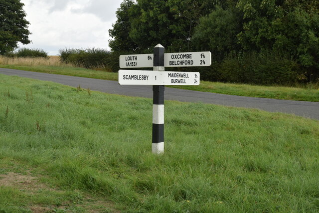
///cadet.jaundice.demotion. Near Burwell, Lincolnshire

Related Wikis

Oxcombe

Oxcombe is a small village in the civil parish of Maidenwell, in the East Lindsey district of Lincolnshire, England. It is situated 3 miles (5 km) west...

Farforth

Farforth or Farforth-cum-Maidenwell is a hamlet in the East Lindsey district of Lincolnshire, England. It is in the civil parish of Maidenwell, and approximately...

Juicetrump Hill

Juicetrump Hill is a hill around half a mile north of Belchford and 4.5 miles north-east of Horncastle in Lincolnshire, UK within the Lincolnshire Wolds...

Cawkwell

Cawkwell is a hamlet and former civil parish, now in the parish of Scamblesby, in the East Lindsey district of Lincolnshire, England. It is situated approximately...

Scamblesby

Scamblesby is a village and civil parish in the East Lindsey district from Lincolnshire, England. It is situated 6 miles (10 km) south-west from Louth...

Maidenwell, Lincolnshire

Maidenwell is a village and civil parish in the East Lindsey district of Lincolnshire, England. The village is 6 miles (10 km) south from Louth. Maidenwell...

Cadwell Park

Cadwell Park is a motor racing circuit in Lincolnshire, England, 5 mi (8.0 km) south of Louth, owned and operated by MotorSport Vision, a business associated...

Belchford

Belchford is a village and civil parish in the East Lindsey district of Lincolnshire, England. The village is situated approximately 4 miles (6 km) north...

Related Videos

The Green Man Bike Night Scramblesby.Flapjack and Beans

Here are some shots of the Bike Night at THE GREEN MAN Scamblesby link below. Bike night a good night 26c going 21 20c ...

Big D Flapjack and Beans Ride to Bike Night "The Green Man" Scramblesby

As it was 26c here in Sunny England I decided to take a ride out to Lincolnshire bike nights.Tonights meet was at The Green Man ...

St OLAVE RUCKLAND MAY 2021 | 30 ಅಡಿ ಉದ್ದದ ಚರ್ಚ್ | SMALLEST CHURCH | UK (ಇಂಗ್ಲೆಂಡ್ ) KANNADA VLOGS

vgavlogs #vgarandom , #vgakannada , #ಬ್ರಿಟನ್, #Halli, #ಹಳ್ಳಿ St Olave church is situated in the picturesque village ...

Nearby Amenities

Located within 500m of 53.285891,-0.051083436
Scotland Barn
Place: farm
Source: Bing
Lat/Long: 53.28348/-0.0475278
Natural: peak
Source: Bing
Lat/Long: 53.2835403/-0.0568371
The data included in this document is from www.openstreetmap.org. The data is made available under ODbL.

Have you been to Scotland Plantation?

Leave your review of Scotland Plantation below (or comments, questions and feedback).