Gray's Wood

Wood, Forest in Hertfordshire St. Albans

England

Gray's Wood

Shops on Station Road, Wheathampstead
Shops on Station Road, Wheathampstead Credit: David Howard

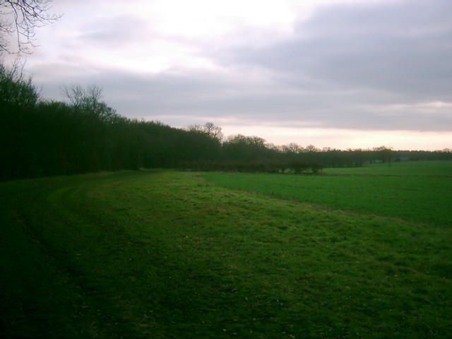
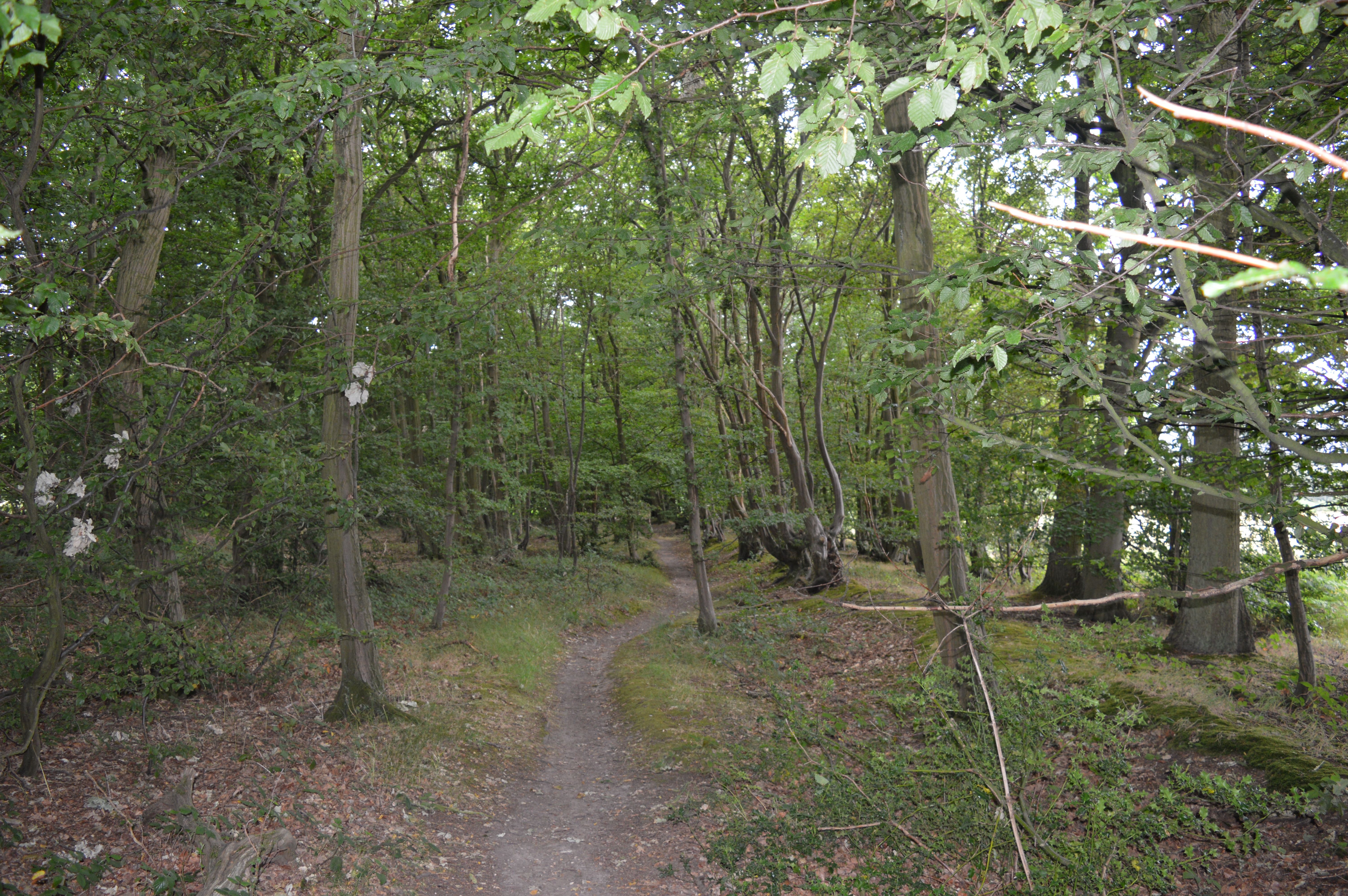
Gray's Wood is a picturesque woodland located in the county of Hertfordshire, England. Spanning over an area of approximately 100 acres, this woodland is a haven for nature enthusiasts and outdoor adventurers alike. The wood is situated in close proximity to the village of Gray's, from which it derives its name.

The woodland boasts a diverse range of tree species, including oak, beech, birch, and pine, creating a vibrant and lush canopy that provides shelter for a variety of wildlife. Visitors to the wood can expect to spot an array of bird species, such as woodpeckers, owls, and thrushes, as well as small mammals like squirrels and hedgehogs.

Gray's Wood offers several walking trails that wind through its enchanting landscape, allowing visitors to explore its natural beauty at their own pace. These trails are well-maintained and marked, making navigation easy for both experienced hikers and casual walkers. Additionally, there are designated picnic areas and benches scattered throughout the wood, providing opportunities for visitors to relax, unwind, and embrace the tranquility of their surroundings.

The wood is open to the public year-round and is a popular destination for families, nature lovers, and dog walkers. It is managed by the local council, which ensures the preservation of its natural habitat and the maintenance of its facilities.

Overall, Gray's Wood is a captivating woodland that offers a peaceful retreat from the hustle and bustle of everyday life, allowing visitors to immerse themselves in the beauty of nature and enjoy the serenity it provides.

If you have any feedback on the listing, please let us know in the comments section below.

Gray's Wood Images

Images are sourced within 2km of 51.811266/-0.26483942 or Grid Reference TL1913. Thanks to Geograph Open Source API. All images are credited.

Shops on Station Road, Wheathampstead
Coleman Green : cottages dated 1877
Coleman Green : John Bunyan's Chimney Grade II listed structure - <span class="nowrap"><a title="https://historicengland.org.uk/listing/the-list/list-entry/1175683?section=official-list-entry" rel="nofollow ugc noopener" href="https://historicengland.org.uk/listing/the-list/list-entry/1175683?section=official-list-entry">Link</a><img style="margin-left:2px;" alt="External link" title="External link - shift click to open in new window" src="https://s1.geograph.org.uk/img/external.png" width="10" height="10"/></span>.
Coleman Green : John Bunyan's Chimney
Grade II listed structure - LinkExternal link.
Waterend Looking North from TL204136 to the ford at Waterend on the River Lea, West of Welwyn Garden City. It's dry, but the water only has to rise a foot or so to flood the road - hence the little footbridge so people can cross without getting their feet wet.
Waterend
Looking North from TL204136 to the ford at Waterend on the River Lea, West of Welwyn Garden City. It's dry, but the water only has to rise a foot or so to flood the road - hence the little footbridge so people can cross without getting their feet wet.
Waterend house The large house just North of the ford (TL204137)
Waterend house
The large house just North of the ford (TL204137)
Greenway bridge Looking South to a bridge at TL209145 which carries the Ayot Greenway - a length of old railway line converted into cycle path and bridleway, covering most of the way from Wheathampstead to Welwyn Garden City.
Greenway bridge
Looking South to a bridge at TL209145 which carries the Ayot Greenway - a length of old railway line converted into cycle path and bridleway, covering most of the way from Wheathampstead to Welwyn Garden City.
Brocket Hall, Lemsford This is the view one gets from the highway.
Brocket Hall, Lemsford
This is the view one gets from the highway.
Road sign to Hill Farm Lane The area was lacking in tangible elements being woods and open fields.
Road sign to Hill Farm Lane
The area was lacking in tangible elements being woods and open fields.
River from Waterend Ford View of the River Lea taken from Waterend Ford looking South-East
River from Waterend Ford
View of the River Lea taken from Waterend Ford looking South-East
Wellhead This is the head mechanism for a well. Largely complete but the cover is missing. Locally made and originally driven by a separate (steam traction?) engine, possibly as a water source for a steam plough? Located near the top of a hill just south of Threegroves Wood. There is a concrete structure about two metres high, possibly for a water tank. TL203148
Wellhead
This is the head mechanism for a well. Largely complete but the cover is missing. Locally made and originally driven by a separate (steam traction?) engine, possibly as a water source for a steam plough? Located near the top of a hill just south of Threegroves Wood. There is a concrete structure about two metres high, possibly for a water tank. TL203148
Open land near Long Grove Plantation The photograph is taken just south of Upper Cromer Hyde Farm looking south towards long grove plantation. The plantation straddles TL2012 and TL2011
Open land near Long Grove Plantation
The photograph is taken just south of Upper Cromer Hyde Farm looking south towards long grove plantation. The plantation straddles TL2012 and TL2011
Stockings Spring Woods Off Codicote Road, Wheathampstead, nestling amongst the wooded estates of central Hertfordshire, this small wood is a beautiful example of traditional coppice management and its value to wildlife. 
Coppiced hornbeam woodlands were once typical of Hertfordshire. At Stocking Springs Wood gnarled and twisted trees, previously coppiced, throw a dense shade.
Stockings Spring Woods
Off Codicote Road, Wheathampstead, nestling amongst the wooded estates of central Hertfordshire, this small wood is a beautiful example of traditional coppice management and its value to wildlife. Coppiced hornbeam woodlands were once typical of Hertfordshire. At Stocking Springs Wood gnarled and twisted trees, previously coppiced, throw a dense shade.
Sunset over The Ayots
Public bridleway, leading to Waterend Lane
Water End Farm House, Sandridge/Wheathampstead Water End was originally part of the Manor and Parish of Sandridge, but was closer to Ayot St Peter and is now part of the Parish of Wheathampstead.
The house was built in about 1610 by Sir John Jennings, although the large barn on the site (now moved to St Albans <span class="nowrap"><a title="http://www.clickonhertfordshire.co.uk/waterend.htm" rel="nofollow ugc noopener" href="http://www.clickonhertfordshire.co.uk/waterend.htm">Link</a><img style="margin-left:2px;" alt="External link" title="External link - shift click to open in new window" src="https://s1.geograph.org.uk/img/external.png" width="10" height="10"/></span> ) suggests there was a farm here before that. In 1660 Sarah Jennings was born here, and later married John Churchill – and as a result of her husband's successful career moved into a newly built and much more impressive residence. Can you guess where that was before clicking on the <span class="nowrap"><a title="http://www.blenheimpalace.com/" rel="nofollow ugc noopener" href="http://www.blenheimpalace.com/">Link</a><img style="margin-left:2px;" alt="External link" title="External link - shift click to open in new window" src="https://s1.geograph.org.uk/img/external.png" width="10" height="10"/></span> ?
See <span class="nowrap"><a title="http://www.hertfordshire-genealogy.co.uk/data/places/places-s/sandridge-water-end.htm" rel="nofollow ugc noopener" href="http://www.hertfordshire-genealogy.co.uk/data/places/places-s/sandridge-water-end.htm">Link</a><img style="margin-left:2px;" alt="External link" title="External link - shift click to open in new window" src="https://s1.geograph.org.uk/img/external.png" width="10" height="10"/></span>  for information on the farm in the 19th century – including some earlier pictures.
Water End Farm House, Sandridge/Wheathampstead
Water End was originally part of the Manor and Parish of Sandridge, but was closer to Ayot St Peter and is now part of the Parish of Wheathampstead. The house was built in about 1610 by Sir John Jennings, although the large barn on the site (now moved to St Albans LinkExternal link ) suggests there was a farm here before that. In 1660 Sarah Jennings was born here, and later married John Churchill – and as a result of her husband's successful career moved into a newly built and much more impressive residence. Can you guess where that was before clicking on the LinkExternal link ? See LinkExternal link for information on the farm in the 19th century – including some earlier pictures.
Footpath to Flint Bridge Footpath to Flint Bridge in the Flint Bridge Plantation
Footpath to Flint Bridge
Footpath to Flint Bridge in the Flint Bridge Plantation
Flint Bridge Plantation Parking Flint Bridge Plantation parking by Marford Road (B653)
Flint Bridge Plantation Parking
Flint Bridge Plantation parking by Marford Road (B653)
Show me another place!

Gray's Wood is located at Grid Ref: TL1913 (Lat: 51.811266, Lng: -0.26483942)

Administrative County: Hertfordshire

District: St. Albans

Police Authority: Hertfordshire

What 3 Words

///bunch.enhancement.accent. Near Wheathampstead, Hertfordshire

Nearby Locations

David's Dingle Gray's Wood

Related Wikis

Devil's Dyke, Hertfordshire

Devil's Dyke is the remains of a prehistoric defensive ditch which lies at the east side of the village of Wheathampstead, Hertfordshire, England. It is...

Stocking Springs Wood

Stocking Springs Wood is a 1.1-hectare (2.7-acre) nature reserve between Ayot St Lawrence and Ayot St Peter in Welwyn Hatfield district in Hertfordshire...

Brocket Hall

Brocket Hall is a neo-classical country house set in a large park at the western side of the urban area of Welwyn Garden City in Hertfordshire, England...

Wheathampstead

Wheathampstead is a village and civil parish in Hertfordshire, England, north of St Albans. The population of the ward at the 2001 census was 6,058. Included...

Wheathampstead railway station

Wheathampstead railway station was a railway station serving Wheathampstead on the Great Northern Railway branch line to Dunstable. While little of it...

Ayot Green

Ayot Green is a hamlet in Hertfordshire, England and is near the A1(M) Motorway, close to Welwyn Garden City. It is a typical traditional English village...

St Helen's Church, Wheathampstead

St Helen's Church is the oldest church in Wheathampstead, Hertfordshire, England, although the date of its origins is unknown. The wooden Anglo-Saxon structure...

Ayot St Peter

Ayot St Peter is a village and civil parish in the Welwyn Hatfield district of Hertfordshire, England, about two miles north-west of Welwyn Garden City...

Nearby Amenities

Located within 500m of 51.811266,-0.26483942
Barrier: kissing_gate
Bicycle: no
Foot: yes
Source: GPS, observation
Lat/Long: 51.8135876/-0.2705433
Bus Stop
Waterend Lane
Bench: no
Bin: no
Naptan AtcoCode: 210021510220
Naptan Bearing: NW
Naptan CommonName: Waterend Lane
Naptan Crossing: Coleman Green Lane
Naptan Indicator: opp
Naptan Landmark: Coleman Green Lane
Naptan NaptanCode: hrtatmgw
Naptan ShortCommonName: NA
Naptan Street: Marford Road
Naptan Verified: no
Public Transport: platform
Shelter: no
Source: naptan_import
Lat/Long: 51.8073509/-0.2620537
Leisure: picnic_table
Lat/Long: 51.814809/-0.2614242
Leisure: picnic_table
Lat/Long: 51.8148759/-0.2616244
The data included in this document is from www.openstreetmap.org. The data is made available under ODbL.

Have you been to Gray's Wood?

Leave your review of Gray's Wood below (or comments, questions and feedback).