Kiln Copse

Wood, Forest in Sussex Horsham

England

Kiln Copse

Downs Link, near Slinfold A view of the Downs Link path as it approaches Slinfold in West Sussex.  The path follows a dismantled railway line.  It also forms part of route 223 of the National Cycle Network.

Here, a public footpath crosses the Downs Link path.
Downs Link, near Slinfold Credit: Malc McDonald

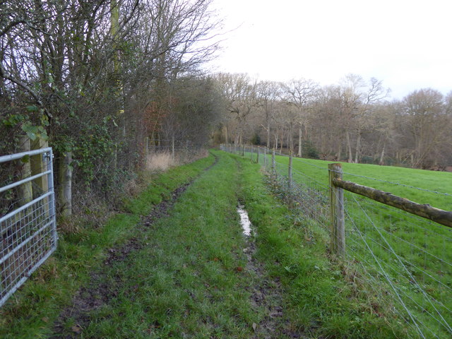
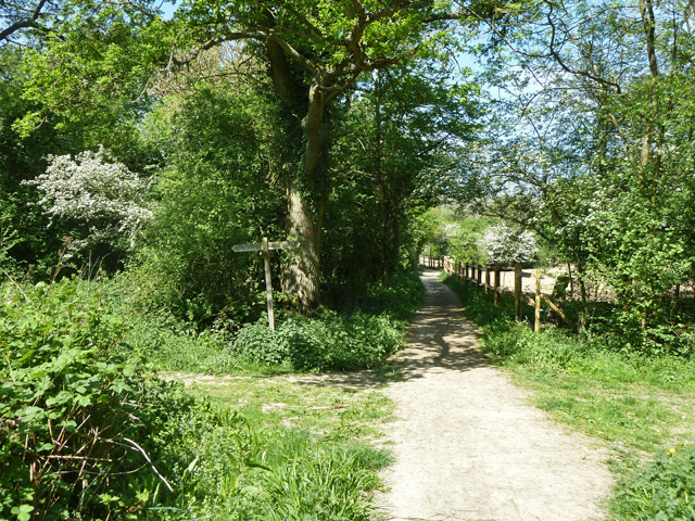
Kiln Copse is a picturesque woodland located in Sussex, England. Situated in the heart of the South Downs National Park, this forested area covers approximately 100 acres of land. The copse is primarily composed of a mix of deciduous and coniferous trees, creating a diverse and vibrant ecosystem.

The woodland is known for its tranquil atmosphere and beautiful scenery, making it a popular destination for nature lovers and outdoor enthusiasts. Walking trails wind through the copse, allowing visitors to explore its natural wonders at their own pace. The pathways are well-maintained, making them accessible to people of all ages and abilities.

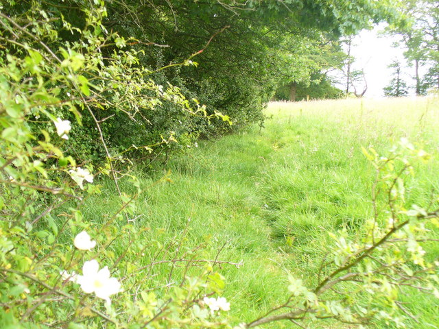
Within the copse, there is a small stream that meanders through the trees, adding to the serenity of the environment. The stream is home to a variety of aquatic species, including small fish and amphibians, which can be observed by those who take a moment to sit by its banks.

Wildlife is abundant in Kiln Copse, with many species calling this forest their home. Visitors may spot deer, foxes, and various bird species, including woodpeckers and owls. The copse also provides a habitat for a wide range of flora, including bluebells, ferns, and mosses, which create a vibrant and colorful display during the spring and summer months.

Overall, Kiln Copse offers a serene and enchanting experience for those seeking a connection with nature. Its diverse ecosystem, well-maintained trails, and abundant wildlife make it a must-visit destination for anyone looking to explore the natural beauty of Sussex.

If you have any feedback on the listing, please let us know in the comments section below.

Kiln Copse Images

Images are sourced within 2km of 51.089507/-0.41120786 or Grid Reference TQ1133. Thanks to Geograph Open Source API. All images are credited.

Downs Link, near Slinfold A view of the Downs Link path as it approaches Slinfold in West Sussex.  The path follows a dismantled railway line.  It also forms part of route 223 of the National Cycle Network.

Here, a public footpath crosses the Downs Link path.
Downs Link, near Slinfold
A view of the Downs Link path as it approaches Slinfold in West Sussex. The path follows a dismantled railway line. It also forms part of route 223 of the National Cycle Network. Here, a public footpath crosses the Downs Link path.
Enclosed path to woodland west of Hyes
Path junction near Godley's Cottage Ways to Rudgwick left, Rowhook right, and Cox Green straight on.
Path junction near Godley's Cottage
Ways to Rudgwick left, Rowhook right, and Cox Green straight on.
Bridleway towards Cox Green West Sussex path 1395.
Bridleway towards Cox Green
West Sussex path 1395.
Bluebells in Godley's Copse
Footpath across rape field Used by the Sussex Border Path, according to the map, although there is a shorter bridleway over this section that runs exactly along the border - perhaps thought too muddy in winter?
Footpath across rape field
Used by the Sussex Border Path, according to the map, although there is a shorter bridleway over this section that runs exactly along the border - perhaps thought too muddy in winter?
Looking westwards along the A281 at Smithers Farm The A281 is a 36 mile long northwest-southeast road in southern England that passes through the countryside between Guildford, Surrey and Pyecombe, West Sussex near Brighton.
<span class="nowrap"><a title="http://www.sabre-roads.org.uk/wiki/index.php?title=A281" rel="nofollow ugc noopener" href="http://www.sabre-roads.org.uk/wiki/index.php?title=A281">Link</a><img style="margin-left:2px;" alt="External link" title="External link - shift click to open in new window" src="https://s1.geograph.org.uk/img/external.png" width="10" height="10"/></span>
Looking westwards along the A281 at Smithers Farm
The A281 is a 36 mile long northwest-southeast road in southern England that passes through the countryside between Guildford, Surrey and Pyecombe, West Sussex near Brighton. LinkExternal link
Street Copse On the Sussex Border Path near Rudgwick.
Street Copse
On the Sussex Border Path near Rudgwick.
Bluebells in Street Copse Viewed from beside the Sussex Border Path.
Bluebells in Street Copse
Viewed from beside the Sussex Border Path.
Hedgerow by Godley's Copse Blooming wild roses supply a splash of colour against the midsummer green of the Weald.
Hedgerow by Godley's Copse
Blooming wild roses supply a splash of colour against the midsummer green of the Weald.
Godley's Copse Deciduous woodland with light undergrowth in the West Sussex Weald near Rudgwick.
Godley's Copse
Deciduous woodland with light undergrowth in the West Sussex Weald near Rudgwick.
Development by Rudgwick Housing development by Gravatt's Farm, Rudgwick which retains a vernacular look. The field is pastureland.
Development by Rudgwick
Housing development by Gravatt's Farm, Rudgwick which retains a vernacular look. The field is pastureland.
Rural Redevelopment New housing with a distinct Wealden Hall-house look to it, Gravatt's Farm, Rudgwick.
Rural Redevelopment
New housing with a distinct Wealden Hall-house look to it, Gravatt's Farm, Rudgwick.
Godley's Copse near Rudgwick
Footpath junction with bridleway to Gravatt's Farm
Owl nesting box near Gravatt's Farm
Offset footpath junction on the Downs Link The right hand path leads to Warhams and the left to Violets Farm
Offset footpath junction on the Downs Link
The right hand path leads to Warhams and the left to Violets Farm
Surface spring or sinkhole? This natural looking hole has appeared, I think, as a result of an underground spring coming to the surface due to a blockage, then returning underground again. A similar occurrence happened at my father's house twice over a period of 40 years after heavy rain.
Surface spring or sinkhole?
This natural looking hole has appeared, I think, as a result of an underground spring coming to the surface due to a blockage, then returning underground again. A similar occurrence happened at my father's house twice over a period of 40 years after heavy rain.
Show me another place!

Kiln Copse is located at Grid Ref: TQ1133 (Lat: 51.089507, Lng: -0.41120786)

Administrative County: West Sussex

District: Horsham

Police Authority: Sussex

What 3 Words

///haggling.spending.handyman. Near Slinfold, West Sussex

Related Wikis

Slinfold Stream and Quarry

Slinfold Stream and Quarry is a 2.3-hectare (5.7-acre) geological Site of Special Scientific Interest west of Horsham in West Sussex. It is a Geological...

Slinfold

Slinfold is a village and civil parish in the Horsham District of West Sussex, England. == Geography == The village is almost 4 miles (6.4 km) west of...

Holy Trinity Church, Rudgwick

Holy Trinity Church is the Anglican parish church of Rudgwick, a village in the Horsham district of West Sussex, England. The oldest part of the church...

Slinfold railway station

Slinfold railway station was on the Cranleigh Line and served the village of Slinfold in West Sussex. == History == The line had a single track and opened...

Rudgwick

Rudgwick is a village and civil parish in the Horsham District of West Sussex, England. The village is 6 miles (10 km) west from Horsham on the north...

High Weald AONB

The High Weald Area of Outstanding Natural Beauty is in south-east England. Covering an area of 1,450 square kilometres (560 sq mi), it takes up parts...

Rudgwick railway station

Rudgwick railway station was on the Cranleigh Line. It served the village of Rudgwick in West Sussex until June, 1965. == History == Rudgwick station opened...

Stane Street (Chichester)

Stane Street is the modern name of the 91 km-long (57 mi) Roman road in southern England that linked Londinium (London) to Noviomagus Reginorum (Chichester...

Nearby Amenities

Located within 500m of 51.089507,-0.41120786
Guildford Road
Naptan AtcoCode: 4400HR1093;4400HR1094
Naptan Bearing: NE;SW
Naptan BusStopType: CUS
Naptan CommonName: Guildford Road
Naptan Indicator: HAR
Naptan Landmark: Hail & Ride
Naptan NaptanCode: wsxgdjpd;wsxgdjpg
Naptan Street: Guildford Road
Naptan Verified: no
Source: naptan_import
Lat/Long: 51.0872371/-0.4102039
Lodge Farm
Place: isolated_dwelling
Lat/Long: 51.0909367/-0.4081535
Bench
Lat/Long: 51.0932957/-0.4092174
The data included in this document is from www.openstreetmap.org. The data is made available under ODbL.

Have you been to Kiln Copse?

Leave your review of Kiln Copse below (or comments, questions and feedback).