Aberdulais

Settlement in Glamorgan

Wales

Aberdulais

Red tin tabernacle, Cilfrew Red painted corrugated iron clad chapel/school room with ‘ecclesiastic’ Gothic style fenestration and small entrance porch.
Red tin tabernacle, Cilfrew Credit: Alan Hughes

Aberdulais is a small village located in the county of Glamorgan, Wales. Situated on the River Neath, it lies approximately 8 miles northeast of the town of Neath and 10 miles south of the city of Swansea. The village is known for its picturesque setting and rich industrial history.

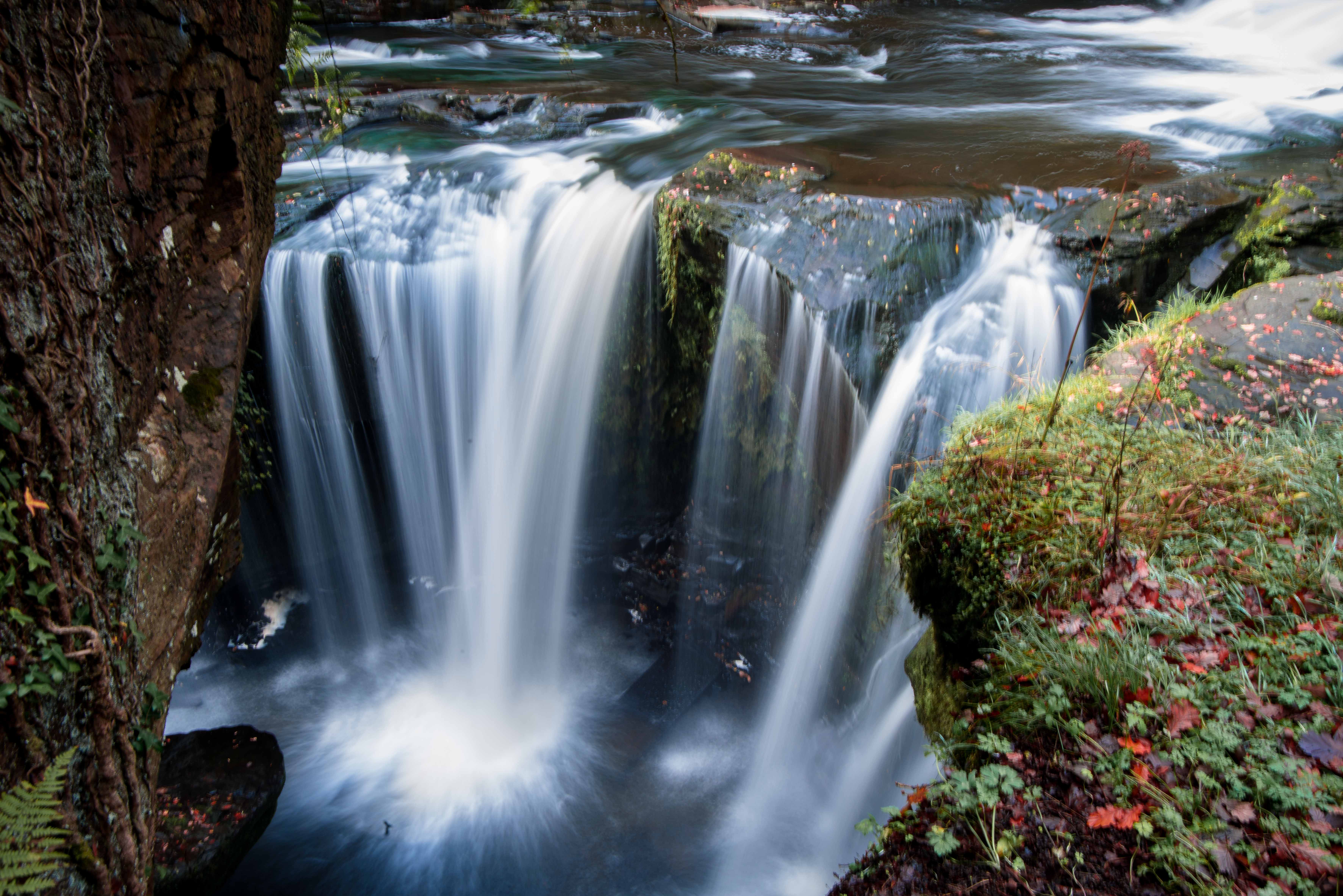
One of the main attractions in Aberdulais is the Aberdulais Falls, a series of cascading waterfalls that have been used for industrial purposes since the 16th century. The falls were once a vital source of power for local industries, including ironworks, tinplate works, and a cotton factory. Today, the falls are managed by the National Trust and offer visitors the opportunity to explore the industrial heritage of the area.

Another notable feature of Aberdulais is the Aberdulais Tin Works and Waterwheel. This historic site showcases the remains of a 19th-century tinplate works, including a fully restored waterwheel that was once used to power the machinery. Visitors can learn about the tinplate industry and its significance in the local economy.

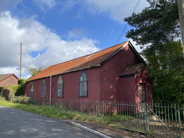
The village itself is quiet and charming, with a mix of traditional Welsh architecture and modern developments. It has a few local amenities, including a small convenience store, a primary school, and a village hall. The surrounding countryside offers opportunities for outdoor activities such as hiking, cycling, and fishing.

Overall, Aberdulais is a hidden gem in Glamorgan, offering visitors a glimpse into its industrial past and a chance to enjoy the natural beauty of the area.

If you have any feedback on the listing, please let us know in the comments section below.

Aberdulais Images

Images are sourced within 2km of 51.682424/-3.774221 or Grid Reference SS7799. Thanks to Geograph Open Source API. All images are credited.

Red tin tabernacle, Cilfrew Red painted corrugated iron clad chapel/school room with ‘ecclesiastic’ Gothic style fenestration and small entrance porch.
Red tin tabernacle, Cilfrew
Red painted corrugated iron clad chapel/school room with ‘ecclesiastic’ Gothic style fenestration and small entrance porch.
Ordnance Survey Rivet This OS rivet can be found on a stone north side of the path. It marks a point 116.940m above mean sea level.
Ordnance Survey Rivet
This OS rivet can be found on a stone north side of the path. It marks a point 116.940m above mean sea level.
Ordnance Survey Rivet This OS rivet can be found on a rock outcrop west side of the path. It marks a point 149.739m above mean sea level.
Ordnance Survey Rivet
This OS rivet can be found on a rock outcrop west side of the path. It marks a point 149.739m above mean sea level.
Ordnance Survey Cut Mark This OS cutmark can be found on a stone south side of the path. It marks a point 161.398m above mean sea level.
Ordnance Survey Cut Mark
This OS cutmark can be found on a stone south side of the path. It marks a point 161.398m above mean sea level.
Ordnance Survey Rivet This OS rivet can be found on a rock south side of the path. It marks a point 180.213m above mean sea level.
Ordnance Survey Rivet
This OS rivet can be found on a rock south side of the path. It marks a point 180.213m above mean sea level.
Ordnance Survey Rivet This OS rivet can be found at the base of the wall NE side of the road. It marks a point 201.491m above mean sea level.
Ordnance Survey Rivet
This OS rivet can be found at the base of the wall NE side of the road. It marks a point 201.491m above mean sea level.
Ordnance Survey Cut Mark This OS cut mark can be found on the NE angle of the Tabor Chapel. It marks a point 153.055m above mean sea level.
Ordnance Survey Cut Mark
This OS cut mark can be found on the NE angle of the Tabor Chapel. It marks a point 153.055m above mean sea level.
Ordnance Survey Cut Mark This OS cut mark can be found on the east parapet of the bridge. It marks a point 136.127m above mean sea level.
Ordnance Survey Cut Mark
This OS cut mark can be found on the east parapet of the bridge. It marks a point 136.127m above mean sea level.
Lletty'r Afel Farm
Lletty'r Afel Farm
Gelli-march Farm Near Neath Golf Club
Gelli-march Farm
Near Neath Golf Club
The entrance to Sarn Helen Roman Road from the B4242 Hidden in the shadows is the signposted entrance to the Roman Road that is categorised as a 'byway open to all traffic' despite its historic significance.
The entrance to Sarn Helen Roman Road from the B4242
Hidden in the shadows is the signposted entrance to the Roman Road that is categorised as a 'byway open to all traffic' despite its historic significance.
Railway viaduct over the River Dulais Viaduct carrying the former 'Neath & Brecon Railway' and now used to transport coal from the washeries at the top of the Dulais Valley.
Railway viaduct over the River Dulais
Viaduct carrying the former 'Neath & Brecon Railway' and now used to transport coal from the washeries at the top of the Dulais Valley.
Tabor Chapel (built 1866) near Cilfrew
Old mine chimney near Ty Draw Farm I assume this was an air vent. As with <a href="https://www.geograph.org.uk/photo/1048317">SS6094 : Air shaft at former mine south of Waunarlwydd</a> holes have been knocked in at the base, presumably to allow the shaft beneath to be filled in.
Old mine chimney near Ty Draw Farm
I assume this was an air vent. As with SS6094 : Air shaft at former mine south of Waunarlwydd holes have been knocked in at the base, presumably to allow the shaft beneath to be filled in.
Ruins of mine above Ty Draw farm The view is along the south wall of a building and it is the only wall still standing.
Ruins of mine above Ty Draw farm
The view is along the south wall of a building and it is the only wall still standing.
Detached houses at the northern end of Rosser Terrace, Cilfrew Two detached houses located between Rosser Terrace and New Road, Cilfrew.
Detached houses at the northern end of Rosser Terrace, Cilfrew
Two detached houses located between Rosser Terrace and New Road, Cilfrew.
New Road, Cilfrew Viewed across Main Road.
New Road, Cilfrew
Viewed across Main Road.
New Road houses, Cilfrew Viewed from the Main Road end.
New Road houses, Cilfrew
Viewed from the Main Road end.
Show me another place!

Aberdulais is located at Grid Ref: SS7799 (Lat: 51.682424, Lng: -3.774221)

Unitary Authority: Neath Port Talbot

Police Authority: South Wales

What 3 Words

///awards.stews.sport. Near Neath, Neath Port Talbot

Related Wikis

Aberdulais

Aberdulais is a village and electoral ward in Neath Port Talbot, Wales, lying on the River Neath, in the community of Blaenhonddan. The village grew...

Aberdulais Falls

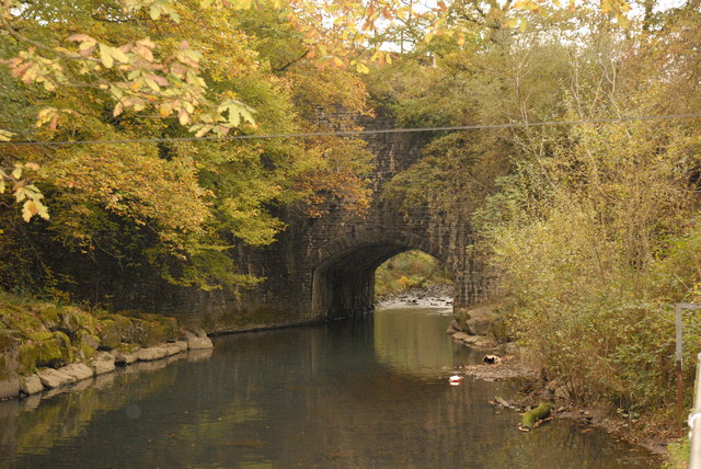
The Aberdulais Falls are found on the River Dulais at Aberdulais, near Neath in the county borough of Neath Port Talbot, Wales. The falls are formed as...

River Dulais

River Dulais (Welsh: Afon Dulais) is a river of Wales which has its source at Mynydd y Drum. It joins the River Neath after flowing over Aberdulais Falls...

Aberdylais Halt railway station

Aberdylais halt railway station served the village of Aberdulais in Wales. It was located on the line from Neath to Merthyr Tydfil. == History == Opened...

Penscynor Wildlife Park

Penscynor Wildlife Park was a wildlife and safari park located near Neath in South Wales. == History == In 1966, Neath builder Idris Hale bought the semi...

Cilfrew railway station

Cilfrew railway station served the village of Cilfrew, in the historical county of Glamorgan, Wales, from 1888 to 1962 on the Neath and Brecon Railway...

Tonna Hospital

Tonna Hospital (Welsh: Ysbyty Tonna) is a psychiatric hospital in Tonna, Neath, Wales. It is managed by Swansea Bay University Health Board. == History... ==

Tonna, Neath

Tonna (Welsh: Tonnau) is the name of a village and community in Neath Port Talbot, Wales, located to the north-east of Neath. Immediately between Tonna...

Nearby Amenities

Located within 500m of 51.682424,-3.774221
Cafe
Lat/Long: 51.6800792/-3.7775811
Bus Stop
Aberdulais Falls
Bus: yes
Public Transport: platform
Lat/Long: 51.679682/-3.7779715
Fixme: continue
Lat/Long: 51.6811414/-3.7692428
Place Of Worship
Religion: christian
Lat/Long: 51.6822627/-3.7750789
Traffic Signals
Traffic Signals Direction: both
Lat/Long: 51.6797397/-3.7776361
Post Box
Post Box Type: lamp
Ref: SA10 86D
Royal Cypher: EIIR
Royal Cypher Wikidata: Q33102113
Lat/Long: 51.6800123/-3.7774448
Give Way
Direction: forward
Lat/Long: 51.6782113/-3.7763996
Give Way
Direction: backward
Lat/Long: 51.6781391/-3.7763554
Direction: 125
Generator Method: photovoltaic
Generator Output Electricity: yes
Generator Solar Modules: 11
Generator Source: solar
Generator Type: solar_photovoltaic_panel
Location: roof
Power: generator
Lat/Long: 51.6800547/-3.7798145
Direction: SSE
Generator Method: photovoltaic
Generator Output Electricity: yes
Generator Solar Modules: 6
Generator Source: solar
Generator Type: solar_photovoltaic_panel
Location: roof
Power: generator
Lat/Long: 51.678907/-3.7738312
Direction: WSW
Generator Method: photovoltaic
Generator Output Electricity: yes
Generator Solar Modules: 7
Generator Source: solar
Generator Type: solar_photovoltaic_panel
Location: roof
Power: generator
Lat/Long: 51.6789687/-3.7738922
Direction: 265
Generator Method: photovoltaic
Generator Output Electricity: yes
Generator Solar Modules: 10
Generator Source: solar
Generator Type: solar_photovoltaic_panel
Location: roof
Power: generator
Lat/Long: 51.682761/-3.7755996
Direction: 265
Generator Method: photovoltaic
Generator Output Electricity: yes
Generator Solar Modules: 7
Generator Source: solar
Generator Type: solar_photovoltaic_panel
Location: roof
Power: generator
Lat/Long: 51.6821819/-3.7755129
Direction: 175
Generator Method: photovoltaic
Generator Output Electricity: yes
Generator Solar Modules: 10
Generator Source: solar
Generator Type: solar_photovoltaic_panel
Location: roof
Power: generator
Lat/Long: 51.6839434/-3.7752459
Direction: 215
Generator Method: photovoltaic
Generator Output Electricity: yes
Generator Solar Modules: 16
Generator Source: solar
Generator Type: solar_photovoltaic_panel
Location: roof
Power: generator
Lat/Long: 51.6802389/-3.78004
Direction: SE
Generator Method: photovoltaic
Generator Output Electricity: yes
Generator Solar Modules: 16
Generator Source: solar
Generator Type: solar_photovoltaic_panel
Location: roof
Power: generator
Lat/Long: 51.6816793/-3.7748226
Direction: 175
Generator Method: photovoltaic
Generator Output Electricity: yes
Generator Solar Modules: 6
Generator Source: solar
Generator Type: solar_photovoltaic_panel
Location: roof
Power: generator
Lat/Long: 51.682158/-3.7754757
Direction: 85
Generator Method: photovoltaic
Generator Output Electricity: yes
Generator Solar Modules: 3
Generator Source: solar
Generator Type: solar_photovoltaic_panel
Location: roof
Power: generator
Lat/Long: 51.6839345/-3.775337
Direction: 175
Generator Method: photovoltaic
Generator Output Electricity: yes
Generator Solar Modules: 12
Generator Source: solar
Generator Type: solar_photovoltaic_panel
Location: roof
Power: generator
Lat/Long: 51.6818512/-3.7756836
Direction: 175
Generator Method: photovoltaic
Generator Output Electricity: yes
Generator Solar Modules: 16
Generator Source: solar
Generator Type: solar_photovoltaic_panel
Location: roof
Power: generator
Lat/Long: 51.6816631/-3.7759304
Direction: 85
Generator Method: photovoltaic
Generator Output Electricity: yes
Generator Solar Modules: 5
Generator Source: solar
Generator Type: solar_photovoltaic_panel
Location: roof
Power: generator
Lat/Long: 51.6818823/-3.7756376
Direction: 85
Generator Method: photovoltaic
Generator Output Electricity: yes
Generator Solar Modules: 3
Generator Source: solar
Generator Type: solar_photovoltaic_panel
Location: roof
Power: generator
Lat/Long: 51.6839724/-3.7753435
Direction: 85
Generator Method: photovoltaic
Generator Output Electricity: yes
Generator Solar Modules: 10
Generator Source: solar
Generator Type: solar_photovoltaic_panel
Location: roof
Power: generator
Lat/Long: 51.6827644/-3.7755365
Direction: S
Generator Method: photovoltaic
Generator Output Electricity: yes
Generator Solar Modules: 24
Generator Source: solar
Generator Type: solar_photovoltaic_panel
Location: roof
Power: generator
Lat/Long: 51.6817419/-3.7760856
Bus Stop
Dulais Drive
Bus: yes
Public Transport: platform
Lat/Long: 51.6814359/-3.7751354
Bus Stop
Dulais Drive
Bus: yes
Public Transport: platform
Lat/Long: 51.6811848/-3.7753259
Bus Stop
Aberdulais Falls
Bus: yes
Public Transport: platform
Lat/Long: 51.6790043/-3.77846
Man Made: watermill
Lat/Long: 51.6810277/-3.7781144
Man Made: chimney
Lat/Long: 51.6807769/-3.7782476
The data included in this document is from www.openstreetmap.org. The data is made available under ODbL.

Have you been to Aberdulais?

Leave your review of Aberdulais below (or comments, questions and feedback).