The Common

Wood, Forest in Warwickshire Warwick

England

The Common

The Green Man public house, Kenilworth
The Green Man public house, Kenilworth Credit: Ian S

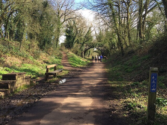
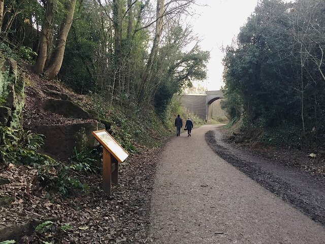
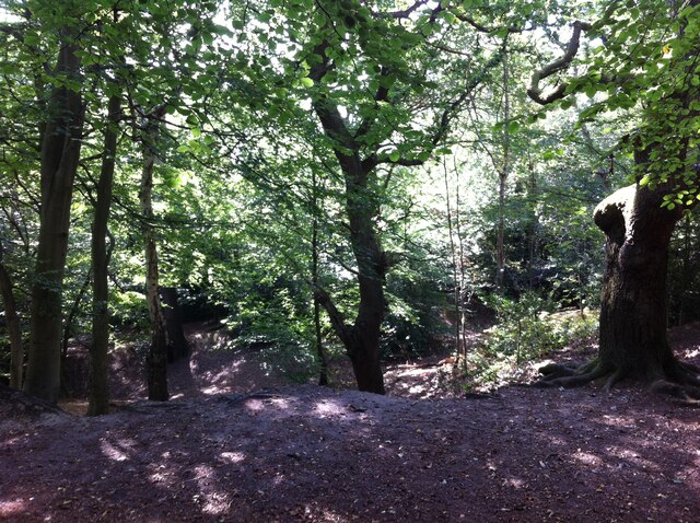
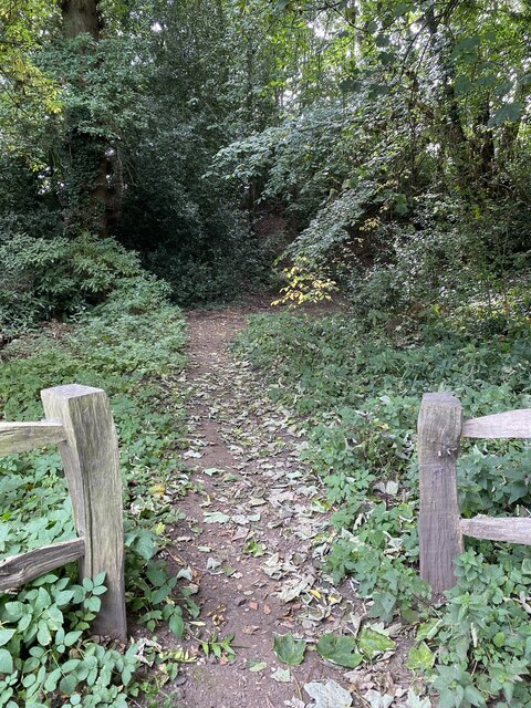
The Common, located in Warwickshire, is a woodland area known for its natural beauty and diverse flora and fauna. Covering an expansive area, The Common is a popular destination for nature enthusiasts, hikers, and wildlife photographers.

The woodland is characterized by a mix of deciduous and coniferous trees, including oak, beech, pine, and birch. The dense canopy provides shelter for a variety of bird species, such as woodpeckers, thrushes, and owls. Small mammals like squirrels, rabbits, and hedgehogs can also be spotted among the undergrowth.

The Common offers a network of well-maintained trails that wind through the woods, providing visitors with opportunities for leisurely walks or more challenging hikes. Along the trails, visitors can enjoy the serene ambiance of the forest, with sunlight filtering through the branches and the sound of birdsong filling the air.

For those interested in botany, The Common is home to a wide range of plant species. Wildflowers, ferns, and mosses can be found carpeting the forest floor, while lichens and fungi cling to tree trunks. The changing seasons bring a vibrant display of colors, with autumn foliage creating a stunning backdrop for photography enthusiasts.

The Common is a cherished natural treasure in Warwickshire, offering a peaceful escape from the hustle and bustle of daily life. Visitors can immerse themselves in the tranquility of the woodland, appreciating the beauty of nature and the abundance of wildlife that call this place home.

If you have any feedback on the listing, please let us know in the comments section below.

The Common Images

Images are sourced within 2km of 52.354317/-1.5648593 or Grid Reference SP2973. Thanks to Geograph Open Source API. All images are credited.

The Green Man public house, Kenilworth
Clarke's Avenue, Kenilworth
East on Kenilworth Greenway, Crackley The Greenway, a County Council amenity, follows the route of the former Kenilworth-Berkswell railway line. Here it is crossed by and connected to a public footpath, a track at this point, between north Kenilworth and south Coventry.
East on Kenilworth Greenway, Crackley
The Greenway, a County Council amenity, follows the route of the former Kenilworth-Berkswell railway line. Here it is crossed by and connected to a public footpath, a track at this point, between north Kenilworth and south Coventry.
Making a deck, The Engine public house, Mill End, Kenilworth In the later phase of the pandemic, pubs that had had to close invested in creating outdoor space so that they could safely serve socially-distanced patrons.
Making a deck, The Engine public house, Mill End, Kenilworth
In the later phase of the pandemic, pubs that had had to close invested in creating outdoor space so that they could safely serve socially-distanced patrons.
Kenilworth Greenway turns south, Crackley, Kenilworth The Greenway was created on a former railway line. The information board has accounts of the Kenilworth Sandstone, exposed here, and of the railway.
Kenilworth Greenway turns south, Crackley, Kenilworth
The Greenway was created on a former railway line. The information board has accounts of the Kenilworth Sandstone, exposed here, and of the railway.
Odibourne Allotments, Manor Road, Kenilworth The allotments were open to the public for the Heritage Open Days 2021 and Edible England events; members of the Kenilworth Allotment Tenants' Association (KATA) can be seen welcoming visitors. 

The Odibourne site was established in 1919, when Kenilworth Urban District Council bought land from the estate of the deceased William Thomas Pears. The council had recently decided to build on the 'Noah's Ark' allotments nearby, but was obliged under the 1908 Smallholding & Allotments Act to provide sufficient land for local people who wanted plots for growing food. The site is owned today by Kenilworth Town Council, but has been managed since 1983 by KATA (information taken from a notice board on the site).
Odibourne Allotments, Manor Road, Kenilworth
The allotments were open to the public for the Heritage Open Days 2021 and Edible England events; members of the Kenilworth Allotment Tenants' Association (KATA) can be seen welcoming visitors. The Odibourne site was established in 1919, when Kenilworth Urban District Council bought land from the estate of the deceased William Thomas Pears. The council had recently decided to build on the 'Noah's Ark' allotments nearby, but was obliged under the 1908 Smallholding & Allotments Act to provide sufficient land for local people who wanted plots for growing food. The site is owned today by Kenilworth Town Council, but has been managed since 1983 by KATA (information taken from a notice board on the site).
Plot 58a, Odibourne Allotments, Kenilworth These allotments, which to this city dweller appear impossibly idyllic, were open to the public for the Heritage Open Days 2021. Behind the idyll, of course, lies hard work and long term commitment, the challenge of group politics, the uncertainty of the weather and the threat, even here, of theft and vandalism. The Odibourne allotments were established in 1919.
Plot 58a, Odibourne Allotments, Kenilworth
These allotments, which to this city dweller appear impossibly idyllic, were open to the public for the Heritage Open Days 2021. Behind the idyll, of course, lies hard work and long term commitment, the challenge of group politics, the uncertainty of the weather and the threat, even here, of theft and vandalism. The Odibourne allotments were established in 1919.
I'm in the Green Zone A scarecrow, probably more decorative than functional, at the Odibourne allotments in Kenilworth, which were open to the public for the Heritage Open Days 2021.
I'm in the Green Zone
A scarecrow, probably more decorative than functional, at the Odibourne allotments in Kenilworth, which were open to the public for the Heritage Open Days 2021.
Apple Pressing at Odibourne Allotments, Kenilworth The allotment site was open to the public as part of the Heritage Open Days 2021 and Edible England events.
Apple Pressing at Odibourne Allotments, Kenilworth
The allotment site was open to the public as part of the Heritage Open Days 2021 and Edible England events.
'My Shed, My Rules' The sheds of the Odibourne Allotments, Kenilworth, are the subject of their own book, 'Odibourne Sheds: rural retreats in a Kenilworth allotment', by Peter James, published by the Bothy Press in 2020.
'My Shed, My Rules'
The sheds of the Odibourne Allotments, Kenilworth, are the subject of their own book, 'Odibourne Sheds: rural retreats in a Kenilworth allotment', by Peter James, published by the Bothy Press in 2020.
The Rules: Water butt on Odibourne Allotments, Kenilworth A water butt and rules governing its use, on the Odibourne Allotments, open to the public for the Heritage Open Days 2021 and Edible England events.
The Rules: Water butt on Odibourne Allotments, Kenilworth
A water butt and rules governing its use, on the Odibourne Allotments, open to the public for the Heritage Open Days 2021 and Edible England events.
Odibourne Allotments, Kenilworth, looking towards Lower Ladyes Hills Not normally open to the public, the allotments were welcoming visitors for the day as part of the Heritage Open Days 2021 and Edible England events. A scarecrow in the form of a Tokyo Olympics mascot can be seen to the right of the picture.
Odibourne Allotments, Kenilworth, looking towards Lower Ladyes Hills
Not normally open to the public, the allotments were welcoming visitors for the day as part of the Heritage Open Days 2021 and Edible England events. A scarecrow in the form of a Tokyo Olympics mascot can be seen to the right of the picture.
Bridge over the Finham Brook, Odibourne Allotments, Kenilworth No doubt flooding is another hazard of allotment life here, but the stream must have enriched the fertility of the valley over the years. Not normally accessible to the public, the allotments were open as part of the Heritage Open Days 2021 and Edible England events.
Bridge over the Finham Brook, Odibourne Allotments, Kenilworth
No doubt flooding is another hazard of allotment life here, but the stream must have enriched the fertility of the valley over the years. Not normally accessible to the public, the allotments were open as part of the Heritage Open Days 2021 and Edible England events.
Lower Ladyes Hills, Kenilworth, seen from the entrance to the Odibourne Allotments The allotments, which were established in the valley of the Finham Brook in 1919, were open to the public as part of the Heritage Open Days.
Lower Ladyes Hills, Kenilworth, seen from the entrance to the Odibourne Allotments
The allotments, which were established in the valley of the Finham Brook in 1919, were open to the public as part of the Heritage Open Days.
Kenilworth Common Once a heath used for grazing farm animals, the common was colonised by birch and oak trees once grazing stopped, and is now a wood with a few remnants of heathland. The land slopes down to the Finham Brook and is crossed by the Coventry to Leamington railway. The common is now a local nature reserve: see the website of the Warwickshire Wildlife Trust here <span class="nowrap"><a title="https://www.warwickshirewildlifetrust.org.uk/reserves/KenilworthCommon" rel="nofollow ugc noopener" href="https://www.warwickshirewildlifetrust.org.uk/reserves/KenilworthCommon">Link</a><img style="margin-left:2px;" alt="External link" title="External link - shift click to open in new window" src="https://s1.geograph.org.uk/img/external.png" width="10" height="10"/></span> .
Kenilworth Common
Once a heath used for grazing farm animals, the common was colonised by birch and oak trees once grazing stopped, and is now a wood with a few remnants of heathland. The land slopes down to the Finham Brook and is crossed by the Coventry to Leamington railway. The common is now a local nature reserve: see the website of the Warwickshire Wildlife Trust here LinkExternal link .
Path to castle earthworks Kenilworth Castle remains.
Path to castle earthworks
Kenilworth Castle remains.
House on Castle Road, Kenilworth B4103 near Kenilworth.
House on Castle Road, Kenilworth
B4103 near Kenilworth.
Gatehouse, Kenilworth Castle
Show me another place!

The Common is located at Grid Ref: SP2973 (Lat: 52.354317, Lng: -1.5648593)

Administrative County: Warwickshire

District: Warwick

Police Authority: Warwickshire

What 3 Words

///herds.gives.handed. Near Kenilworth, Warwickshire

Related Wikis

Nearby Amenities

Located within 500m of 52.354317,-1.5648593
Traffic Signals
Traffic Signals: signal
Traffic Signals Direction: backward
Lat/Long: 52.355807/-1.5633356
Post Box
Collection Times: Mo-Fr 09:00; Sa 07:00
Operator: Royal Mail
Operator Wikidata: Q638098
Post Box Type: pillar
Ref: CV8 395D
Royal Cypher: GVIR
Royal Cypher Wikidata: Q33102169
Source: survey
Lat/Long: 52.3582304/-1.5662434
Barrier: bollard
Bicycle: yes
Foot: yes
Lat/Long: 52.3562348/-1.5656626
Mini Roundabout
Direction: clockwise
Lat/Long: 52.3558829/-1.5684745
Just Tyres
Shop: automotive
Lat/Long: 52.3516725/-1.5696008
Traffic Signals
Traffic Signals: signal
Traffic Signals Direction: forward
Lat/Long: 52.3555284/-1.5624466
Bus Stop
Common Lane
Bench: no
Bin: no
Bus: yes
Covered: no
Lit: yes
Naptan AtcoCode: 4200F030600
Naptan Bearing: NE
Naptan CommonName: Common Lane
Naptan Crossing: Common Lane
Naptan Indicator: Opp
Naptan NaptanCode: waragtjd
Naptan Street: Coventry Road
Naptan Verified: no
Passenger Information Display: no
Public Transport: platform
Shelter: no
Source: naptan_import
Tactile Paving: no
Lat/Long: 52.3574969/-1.5672537
Bus Stop
Forge Road
Bus: yes
Covered: no
Naptan AtcoCode: 4200F106801
Naptan Bearing: E
Naptan CommonName: Forge Road
Naptan Crossing: Forge Road
Naptan Indicator: Adj
Naptan NaptanCode: warapdpa
Naptan Street: Mill End
Naptan Verified: no
Passenger Information Display: no
Public Transport: platform
Source: naptan_import
Lat/Long: 52.3517406/-1.5690571
Bus Stop
Watling Road
Bus: yes
Covered: no
Naptan AtcoCode: 4200F106901
Naptan Bearing: E
Naptan CommonName: Watling Road
Naptan Crossing: Watling Road
Naptan Indicator: Opp
Naptan NaptanCode: warapgjg
Naptan Street: Dalehouse Lane
Naptan Verified: no
Passenger Information Display: no
Public Transport: platform
Shelter: no
Source: naptan_import
Lat/Long: 52.3519981/-1.5664821
Bus Stop
Mill Bank Mews
Bus: yes
Covered: no
Naptan AtcoCode: 4200F106902
Naptan Bearing: W
Naptan CommonName: Mill Bank Mews
Naptan Crossing: Mill Bank Mews
Naptan Indicator: Adj
Naptan NaptanCode: warapgjm
Naptan Street: Mill End
Naptan Verified: no
Passenger Information Display: no
Public Transport: platform
Source: naptan_import
Lat/Long: 52.3518392/-1.5671923
Bus Stop
Knowle Hill
Bus: yes
Covered: no
Naptan AtcoCode: 4200F107001
Naptan Bearing: W
Naptan CommonName: Knowle Hill
Naptan Crossing: Knowle Hill
Naptan Indicator: Adj
Naptan NaptanCode: warapgjp
Naptan Street: Dalehouse Lane
Operator: Stagecoach
Passenger Information Display: no
Public Transport: platform
Route Ref: X17
Shelter: no
Source: naptan_import;survey
Lat/Long: 52.3529552/-1.5606855
Bus Stop
Finham Crescent
Bus: yes
Covered: no
Naptan AtcoCode: 4200F107201
Naptan Bearing: S
Naptan CommonName: Finham Crescent
Naptan Crossing: Finham Crescent
Naptan Indicator: Adj
Naptan NaptanCode: warapgjw
Naptan Street: Finham Road
Naptan Verified: no
Passenger Information Display: no
Public Transport: platform
Source: naptan_import
Lat/Long: 52.3505102/-1.5645178
Bus Stop
Finham Crescent
Bus: yes
Covered: no
Naptan AtcoCode: 4200F107202
Naptan Bearing: N
Naptan CommonName: Finham Crescent
Naptan Crossing: Finham Crescent
Naptan Indicator: Opp
Naptan NaptanCode: warapgma
Naptan Street: Finham Road
Naptan Verified: no
Passenger Information Display: no
Public Transport: platform
Source: naptan_import
Lat/Long: 52.3508903/-1.5651895
Bus Stop
Princes Drive
Bus: yes
Covered: no
Naptan AtcoCode: 4200F108201
Naptan Bearing: SW
Naptan CommonName: Princes Drive
Naptan Crossing: Princes Drive
Naptan Indicator: Opp
Naptan NaptanCode: warajwpj
Naptan Street: Coventry Road
Naptan Verified: no
Passenger Information Display: no
Public Transport: platform
Shelter: yes
Source: naptan_import
Lat/Long: 52.356932/-1.5676851
Bus Stop
Woodland Road
Bench: no
Bus: yes
Covered: no
Naptan AtcoCode: 4200F108301
Naptan Bearing: NE
Naptan CommonName: Woodland Road
Naptan Crossing: Woodland Road
Naptan Indicator: Opp
Naptan NaptanCode: warajwpm
Naptan Street: Coventry Road
Naptan Verified: no
Passenger Information Display: no
Public Transport: platform
Shelter: no
Source: naptan_import
Lat/Long: 52.3585201/-1.5658299
Bus Stop
Common
Bus: yes
Covered: no
Naptan AtcoCode: 4200F108401
Naptan Bearing: SE
Naptan CommonName: Common
Naptan Indicator: Opp
Naptan Landmark: Common
Naptan NaptanCode: warajwpw
Naptan Street: Common Lane
Naptan Verified: no
Operator: Stagecoach
Passenger Information Display: no
Public Transport: platform
Shelter: no
Source: naptan_import
Lat/Long: 52.3570434/-1.5661862
Bus Stop
Common
Bench: no
Bin: no
Bus: yes
Covered: no
Naptan AtcoCode: 4200F108402
Naptan Bearing: NW
Naptan CommonName: Common
Naptan Indicator: Adj
Naptan Landmark: Common
Naptan NaptanCode: warajwta
Naptan Street: Common Lane
Naptan Verified: no
Operator: Stagecoach
Passenger Information Display: no
Public Transport: platform
Shelter: no
Source: naptan_import
Lat/Long: 52.3566834/-1.5660723
Bus Stop
Dalehouse Lane
Bus: yes
Covered: no
Naptan AtcoCode: 4200F108502
Naptan Bearing: N
Naptan CommonName: Dalehouse Lane
Naptan Crossing: Dalehouse Lane
Naptan Indicator: Nr
Naptan NaptanCode: warajpdw
Naptan Street: Common Lane
Operator: Stagecoach
Passenger Information Display: no
Public Transport: platform
Route Ref: 16;X17
Shelter: no
Source: naptan_import;survey
Towards: Coventry
Lat/Long: 52.3535209/-1.5603848
Bus Stop
Dalehouse Lane
Bus: yes
Covered: no
Naptan AtcoCode: 4200F129431
Naptan Bearing: S
Naptan CommonName: Dalehouse Lane
Naptan Crossing: Dalehouse Lane
Naptan Indicator: Nr
Naptan NaptanCode: warapamw
Naptan Street: Finham Road North
Naptan Verified: no
Passenger Information Display: no
Public Transport: platform
Source: naptan_import
Lat/Long: 52.3519114/-1.5651038
Turning Circle
Lat/Long: 52.351169/-1.5643819
Turning Circle
Lat/Long: 52.3504612/-1.562333
Turning Circle
Lat/Long: 52.3511955/-1.5627386
Turning Circle
Lat/Long: 52.3514258/-1.560838
Turning Circle
Lat/Long: 52.3513976/-1.559355
Crossing
Crossing: traffic_signals
Source: survey
Lat/Long: 52.3529994/-1.5605734
Premier Express
Brand: Premier
Brand Wikidata: Q7240340
Brand Wikipedia: en:Premier Stores
Shop: convenience
Source: survey
Lat/Long: 52.3535585/-1.560531
Post Box
Brand: Royal Mail
Brand Wikidata: Q638098
Brand Wikipedia: en:Royal Mail
Collection Times: Mo-Fr 09:00; Sa 07:00
Operator: Royal Mail
Operator Wikidata: Q638098
Post Box Type: pillar
Ref: CV8 231D
Royal Cypher: GVIR
Royal Cypher Wikidata: Q33102169
Source: survey
Lat/Long: 52.3518827/-1.5651118
Barrier: kissing_gate
Source: survey
Lat/Long: 52.3540175/-1.5606349
Source: survey
Lat/Long: 52.3526274/-1.5697242
Knowle Hill Toboggan Run (winter only)
Sport: skiing
Lat/Long: 52.351817/-1.561032
Operator: Network Rail
Railway: switch
Lat/Long: 52.3553596/-1.5631109
Kenilworth Junction
Historic Railway: junction
Railway: site
Lat/Long: 52.3548325/-1.5637523
Barrier: bollard
Bicycle: yes
Bollard: fixed
Vehicle: no
Lat/Long: 52.3511948/-1.5686917
Barrier: kissing_gate
Source: survey
Lat/Long: 52.3527372/-1.5672037
Post Box
Brand: Royal Mail
Brand Wikidata: Q638098
Brand Wikipedia: en:Royal Mail
Collection Times: Mo-Fr 16:30; Sa 08:30
Operator: Royal Mail
Operator Wikidata: Q638098
Post Box Mounting: brick_pillar
Post Box Type: wall
Ref: CV8 355
Royal Cypher: EIIR
Royal Cypher Wikidata: Q33102113
Source: survey
Lat/Long: 52.3553607/-1.5614024
The cycle recycler
Name En: The cycle recycler
Shop: bicycle
Lat/Long: 52.351155/-1.5655194
Waste Disposal
Lat/Long: 52.3555439/-1.5663892
Generator Method: photovoltaic
Generator Output Electricity: yes
Generator Source: solar
Generator Type: solar_photovoltaic_panel
Power: generator
Lat/Long: 52.3499428/-1.5664382
Generator Method: photovoltaic
Generator Output Electricity: yes
Generator Source: solar
Generator Type: solar_photovoltaic_panel
Location: roof
Power: generator
Lat/Long: 52.3553328/-1.5611167
Generator Method: photovoltaic
Generator Output Electricity: yes
Generator Source: solar
Generator Type: solar_photovoltaic_panel
Location: roof
Power: generator
Lat/Long: 52.3555777/-1.5605199
Generator Method: photovoltaic
Generator Output Electricity: yes
Generator Source: solar
Generator Type: solar_photovoltaic_panel
Location: roof
Power: generator
Lat/Long: 52.3563894/-1.5652406
Communication Mobile: yes
Communication Television: yes
Man Made: tower
Tower Construction: lattice
Tower Type: communication
Lat/Long: 52.3512845/-1.5632272
Entrance: yes
Lat/Long: 52.3552023/-1.567919
Generator Method: photovoltaic
Generator Output Electricity: yes
Generator Source: solar
Generator Type: solar_photovoltaic_panel
Location: roof
Power: generator
Lat/Long: 52.3541369/-1.57031
Generator Method: photovoltaic
Generator Output Electricity: yes
Generator Source: solar
Generator Type: solar_photovoltaic_panel
Location: roof
Power: generator
Lat/Long: 52.3550904/-1.5680999
Generator Method: photovoltaic
Generator Output Electricity: yes
Generator Source: solar
Generator Type: solar_photovoltaic_panel
Location: roof
Power: generator
Lat/Long: 52.3563157/-1.5674132
Generator Method: photovoltaic
Generator Output Electricity: yes
Generator Source: solar
Generator Type: solar_photovoltaic_panel
Location: roof
Power: generator
Lat/Long: 52.3560848/-1.5610617
Traffic Signals
Traffic Signals: signal
Traffic Signals Direction: forward
Lat/Long: 52.3559312/-1.5627486
Mill End
Place: suburb
Lat/Long: 52.3516029/-1.568633
Crackley
Place: suburb
Lat/Long: 52.3568042/-1.5655825
Bus Stop
Highland Road
Bus: yes
Naptan AtcoCode: 4200F108501
Naptan NaptanCode: warajpdt
Operator: Stagecoach
Public Transport: platform
Shelter: no
Lat/Long: 52.3550457/-1.5615605
Bus Stop
Highland Road
Bench: no
Bus: yes
Operator: Stagecoach
Public Transport: platform
Shelter: no
Lat/Long: 52.3550193/-1.5616648
The data included in this document is from www.openstreetmap.org. The data is made available under ODbL.

Have you been to The Common?

Leave your review of The Common below (or comments, questions and feedback).