Lower Bigmans Copse

Wood, Forest in Wiltshire

England

Lower Bigmans Copse

Hillside stubble field
Hillside stubble field Credit: JThomas

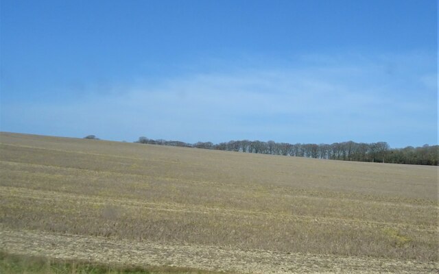
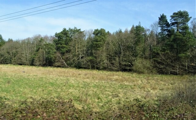
Lower Bigmans Copse is a picturesque woodland located in the county of Wiltshire, England. Situated near the village of Bigmans, this forested area covers approximately 100 acres of land. The copse is nestled within the rolling hills and serene countryside of Wiltshire, providing a tranquil escape for nature enthusiasts and outdoor lovers.

Characterized by its dense foliage and towering trees, Lower Bigmans Copse offers a diverse range of flora and fauna. The woodland is predominantly composed of broadleaf trees such as oak, beech, and ash, which create a rich and vibrant canopy overhead. The forest floor is carpeted with a variety of wildflowers, including bluebells, primroses, and wood anemones, adding splashes of color to the landscape.

Wildlife thrives within Lower Bigmans Copse, with numerous species finding refuge in its lush surroundings. Visitors may spot deer, foxes, badgers, and a wide array of bird species, including woodpeckers, owls, and warblers. The copse also serves as a crucial habitat for several endangered species, such as the lesser spotted woodpecker and the small pearl-bordered fritillary butterfly.

The copse is crisscrossed by a network of walking trails, inviting visitors to explore its natural beauty. These paths wind through the woodland, offering stunning views of ancient trees, babbling brooks, and hidden glades. Nature enthusiasts can revel in the peaceful ambiance, immersing themselves in the sights and sounds of this idyllic woodland.

Lower Bigmans Copse is not only a haven for wildlife and a beloved destination for nature lovers but also a valuable ecological resource in Wiltshire. Its preservation and protection ensure the continued existence of its diverse ecosystem for future generations to enjoy.

If you have any feedback on the listing, please let us know in the comments section below.

Lower Bigmans Copse Images

Images are sourced within 2km of 51.047556/-1.746468 or Grid Reference SU1727. Thanks to Geograph Open Source API. All images are credited.

Hillside stubble field
Common Plantation
Common Plantation
Grazing, Britford
Grazing, Britford
Lower Road
Lower Road
The Old Forge
The Old Forge
Thatched house
Thatched house
Little Manor Farmhouse
Minor road, Britford
Recreation ground under redevelopment New houses being constructed on the site of <a href="https://www.geograph.org.uk/photo/6851674">SU1927 : Recreation ground at Alderbury</a>.
Recreation ground under redevelopment
New houses being constructed on the site of SU1927 : Recreation ground at Alderbury.
View across the green at Alderbury
St Peter, Britford: September 2023
St Peter, Britford: churchyard
St Peter, Britford: font The font in a Christian church is that place where new members are inducted in a ceremony known as a christening. Fonts are often symbolically placed at or near the entrance. Typically, the font is between 90 and 130 centimetres tall and sculpted in stone- although wood and metal are sometimes used.  During the ceremony, a priest traces the sign of the cross on the new member’s forehead.  If an infant, several adults will be asked to be godparents. They will then pledge at the font to guide the child on their Christian journey.
St Peter, Britford: font
The font in a Christian church is that place where new members are inducted in a ceremony known as a christening. Fonts are often symbolically placed at or near the entrance. Typically, the font is between 90 and 130 centimetres tall and sculpted in stone- although wood and metal are sometimes used. During the ceremony, a priest traces the sign of the cross on the new member’s forehead. If an infant, several adults will be asked to be godparents. They will then pledge at the font to guide the child on their Christian journey.
St Peter, Britford: memorial to the 5th Earl For a biography see <span class="nowrap"><a title="https://en.wikipedia.org/wiki/William_Pleydell-Bouverie,_5th_Earl_of_Radnor" rel="nofollow ugc noopener" href="https://en.wikipedia.org/wiki/William_Pleydell-Bouverie,_5th_Earl_of_Radnor">Link</a><img style="margin-left:2px;" alt="External link" title="External link - shift click to open in new window" src="https://s1.geograph.org.uk/img/external.png" width="10" height="10"/></span>
St Peter, Britford: memorial to the 5th Earl
For a biography see LinkExternal link
St Peter, Britford: pulpit A pulpit is a raised stand for preachers in a Christian church. It comes from the Latin 'pulpitum'  meaning platform or staging. It is raised well above the surrounding floor for audibility and visibility, accessed by steps, with sides coming to about waist height. Many have a canopy known as the 'abat-voix', a sounding board to project the preacher's voice to congregation.
St Peter, Britford: pulpit
A pulpit is a raised stand for preachers in a Christian church. It comes from the Latin 'pulpitum' meaning platform or staging. It is raised well above the surrounding floor for audibility and visibility, accessed by steps, with sides coming to about waist height. Many have a canopy known as the 'abat-voix', a sounding board to project the preacher's voice to congregation.
St Peter, Britford: family memorial
St Peter, Britford: memorial to a long serving incumbent
St Peter, Britford: memorial to a 19th century vicar Morres was born in Wokingham on 19 October 1835 and educated at Wadham College, Oxford. After a curacy in Bedminster he served in India for 20 years before coming here.
St Peter, Britford: memorial to a 19th century vicar
Morres was born in Wokingham on 19 October 1835 and educated at Wadham College, Oxford. After a curacy in Bedminster he served in India for 20 years before coming here.
Show me another place!

Lower Bigmans Copse is located at Grid Ref: SU1727 (Lat: 51.047556, Lng: -1.746468)

Unitary Authority: Wiltshire

Police Authority: Wiltshire

What 3 Words

///marinated.cools.correct. Near Alderbury, Wiltshire

Related Wikis

Ivychurch Priory

Ivychurch Priory was a medieval monastic house in Alderbury, southeast of Salisbury, Wiltshire, England. According to Historic England, "all that remains...

Alderbury

Alderbury is a village and civil parish in Wiltshire, England, in the south of the county around 3 miles (5 km) southeast of Salisbury. The parish includes...
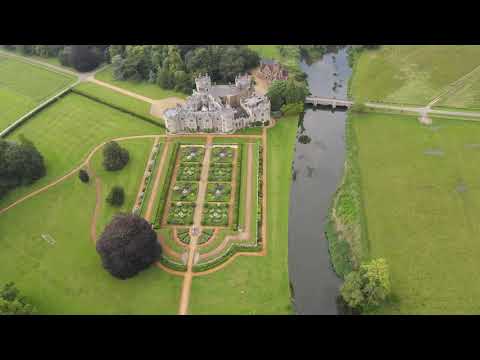
Longford Castle

Longford Castle is a Grade I listed country house on the banks of the River Avon south of Salisbury, Wiltshire, England. It is the seat of the Earl of...

Britford Water Meadows

Britford Water Meadows (grid reference SU166274) is a biological Site of Special Scientific Interest at Britford, south of Salisbury in Wiltshire. It has...

Related Videos

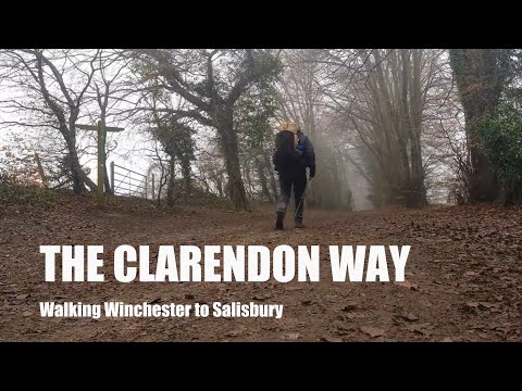
The Clarendon Way | Walking Winchester to Salisbury | Walk the Chalk | Episode 9

The Clarendon Way is a 26 mile / 43 km long distance trail between Winchester, the ancient capital of Saxon England, and ...

~ Don't quit. #shorts

Don't quit. #FitLife #GymMotivation #WorkoutChallenge #FitnessJourney #GymFreak #SweatSession #FitGoals #GymInspiration ...

Nearby Amenities

Located within 500m of 51.047556,-1.746468
Addr Housename: Brownmead Cottage
Source: OS_OpenData_StreetView
Lat/Long: 51.044222/-1.7502916
Turning Circle
Source: Bing
Lat/Long: 51.0443353/-1.7438564
Turning Circle
Lat/Long: 51.0485389/-1.7522792
War Memorial
Historic: memorial
Memorial: war_memorial
Lat/Long: 51.0456879/-1.7402103
The Fountain
Historic: memorial
Lat/Long: 51.0457656/-1.7408299
Turning Circle
Lat/Long: 51.0490221/-1.7405029
The data included in this document is from www.openstreetmap.org. The data is made available under ODbL.

Have you been to Lower Bigmans Copse?

Leave your review of Lower Bigmans Copse below (or comments, questions and feedback).