Boston Hill Wood

Wood, Forest in Yorkshire

England

Boston Hill Wood

The Rochdale Canal at Hebden Bridge
The Rochdale Canal at Hebden Bridge Credit: Dave Pickersgill

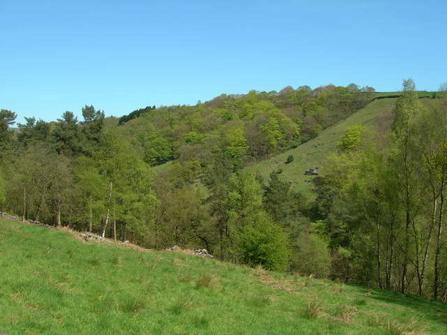
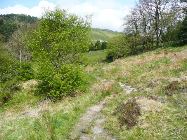
Boston Hill Wood is a picturesque woodland located in the county of Yorkshire, England. Situated near the village of Boston Spa, the wood covers an area of approximately 40 acres and is renowned for its natural beauty and diverse range of flora and fauna.

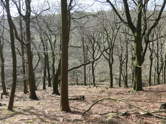
The wood is primarily composed of deciduous trees, including oak, birch, and beech, which create a stunning canopy of greenery during the summer months. In autumn, the woodland transforms into a kaleidoscope of vibrant colors as the leaves change to golden yellows, fiery oranges, and deep reds.

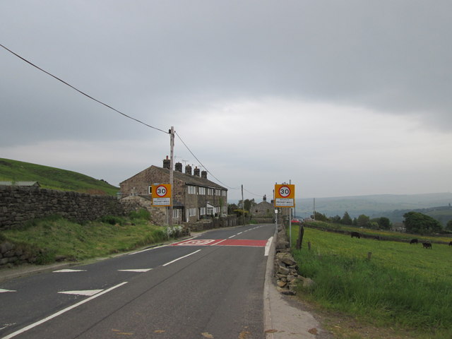
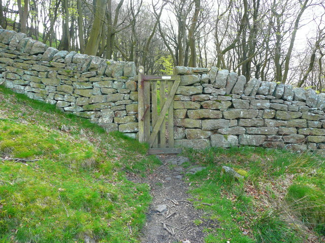
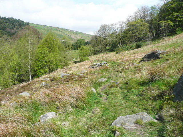
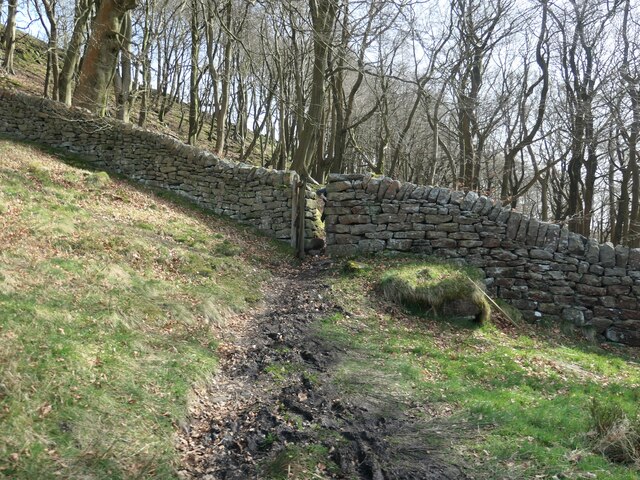
The woodland is crisscrossed by a network of well-maintained footpaths, making it a popular destination for walkers, nature enthusiasts, and families looking to explore the great outdoors. These paths wind their way through the wood, leading visitors to discover hidden clearings, babbling brooks, and a tranquil pond teeming with wildlife.

The diverse range of plant and animal species found within Boston Hill Wood makes it a haven for nature lovers. Squirrels scamper amongst the treetops, while rabbits and hares can be spotted darting through the undergrowth. Birdwatchers will delight in the opportunity to spot woodpeckers, owls, and various species of songbirds.

In addition to its natural beauty, Boston Hill Wood holds historical significance. The woodland is believed to have been part of the ancient Forest of Knaresborough, which once covered a vast area of Yorkshire. Today, it serves as a reminder of the region's rich cultural heritage and offers a peaceful retreat for visitors seeking solace in nature.

If you have any feedback on the listing, please let us know in the comments section below.

Boston Hill Wood Images

Images are sourced within 2km of 53.751248/-2.0097593 or Grid Reference SD9928. Thanks to Geograph Open Source API. All images are credited.

The Rochdale Canal at Hebden Bridge
Aqueduct in Crimsworth Dean The aqueduct connects a dam on the west side of Bridge Clough with one on the east. These dams connect with ones lower down the valley and all appeared to service Midgehole Dye Works
Aqueduct in Crimsworth Dean
The aqueduct connects a dam on the west side of Bridge Clough with one on the east. These dams connect with ones lower down the valley and all appeared to service Midgehole Dye Works
Bridge Clough Looking northeast to Green Hirst Wood.
Bridge Clough
Looking northeast to Green Hirst Wood.
Cottages at New Delight
Weir on Bridge Clough, Wadsworth This is one of several weirs on this stream, and as there seems to be no open channel at that level I think that water must have been abstracted directly into a pipe laid in the river bank.
Weir on Bridge Clough, Wadsworth
This is one of several weirs on this stream, and as there seems to be no open channel at that level I think that water must have been abstracted directly into a pipe laid in the river bank.
Aqueduct bridge over Bridge Clough, Wadsworth According to information attached to a photograph that I have seen on the internet, this bridge carries flow from a millpond on the other side of the stream. There is also a well-used path across it.
Aqueduct bridge over Bridge Clough, Wadsworth
According to information attached to a photograph that I have seen on the internet, this bridge carries flow from a millpond on the other side of the stream. There is also a well-used path across it.
Millpond above Bridge Clough, Wadsworth There is a string of millponds along the eastern hillside of Crimsworth Dean, above the stream where it is called Bridge Clough. These intercept streams coming down through Purprise Wood and Middle Dean Wood. They were built in 1860-1 to increase the supply of water to Midgehole Dyeworks (captioned Crimsworth Dyeworks on the 1:2500 map of c.1893). The works had been converted from Upper Midgehole Mill (cotton) during the 'Cotton Panic', a depression in the textile industry caused by overproduction and by import restrictions due to the American Civil War. (Information from 'From Fulling to Fustionopolis' website) The dyeworks survived until 2009. The uppermost millpond (they are also called water lodges) was on the other side of the stream, with outflow crossing the stream on an aqueduct bridge (not the one thus captioned on the current 'Explorer' map). There are also some weirs on the stream, but I don't know whether they also supplied water to the dyeworks, or perhaps to the Lower Midgehole cotton mill. A voluntary organisation called 'Slow the Flow, Calderdale', who are investigating ways to reduce the risk of flooding in the Calder Valley, considered recommending that the ponds be restored to store rainfall runoff, but I think that they probably found that the work would cost too much.
Millpond above Bridge Clough, Wadsworth
There is a string of millponds along the eastern hillside of Crimsworth Dean, above the stream where it is called Bridge Clough. These intercept streams coming down through Purprise Wood and Middle Dean Wood. They were built in 1860-1 to increase the supply of water to Midgehole Dyeworks (captioned Crimsworth Dyeworks on the 1:2500 map of c.1893). The works had been converted from Upper Midgehole Mill (cotton) during the 'Cotton Panic', a depression in the textile industry caused by overproduction and by import restrictions due to the American Civil War. (Information from 'From Fulling to Fustionopolis' website) The dyeworks survived until 2009. The uppermost millpond (they are also called water lodges) was on the other side of the stream, with outflow crossing the stream on an aqueduct bridge (not the one thus captioned on the current 'Explorer' map). There are also some weirs on the stream, but I don't know whether they also supplied water to the dyeworks, or perhaps to the Lower Midgehole cotton mill. A voluntary organisation called 'Slow the Flow, Calderdale', who are investigating ways to reduce the risk of flooding in the Calder Valley, considered recommending that the ponds be restored to store rainfall runoff, but I think that they probably found that the work would cost too much.
Wadsworth Footpath 35 in Purprise Wood Here the path crosses one of the many little streams that flow down the hillside.
Wadsworth Footpath 35 in Purprise Wood
Here the path crosses one of the many little streams that flow down the hillside.
Gate on Wadsworth FP34 leaving Purprise Wood This image looks rather weird at 'thumbnail' size due to the deep shadows of trees (I did not have a saw with me), but makes sense when magnified. The gate is very narrow, covering a 'squeeze' stile.
Gate on Wadsworth FP34 leaving Purprise Wood
This image looks rather weird at 'thumbnail' size due to the deep shadows of trees (I did not have a saw with me), but makes sense when magnified. The gate is very narrow, covering a 'squeeze' stile.
Wadsworth FP23 The path turns right here. This wood is a National Trust property.
Wadsworth FP23
The path turns right here. This wood is a National Trust property.
The uppermost reservoir in Middle Dean, Wadsworth The path continues along the dam on the right-hand side, and carries on probably to the weir. You can also take a path up to Wadsworth FP23, which will take you to the footbridge. There is a seat here if you want to sit quietly for a while. A heron flew across just before I switched the camera on to take this photograph.
The uppermost reservoir in Middle Dean, Wadsworth
The path continues along the dam on the right-hand side, and carries on probably to the weir. You can also take a path up to Wadsworth FP23, which will take you to the footbridge. There is a seat here if you want to sit quietly for a while. A heron flew across just before I switched the camera on to take this photograph.
Path to the weir, Crimsworth Dean, Wadsworth This path goes along the line of a water conduit to the weir that feeds the upper millpond. It does not continue to Wheat Ing Bridge.
Path to the weir, Crimsworth Dean, Wadsworth
This path goes along the line of a water conduit to the weir that feeds the upper millpond. It does not continue to Wheat Ing Bridge.
Gate on Wadsworth FP34 entering Purprise Wood This is the gate shown, not very clearly, from the other side in <a href="https://www.geograph.org.uk/photo/5323250">SD9830 : Gate on Wadsworth FP34 leaving Purprise Wood</a>.
Gate on Wadsworth FP34 entering Purprise Wood
This is the gate shown, not very clearly, from the other side in SD9830 : Gate on Wadsworth FP34 leaving Purprise Wood.
Wadsworth FP34 in what was Brotherton Wood
Wadsworth FP34 in what was Brotherton Wood In places there is rough stone paving.
Wadsworth FP34 in what was Brotherton Wood
In places there is rough stone paving.
"Follow the clear path ... into Purprise Wood" Quoted from 'Route 23: High Brown Knoll, White Hill & Crimsworth Dean from Hebden Bridge' in Christopher Goddard's guidebook, 'The West Yorkshire Moors'.
"Follow the clear path ... into Purprise Wood"
Quoted from 'Route 23: High Brown Knoll, White Hill & Crimsworth Dean from Hebden Bridge' in Christopher Goddard's guidebook, 'The West Yorkshire Moors'.
Purprise Wood, east bank of Bridge Clough This wood is on the earliest large scale OS map, surveyed in the late 1840s.
Purprise Wood, east bank of Bridge Clough
This wood is on the earliest large scale OS map, surveyed in the late 1840s.
"Follow the splodges of yellow paint on the trees" Waymarked public footpath in Purprise Wood. Quoted from 'Route 23: High Brown Knoll, White Hill & Crimsworth Dean from Hebden Bridge' in Christopher Goddard's guidebook, 'The West Yorkshire Moors'.
"Follow the splodges of yellow paint on the trees"
Waymarked public footpath in Purprise Wood. Quoted from 'Route 23: High Brown Knoll, White Hill & Crimsworth Dean from Hebden Bridge' in Christopher Goddard's guidebook, 'The West Yorkshire Moors'.
Show me another place!

Boston Hill Wood is located at Grid Ref: SD9928 (Lat: 53.751248, Lng: -2.0097593)

Division: West Riding

Unitary Authority: Calderdale

Police Authority: West Yorkshire

What 3 Words

///conforms.forum.dent. Near Hebden Bridge, West Yorkshire

Related Wikis

Old Town, West Yorkshire

Old Town is a village in Calderdale, West Yorkshire, England. It is situated on a hilltop above Hebden Bridge and across the Hebden valley from Heptonstall...

Wainsgate Baptist Church

Wainsgate Baptist Church is a redundant chapel standing in an elevated position above the town of Hebden Bridge, West Yorkshire, England (grid reference...

Wadsworth, West Yorkshire

Wadsworth is a civil parish in the Metropolitan Borough of Calderdale in West Yorkshire, England. It has a population of 1,456, increasing to 1,603 at...

Hepton Rural District

Hepton was a rural district in the West Riding of Yorkshire, England, from 1894 to 1974. The district included four civil parishes: Heptonstall, Blackshaw...

Birchcliffe Baptist Church

Birchcliffe Baptist Church is a redundant Baptist chapel in the town of Hebden Bridge, West Yorkshire, England. It was founded by Daniel Taylor in 1764...

Hebden Bridge Town Hall

Hebden Bridge Town Hall, formerly Hebden Bridge Council Offices, is a municipal building in St George's Street, Hebden Bridge, West Yorkshire, England...

Hebden Royd

Hebden Royd is a civil parish in the Metropolitan Borough of Calderdale in West Yorkshire, England. According to the 2001 census it had a population of...

Hebden Bridge

Hebden Bridge is a market town in the Calderdale district of West Yorkshire, England. It is in the Upper Calder Valley, 8 miles (13 km) west of Halifax...

Related Videos

Hebden Bridge Walk Through #shorts #short

A quite walk through Hebden Bridge Last year #shorts #short #hebdenbridge #yorkshire #travel.

Hebden Bridge England UK Winter Walking Tour 4K Relaxing No Talking West Yorkshire Vintage Town

Hebden Bridge England UK Winter Walking Tour 4K Relaxing No Talking West Yorkshire Vintage Town.

Hebden Bridge Yorkshire | voted the greatest town in Europe

Welcome to the delightful town of Hebden Bridge, a hidden gem nestled in the breathtaking beauty of West Yorkshire, England!

Hebden Bridge In England - 5K HDR Walking Tour of the 4th Funkiest Town in the World

Open to Collab with Travel Companies, please send an email. Support my work; https://www.buymeacoffee.com/wasimahmed ...

Nearby Amenities

Located within 500m of 53.751248,-2.0097593
Fixme: Confirm exact location
Image: https://www.geograph.org.uk/photo/6794286
Waterway: weir
Lat/Long: 53.7514333/-2.0130777
Bus Stop
Keighley Road Lee Mill Road
Bus: yes
Local Ref: 45018997
Naptan AtcoCode: 450018997
Naptan Bearing: NW
Naptan CommonName: Keighley Road Lee Mill Road
Naptan Crossing: Lee Mill Road
Naptan Indicator: Stop 45018997
Naptan Notes: OSR taken place 061005
Naptan PlusbusZoneRef: LEEDS
Naptan ShortCommonName: Lee Mill Road
Naptan Street: Keighley Road
Naptan Verified: no
Public Transport: platform
Source: naptan_import
Lat/Long: 53.7472498/-2.0109787
Bus Stop
Keighley Road
Local Ref: 45018998
Naptan AtcoCode: 450018998
Naptan Bearing: NW
Naptan CommonName: Keighley Road
Naptan Crossing: Midgehole Road
Naptan Indicator: Stop 45018998
Naptan PlusbusZoneRef: LEEDS
Naptan ShortCommonName: Midgehole Road
Naptan Street: Keighley Road
Naptan Verified: no
Source: naptan_import
Lat/Long: 53.7480676/-2.0117219
Bus Stop
Midgehole Road
Local Ref: 45018999
Naptan AtcoCode: 450018999
Naptan Bearing: S
Naptan CommonName: Midgehole Road
Naptan Crossing: Nr-At Keighley Road
Naptan Indicator: Stop 45018999
Naptan PlusbusZoneRef: LEEDS
Naptan ShortCommonName: Hebden Grove
Naptan Street: Midgehole Road
Naptan Verified: no
Source: naptan_import
Lat/Long: 53.7502068/-2.012314
Bus Stop
Akroyd Lane
Local Ref: 45020909
Naptan AtcoCode: 450020909
Naptan Bearing: N
Naptan CommonName: Akroyd Lane
Naptan Crossing: Wainsgate
Naptan Indicator: Stop 45020909
Naptan PlusbusZoneRef: LEEDS
Naptan ShortCommonName: Wainsgate
Naptan Street: Akroyd Lane
Naptan Verified: no
Source: naptan_import
Lat/Long: 53.7552497/-2.0064156
Bus Stop
Parrock Lane Old Town Mill Lane
Local Ref: 45020910
Naptan AtcoCode: 450020910
Naptan Bearing: NW
Naptan CommonName: Parrock Lane Old Town Mill Lane
Naptan Crossing: Old Town Mill Lane
Naptan Indicator: Stop 45020910
Naptan Notes: Awaiting new photo - shelter lit by Solar Panel
Naptan PlusbusZoneRef: LEEDS
Naptan ShortCommonName: Old Town Mill Lane
Naptan Street: Parrock Lane
Naptan Verified: no
Source: naptan_import
Lat/Long: 53.7537757/-2.0041556
Bus Stop
Keighley Road
Local Ref: 45024091
Naptan AtcoCode: 450024091
Naptan Bearing: N
Naptan CommonName: Keighley Road
Naptan Crossing: Nr-At Midgehole Road (0.2km towards Pecket Well)
Naptan Indicator: Stop 45024091
Naptan Notes: OSR taken place 051005
Naptan PlusbusZoneRef: LEEDS
Naptan ShortCommonName: Midgehole Road
Naptan Street: Keighley Road
Naptan Verified: no
Source: naptan_import
Lat/Long: 53.7502069/-2.0115557
Bus Stop
Midgehole Road
Bench: no
Bin: no
Local Ref: 45024293
Naptan AtcoCode: 450024293
Naptan Bearing: S
Naptan CommonName: Midgehole Road
Naptan Crossing: Nr-At Midgehole Lane
Naptan Indicator: Stop 45024293
Naptan Landmark: Adj Rawholme Farm & Springwood
Naptan PlusbusZoneRef: LEEDS
Naptan ShortCommonName: Spring Wood
Naptan Street: Midgehole Road
Naptan Verified: no
Shelter: no
Source: naptan_import
Tactile Paving: no
Lat/Long: 53.7542517/-2.0105255
Keighley Road Lee Mill Lane
Local Ref: 45025581
Naptan AtcoCode: 450025581
Naptan Bearing: SE
Naptan BusStopType: CUS
Naptan CommonName: Keighley Road Lee Mill Lane
Naptan Crossing: Lee Mill Lane
Naptan Indicator: Stop 45025581
Naptan PlusbusZoneRef: LEEDS
Naptan ShortCommonName: Lee Mill Lane
Naptan Street: Keighley Road
Naptan Verified: no
Source: naptan_import
Lat/Long: 53.7472947/-2.0108574
Bus Stop
Keighley Road
Local Ref: 45025676
Naptan AtcoCode: 450025676
Naptan Bearing: SE
Naptan CommonName: Keighley Road
Naptan Crossing: Hurst Road
Naptan Indicator: Stop 45025676
Naptan PlusbusZoneRef: LEEDS
Naptan ShortCommonName: Hurst Road
Naptan Street: Keighley Road
Naptan Verified: no
Source: naptan_import
Lat/Long: 53.7481306/-2.0116158
Midgehole Road
Local Ref: 45025678
Naptan AtcoCode: 450025678
Naptan Bearing: N
Naptan BusStopType: CUS
Naptan CommonName: Midgehole Road
Naptan Crossing: Twixt Keighley Road & Midgehole Lane
Naptan Indicator: Stop 45025678
Naptan PlusbusZoneRef: LEEDS
Naptan ShortCommonName: Spring Wood
Naptan Street: Midgehole Road
Naptan Verified: no
Source: naptan_import
Lat/Long: 53.7542427/-2.0106772
Keighley Road
Local Ref: 45024668
Naptan AtcoCode: 450024668
Naptan Bearing: S
Naptan BusStopType: CUS
Naptan CommonName: Keighley Road
Naptan Crossing: Twixt Akroyd Lane & Midgehole Road
Naptan Indicator: Stop 45024668
Naptan PlusbusZoneRef: LEEDS
Naptan ShortCommonName: Spring Wood
Naptan Street: Keighley Road
Naptan Verified: no
Source: naptan_import
Lat/Long: 53.7529845/-2.0086749
Bus Stop
Parrock Lane
Local Ref: 45025287
Naptan AtcoCode: 450025287
Naptan Bearing: SE
Naptan BusStopType: CUS
Naptan CommonName: Parrock Lane
Naptan Crossing: Wainsgate Lane
Naptan Indicator: Stop 45025287
Naptan PlusbusZoneRef: LEEDS
Naptan ShortCommonName: Akroyd Lane
Naptan Street: Parrock Lane
Naptan Verified: no
Source: naptan_import
Lat/Long: 53.7539644/-2.0043224
Midgehole Road
Local Ref: 45050729
Naptan AtcoCode: 450050729
Naptan Bearing: N
Naptan BusStopType: CUS
Naptan CommonName: Midgehole Road
Naptan Indicator: Stop 45050729
Naptan PlusbusZoneRef: LEEDS
Naptan ShortCommonName: Hebden Grove
Naptan Street: Midgehole Road
Naptan Verified: no
Source: naptan_import
Lat/Long: 53.7502068/-2.0123898
Keighley Road
Local Ref: 45051386
Naptan AtcoCode: 450051386
Naptan Bearing: S
Naptan BusStopType: CUS
Naptan CommonName: Keighley Road
Naptan Indicator: Stop 45051386
Naptan PlusbusZoneRef: LEEDS
Naptan ShortCommonName: Boston Hill Wood
Naptan Street: Keighley Road
Naptan Verified: no
Source: naptan_import
Lat/Long: 53.7501889/-2.0114344
Old Town
Place: village
Wikidata: Q7085254
Lat/Long: 53.7516222/-2.0043107
Grit Bin
Lat/Long: 53.7517077/-2.0125215
Barrier: stile
Lat/Long: 53.7472142/-2.006388
Post Box
Brand: Royal Mail
Brand Wikidata: Q638098
Brand Wikipedia: en:Royal Mail
Collection Times: Mo-Fr 09:00; Sa 07:00; Su off
Operator: Royal Mail
Operator Wikidata: Q638098
Post Box Type: wall
Ref: HX7 186D
Royal Cypher: EIIR
Royal Cypher Wikidata: Q33102113
Lat/Long: 53.7538645/-2.0044611
Power: pole
Lat/Long: 53.7522135/-2.01452
Power: pole
Lat/Long: 53.7540579/-2.0145831
Power: pole
Transformer: distribution
Lat/Long: 53.7534235/-2.0143926
Power: pole
Lat/Long: 53.7527852/-2.0138723
Covered: no
Leisure: picnic_table
Lat/Long: 53.7474832/-2.0138535
Lower Lee Farm
Place: farm
Source Name: OS_OpenData_StreetView
Lat/Long: 53.7529787/-2.0150659
Lower Lee
Place: hamlet
Source Name: OS_OpenData_StreetView
Lat/Long: 53.7537193/-2.0152509
Barrier: entrance
Lat/Long: 53.7542158/-2.0104597
Power: pole
Lat/Long: 53.7521659/-2.0133667
The data included in this document is from www.openstreetmap.org. The data is made available under ODbL.

Have you been to Boston Hill Wood?

Leave your review of Boston Hill Wood below (or comments, questions and feedback).