Spring Wood

Wood, Forest in Yorkshire

England

Spring Wood

The Rochdale Canal at Hebden Bridge
The Rochdale Canal at Hebden Bridge Credit: Dave Pickersgill

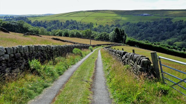
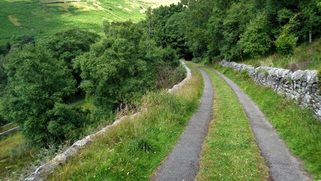
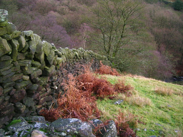
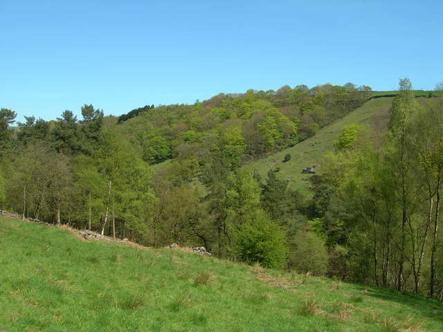
Spring Wood is a picturesque woodland located in the county of Yorkshire, England. Situated in the heart of the countryside, it covers an area of approximately 50 hectares and is renowned for its natural beauty and diverse wildlife.

The woodland is primarily composed of native broadleaf trees such as oak, beech, and birch, which create a dense canopy providing shelter and habitat for a variety of species. The forest floor is carpeted with an array of wildflowers, including bluebells, primroses, and wood anemones, which add a vibrant and colorful touch to the landscape during springtime.

Tranquil streams meander through the wood, creating a serene atmosphere and providing a water source for the abundant wildlife that calls Spring Wood home. Roe deer, foxes, badgers, and a myriad of bird species are frequently spotted within the woodland, making it a popular destination for nature enthusiasts and birdwatchers.

The wood is crisscrossed with well-maintained footpaths and bridleways, allowing visitors to explore its natural wonders. There are also designated picnic areas and benches scattered throughout the woodland, providing opportunities for visitors to relax and enjoy the peaceful surroundings.

Spring Wood is managed by the local council, which ensures its conservation and protection. Educational programs and guided walks are regularly organized to raise awareness about the importance of preserving this unique natural habitat.

Overall, Spring Wood offers a tranquil retreat for those seeking solace in nature. With its stunning scenery, diverse wildlife, and peaceful ambiance, it is a true gem within the Yorkshire countryside.

If you have any feedback on the listing, please let us know in the comments section below.

Spring Wood Images

Images are sourced within 2km of 53.756497/-2.0108071 or Grid Reference SD9928. Thanks to Geograph Open Source API. All images are credited.

The Rochdale Canal at Hebden Bridge
Abel Cross A pair of wayside marker stones on the slopes above Crimsworth Dean
Abel Cross
A pair of wayside marker stones on the slopes above Crimsworth Dean
Helliwell Wood Farmhouse In Crimsworth Dean
Helliwell Wood Farmhouse
In Crimsworth Dean
Aqueduct in Crimsworth Dean The aqueduct connects a dam on the west side of Bridge Clough with one on the east. These dams connect with ones lower down the valley and all appeared to service Midgehole Dye Works
Aqueduct in Crimsworth Dean
The aqueduct connects a dam on the west side of Bridge Clough with one on the east. These dams connect with ones lower down the valley and all appeared to service Midgehole Dye Works
Small Shaw Lane Descending into Crimsworth Dean and approaching the first of two hairpin bends to reach the valley bottom
Small Shaw Lane
Descending into Crimsworth Dean and approaching the first of two hairpin bends to reach the valley bottom
Small Shaw Lane Descending into Crimsworth Dean and approaching the second of two hairpin bends to reach the valley bottom
Small Shaw Lane
Descending into Crimsworth Dean and approaching the second of two hairpin bends to reach the valley bottom
Drystone wall in Crimsworth Dean
Bridge Clough Looking northeast to Green Hirst Wood.
Bridge Clough
Looking northeast to Green Hirst Wood.
Ordnance Survey Cut Mark with Pivot This can be found on Abel Cross.
For more detail see : <span class="nowrap"><a title="http://www.bench-marks.org.uk/bm45922" rel="nofollow ugc noopener" href="http://www.bench-marks.org.uk/bm45922">Link</a><img style="margin-left:2px;" alt="External link" title="External link - shift click to open in new window" src="https://s1.geograph.org.uk/img/external.png" width="10" height="10"/></span>
Ordnance Survey Cut Mark with Pivot
This can be found on Abel Cross. For more detail see : LinkExternal link
Abel Cross
Abel Cross
Abel Cross
Abel Cross
Benchmark at Abel Cote Farm
Track to Abel Cote Farm
Boundary of enclosed fields above Abel Cote, Crimsworth Dean To the left the land rises up to Turn Hill and Black Hill.
Boundary of enclosed fields above Abel Cote, Crimsworth Dean
To the left the land rises up to Turn Hill and Black Hill.
Rough grazing north west of Abel Cote, Crimsworth Dean
Abel Cross A pair of stone wayside crosses on the hillside above Crimsworth Dean. According to folklore, these are , which are said to mark the graves of two swains who killed each other for the love of a lady, with the waterfall at nearby Lumb Bridge, where the woman is said to have committed suicide by jumping into the falls from the bridge. There are stories of a White Lady who haunts the bridge by night.

The Register of Ancient Monuments includes the following description:

"The monument is a sandstone wayside cross located near the edge of Shackleton Moor. It comprises the separated halves of a massive tapering socle or cross base, each housing a rectangular section shaft. The bevelled tops of the shafts indicate that there have never been cross-heads. This suggests that the cross is probably of post-medieval date. Currently, the halves of the socle are set c2m apart, slightly NW and SE of each other, with the vertical cut faces of each orientated SE. This indicates that one half must have been turned round and moved apart. As the SE example is less deeply embedded in the ground that the NW example, it is likely to have been the former.

The SE half of the socle has a maximum visible height of 87cm compared to the 69cm of the NW half. Its outer width along the top edge is 57cm while the same dimension on the NW example is 60cm. The inner width of both halves is 64cm which indicates that the socle was not of uniformly rectangular section but bowed out in the middle. The combined length of the socle would have been 152cm with the SE half measuring 69cm and the NW half 83cm. Both shafts are mortared into rectangular socket holes set 21cm from the outer edge of the socle and apparently also c21cm apart. The SE shaft is 99cm tall and has a base measurement of 34cm by 21cm while the NW shaft measures 114cm by 54cm by 28cm. The latter tapers towards the top to 30cm by 24cm and the former to 22cm by 16cm. The socle, though finely dressed and covered with toolmarks, is undecorated except for a surveyor's bench mark inscribed near the southern corner of the SE half. Both leading faces of each shaft are inscribed with a Latin cross of two incised lines whose simplicity also suggests a post-medieval date. The cross is orientated SW-NE so that the incised crosses can be seen from either direction on the adjacent track. This suggests that the cross marked an ancient route across the moor, though it may also have served as a boundary marker. "
<span class="nowrap"><a title="http://www.calderdale.gov.uk/environment/conservation/ancient-monuments/monuments-full.jsp?propno=HSK499DWL2000" rel="nofollow ugc noopener" href="http://www.calderdale.gov.uk/environment/conservation/ancient-monuments/monuments-full.jsp?propno=HSK499DWL2000">Link</a><img style="margin-left:2px;" alt="External link" title="External link - shift click to open in new window" src="https://s1.geograph.org.uk/img/external.png" width="10" height="10"/></span>
Abel Cross
A pair of stone wayside crosses on the hillside above Crimsworth Dean. According to folklore, these are , which are said to mark the graves of two swains who killed each other for the love of a lady, with the waterfall at nearby Lumb Bridge, where the woman is said to have committed suicide by jumping into the falls from the bridge. There are stories of a White Lady who haunts the bridge by night. The Register of Ancient Monuments includes the following description: "The monument is a sandstone wayside cross located near the edge of Shackleton Moor. It comprises the separated halves of a massive tapering socle or cross base, each housing a rectangular section shaft. The bevelled tops of the shafts indicate that there have never been cross-heads. This suggests that the cross is probably of post-medieval date. Currently, the halves of the socle are set c2m apart, slightly NW and SE of each other, with the vertical cut faces of each orientated SE. This indicates that one half must have been turned round and moved apart. As the SE example is less deeply embedded in the ground that the NW example, it is likely to have been the former. The SE half of the socle has a maximum visible height of 87cm compared to the 69cm of the NW half. Its outer width along the top edge is 57cm while the same dimension on the NW example is 60cm. The inner width of both halves is 64cm which indicates that the socle was not of uniformly rectangular section but bowed out in the middle. The combined length of the socle would have been 152cm with the SE half measuring 69cm and the NW half 83cm. Both shafts are mortared into rectangular socket holes set 21cm from the outer edge of the socle and apparently also c21cm apart. The SE shaft is 99cm tall and has a base measurement of 34cm by 21cm while the NW shaft measures 114cm by 54cm by 28cm. The latter tapers towards the top to 30cm by 24cm and the former to 22cm by 16cm. The socle, though finely dressed and covered with toolmarks, is undecorated except for a surveyor's bench mark inscribed near the southern corner of the SE half. Both leading faces of each shaft are inscribed with a Latin cross of two incised lines whose simplicity also suggests a post-medieval date. The cross is orientated SW-NE so that the incised crosses can be seen from either direction on the adjacent track. This suggests that the cross marked an ancient route across the moor, though it may also have served as a boundary marker. " LinkExternal link
Roadworks at the junction of Haworth Old Road with the A6033 Above Pecket Well, on the road between Hebden Bridge and Oxenhope. One lane of the main road was closed while a wall was being rebuilt.

As the guide stone indicates and the name plate suggests, the old pre-turnpike route towards Haworth heads off to the left  here, running up Crimsworth Dean. Beyond Lane Head this becomes a rough track as it approaches the watershed and the Calderdale / Kirklees boundary.
Roadworks at the junction of Haworth Old Road with the A6033
Above Pecket Well, on the road between Hebden Bridge and Oxenhope. One lane of the main road was closed while a wall was being rebuilt. As the guide stone indicates and the name plate suggests, the old pre-turnpike route towards Haworth heads off to the left here, running up Crimsworth Dean. Beyond Lane Head this becomes a rough track as it approaches the watershed and the Calderdale / Kirklees boundary.
Show me another place!

Spring Wood is located at Grid Ref: SD9928 (Lat: 53.756497, Lng: -2.0108071)

Division: West Riding

Unitary Authority: Calderdale

Police Authority: West Yorkshire

What 3 Words

///collides.outsize.covenants. Near Hebden Bridge, West Yorkshire

Related Wikis

Wainsgate Baptist Church

Wainsgate Baptist Church is a redundant chapel standing in an elevated position above the town of Hebden Bridge, West Yorkshire, England (grid reference...

Old Town, West Yorkshire

Old Town is a village in Calderdale, West Yorkshire, England. It is situated on a hilltop above Hebden Bridge and across the Hebden valley from Heptonstall...

Wadsworth, West Yorkshire

Wadsworth is a civil parish in the Metropolitan Borough of Calderdale in West Yorkshire, England. It has a population of 1,456, increasing to 1,603 at...

Hepton Rural District

Hepton was a rural district in the West Riding of Yorkshire, England, from 1894 to 1974. The district included four civil parishes: Heptonstall, Blackshaw...

Chiserley

Chiserley is a hamlet located on a hilltop near the town of Hebden Bridge, in the county of West Yorkshire, England. The Hamlet falls within the Calder...

Birchcliffe Baptist Church

Birchcliffe Baptist Church is a redundant Baptist chapel in the town of Hebden Bridge, West Yorkshire, England. It was founded by Daniel Taylor in 1764...

Hebden Bridge Town Hall

Hebden Bridge Town Hall, formerly Hebden Bridge Council Offices, is a municipal building in St George's Street, Hebden Bridge, West Yorkshire, England...

Hebden Royd

Hebden Royd is a civil parish in the Metropolitan Borough of Calderdale in West Yorkshire, England. According to the 2001 census it had a population of...

Nearby Amenities

Located within 500m of 53.756497,-2.0108071
Waterway: weir
Lat/Long: 53.7575363/-2.0181443
Generator Output Electricity: yes
Generator Source: wind
Power: generator
Lat/Long: 53.7573218/-2.0071635
Bus Stop
Keighley Road
Local Ref: 45020901
Naptan AtcoCode: 450020901
Naptan Bearing: SE
Naptan CommonName: Keighley Road
Naptan Crossing: Nr-At Akroyd Lane (Approx 0.5km Hebden Bridge si
Naptan Indicator: Stop 45020901
Naptan PlusbusZoneRef: LEEDS
Naptan ShortCommonName: Galstones Wood
Naptan Street: Keighley Road
Naptan Verified: no
Source: naptan_import
Lat/Long: 53.7567955/-2.0091307
Bus Stop
Keighley Road Pecket Well
Local Ref: 45020902
Naptan AtcoCode: 450020902
Naptan Bearing: SW
Naptan CommonName: Keighley Road Pecket Well
Naptan Indicator: Stop 45020902
Naptan Landmark: Kitling Bridge
Naptan Notes: OSR taken place 140905
Naptan PlusbusZoneRef: LEEDS
Naptan ShortCommonName: Akroyd
Naptan Street: Keighley Road
Naptan Verified: no
Source: naptan_import
Lat/Long: 53.7590515/-2.0089644
Bus Stop
Akroyd Lane Shaw Croft Hill
Bus: yes
Departures Board: timetable
Local Ref: 45020908
Naptan AtcoCode: 450020908
Naptan Bearing: N
Naptan CommonName: Akroyd Lane Shaw Croft Hill
Naptan Crossing: Shaw Croft Hill
Naptan Indicator: Stop 45020908
Naptan Landmark: Akroyd Farm
Naptan Notes: TF installed size 3p ttc a/w survey
Naptan PlusbusZoneRef: LEEDS
Naptan ShortCommonName: Akroyd Farm
Naptan Street: Akroyd Lane
Naptan Verified: no
Public Transport: platform
Shelter: yes
Source: naptan_import
Lat/Long: 53.7578194/-2.0071809
Bus Stop
Akroyd Lane
Local Ref: 45020909
Naptan AtcoCode: 450020909
Naptan Bearing: N
Naptan CommonName: Akroyd Lane
Naptan Crossing: Wainsgate
Naptan Indicator: Stop 45020909
Naptan PlusbusZoneRef: LEEDS
Naptan ShortCommonName: Wainsgate
Naptan Street: Akroyd Lane
Naptan Verified: no
Source: naptan_import
Lat/Long: 53.7552497/-2.0064156
Bus Stop
Midgehole Road
Bench: no
Bin: no
Local Ref: 45024293
Naptan AtcoCode: 450024293
Naptan Bearing: S
Naptan CommonName: Midgehole Road
Naptan Crossing: Nr-At Midgehole Lane
Naptan Indicator: Stop 45024293
Naptan Landmark: Adj Rawholme Farm & Springwood
Naptan PlusbusZoneRef: LEEDS
Naptan ShortCommonName: Spring Wood
Naptan Street: Midgehole Road
Naptan Verified: no
Shelter: no
Source: naptan_import
Tactile Paving: no
Lat/Long: 53.7542517/-2.0105255
Midgehole Road
Local Ref: 45025678
Naptan AtcoCode: 450025678
Naptan Bearing: N
Naptan BusStopType: CUS
Naptan CommonName: Midgehole Road
Naptan Crossing: Twixt Keighley Road & Midgehole Lane
Naptan Indicator: Stop 45025678
Naptan PlusbusZoneRef: LEEDS
Naptan ShortCommonName: Spring Wood
Naptan Street: Midgehole Road
Naptan Verified: no
Source: naptan_import
Lat/Long: 53.7542427/-2.0106772
Keighley Road
Local Ref: 45024668
Naptan AtcoCode: 450024668
Naptan Bearing: S
Naptan BusStopType: CUS
Naptan CommonName: Keighley Road
Naptan Crossing: Twixt Akroyd Lane & Midgehole Road
Naptan Indicator: Stop 45024668
Naptan PlusbusZoneRef: LEEDS
Naptan ShortCommonName: Spring Wood
Naptan Street: Keighley Road
Naptan Verified: no
Source: naptan_import
Lat/Long: 53.7529845/-2.0086749
Bus Stop
Midgehole Road Hebden Terrace
Local Ref: 45024709
Naptan AtcoCode: 450024709
Naptan Bearing: SE
Naptan CommonName: Midgehole Road Hebden Terrace
Naptan Crossing: Hebden Terrace
Naptan Indicator: Stop 45024709
Naptan PlusbusZoneRef: LEEDS
Naptan ShortCommonName: Hebden Terrace
Naptan Street: Midgehole Road
Naptan Verified: no
Source: naptan_import
Lat/Long: 53.7572081/-2.0148274
Bus Stop
Akroyd Lane
Local Ref: 45025763
Naptan AtcoCode: 450025763
Naptan Bearing: S
Naptan CommonName: Akroyd Lane
Naptan Crossing: Wainsgate
Naptan Indicator: Stop 45025763
Naptan PlusbusZoneRef: LEEDS
Naptan ShortCommonName: Wainsgate
Naptan Street: Akroyd Lane
Naptan Verified: no
Source: naptan_import
Lat/Long: 53.7553755/-2.0063549
Keighley Road
Local Ref: 45051042
Naptan AtcoCode: 450051042
Naptan Bearing: NW
Naptan BusStopType: CUS
Naptan CommonName: Keighley Road
Naptan Indicator: Stop 45051042
Naptan PlusbusZoneRef: LEEDS
Naptan ShortCommonName: Midgehole
Naptan Street: Keighley Road
Naptan Verified: no
Source: naptan_import
Lat/Long: 53.7567685/-2.0092217
Bus Stop
Keighley Road Ackroyd Path
Local Ref: 45051043
Naptan AtcoCode: 450051043
Naptan Bearing: NE
Naptan BusStopType: CUS
Naptan CommonName: Keighley Road Ackroyd Path
Naptan Crossing: Ackroyd Path
Naptan Indicator: Stop 45051043
Naptan PlusbusZoneRef: LEEDS
Naptan ShortCommonName: Sunny Royd
Naptan Street: Keighley Road
Naptan Verified: no
Source: naptan_import
Lat/Long: 53.7591055/-2.0090554
Bus Stop
Akroyd Lane Shaw Croft Hill
Bus: yes
Local Ref: 45051049
Naptan AtcoCode: 450051049
Naptan Bearing: S
Naptan BusStopType: CUS
Naptan CommonName: Akroyd Lane Shaw Croft Hill
Naptan Indicator: Stop 45051049
Naptan PlusbusZoneRef: LEEDS
Naptan ShortCommonName: Akroyd Farm
Naptan Street: Akroyd Lane
Naptan Verified: no
Public Transport: platform
Source: naptan_import
Lat/Long: 53.7577484/-2.0070378
Midgehole Road Dye Works
Local Ref: 45051467
Naptan AtcoCode: 450051467
Naptan Bearing: NW
Naptan BusStopType: CUS
Naptan CommonName: Midgehole Road Dye Works
Naptan Indicator: Stop 45051467
Naptan PlusbusZoneRef: LEEDS
Naptan ShortCommonName: Hebden Terrace
Naptan Street: Midgehole Road
Naptan Verified: no
Source: naptan_import
Lat/Long: 53.7571534/-2.0148652
Smeekin Hill War Memorial.
Historic: memorial
Wheelchair: no
Lat/Long: 53.7597419/-2.0135356
Barrier: stile
Lat/Long: 53.7583301/-2.0071887
Information: guidepost
Tourism: information
Lat/Long: 53.7585364/-2.0076401
Information: guidepost
Tourism: information
Lat/Long: 53.7585144/-2.0076976
Barrier: bollard
Bollard: fixed
Lat/Long: 53.7535064/-2.0163771
Power: pole
Lat/Long: 53.759198/-2.0052786
Power: pole
Lat/Long: 53.7592441/-2.0059103
Power: pole
Lat/Long: 53.7593255/-2.0077244
Power: pole
Lat/Long: 53.7565317/-2.0033839
Power: pole
Lat/Long: 53.7561971/-2.0149492
Power: pole
Lat/Long: 53.7556596/-2.0150806
Power: pole
Lat/Long: 53.7548992/-2.0148459
Power: pole
Lat/Long: 53.7540579/-2.0145831
Power: pole
Transformer: distribution
Lat/Long: 53.7534235/-2.0143926
Power: pole
Lat/Long: 53.7527852/-2.0138723
Waterway: weir
Lat/Long: 53.7554399/-2.0131615
Power: pole
Lat/Long: 53.7574618/-2.0172411
Power: pole
Lat/Long: 53.7571145/-2.0162018
Lower Lee Farm
Place: farm
Source Name: OS_OpenData_StreetView
Lat/Long: 53.7529787/-2.0150659
Lower Lee
Place: hamlet
Source Name: OS_OpenData_StreetView
Lat/Long: 53.7537193/-2.0152509
Barrier: entrance
Lat/Long: 53.7572148/-2.0148515
Power: substation
Lat/Long: 53.7569884/-2.0137087
Barrier: entrance
Lat/Long: 53.7542158/-2.0104597
Barrier: entrance
Fixme: Add steps
Image: https://www.geograph.org.uk/photo/5411528
Lat/Long: 53.7556563/-2.0114056
Midgehole Farm
Place: farm
Source Name: OS_OpenData_StreetView
Lat/Long: 53.756485/-2.0125473
The data included in this document is from www.openstreetmap.org. The data is made available under ODbL.

Have you been to Spring Wood?

Leave your review of Spring Wood below (or comments, questions and feedback).