Town, Old

Settlement in Yorkshire

England

Town, Old

The Rochdale Canal at Hebden Bridge
The Rochdale Canal at Hebden Bridge Credit: Dave Pickersgill

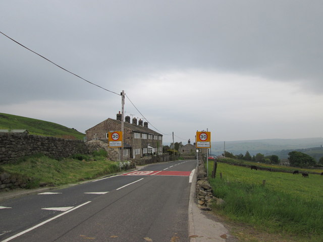
Old Town is a charming and historic village located in the heart of Yorkshire, England. Situated amidst picturesque countryside, this quaint settlement is known for its rich history, traditional architecture, and welcoming atmosphere. With a population of around 2,500 residents, Old Town exudes a strong sense of community and offers a peaceful escape from the bustling city life.

The village dates back to medieval times and is steeped in history. Its narrow, cobbled streets wind their way through rows of well-preserved stone houses, creating a nostalgic ambiance that transports visitors back in time. The centerpiece of the village is the magnificent St. Mary's Church, a stunning example of Gothic architecture that stands proudly at the village square.

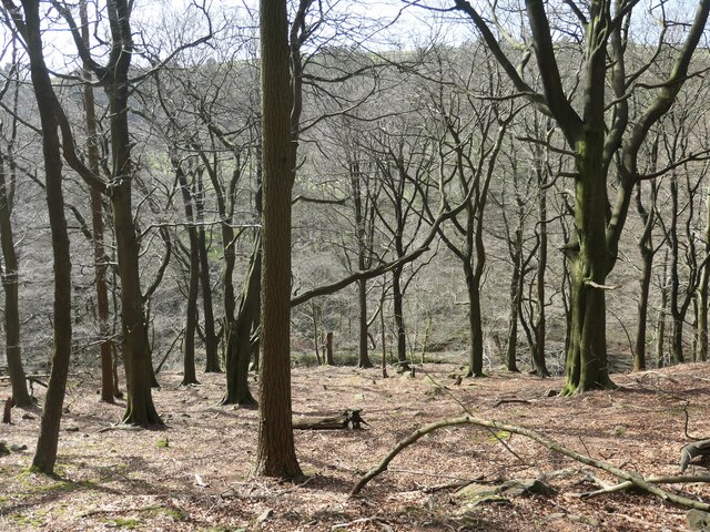
Old Town is also home to several charming local shops, cafes, and pubs, where visitors can enjoy a warm cup of tea or indulge in traditional Yorkshire delicacies. The village is surrounded by rolling hills and lush green fields, making it an ideal destination for nature lovers and hikers. The nearby Yorkshire Dales National Park offers breathtaking landscapes, with picturesque trails that lead to stunning viewpoints and hidden waterfalls.

Throughout the year, Old Town hosts various cultural events and festivals, celebrating its heritage and showcasing local talent. The village has a strong sense of community spirit, with residents actively participating in activities and initiatives that promote the well-being of the area.

In conclusion, Old Town, Yorkshire, is a captivating destination that seamlessly blends history, natural beauty, and a warm community atmosphere. With its quaint streets, stunning architecture, and surrounding countryside, this village offers a delightful escape for those seeking a taste of traditional Yorkshire charm.

If you have any feedback on the listing, please let us know in the comments section below.

Town, Old Images

Images are sourced within 2km of 53.751515/-2.003758 or Grid Reference SD9928. Thanks to Geograph Open Source API. All images are credited.

The Rochdale Canal at Hebden Bridge
Aqueduct in Crimsworth Dean The aqueduct connects a dam on the west side of Bridge Clough with one on the east. These dams connect with ones lower down the valley and all appeared to service Midgehole Dye Works
Aqueduct in Crimsworth Dean
The aqueduct connects a dam on the west side of Bridge Clough with one on the east. These dams connect with ones lower down the valley and all appeared to service Midgehole Dye Works
Cottages at New Delight
Weir on Bridge Clough, Wadsworth This is one of several weirs on this stream, and as there seems to be no open channel at that level I think that water must have been abstracted directly into a pipe laid in the river bank.
Weir on Bridge Clough, Wadsworth
This is one of several weirs on this stream, and as there seems to be no open channel at that level I think that water must have been abstracted directly into a pipe laid in the river bank.
Aqueduct bridge over Bridge Clough, Wadsworth According to information attached to a photograph that I have seen on the internet, this bridge carries flow from a millpond on the other side of the stream. There is also a well-used path across it.
Aqueduct bridge over Bridge Clough, Wadsworth
According to information attached to a photograph that I have seen on the internet, this bridge carries flow from a millpond on the other side of the stream. There is also a well-used path across it.
Millpond above Bridge Clough, Wadsworth There is a string of millponds along the eastern hillside of Crimsworth Dean, above the stream where it is called Bridge Clough. These intercept streams coming down through Purprise Wood and Middle Dean Wood. They were built in 1860-1 to increase the supply of water to Midgehole Dyeworks (captioned Crimsworth Dyeworks on the 1:2500 map of c.1893). The works had been converted from Upper Midgehole Mill (cotton) during the 'Cotton Panic', a depression in the textile industry caused by overproduction and by import restrictions due to the American Civil War. (Information from 'From Fulling to Fustionopolis' website) The dyeworks survived until 2009. The uppermost millpond (they are also called water lodges) was on the other side of the stream, with outflow crossing the stream on an aqueduct bridge (not the one thus captioned on the current 'Explorer' map). There are also some weirs on the stream, but I don't know whether they also supplied water to the dyeworks, or perhaps to the Lower Midgehole cotton mill. A voluntary organisation called 'Slow the Flow, Calderdale', who are investigating ways to reduce the risk of flooding in the Calder Valley, considered recommending that the ponds be restored to store rainfall runoff, but I think that they probably found that the work would cost too much.
Millpond above Bridge Clough, Wadsworth
There is a string of millponds along the eastern hillside of Crimsworth Dean, above the stream where it is called Bridge Clough. These intercept streams coming down through Purprise Wood and Middle Dean Wood. They were built in 1860-1 to increase the supply of water to Midgehole Dyeworks (captioned Crimsworth Dyeworks on the 1:2500 map of c.1893). The works had been converted from Upper Midgehole Mill (cotton) during the 'Cotton Panic', a depression in the textile industry caused by overproduction and by import restrictions due to the American Civil War. (Information from 'From Fulling to Fustionopolis' website) The dyeworks survived until 2009. The uppermost millpond (they are also called water lodges) was on the other side of the stream, with outflow crossing the stream on an aqueduct bridge (not the one thus captioned on the current 'Explorer' map). There are also some weirs on the stream, but I don't know whether they also supplied water to the dyeworks, or perhaps to the Lower Midgehole cotton mill. A voluntary organisation called 'Slow the Flow, Calderdale', who are investigating ways to reduce the risk of flooding in the Calder Valley, considered recommending that the ponds be restored to store rainfall runoff, but I think that they probably found that the work would cost too much.
Wadsworth Footpath 35 in Purprise Wood Here the path crosses one of the many little streams that flow down the hillside.
Wadsworth Footpath 35 in Purprise Wood
Here the path crosses one of the many little streams that flow down the hillside.
Purprise Wood, east bank of Bridge Clough This wood is on the earliest large scale OS map, surveyed in the late 1840s.
Purprise Wood, east bank of Bridge Clough
This wood is on the earliest large scale OS map, surveyed in the late 1840s.
"Follow the splodges of yellow paint on the trees" Waymarked public footpath in Purprise Wood. Quoted from 'Route 23: High Brown Knoll, White Hill & Crimsworth Dean from Hebden Bridge' in Christopher Goddard's guidebook, 'The West Yorkshire Moors'.
"Follow the splodges of yellow paint on the trees"
Waymarked public footpath in Purprise Wood. Quoted from 'Route 23: High Brown Knoll, White Hill & Crimsworth Dean from Hebden Bridge' in Christopher Goddard's guidebook, 'The West Yorkshire Moors'.
Duck Hill, Hebden Bridge Row of houses named Duck Hill, alongside Keighley Road (A6033)
Duck Hill, Hebden Bridge
Row of houses named Duck Hill, alongside Keighley Road (A6033)
New Delight, Keighley Road, Crimsworth The top-most houses of the hamlet, probably built for handloom weavers.
New Delight, Keighley Road, Crimsworth
The top-most houses of the hamlet, probably built for handloom weavers.
Bridgegate
Bridgegate
The White Swan
The White Swan
Shoulder Of Mutton
Shoulder Of Mutton
Canal lock
Canal lock
Canal view
Canal view
Keighley Road
Keighley Road
The Flying Saucer at Hebden Bridge Cafe and studio in old canal warehouse
The Flying Saucer at Hebden Bridge
Cafe and studio in old canal warehouse
Show me another place!

Town, Old is located at Grid Ref: SD9928 (Lat: 53.751515, Lng: -2.003758)

Division: West Riding

Unitary Authority: Calderdale

Police Authority: West Yorkshire

What 3 Words

///juicy.budding.window. Near Hebden Bridge, West Yorkshire

Related Wikis

Old Town, West Yorkshire

Old Town is a village in Calderdale, West Yorkshire, England. It is situated on a hilltop above Hebden Bridge and across the Hebden valley from Heptonstall...

Wadsworth, West Yorkshire

Wadsworth is a civil parish in the Metropolitan Borough of Calderdale in West Yorkshire, England. It has a population of 1,456, increasing to 1,603 at...

Wainsgate Baptist Church

Wainsgate Baptist Church is a redundant chapel standing in an elevated position above the town of Hebden Bridge, West Yorkshire, England (grid reference...

Chiserley

Chiserley is a hamlet located on a hilltop near the town of Hebden Bridge, in the county of West Yorkshire, England. The Hamlet falls within the Calder...

Birchcliffe Baptist Church

Birchcliffe Baptist Church is a redundant Baptist chapel in the town of Hebden Bridge, West Yorkshire, England. It was founded by Daniel Taylor in 1764...

Hepton Rural District

Hepton was a rural district in the West Riding of Yorkshire, England, from 1894 to 1974. The district included four civil parishes: Heptonstall, Blackshaw...

Hebden Royd

Hebden Royd is a civil parish in the Metropolitan Borough of Calderdale in West Yorkshire, England. According to the 2001 census it had a population of...

Hebden Bridge

Hebden Bridge is a market town in the Calderdale district of West Yorkshire, England. It is in the Upper Calder Valley, 8 miles (13 km) west of Halifax...

Nearby Amenities

Located within 500m of 53.751515,-2.003758
Turning Circle
Lat/Long: 53.7518468/-1.9994581
Booth: K6
Covered: booth
Disused Amenity: telephone
Man Made: telephone_box
Old Phone: +44 1422 842310
Lat/Long: 53.7503353/-1.9968941
Bus Stop
Akroyd Lane
Local Ref: 45020909
Naptan AtcoCode: 450020909
Naptan Bearing: N
Naptan CommonName: Akroyd Lane
Naptan Crossing: Wainsgate
Naptan Indicator: Stop 45020909
Naptan PlusbusZoneRef: LEEDS
Naptan ShortCommonName: Wainsgate
Naptan Street: Akroyd Lane
Naptan Verified: no
Source: naptan_import
Lat/Long: 53.7552497/-2.0064156
Bus Stop
Parrock Lane Old Town Mill Lane
Local Ref: 45020910
Naptan AtcoCode: 450020910
Naptan Bearing: NW
Naptan CommonName: Parrock Lane Old Town Mill Lane
Naptan Crossing: Old Town Mill Lane
Naptan Indicator: Stop 45020910
Naptan Notes: Awaiting new photo - shelter lit by Solar Panel
Naptan PlusbusZoneRef: LEEDS
Naptan ShortCommonName: Old Town Mill Lane
Naptan Street: Parrock Lane
Naptan Verified: no
Source: naptan_import
Lat/Long: 53.7537757/-2.0041556
Bus Stop
Old Town
Local Ref: 45020911
Naptan AtcoCode: 450020911
Naptan Bearing: NW
Naptan CommonName: Old Town
Naptan Crossing: Walker Lane
Naptan Indicator: Stop 45020911
Naptan PlusbusZoneRef: LEEDS
Naptan ShortCommonName: Walker Lane
Naptan Street: Billy Lane
Naptan Verified: no
Source: naptan_import
Lat/Long: 53.751313/-1.9998029
Bus Stop
Old Town
Local Ref: 45020912
Naptan AtcoCode: 450020912
Naptan Bearing: SE
Naptan CommonName: Old Town
Naptan Crossing: Walker Lane
Naptan Indicator: Stop 45020912
Naptan PlusbusZoneRef: LEEDS
Naptan ShortCommonName: Billy Lane
Naptan Street: Billy Lane
Naptan Verified: no
Source: naptan_import
Lat/Long: 53.7513399/-1.9994844
Keighley Road
Local Ref: 45024668
Naptan AtcoCode: 450024668
Naptan Bearing: S
Naptan BusStopType: CUS
Naptan CommonName: Keighley Road
Naptan Crossing: Twixt Akroyd Lane & Midgehole Road
Naptan Indicator: Stop 45024668
Naptan PlusbusZoneRef: LEEDS
Naptan ShortCommonName: Spring Wood
Naptan Street: Keighley Road
Naptan Verified: no
Source: naptan_import
Lat/Long: 53.7529845/-2.0086749
Bus Stop
Parrock Lane
Local Ref: 45025287
Naptan AtcoCode: 450025287
Naptan Bearing: SE
Naptan BusStopType: CUS
Naptan CommonName: Parrock Lane
Naptan Crossing: Wainsgate Lane
Naptan Indicator: Stop 45025287
Naptan PlusbusZoneRef: LEEDS
Naptan ShortCommonName: Akroyd Lane
Naptan Street: Parrock Lane
Naptan Verified: no
Source: naptan_import
Lat/Long: 53.7539644/-2.0043224
Bus Stop
Akroyd Lane
Local Ref: 45025763
Naptan AtcoCode: 450025763
Naptan Bearing: S
Naptan CommonName: Akroyd Lane
Naptan Crossing: Wainsgate
Naptan Indicator: Stop 45025763
Naptan PlusbusZoneRef: LEEDS
Naptan ShortCommonName: Wainsgate
Naptan Street: Akroyd Lane
Naptan Verified: no
Source: naptan_import
Lat/Long: 53.7553755/-2.0063549
Old Town
Place: village
Wikidata: Q7085254
Lat/Long: 53.7516222/-2.0043107
Leisure: playground
Lat/Long: 53.7518414/-2.0010781
Post Box
Brand: Royal Mail
Brand Wikidata: Q638098
Brand Wikipedia: en:Royal Mail
Collection Times: Mo-Fr 09:00; Sa 07:00; Su off
Operator: Royal Mail
Operator Wikidata: Q638098
Post Box Type: wall
Ref: HX7 186D
Royal Cypher: EIIR
Royal Cypher Wikidata: Q33102113
Lat/Long: 53.7538645/-2.0044611
Power: pole
Lat/Long: 53.755797/-2.0029374
Post Box
Brand: Royal Mail
Brand Wikidata: Q638098
Collection Times: Mo-Fr 16:00; Sa 11:15
Operator: Royal Mail
Operator Wikidata: Q638098
Post Box Type: wall
Ref: HX7 173
Royal Cypher: GVIR
Royal Cypher Wikidata: Q33102169
Lat/Long: 53.7504621/-1.9968312
Defibrillator
Access: yes
Defibrillator Location: outside Wadsworth Community Centre
Emergency: defibrillator
Indoor: no
Lat/Long: 53.750728/-1.998049
The data included in this document is from www.openstreetmap.org. The data is made available under ODbL.

Have you been to Town, Old?

Leave your review of Town, Old below (or comments, questions and feedback).