Bob Wood

Wood, Forest in Yorkshire

England

Bob Wood

Weir on Hebden Water, Hardcastle Crags
Weir on Hebden Water, Hardcastle Crags Credit: Humphrey Bolton

Bob Wood is a dense forest located in the picturesque region of Yorkshire, England. Covering an expansive area, it is renowned for its rich biodiversity and breathtaking scenery. This ancient woodland has been a prominent feature of the Yorkshire landscape for centuries and is cherished by locals and visitors alike.

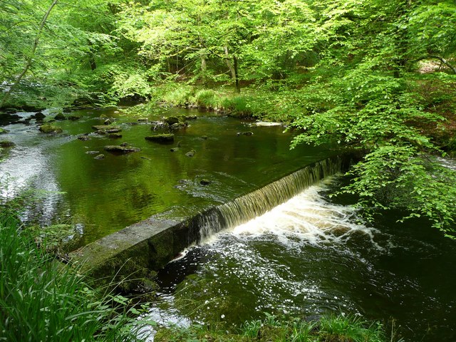
The forest boasts a diverse range of tree species, including oak, beech, birch, and ash. These majestic trees create a dense canopy that filters sunlight, resulting in a tranquil and shaded ambiance. The forest floor is adorned with a vibrant carpet of ferns, mosses, and wildflowers, adding to its natural charm.

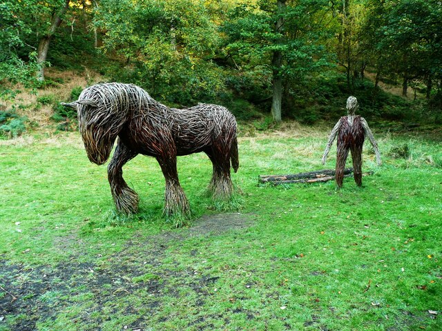
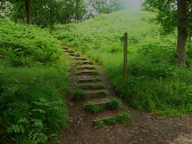
Bob Wood is not only a haven for flora but also a thriving habitat for various wildlife species. It is home to deer, foxes, badgers, and a plethora of bird species, including woodpeckers, owls, and warblers. Nature enthusiasts often indulge in birdwatching and wildlife spotting while exploring the forest's numerous walking trails.

The wood offers an enchanting atmosphere throughout the year, with each season showcasing its unique beauty. In spring, the woodland bursts into life with blossoming flowers and the songs of migrating birds. Summer brings lush greenery and dappled sunlight, perfect for leisurely walks. Autumn splashes the forest with a vibrant palette of red, orange, and gold as the leaves change color. Winter paints a tranquil scene with frost-covered trees and a hushed silence that adds to the woodland's magical appeal.

Whether it's a peaceful stroll, a family picnic, or an adventure into nature, Bob Wood in Yorkshire promises an unforgettable experience for all who visit.

If you have any feedback on the listing, please let us know in the comments section below.

Bob Wood Images

Images are sourced within 2km of 53.750289/-2.0400731 or Grid Reference SD9728. Thanks to Geograph Open Source API. All images are credited.

Weir on Hebden Water, Hardcastle Crags
Rock outcrop, Hardcastle Crags
Willow sculptures, Hardcastle Crags A carthorse and a farmer.
Willow sculptures, Hardcastle Crags
A carthorse and a farmer.
Path to the crags, Hardcastle crags
Weir on Hebden Water I don't know what was the purpose of this weir - perhaps water was piped down to one of the Gibson Mill ponds.
Weir on Hebden Water
I don't know what was the purpose of this weir - perhaps water was piped down to one of the Gibson Mill ponds.
Woodland near Hardcastle Crags The sign explains how the National Trust have a programme to remove non-native species of tree, to allow the native ones to grow back.
Woodland near Hardcastle Crags
The sign explains how the National Trust have a programme to remove non-native species of tree, to allow the native ones to grow back.
A felled trunk and bluebells near Hardcastle Crags Many bluebells are over for the year, but they are persisting in this sheltered valley.
A felled trunk and bluebells near Hardcastle Crags
Many bluebells are over for the year, but they are persisting in this sheltered valley.
Willow pony A willow sculpture of what appears to be a Dales pony at Hardcastle Crags.
Willow pony
A willow sculpture of what appears to be a Dales pony at Hardcastle Crags.
Bridleway, Lady Royd Farm Looking N along the bridleway with the hamlet of Walshaw in the distance.
Bridleway, Lady Royd Farm
Looking N along the bridleway with the hamlet of Walshaw in the distance.
Weir on Hebden Water, Hardcastle Crags Upstream from Gibson Mill
Weir on Hebden Water, Hardcastle Crags
Upstream from Gibson Mill
Widdop Road Boothroyd Farm
Widdop Road
Boothroyd Farm
The Southern End of Black Hill Looking across Hebden Dale from Mount Pleasant.  The farm to the left is Mansfield House and the one to the right is Black Scout.
The Southern End of Black Hill
Looking across Hebden Dale from Mount Pleasant. The farm to the left is Mansfield House and the one to the right is Black Scout.
Weir on Hebden Water No doubt installed as a part of the water-powered supply for nearby Gibson Mill.  The same weir as <a href="https://www.geograph.org.uk/photo/437854">SD9730 : Weir on Hebden Water, Hardcastle Crags</a> but with more water passing over.
Weir on Hebden Water
No doubt installed as a part of the water-powered supply for nearby Gibson Mill. The same weir as SD9730 : Weir on Hebden Water, Hardcastle Crags but with more water passing over.
Holding Pond, Hebden Dale The pond is a short way up stream from Gibsons Mill and would have been used as a back-up source of water to power the mill at times when the flow of Hebden Water was reduced.
Holding Pond, Hebden Dale
The pond is a short way up stream from Gibsons Mill and would have been used as a back-up source of water to power the mill at times when the flow of Hebden Water was reduced.
Open land north east of Gibson Mill, Hardcastle Crags In an otherwise steep narrow and heavily wooded valley this open area beside the main track through the estate is surprisingly flat and open.
Open land north east of Gibson Mill, Hardcastle Crags
In an otherwise steep narrow and heavily wooded valley this open area beside the main track through the estate is surprisingly flat and open.
Road to Boothroyd Farm
Hardcastle Crags trees Twisted and gnarled trees are a feature of the National Trust's Hardcastle Crags estate.
Hardcastle Crags trees
Twisted and gnarled trees are a feature of the National Trust's Hardcastle Crags estate.
Silver birch tree on Hardcastle Crags The crags are an outcrop of Millstone Grit over sandstone.
Silver birch tree on Hardcastle Crags
The crags are an outcrop of Millstone Grit over sandstone.
Show me another place!

Bob Wood is located at Grid Ref: SD9728 (Lat: 53.750289, Lng: -2.0400731)

Division: West Riding

Unitary Authority: Calderdale

Police Authority: West Yorkshire

What 3 Words

///down.forces.adverbs. Near Hebden Bridge, West Yorkshire

Related Wikis

Heptonstall

Heptonstall is a small village and civil parish within the Calderdale borough of West Yorkshire, England, historically part of the West Riding of Yorkshire...

Colden, West Yorkshire

Colden is a hamlet in the civil parish of Heptonstall in Calderdale, West Yorkshire, England. Historically part of the West Riding of Yorkshire, the hamlet...

Hepton Rural District

Hepton was a rural district in the West Riding of Yorkshire, England, from 1894 to 1974. The district included four civil parishes: Heptonstall, Blackshaw...

South Pennines Regional Park

The South Pennines Regional Park (or South Pennines Park) was a proposed national park that would cover the South Pennines area in Northern England, encompassing...

Nearby Amenities

Located within 500m of 53.750289,-2.0400731
Smithwell Lane
Local Ref: 45050863
Naptan AtcoCode: 450050863
Naptan Bearing: SW
Naptan BusStopType: CUS
Naptan CommonName: Smithwell Lane
Naptan Indicator: Stop 45050863
Naptan PlusbusZoneRef: LEEDS
Naptan ShortCommonName: Smithwell Lane
Naptan Street: Smithwell Lane
Naptan Verified: no
Source: naptan_import
Lat/Long: 53.754758/-2.0393725
Turning Circle
Lat/Long: 53.7514743/-2.0338226
Barrier: stile
Foot: yes
Lat/Long: 53.7504028/-2.046819
Barrier: stile
Foot: yes
Lat/Long: 53.750669/-2.045415
Barrier: stile
Foot: yes
Lat/Long: 53.7509794/-2.04214
Barrier: stile
Foot: yes
Lat/Long: 53.7513851/-2.0402024
Barrier: stile
Foot: yes
Lat/Long: 53.7522003/-2.0370784
Ele: 283.8
Lat/Long: 53.7525085/-2.0400511
Ele: 289.7
Lat/Long: 53.7538882/-2.0390965
Man Made: chimney
Lat/Long: 53.7502945/-2.0381665
Waterway: weir
Lat/Long: 53.7504016/-2.0372157
Man Made: chimney
Lat/Long: 53.7504792/-2.0357094
Barrier: stile
Lat/Long: 53.7484447/-2.0393046
Bench
Lat/Long: 53.752234/-2.034749
Generator Method: photovoltaic
Generator Output Electricity: yes
Generator Source: solar
Generator Type: solar_photovoltaic_panel
Power: generator
Lat/Long: 53.7538588/-2.0365082
Generator Method: photovoltaic
Generator Output Electricity: yes
Generator Source: solar
Generator Type: solar_photovoltaic_panel
Power: generator
Lat/Long: 53.7538893/-2.0361738
Generator Method: photovoltaic
Generator Output Electricity: yes
Generator Source: solar
Generator Type: solar_photovoltaic_panel
Power: generator
Lat/Long: 53.7539609/-2.0358937
Access: no
Barrier: stile
Foot: yes
Lat/Long: 53.7522675/-2.0347903
Bench
Backrest: yes
Lat/Long: 53.7522535/-2.0346858
The data included in this document is from www.openstreetmap.org. The data is made available under ODbL.

Have you been to Bob Wood?

Leave your review of Bob Wood below (or comments, questions and feedback).